
One Police Plaza is the headquarters of the New York City Police Department (NYPD). The building is located on Park Row in Civic Center, Manhattan near New York City's City Hall and the Brooklyn Bridge. Its block borders Park Row, Pearl Street, and Police Plaza. 1PP replaced the NYPD's previous headquarters at 240 Centre Street, approximately 1 mile (1.6 km) north of 1 Police Plaza.

Foley Square, also called Federal Plaza, is a street intersection in the Civic Center neighborhood of Lower Manhattan, New York City, which contains a small triangular park named Thomas Paine Park. The space is bordered by Worth Street to the north, Centre Street to the east, and Lafayette Street to the west, and is located south of Manhattan's Chinatown and east of Tribeca. It was named after a prominent Tammany Hall district leader and local saloon owner, Thomas F. "Big Tom" Foley (1852–1925).

The Michael Schimmel Center for the Arts was the principal theatre of Pace University and is located at the University's New York City campus in Lower Manhattan. Facing City Hall near the foot of the Brooklyn Bridge and blocks from the World Trade Center, it provided performance and assembly facilities to the university and the general public.
Park Row is a street located in the Financial District, Civic Center, and Chinatown neighborhoods of the New York City borough of Manhattan. The street runs east-west, sometimes called north-south because the western end is nearer to the Financial District. At the north end of Park Row is the confluence of Bowery, East Broadway, St. James Place, Oliver Street, Mott Street, and Worth Street at Chatham Square. At the street's south end, Broadway, Vesey Street, Barclay Street, and Ann Street intersect. The intersection includes a bus turnaround loop designated as Millennium Park.

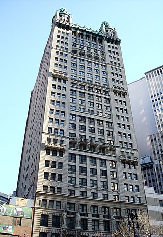
1 Pace Plaza is the flagship building complex of Pace University in New York City, located directly across from the City Hall and adjacent to the Brooklyn Bridge ramp in the Civic Center neighborhood of Manhattan. The building houses the classrooms, administrative offices, a 2,000-square-foot (190 m2) student union, the 750-seat community theater of the Michael Schimmel Center for the Arts, the Peter Fingesten Gallery, and an 18-floor high-rise known as Maria's Tower. The 5th through 17th floors of Maria's Tower houses approximately 500 freshmen residents and the 18th floor holds university administrative offices.

The Civic Center is an area and neighborhood in Lower Manhattan, Manhattan, New York City, that encompasses New York City Hall, One Police Plaza, the courthouses in Foley Square, the Metropolitan Correctional Center, and the surrounding area. The district is bound on the west by Tribeca at Broadway, on the north by Chinatown at Worth Street or Bayard Street, on the east by the East River and the Brooklyn Bridge at South Street, and on the south by the Financial District at Ann Street.

Travers Park is a 2-acre (8,100 m2) community park and playground in Jackson Heights, Queens, New York City. It is located between 77th and 78th Streets, on the north side of 34th Avenue. More than half of the park is occupied by an asphalt play area, with basketball and tennis courts. A children's playground with leaf-and-vine shaped spray shower occupies about one third of the park. There are also restroom facilities, handball courts, a dog run, picnic tables, a bicycle rack, benches, tables, and a lawn. In 2012, a segment of adjacent 78th Street was transformed into a permanent Street Plaza; the sports area of a nearby school was also bought by New York City and added to the park.

The Manhattan Waterfront Greenway is a waterfront greenway for walking or cycling, 32 miles (51 km) long, around the island of Manhattan, in New York City. The largest portions are operated by the New York City Department of Parks and Recreation. It is separated from motor traffic, and many sections also separate pedestrians from cyclists. There are three principal parts — the East, Harlem and Hudson River Greenways.

Chambers Street is a two-way street in the New York City borough of Manhattan. It runs from River Terrace, Battery Park City in the west, past PS 234, The Borough of Manhattan Community College, and Stuyvesant High School, to the Manhattan Municipal Building at 1 Centre Street in the east. Between Broadway and Centre Street, Chambers Street forms the northern boundary of the grounds surrounding New York City Hall and the Tweed Courthouse. Opposite the Tweed Courthouse sits the Surrogate's Courthouse for Manhattan. 280 Broadway the Marble Palace, lies west of there, on the north side of Chambers.
St. John's Park was a 19th-century park and square, and the neighborhood of townhouses around it, in what is now the Tribeca neighborhood of Lower Manhattan, New York City. The square was bounded by Varick Street, Laight Street, Hudson Street and Beach Street, now also known for that block as Ericsson Place. Although the name "St. John's Park" is still in use, it is no longer a park and is inaccessible to the public.

Pace University is a private university with three campuses in New York: Pace University in New York City, Pace University in Pleasantville, and Pace Law in White Plains. It was established in 1906 as a business school by the brothers Homer St. Clair Pace and Charles A. Pace. Pace enrolls about 13,000 students as of fall 2021 in bachelor's, master's and doctoral programs.

Juan Pablo Duarte Square, usually shortened to Duarte Square, is a 0.45-acre (0.18 ha) triangular park in Hudson Square, in Lower Manhattan, New York City. The park, operated by the New York City Department of Parks and Recreation, is bound by Sullivan Street and the LentSpace plot to the west, Grand Street to the north, Sixth Avenue to the east, and Canal Street and Albert Capsouto Park to the south.

Coenties Slip is a street in the Financial District of Manhattan in New York City. It runs southeast for two blocks in Lower Manhattan from Pearl Street to South Street. A walkway runs an additional block north from Pearl Street to Stone Street.

The East River Greenway is an approximately 9.44-mile-long (15.19 km) foreshoreway for walking or cycling on the east side of the island of Manhattan on the East River. It is part of the Manhattan Waterfront Greenway. The largest portions are operated by the New York City Department of Parks and Recreation. It is separated from motor traffic, and many sections also separate pedestrians from cyclists. The greenway is parallel to the Franklin D. Roosevelt East River Drive for a majority of its length.

The West Street pedestrian bridges are a series of pedestrian bridges that cross West Street to connect the neighborhoods of Tribeca and the Financial District with Battery Park City in Lower Manhattan, New York City. The bridges were built to provide alternatives to crossing the busy street. Prior to the September 11 attacks, there were three bridges at Chambers Street, Vesey Street and Liberty Street. The Vesey Street and Liberty Street bridges connected the former World Trade Center complex with the World Financial Center.

Albert Capsouto Park is a triangular-shaped pocket park in the Tribeca neighborhood of Lower Manhattan in New York City. It is bounded by Canal Street to the northeast, Varick Street to the west, and Laight Street to the south. It is located just east of the Holland Tunnel exit plaza, formerly known as St. John's Park.
Millennium Park is a small plaza located at the intersection of Park Row and Broadway in Financial District of Lower Manhattan, New York City. Located to the south of City Hall Park, it is a Greenstreet site designed to replicate a forest amid a busy intersection. The plaza contains a bus turnaround loop, formerly a paved median transformed into a green space at the turn of the 21st century.
Spring Street Park is a small triangular park in the lower Manhattan neighborhood of Hudson Square in New York City. The park is bounded by Spring Street on the north, Broome Street on the south, Avenue of the Americas on the east, and on the west by a narrow two-block street considered to be a spur of Sixth Avenue. As a pedestrian plaza, the triangle was previously known as SoHo Square.

Cortlandt Street is a west-east street in the Financial District of Lower Manhattan, New York City. It runs one block from Broadway to Church Street, then continues an additional block as the non-vehicular Cortlandt Way from Church to Greenwich Street. At its eastern end, the street continues as Maiden Lane.


