University Woods, also known as Cedar Park,[3] is a small woodland park in the University Heights neighborhood of the Bronx in New York City. Overlooking the Harlem River, the park sits between Sedgwick and Cedar Avenues. After having been named "the city's worst park" by the New Yorkers for Parks in the years 2003–2006, a restoration project was begun in 2008 by the Friends of the Woods organization, with a $500,000 grant from Mayor Michael Bloomberg.[1]
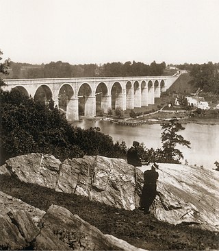
University Woods, formerly British Fort #8, has a two-tiered pathway and the original stone walls used by the British troops during the American Revolutionary War.[2] The main stairs, now pending restoration, are a popular passageway between Cedar Avenue and Sedgwick Avenue and lead further up to the Hall of Fame terrace and Bronx Community College.
Friends of the Woods is an organization founded by Brandy Cochrane in 2006 to rehabilitate and maintain the park.[4] Formerly a real estate professional she was drawn to the park while assessing housing in the vicinity. Even though Cochrane had been a resident in the neighborhood for over four years, she was stunned to discover this idyllic hideaway just blocks from her home.[4] Since that time, she has been a public supporter of not only the preservation of rural areas in her neighborhood, but of the value of community cohesiveness, inclusiveness, and assertive actions that can be taken to improve the quality of life in urban areas.[4]
Friends of The Woods received $500,000[1] from the city of New York and has set about to restore the infrastructure of University Woods. They have partnered with the Parks Department, The Harlem River Ecology Center, the New York State Horticultural Center, and many other ecologically conscious groups to make further improvements to this once abandoned woodland. DJ Kool Herc, who grew up near the park in the 1970s,[3] attended a block party held in 2008 in celebration of the park.[5]
The Bronx is a borough of New York City, coextensive with Bronx County, in the U.S. state of New York. It is south of Westchester County; north and east of the New York City borough of Manhattan, across the Harlem River; and north of the New York City borough of Queens, across the East River. The Bronx is the only New York City borough not primarily located on an island. The Bronx has a land area of 42 square miles (109 km2) and a population of 1,472,654 at the 2020 census, its highest decennial census count ever. If each borough were ranked as a city, the Bronx would rank as the ninth-most-populous in the U.S. Of the five boroughs, it has the fourth-largest area, fourth-highest population, and third-highest population density. The population density of the Bronx was 32,718.7 inhabitants per square mile (12,632.8/km2) in 2022, the third-highest population density of any county in the United States, behind Manhattan and Brooklyn. With a population that is 54.8% Hispanic as of 2020, it is the only majority-Hispanic county in the Northeastern United States and the fourth-most-populous nationwide.
Washington Heights is a neighborhood in the northern part of the borough of Manhattan in New York City. It is named for Fort Washington, a fortification constructed at the highest natural point on Manhattan by Continental Army troops to defend the area from the British forces during the American Revolutionary War. Washington Heights is bordered by Inwood to the north along Dyckman Street, by Harlem to the south along 155th Street, by the Harlem River and Coogan's Bluff to the east, and by the Hudson River to the west.
Highbridge is a residential neighborhood geographically located in the central-west section of the Bronx, New York City. Its boundaries, starting from the north and moving clockwise, are the Cross-Bronx Expressway to the north, Jerome Avenue to the east, Macombs Dam Bridge to the south, and the Harlem River to the west. Ogden Avenue is the primary thoroughfare through Highbridge.
Norwood, also known as Bainbridge, is a residential neighborhood in the northwest Bronx, New York City, U.S. It is bound by Van Cortlandt Park and Woodlawn Cemetery to the north, the Bronx River to the east, and Mosholu Parkway to the southwest. The area is dominated topographically by what was once Valentine's Hill, the highest point being near the intersection of 210th Street and Bainbridge Avenue, where Gun Hill Road intersects, and around the Montefiore Medical Center, the largest landowner and employer of the neighborhood. Norwood's main commercial arteries are Gun Hill Road, Jerome Avenue, Webster Avenue, and Bainbridge Avenue.
Williamsbridge is a neighborhood geographically located in the north-central portion of the Bronx in New York City. Its boundaries, starting from the north and moving clockwise are East 222nd Street to the north, Boston Road to the east, East Gun Hill Road to the south, and the Bronx River to the west. White Plains Road is the primary thoroughfare through Williamsbridge.
The Croton Aqueduct or Old Croton Aqueduct was a large and complex water distribution system constructed for New York City between 1837 and 1842. The great aqueducts, which were among the first in the United States, carried water by gravity 41 miles (66 km) from the Croton River in Westchester County to reservoirs in Manhattan. It was built because local water resources had become polluted and inadequate for the growing population of the city. Although the aqueduct was largely superseded by the New Croton Aqueduct, which was built in 1890, the Old Croton Aqueduct remained in service until 1955.
University Heights is a neighborhood of the West Bronx in New York City. Its boundaries, starting from the north and moving clockwise, are: West Fordham Road to the north, Jerome Avenue to the east, West Burnside Avenue to the south and the Harlem River to the west. University Avenue is the primary thoroughfare in University Heights.
St. Nicholas Avenue is a major street that runs obliquely north-south through several blocks between 111th and 193rd Streets in the New York City borough of Manhattan. The route, which follows a course that is much older than the grid pattern of the Commissioners' Plan of 1811, passes through the neighborhoods of Harlem, Hamilton Heights, and Washington Heights. It is believed to follow the course of an old Indian trail that became an important road in the 17th century between the Dutch settlement of New Amsterdam and the British New England Colonies. In the post colonial era, it became the western end of the Boston Post Road. The road became a street when row housing was being built in Harlem during its rapid urban expansion following the end of the American Civil War.
Macombs Dam Park is a park in the Concourse section of the Bronx, New York City. The park lay in the shadow of the old Yankee Stadium when it stood, between Jerome Avenue and the Major Deegan Expressway, near the Harlem River and the Macombs Dam Bridge. The park is administered and maintained by the New York City Department of Parks and Recreation. The majority of Macombs Dam Park was not open to the public from August 2006, when construction began on the new Yankee Stadium, to April 2012.
Morris Heights is a residential neighborhood located in the West Bronx. Its boundaries, starting from the north and moving clockwise are: West Burnside Avenue to the north, Jerome Avenue to the east, the Cross-Bronx Expressway to the south, and the Harlem River to the west. University Avenue is the primary thoroughfare through Morris Heights.
Mosholu Parkway is a 3.03-mile-long (4.88 km) parkway in the borough of the Bronx in New York City, constructed from 1935 to 1937 as part of the roadway network created under Robert Moses. The roadway extends between the New York Botanical Garden and Van Cortlandt Park. The New York City Department of Transportation is responsible for the operation and maintenance of the roadway while the New York City Department of Parks and Recreation is responsible for the surrounding rights-of-way. The parkway is designated as New York State Route 908F (NY 908F), an unsigned reference route, by the New York State Department of Transportation.
New York State Route 9X (NY 9X) was a 1.83-mile-long (2.95 km) state highway located within New York City. It served as an alternate route of U.S. Route 9 (US 9) through Manhattan and the Bronx. The southern terminus of the route was in the Manhattan neighborhood of Inwood; its northern terminus was in the Bronx neighborhood of Kingsbridge. NY 9X was assigned in April 1935; however, the road had been signed as a numbered highway since 1934. The designation was removed entirely in the 1940s.
Van Cortlandt Village is a subsection of the Kingsbridge neighborhood in the New York City borough of the Bronx. The neighborhood is part of Bronx Community Board 8. Named after Van Cortlandt Park, it is bordered by the Major Deegan Expressway to the west, the Jerome Park Reservoir to the east, West 238th Street to the south, and Van Cortlandt Park to the north. Its ZIP Code is 10463.
Since its founding in 1625 by Dutch traders as New Amsterdam, New York City has been a major destination for immigrants of many nationalities who have formed ethnic enclaves, neighborhoods dominated by one ethnicity. Freed African American slaves also moved to New York City in the Great Migration and the later Second Great Migration and formed ethnic enclaves. These neighborhoods are set apart from the main city by differences such as food, goods for sale, or even language. Ethnic enclaves provide inhabitants security in work and social opportunities, but limit economic opportunities, do not encourage the development of English speaking, and keep immigrants in their own culture.
Sedgwick Avenue is a major street in the Bronx, New York City. It runs roughly parallel to Jerome Avenue, the Major Deegan Expressway, and University Avenue. Sedgwick Avenue is one of the longest streets in the western part of the Bronx, running from Mosholu Parkway at the north to Macombs Dam Bridge at its southern end, about 800 feet west of Yankee Stadium.
1520 Sedgwick Avenue is a 102-unit apartment building in the Morris Heights neighborhood of the Bronx in New York City. Described in The New York Times as a long-time "haven for working class families", it has been historically accepted as the birthplace of hip hop.
New York City has the largest population of Italian Americans in the United States as well as North America, many of whom inhabit ethnic enclaves in Brooklyn, the Bronx, Manhattan, Queens, and Staten Island. New York is home to the third largest Italian population outside of Italy, behind Buenos Aires, Argentina (first) and São Paulo, Brazil (second). Over 2.6 million Italians and Italian-Americans live in the greater New York metro area, with about 800,000 living within one of the five New York City boroughs. This makes Italian Americans the largest ethnic group in the New York metro area.
St. Mary's Park is a public park in the Mott Haven neighborhood in the South Bronx section of the Bronx, New York City. The park has sporting facilities and an indoor recreation center.
Concourse is a neighborhood in the southwestern section of the New York City borough of the Bronx which includes the Bronx County Courthouse, the Bronx Museum of the Arts, and Yankee Stadium. Its boundaries, starting from the north and moving clockwise, are East 169th Street to the north, Webster Avenue to the east, East 149th Street to the south, and Jerome Avenue and Harlem River to the west. The neighborhood is divided into three subsections: West Concourse, East Concourse, and Concourse Village with the Grand Concourse being its main thoroughfare.
North Woods and North Meadow are two interconnected features in the northern section of Central Park, New York City, close to the neighborhoods of the Upper West Side and Harlem in Manhattan. The 90-acre (36 ha) North Woods, in the northwestern corner of the park, is a rugged woodland that contains a forest called the Ravine, as well as two water features called the Loch and the Pool. The western portion of the North Woods also includes Great Hill, the third highest point in Central Park. North Meadow, a recreation center and sports complex, is immediately southeast of the North Woods. Completed in the 1860s, North Woods and North Meadow were among the last parts of Central Park to be built.
This page is based on this Wikipedia article Text is available under the CC BY-SA 4.0 license; additional terms may apply. Images, videos and audio are available under their respective licenses.