Related Research Articles

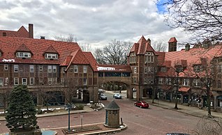
Flushing is a neighborhood in the north-central portion of the New York City borough of Queens. The neighborhood is the fourth-largest central business district in New York City. Downtown Flushing is a major commercial and retail area, and the intersection of Main Street and Roosevelt Avenue at its core is the third-busiest in New York City, behind Times Square and Herald Square.
Forest Hills is a mostly residential neighborhood in the central portion of the borough of Queens in New York City. It is adjacent to Corona to the north, Rego Park and Glendale to the west, Forest Park to the south, Kew Gardens to the southeast, and Flushing Meadows–Corona Park to the east.

Kew Gardens is a neighborhood in the central area of the New York City borough of Queens. Kew Gardens is bounded to the north by the Union Turnpike and the Jackie Robinson Parkway, to the east by the Van Wyck Expressway and 131st Street, to the south by Hillside Avenue, and to the west by Park Lane, Abingdon Road, and 118th Street. Forest Park is to the west and the neighborhood of Forest Hills to the north-west, Flushing Meadows–Corona Park north, Richmond Hill south, Briarwood southeast, and Kew Gardens Hills east.

Woodside is a residential and commercial neighborhood in the western portion of the borough of Queens in New York City. It is bordered on the south by Maspeth, on the north by Astoria, on the west by Sunnyside, and on the east by Elmhurst, Jackson Heights, and East Elmhurst. Some areas are widely residential and very quiet, while other parts, especially the ones around Roosevelt Avenue, are busier.

Fresh Meadows is a neighborhood in the northeastern section of the New York City borough of Queens. Fresh Meadows used to be part of the broader town of Flushing and is bordered to the north by the Horace Harding Expressway and Auburndale; to the west by Pomonok, St. John's University, Hillcrest, and Utopia; to the east by Cunningham Park and the Clearview Expressway; and to the south by the Grand Central Parkway.

Queens Botanical Garden is a botanical garden located at 43-50 Main Street in Flushing, Queens, New York City. The 39-acre (16 ha) site features rose, bee, herb, wedding, and perennial gardens; an arboretum; an art gallery; and a LEED-certified Visitor & Administration Building. Queens Botanical Garden is located on property owned by the City of New York, and is funded from several public and private sources. It is operated by Queens Botanical Garden Society, Inc.

Kew Gardens Hills is a neighborhood in the middle of the New York City borough of Queens. The borders are Flushing Meadows-Corona Park to the west, the Long Island Expressway to the north, Union Turnpike to the south, and Parsons Boulevard to the east.

Pomonok is a working class neighborhood in the New York City borough of Queens. This large public housing development in South Flushing was built in 1949 on the former site of Pomonok Country Club. The name comes from the Algonquian name for Long Island, and means either "land of tribute" or "land where there is travelling by water".

Kissena Park is a 235-acre (95 ha) park located in the neighborhood of Flushing in Queens, New York City. It is located along the subterranean Kissena Creek, which flows into the Flushing River. It is bordered on the west by Kissena Boulevard; on the north by Rose, Oak, Underhill, and Lithonia Avenues; on the east by Fresh Meadow Lane; and on the south by Booth Memorial Avenue. The park contains the city's only remaining velodrome, a lake of the same name, two war memorials, and various playgrounds and sports fields.

The Flushing River, also known as Flushing Creek, is a waterway that flows northward through the borough of Queens in New York City, mostly within Flushing Meadows–Corona Park, emptying into the Flushing Bay and the East River. The river runs through a valley that may have been a larger riverbed before the last Ice Age, and it divides Queens into western and eastern halves. Until the 20th century, the Flushing Creek was fed by three tributaries: Mill Creek and Kissena Creek on the eastern bank, and Horse Brook on the western bank.
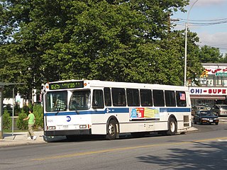
The Q74 bus route constituted a public transit line in Queens, New York City. It ran primarily along Main Street, Vleigh Place, and Union Turnpike between Queens College and the Kew Gardens–Union Turnpike subway station. Operated by the North Shore Bus Company from the 1930s to March 1947, the route was later city operated by MTA Regional Bus Operations under the New York City Transit brand until June 27, 2010, when it was discontinued under system-wide service cuts.
The Queens Community Board 8 is a local government in the New York City borough of Queens, encompassing the neighborhoods of Briarwood, Cunningham Heights, Flushing South, Fresh Meadows, Hillcrest, Hilltop Village, Holliswood, Jamaica Estates, Jamaica Hills, Kew Gardens Hills, Pomonok, and Utopia. It is delimited by the Long Island Expressway to Hillside Avenue and from the Van Wyck Expressway to the Clearview Expressway.

Main Street is a major north–south street in the borough of Queens in New York City, extending from Queens Boulevard in Briarwood to Northern Boulevard in Flushing. Created in the 17th century as one of Flushing's main roads, Main Street has been lengthened at various points in its existence.
Kissena Boulevard is a thoroughfare spanning the Flushing and Pomonok neighborhoods of the borough of Queens in New York City, extending from Main Street in the Flushing Chinatown to Parsons Boulevard in Kew Gardens Hills. The road's name is derived from Kissena Lake, a name given by 19th century horticulturist Samuel Bowne Parsons for the Chippewa word meaning, "it is cold". The lake is located in Kissena Park.

Kissena Creek is a buried stream located in the neighborhoods of Flushing, Fresh Meadows, Hillcrest, and Kew Gardens Hills in the New York City borough of Queens. Kissena Creek originates in a now-filled swamp within Kew Gardens Hills and Pomonok in central Queens, flowing east to Hillcrest. The creek then travels mostly north and west, largely flowing beneath Kissena Park Golf Course, Kissena Park, Kissena Corridor Park, and Queens Botanical Garden, before merging with the Flushing River in Flushing Meadows–Corona Park.

Judge Moses Weinstein Playground is a 3.25-acre triangular park located in the Kew Gardens Hills neighborhood of Queens, New York City.
Playground Seventy Five is a public park located on 160th Street and 75th Avenue in the Hillcrest neighborhood of Queens, New York. It was acquired by the New York City government in 1929 as part of land condemnations for the construction of Public School 154. The undeveloped section of the block was reserved as a schoolyard and developed as a playground in 1954.
Daniel Rosenthal is an American politician who was a Democratic member of the New York State Assembly, representing District 27 from 2017 to 2023. Rosenthal represents the central and eastern Queens neighborhoods of Kew Gardens Hills, Pomonok, Electchester, and College Point, and parts of Kew Gardens, Richmond Hill, Briarwood, Forest Hills, and Whitestone. On July 14, 2023, Rosenthal resigned to take a position at UJA-Federation of New York.
References
- ↑ "Playground Opened in Queens". The New York Times. 1952-01-16. ISSN 0362-4331 . Retrieved 2020-01-23.
- ↑ "Edith K. Bergtraum; Elementary Teacher, 76". The New York Times. 1994-06-02. ISSN 0362-4331 . Retrieved 2020-01-23.
- ↑ "Rep. Gary Ackerman: Naming P.S. 165 the Edith K. Bergtraum School". Congressional Record. 141 (82). 1995-05-17. Retrieved January 23, 2020.