
North River is an alternative name for the southernmost portion of the Hudson River in the vicinity of New York City and northeastern New Jersey in the United States. The entire watercourse was known as the North River by the Dutch in the early seventeenth century; the term fell out of general use for most of the river's 300+ mile course during the early 1900s. However the name remains in very limited use as an artifact among history-inclined local mariners and others and on some nautical charts and maps. The term is also used for infrastructure on and under the river, such as the North River piers, North River Tunnels, and the North River Wastewater Treatment Plant.

The Jersey Shore is the coastal region of the U.S. state of New Jersey. Geographically, the term encompasses about 141 miles (227 km) of oceanfront bordering the Atlantic Ocean, from Perth Amboy in the north to Cape May Point in the south. The region includes Middlesex, Monmouth, Ocean, Atlantic, and Cape May counties, which are in the central and southern parts of the state. Located in the center of the Northeast Megalopolis, the northern half of the shore region is part of the New York metropolitan area, while the southern half of the shore region is part of the Delaware Valley. The Jersey Shore hosts the highest concentration of oceanside boardwalks in the United States.

East River Park, also called John V. Lindsay East River Park, is 57.5-acre (20 ha) public park located on the Lower East Side of Manhattan, part of the New York City Department of Parks and Recreation. Bisected by the Williamsburg Bridge, it stretches along the East River from Montgomery Street up to 12th Street on the east side of the FDR Drive. Its amphitheater, built in 1941 just south of Grand Street, has been reconstructed and is often used for public performances. The park includes football, baseball, and soccer fields; tennis, basketball, and handball courts; a running track; and bike paths, including the East River Greenway. Fishing is another popular activity.

Carl Schurz Park is a 14.9-acre (6.0 ha) public park in the Yorkville neighborhood of Manhattan, New York City, named for German-born Secretary of the Interior Carl Schurz in 1910, at the edge of what was then the solidly German-American community of Yorkville. The park contains Gracie Mansion, the official residence of the Mayor of New York.

Exchange Place is a district of Downtown Jersey City, New Jersey, United States, that is sometimes referred to as "Wall Street West" due to the concentration of financial companies that have offices there. The namesake is a square, about 200 feet long, at the foot of Montgomery Street at the Hudson River. This square was created by landfilling the shore at Paulus Hook, and has been a major transportation hub since the colonial era.

Hudson River Park is a waterside park on the North River that extends from 59th Street south to Battery Park in the New York City borough of Manhattan. The park, a component of the Manhattan Waterfront Greenway, stretches 4.5 miles (7.2 km) and comprises 550 acres (220 ha), making it the second-largest park in Manhattan after the 843-acre (341 ha) Central Park.
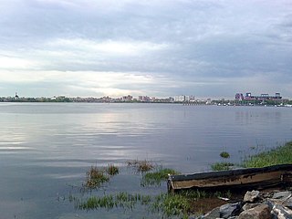
Flushing Bay is a tidal embayment in New York City. It is located on the south side of the East River and stretches to the south near the neighborhood of Flushing, Queens. It is bordered on the west by LaGuardia Airport and the Grand Central Parkway, on the south by Northern Boulevard, and on the east by the neighborhood of College Point. The Flushing River empties into the bay at its southeast corner. A 150-foot-wide navigational channel (46 m) dredged at a depth of 14 feet (4.3 m) runs along much of the bay's length.

Brooklyn Bridge Park is an 85-acre (34 ha) park on the Brooklyn side of the East River in New York City. Designed by landscape architecture firm Michael Van Valkenburgh Associates, the park is located on a 1.3-mile (2.1 km) plot of land from Atlantic Avenue in the south, under the Brooklyn Heights Promenade and past the Brooklyn Bridge, to Jay Street north of the Manhattan Bridge. From north to south, the park includes the preexisting Empire–Fulton Ferry and Main Street Parks; the historic Fulton Ferry Landing; and Piers 1–6, which contain various playgrounds and residential developments. The park also includes Empire Stores and the Tobacco Warehouse, two 19th-century structures, and is a part of the Brooklyn Waterfront Greenway, a series of parks and bike paths around Brooklyn.

The Manhattan Waterfront Greenway is a waterfront greenway for walking or cycling, 32 miles (51 km) long, around the island of Manhattan, in New York City. The largest portions are operated by the New York City Department of Parks and Recreation. It is separated from motor traffic, and many sections also separate pedestrians from cyclists. There are three principal parts — the East, Harlem and Hudson River Greenways.

The Hudson River Waterfront Walkway, also known as the Hudson River Walkway, is a promenade along the Hudson Waterfront in New Jersey. The ongoing and incomplete project located on Kill van Kull and the western shore of Upper New York Bay and the Hudson River was implemented as part of a New Jersey state-mandated master plan to connect the municipalities from the Bayonne Bridge to the George Washington Bridge with an urban linear park and provide contiguous unhindered access to the water's edge.

The East Side of Manhattan refers to the side of Manhattan which abuts the East River and faces Brooklyn and Queens. Fifth Avenue, Central Park from 59th to 110th Streets, and Broadway below 8th Street separate it from the West Side.

DeWitt Clinton Park is a 5.8-acre (23,000 m2) New York City public park in the Hell's Kitchen neighborhood of Manhattan, New York City, between West 52nd and 54th Streets, and Eleventh and Twelfth Avenues.

Stuyvesant Cove Park is a 1.9-acre (7,700 m2) public park on the East Side of the New York City borough of Manhattan that runs from 18th Street to 23rd Street between the FDR Drive and the East River. Part of the East River Greenway, it is located to the south of the Waterside Plaza apartment complex, to the east of Stuyvesant Town–Peter Cooper Village, and to the north of the East River Park, and connects to the Captain Patrick J. Brown Walk on the south end.

Robert Moses Playground is a 1.3-acre (0.53 ha) playground and park in Manhattan, New York City. It is located in the Murray Hill neighborhood on First Avenue between 41st and 42nd streets, immediately south of the headquarters of the United Nations. The park is named for New York's "master builder" Robert Moses, then the head of the Triborough Bridge and Tunnel Authority, which constructed the playground as part of the construction of the Queens–Midtown Tunnel.

The East River Greenway is an approximately 9.44-mile-long (15.19 km) foreshoreway for walking or cycling on the east side of the island of Manhattan on the East River. It is part of the Manhattan Waterfront Greenway. The largest portions are operated by the New York City Department of Parks and Recreation. It is separated from motor traffic, and many sections also separate pedestrians from cyclists. The greenway is parallel to the Franklin D. Roosevelt East River Drive for a majority of its length.

Ferry Point Park is a 413.8-acre (167.5 ha) park in the Bronx, New York City. The park site is a peninsula projecting into the East River roughly opposite the College Point and Malba neighborhoods of Queens. The park is located on the eastern shore of Westchester Creek, adjacent to the neighborhood of Throggs Neck. The park is operated by the New York City Department of Parks and Recreation. The Hutchinson River Expressway crosses the park to the Bronx-Whitestone Bridge, splitting it into east and west sides.
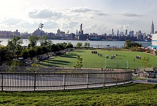
Bushwick Inlet Park is a public park in the Williamsburg neighborhood of Brooklyn, New York City. The park currently stretches along the East River between North 9th and 12th Streets, and is eventually planned to reach into Greenpoint at Quay Street. The park is named for Bushwick Inlet, which will be in a future northern extension.
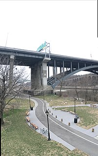
Bridge Park is a park in the Bronx, New York, created as part of a larger vision of creating connected waterfront parks along both sides of the Harlem River. The park's name references three large arch bridges linking Manhattan and the Bronx: Alexander Hamilton Bridge, Washington Bridge, and High Bridge.
Shore Boulevard Mall is a waterfront promenade extending for nearly a mile along the southern bank of Sheepshead Bay in the Manhattan Beach neighborhood of Brooklyn, New York.

The expansion of the land area of Lower Manhattan in New York City by land reclamation has, over time, greatly altered Manhattan Island along the shorelines of the Hudson and East rivers; as well as those of the Upper New York Bay. The extension of island's landmass began with European colonialization and continued in the 20th century. Incremental encroachment as well as major infrastructure have added acreage to the island. Since the passage of the Rivers and Harbors Act of 1899 all projects which extend into navigable waterways follow federal regulation and are overseen the United States Army Corps of Engineers.
