Boston Spa is a village and civil parish in the City of Leeds metropolitan borough in West Yorkshire, England. Situated 3 miles (5 km) south of Wetherby, Boston Spa is on the south bank of the River Wharfe which separates it from Thorp Arch. According to the 2001 census the parish had a population of 4,006 rising to 4,079 in the 2011 census.

Otley is a market town and civil parish at a bridging point on the River Wharfe, in the City of Leeds metropolitan borough in West Yorkshire, England. Historically a part of the West Riding of Yorkshire, the population was 13,668 at the 2011 census. It is in two parts: south of the river is the historic town of Otley and to the north is Newall, which was formerly a separate township. The town is in lower Wharfedale on the A660 road which connects it to Leeds.

Ilkley is a spa town and civil parish in the City of Bradford in West Yorkshire, in Northern England. Historically part of the West Riding of Yorkshire, Ilkley civil parish includes the adjacent village of Ben Rhydding and is a ward within the City of Bradford. Approximately 12 miles (19 km) north of Bradford and 17 miles (27 km) north-west of Leeds, the town lies mainly on the south bank of the River Wharfe in Wharfedale, one of the Yorkshire Dales.

Arthington is a small village in Wharfedale, in the City of Leeds metropolitan borough in West Yorkshire, England. It is a civil parish which, according to the 2011 census, had a population of 532 and is in the LS21 postcode district with Otley as its post town. It is in the Otley ward of the City of Leeds, and the Leeds North West parliamentary constituency.

Wharfedale is the valley of the upper parts of the River Wharfe and one of the Yorkshire Dales. It is situated within the districts of Craven and Harrogate in North Yorkshire, and the cities of Leeds and Bradford in West Yorkshire. It is the upper valley of the River Wharfe. Towns and villages in Wharfedale include Buckden, Kettlewell, Conistone, Grassington, Hebden, Bolton Abbey, Addingham, Ilkley, Burley-in-Wharfedale, Otley, Pool-in-Wharfedale, Arthington, Collingham and Wetherby. Beyond Wetherby, the valley opens out and becomes part of the Vale of York.

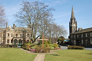
Grassington is a market town and civil parish in the Craven district of North Yorkshire, England. The population of the parish at the 2011 Census was 1,126. Historically part of the West Riding of Yorkshire, the town is situated in Wharfedale, about 8 miles (10 km) north-west from Bolton Abbey, and is surrounded by limestone scenery. Nearby villages include Linton, Threshfield, Hebden, Conistone and Kilnsey.

Cookridge is a suburb of north-west Leeds, West Yorkshire, England, north of the Leeds Outer Ring Road. In 1715 Ralph Thoresby described it as a village four miles from Leeds and three from Otley, dating from 1540.

Linton is a village 1.5 miles (2.4 km) south-west of Wetherby in West Yorkshire, England, in the parish of Collingham and the City of Leeds metropolitan borough. At the 2011 Census the village fell within the Harewood ward of the City of Leeds Council. It lies between Wetherby and Sicklinghall, on the north bank of the River Wharfe, opposite Collingham on the south bank.
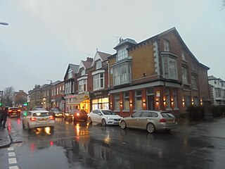
Burley in Wharfedale is a village and a civil parish in the City of Bradford in West Yorkshire, England. It is situated in the Wharfedale valley.
Wharfedale was a rural district in the West Riding of Yorkshire from 1894 to 1974. It comprised the northern side of lower Wharfedale, the lower Washburn Valley and several parishes between Leeds and the River Wharfe. Until 1937 it also included a detached part, the parish of Esholt north of Bradford.

Conistone is a small village in the Craven district of North Yorkshire, England. It lies 3 miles (5 km) north of Grassington, 3 miles (5 km) south of Kettlewell and 12 miles (19 km) north of Skipton beside the River Wharfe, in Upper Wharfedale.

Pool-in-Wharfedale or Pool in Wharfedale, usually abbreviated to Pool, is a village and civil parish in the Lower Wharfedale area, 10 miles (16 km) north of Leeds city centre, 11 miles (18 km) north-east of Bradford, and 2 miles (3.2 km) east of Otley. It is in the City of Leeds metropolitan borough, West Yorkshire and within the historic boundaries of the West Riding of Yorkshire. It is in the LS21 (Otley) postcode district.
Weston is a village and civil parish in the Harrogate district of North Yorkshire, England. The village is 1.2 miles (2 km) north–west of Otley and near the River Wharfe which forms the boundary between North and West Yorkshire. The name is from Old English and means western enclosure, farmstead or village.

Denton Hall is an English country house located to the north of the River Wharfe, at Denton, Borough of Harrogate, North Yorkshire, England between Otley and Ilkley, and set within a larger Denton estate of about 2,500 acres (10 km2), including a village, church, and landscaped gardens. It is a Grade I listed building.

Wharfedale Hospital is located in the market town of Otley, West Yorkshire, England, and is managed by the Leeds Teaching Hospitals NHS Trust.

The City of Leeds is a city and metropolitan borough in West Yorkshire, England. The metropolitan borough includes the administrative centre of Leeds and the towns of Farsley, Garforth, Guiseley, Horsforth, Morley, Otley, Pudsey, Rothwell, Wetherby and Yeadon. It has a population of 793,139 (mid-2019 est.), making it technically the second largest city in England by population behind Birmingham, since London is not a single local government entity. It is governed by Leeds City Council.
Newall with Clifton is a civil parish in the Harrogate district of North Yorkshire, England. It lies two miles north of Otley in West Yorkshire. The main settlement in the parish is the small village of Clifton. Despite its name, Newall is no longer in the parish, and lies across the border in West Yorkshire. They are joined by Newall Carr Road, which runs North from Otley Bridge. In the 2011 census the population of the parish was 147.

Otley and Yeadon is an electoral ward of Leeds City Council in north west Leeds, West Yorkshire, covering the towns of Otley and Yeadon as well as Newall.
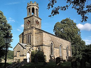
The Church of St Helen, Denton is a parish church in the hamlet of Denton, near Otley, in North Yorkshire, England. The church was built in 1776 by the architect John Carr, who constructed it in the Gothic style, whereas he usually favoured the Classic style in his architecture. The church was built around a picture window taken from the chapel that it supplanted on the Denton Hall estate. The picture window still exists and is noted for being the only complete picture window by the artist Henry Gyles. A second piece of painted glass exists in the church, by the glass-painted William Peckitt. Whilst the church it is not a consecrated structure, services can take place there, and it is popular with people marrying due to its location close to a reception venue nearby.

Nesfield is a small village, 2 miles (3.2 km) north-west of Ilkley on the north bank of the River Wharfe, in the civil parish of Nesfield with Langbar, in the Harrogate district, in the county of North Yorkshire, England. Historically in the West Riding of Yorkshire, the village sits at the southern edge of the Nidderdale Area of Outstanding Natural Beauty.


