Newport (town), Vermont

Last updated
Newport, Vermont [1] [2] [3]
Town
Newport town vt highlight.png
Located in Orleans County, Vermont
Map of USA VT.svg
Location of Vermont with the U.S.A.
Coordinates: 44°56′39″N72°18′2″W / 44.94417°N 72.30056°W / 44.94417; -72.30056 Coordinates: 44°56′39″N72°18′2″W / 44.94417°N 72.30056°W / 44.94417; -72.30056
Country United States
State Vermont
County Orleans
CharteredOctober 30, 1802
Area
  Total43.5 sq mi (112.6 km2)
  Land41.7 sq mi (108.0 km2)
  Water1.8 sq mi (4.6 km2)
Elevation
792 ft (284 m)
Population
 (2000)
  Total1,511
  Density36.2/sq mi (14.0/km2)
  Households
587
  Families
436
Time zone UTC-5 (EST)
  Summer (DST) UTC-4 (EDT)
ZIP code
05857
Area code 802
FIPS code 50-48925 [4]
GNIS feature ID1462162 [5]

Newport is a town in Orleans County, Vermont, United States. The population was 1,526 at the 2020 census. [6] The town is referred to by the United States Postal Service and the media as Newport Center, the name of the main settlement of the town. Newport is also the name of neighboring Newport City.

Contents

Government

Town

School District

Geography

According to the United States Census Bureau, the town has a total area of 43.5 square miles (112.6 km2), of which 41.7 square miles (108.0 km2) is land and 1.8 square miles (4.6 km2) (4.07%) is water. [8]

The unincorporated village of Newport Center is located roughly in the geographic center of town. The town also contains a smaller, secondary settlement, South Newport, located in the southern part of town.

History

Newport was formed on October 26, 1781, and chartered under the name of Duncansboro, to George Duncan, Nathan Fisk, and 63 others on October 30, 1802. Amos Sawyer, Enos Bartlett, James C. Adams were the first town selectman. Amos Sawyer was also the first Town Clerk. These were among the first settlers of Duncansboro. The name was altered from Duncansboro to Newport, October 30, 1816.[ citation needed ]

The first clearing, which began where Newport Center is now, was made by H. & A. Adams and D. & S. Meacham. Here they constructed a dam and put up a waterwheel sawmill on Mud Creek. Amos Sawyer, a carpenter by trade, built a home nearby. Two other settlements were established in the town: South Newport and Pickeral Point, later renamed to Lake Bridge (named for its location at the head of Lake Memphremagog). By the late 19th century, the Boston and Maine and Central Vermont railroads were routed through Lake Bridge and the small village experienced a population boom. In 1868, the Lake Bridge settlement was incorporated as the "Village of Newport". The main town village, Newport Center, was also incorporated in 1908.[ citation needed ]

In 1917, the Village of Newport separated from the Town of Newport and merged with the Village of West Derby (in the town of Derby) to form the City of Newport. In 1931, by special acts of the General Assembly, the Village of Newport Center consolidated with the Town of Newport, with its former responsibilities automatically assumed by the town. [9]

Demographics

Historical population
CensusPop.Note
1800 50
1810 28−44.0%
1820 5285.7%
1830 284446.2%
1840 591108.1%
1850 74826.6%
1860 1,19760.0%
1870 2,05071.3%
1880 2,42618.3%
1890 3,04725.6%
1900 1,239−59.3%
1910 1,236−0.2%
1920 1,187−4.0%
1930 1,1930.5%
1940 1,064−10.8%
1950 966−9.2%
1960 1,0104.6%
1970 1,12511.4%
1980 1,31917.2%
1990 1,3673.6%
2000 1,51110.5%
2010 1,5945.5%
2020 1,526−4.3%
U.S. Decennial Census [10] [11]

As of the census [4] of 2000, there were 1,511 people, 587 households, and 436 families residing in the town. The population density was 36.2 people per square mile (14.0/km2). There were 746 housing units at an average density of 17.9/sq mi (6.9/km2). The racial makeup of the town was 97.35% White, 0.26% Black or African American, 0.73% Native American, 0.26% Asian, 0.07% Pacific Islander, and 1.32% from two or more races. Hispanic or Latino of any race were 0.53% of the population.

There were 587 households, out of which 33.0% had children under the age of 18 living with them, 62.0% were married couples living together, 7.8% had a female householder with no husband present, and 25.6% were non-families. 19.1% of all households were made up of individuals, and 5.5% had someone living alone who was 65 years of age or older. The average household size was 2.57 and the average family size was 2.93.

In the town, the population was spread out, with 26.5% under the age of 18, 5.8% from 18 to 24, 28.5% from 25 to 44, 27.8% from 45 to 64, and 11.4% who were 65 years of age or older. The median age was 39 years. For every 100 females, there were 103.1 males. For every 100 females age 18 and over, there were 102.4 males.

The US Census Bureau estimates that the town's population increased 19.1% between 2000–2005, the second largest increase in the state of Vermont. [12]

Economics

Personal Income

The median income for a household in the town was $34,758, and the median income for a family was $43,828. Males had a median income of $28,063 versus $21,389 for females. The per capita income for the town was $17,677. About 10.1% of families and 12.7% of the population were below the poverty line, including 19.1% of those under age 18 and 4.1% of those age 65 or over.

Notable people

See also

Related Research Articles

<span class="mw-page-title-main">Orleans County, Vermont</span> County in Vermont, United States

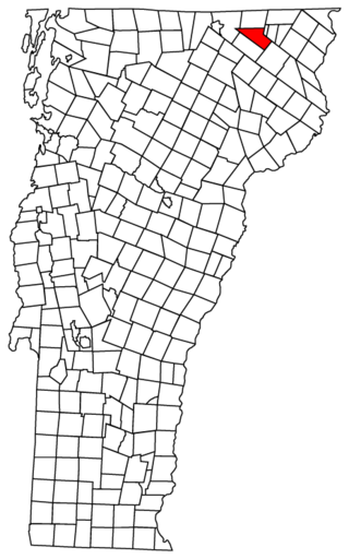
Orleans County is a county located in the northeastern part of the U.S. state of Vermont. As of the 2020 census, the population was 27,393. Its shire town is the city of Newport. The county was created in 1792 and organized in 1799. As in the rest of New England, few governmental powers have been granted to the county. The county is an expedient way of grouping and distributing state-controlled governmental services.

<span class="mw-page-title-main">Waterford, Vermont</span> Town in Vermont, United States

Waterford is a town in Caledonia County, Vermont, United States. The population was 1,268 at the 2020 census.

<span class="mw-page-title-main">Brighton, Vermont</span> Town in Vermont, United States

Brighton is a town in Essex County, Vermont, United States. The population was 1,157 at the 2020 census. The town was named "Gilead" in its original grant in 1780. The town was sold to a group consisting primarily of soldiers commanded by Colonel Joseph Nightingale and subsequently named "Random". The town's name was finally changed by the legislature to "Brighton" in 1832. The Brighton village of Island Pond gets its name from the Abenaki word Menanbawk, which literally means island pond.

<span class="mw-page-title-main">Island Pond, Vermont</span> Census-designated place in Vermont, United States

Island Pond is a census-designated place (CDP) in the town of Brighton in Essex County, Vermont, United States. The population was 750 at the 2020 census. It is part of the Berlin, NH–VT Micropolitan Statistical Area.

<span class="mw-page-title-main">Maidstone, Vermont</span> Town in Vermont, United States

Maidstone is a town in Essex County, Vermont, United States. As of the 2020 census, the town had a population of 211. It is part of the Berlin, NH–VT Micropolitan Statistical Area. There is no town center or gas station, but there is a town office building in the southern part of the town.

<span class="mw-page-title-main">Enosburgh, Vermont</span> Town in Vermont, United States

Enosburgh is a town in Franklin County, Vermont, in the United States. The population was 2,810 at the 2020 census. Enosburgh includes the village of Enosburg Falls and the settlements of Bordoville, East Enosburgh, North Enosburgh, Sampsonville, West Enosburgh, and Enosburgh Center. Enosburgh was named for Roger Enos, who had been a commander of all the Vermont Forces in the American Revolution. He was also the father-in-law of Ira Allen, founder of Vermont. The spelling of Enosburgh differs from the spelling of Enosburg Falls.

<span class="mw-page-title-main">South Hero, Vermont</span> Town in Vermont, United States

South Hero is a town on Grand Isle in Grand Isle County, Vermont, United States. South Hero's population was 1,674 at the 2020 census.

<span class="mw-page-title-main">Eden, Vermont</span> Town in Vermont, United States

Eden is a town in Lamoille County, Vermont, United States. The population was 1,338 at the 2020 census.

<span class="mw-page-title-main">Morristown, Vermont</span> Town in Vermont, United States

Morristown is a town in Lamoille County, Vermont, United States. As of the 2020 census, the population was 5,434. Morristown is the largest town by population in Lamoille County, and its central village of Morrisville serves as the county's main commercial center.

<span class="mw-page-title-main">Charleston, Vermont</span> Town in Vermont, United States

Charleston is a town in Orleans County, Vermont, United States. The population was 1,021 at the 2020 census. The town contains three unincorporated villages: Charleston, East Charleston and West Charleston.

<span class="mw-page-title-main">Coventry, Vermont</span> Town in Vermont, United States

Coventry is a town in Orleans County, Vermont, United States. The population was 1,100 at the 2020 census.

<span class="mw-page-title-main">Craftsbury, Vermont</span> Town in Vermont, United States

Craftsbury is a town in Orleans County, Vermont, United States. The population was 1,343 at the 2020 census. The town includes the unincorporated villages of Craftsbury, Craftsbury Common, Mill Village, and East Craftsbury.

<span class="mw-page-title-main">Derby, Vermont</span> Town in Vermont, United States

Derby is a town in Orleans County, Vermont, United States. The population was 4,579 at the 2020 census, making it the most populous community in Orleans County. The town contains four unincorporated villages: Beebe Plain, Clyde Pond, Lake Salem, and North Derby, and two incorporated villages: Derby Center and Derby Line.

<span class="mw-page-title-main">Glover, Vermont</span> Town in Vermont, United States

Glover is a town in Orleans County, Vermont, in the United States. As of the 2020 census, the town's population was 1,114. It contains two unincorporated villages, Glover and West Glover.

<span class="mw-page-title-main">Morgan, Vermont</span> Town in Vermont, United States

Morgan is the easternmost town in Orleans County, Vermont, United States. The population was 638 at the 2020 census. The town contains two villages: Morgan and Morgan Center.

<span class="mw-page-title-main">Castleton, Vermont</span> Town in Vermont, United States

Castleton is a town in Rutland County, Vermont, United States. Castleton is about 15 miles (24 km) to the west of Rutland, the county's seat and most populous city, and about 7 miles (11 km) east of the New York/Vermont state border. The town had a population of 4,458 at the 2020 census. Castleton University is located there, with roots dating to 1787.

<span class="mw-page-title-main">Cavendish, Vermont</span> Town in Vermont, United States

Cavendish is a town in Windsor County, Vermont, United States. The town was likely named after William Cavendish, 4th Duke of Devonshire. The population was 1,392 at the 2020 census. The town of Cavendish includes the unincorporated villages of Cavendish and Proctorsville.

<span class="mw-page-title-main">Albany, Vermont</span> Town in Vermont, United States

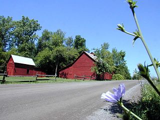
Albany is a town in Orleans County, Vermont, United States. The population was 976 at the 2020 census. Albany contains four villages: the incorporated village of Albany, and the unincorporated villages of Albany Center, East Albany and South Albany.

<span class="mw-page-title-main">Newport (city), Vermont</span> City in Vermont, United States

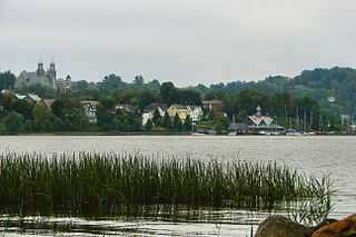
Newport is the only city in, and the shire town of, Orleans County, Vermont, United States. As of the 2020 Census, the population was 4,455. The city contains the second-largest population of any municipality in the county, and has the smallest geographic area. It is the second-smallest city by population in Vermont. Newport is also the name of neighboring Newport Town.

<span class="mw-page-title-main">Ludlow (town), Vermont</span> Town in Vermont, United States

Ludlow is a town in Windsor County, Vermont, United States. The population was 2,172 at the 2020 census. Ludlow is the home of Okemo Mountain, a popular ski resort. Before becoming a ski destination, Ludlow was originally a mill town, and was the home of a General Electric plant until 1977. It was named after Ludlow, Massachusetts which is less than 100 miles away. There is also a village of Ludlow in the town.

References

  1. Vermont Secretary of State accessed January 24, 2008
  2. Vermont Elections Archived 2008-02-12 at the Wayback Machine accessed January 24, 2008
  3. Resolution of the Vermont State Legislature accessed January 24, 2008
  4. 1 2 "U.S. Census website". United States Census Bureau . Retrieved 2008-01-31.
  5. "US Board on Geographic Names". United States Geological Survey. 2007-10-25. Retrieved 2008-01-31.
  6. "Census - Geography Profile: Newport town, Orleans County, Vermont" . Retrieved January 3, 2022.
  7. Voters slash $40,000 from school budget,The Chronicle,March 7, 2007, page 13
  8. "US Gazetteer files: 2010, 2000, and 1990". United States Census Bureau. 2011-02-12. Retrieved 2011-04-23.
  9. Archives of the Secretary of State Archived 2011-05-18 at the Wayback Machine accessed January 24, 2008
  10. "Census of Population and Housing". Census.gov. Retrieved June 4, 2015.
  11. "Vermont History Explorer" . Retrieved August 7, 2015.
  12. "Top 10 Towns/Cities in Vermont by Percent Growth, 2000-2005". archive.org. 30 August 2006. Archived from the original on 30 August 2006.
  13. Tomkins, Calvin (28 September 2009). "Mr. Moma" via www.newyorker.com.