Newton Loch, South Ayrshire

Last updated

Newton Loch
Newton Loch.jpg
Newton Loch on William Aiton's Map of 1811
South Ayrshire UK relief location map.jpg
Red pog.svg
Newton Loch
LocationNewton-on-Ayr, South Ayrshire, Scotland
Coordinates Coordinates: 55°28′35.8″N4°36′20.7″W / 55.476611°N 4.605750°W / 55.476611; -4.605750
Type Drained freshwater loch
Primary inflows Sanquhar and Crook mosses, rainwater and surface drainage
Primary outflows Half Mile and Lochside Burns
Catchment area Newton and St Quivox Parish
Basin  countriesScotland
Settlements Ayr

Newton Loch was situated in a low-lying area near Newton-on-Ayr, South Ayrshire, just south of the old South and West Sanquhar Farms. [1] It is now (2016) only visible as remnant heath land and surface darkening in pastureland, situated mainly in the Parish of Ayr and partly in St Quivox, South Ayrshire, Scotland.

Contents

The original outflow of Newton Loch was directly into the sea at Newton-on-Ayr via the Half Mile Burn [2] and another outflow was the lade that ran down the Newton-on-Ayr Main Street to the Newton Mill or Malt Mill that was located on the bank of the River Ayr near where the New Bridge of Ayr is located.

History

As stated, Newton loch was a natural feature, sitting in a depression, probably created by glaciation and originally shaped somewhat like a map of Great Britain on a west-east orientation. [3] The loch waters originally drained and the area is indeed still partly drained via the Half Mile Burn that now flows underground until it empties into the sea via a pipe at the Newton-on-Ayr promenade. A second outflow also once existed via a mill lade that ran down the Newton-on-Ayr Main Street to power the Newton or Malt Mill [4] that was located near where Ayr 'New Bridge' is now located. The loch received its water supply from the Sanquhar and Crook mosses in addition to rainfall and land runoff. [5]

Scotland relief location map.jpg
Red pog.svg
Newton Loch
Previous location of Newton Loch, South Ayrshire

Newton or Malt Mill

The Newton or Malt Mill was located at the end of Main Street in Newton-on-Ayr on the banks of the River Ayr [6] [7] and was named thus because of its location and because just across the river once stood the ancient Malt Cross, one of Ayr's old market places and a site for the delivering of civic justice such as the burning of witches. [8] [9]

The mill lade ran fully exposed along the side of the Newton-on-Ayr Main Street and would have been a serious nuisance to pedestrians as well as horses, cattle, carts and other road traffic. [10] In 1641 the Newton Burgh Court ruled that "..na personne or personnis sall wash at ye leid betwixt ye dam and ye mylne any foul claithis, puddings, lynnt, hydis or any other fulzie or pollutit thyngis qrby ye watter may be pollutit or fyillit be night or be day." [11]

The mill was not shown on the 1818 map by Wood however it must have survived until at least 1832 because it is recorded that it was used as a shelter by people who took part in the riots linked to the First Reform Election. [12] William Aiton's map of 1811 suggests that water may still have been available for the mill.

The draining of Newton Loch

The outlet of the Half Mile Burn at Newton-on-Ayr promenade. Half Mile Burn - sea outlet, Newton-on-Ayr promenade.jpg
The outlet of the Half Mile Burn at Newton-on-Ayr promenade.
A remnant area of the old loch near Lochside Road. Newton Loch site, Sanquhar Farm, Newton-on-Ayr.jpg
A remnant area of the old loch near Lochside Road.

The loch served a practical purpose when it provided a water supply for the Newton or Malt Mill, [13] however the farmers found the loch's land to be very rich leading to it being progressively drained and neatly divided up as shown on Ordnance Survey maps. [14] The land in 2016 still appears from aerial images to be formed of a black, loamy soil. [15]

The First Moss Dails and the Second Moss Dails were the site of the loch, two of the five Dails or portions/shares [16] of fields in Newton-on-Ayr. [17] By 1747 only a small area of open water appears to be shown near Sanquhar Farm on Roys Map and the areas around are under cultivation. [18] Andrew Armstrong's 1775 map indicates that no open water remained at all, [19] however William Aiton's map of 1811 (see above) may indicate two open areas of water, one of which may be Newton Loch.

The 1895 Ordnance Survey map does show a small area of surviving open water and associated wetland near Heathfield Road and this was possibly the last remnant of the once fairly extensive Newton Loch [20] that is show as a wetland without open water in circa 1947 situated to the south of Heathlands Hospital [21] in an area now occupied by a housing estate.

Placename evidence

Names such as the locality of Lochside, Lochside Road, Mosside, Crookmoss, Damside, Burnside, Newtonmor, Sanquhar (moss) [22] and Heathfield recall the existence of the old loch, its outflows and inflows. [23] 'Noltmire Road' is located near site of the old Heathfield Hospital and means 'boggy land where cattle graze'. [24] Newton or Malt Mill, Burnboig and Boghall are recorded on older maps. [25]

The three 'Sanquhar' farms may even hint at the presence of a crannog, typical of many of the old Ayrshire lochs as 'Sanquhar' is Gaelic for 'Old Fort' [26] although it may simply refer to the old Newton Castle that was originally known as Sanquhar Castle.

Coal mining

The lade running down to the Newton or Malt Mill also carried water from a pumping station linked to a coal pit near the old loch, the water table in the locality being very close to the surface at the time. The loch having been drained by 1775 only drainage and water from such sources were available to power the mill. [27]

Roads and railways

The old roads to Edinburgh and Glasgow ran through the area. [28] The Glasgow and South Western Railway's 'Ayr Branch' and 'Ayr and Mauchline Branch' both run across the site of the old loch. [29]

Micro-history

The Half Mile Burn was once the Parliamentary boundary of the Burgh of Ayr. [30] [31]

See also

Related Research Articles

Heathfield, South Ayrshire

Heathfield is a major district of Ayr, Scotland. Heathfield is on the borders of Ayr and Prestwick and is located beside the A77 Ayr by-pass. The Whitletts roundabout in Heathfield is the main roundabout connecting Ayr with other towns and cities. Heathfield has a lot of aviation history especially during World War II where there was an RAF base called RAF Heathfield.

Lugton Human settlement in Scotland

Lugton is a small village or hamlet in East Ayrshire, Scotland with a population of 80 people. The A736 road runs through on its way from Glasgow, 15 miles (24.1 km) to the north, to Irvine in North Ayrshire. Uplawmoor is the first settlement on this 'Lochlibo Road' to the north and Burnhouse is to the south. The settlement lies on the Lugton Water which forms the boundary between East Ayrshire and East Renfrewshire as well as that of the parishes of Dunlop and Beith.

Craigie Castle

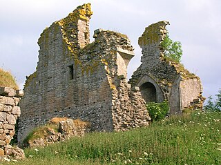
Craigie Castle, in the old Barony of Craigie, is a ruined fortification situated about 4 miles (6.4 km) southeast of Kilmarnock and 1 mile (1.6 km) southeast of Craigie village, in the Civil Parish of Craigie, South Ayrshire, Scotland. The castle is recognised as one of the earliest buildings in the county. It lies about 1.25 miles (2 km) west-south-west of Craigie church. Craigie Castle is protected as a scheduled monument.

Lochlea, South Ayrshire

Lochlea or Lochlie was situated in a low-lying area between the farms and dwellings of Lochlea and Lochside in the Parish of Tarbolton, South Ayrshire, Scotland. The loch was natural, sitting in a hollow created by glaciation. The loch waters ultimately drained via Fail Loch, the Mill Burn, and the Water of Fail. It is well-documented due to the presence of a crannog that was excavated and documented circa 1878, and its association with the poet Robert Burns, who lived here for several years whilst his father was the tenant. Lochlea lies 2+12 miles northeast of Tarbolton, and just over three miles northwest of Mauchline.

Halket Loch

Halket Loch' also known as Halkhead or Halketh, was situated in the mid-Ayrshire clayland near Lugton. It is visible as a surface depression in pastureland, sometimes partially flooded, situated in a low-lying area close to farms and dwellings of East, North and Middle Halket and Craighead in the Parish of Dunlop, East Ayrshire, Scotland. The loch was natural, sitting in a hollow created by glaciation. The loch waters drained via the Glazert Water that joins the Annick Water.

Loch Brown

Loch Brown, also known in Scots as Loch Broun, Broon or Broom, was situated in a kettle hole in the mid-Ayrshire clayland near Crosshands. It is nowadays (2011) visible as a surface depression in pastureland, partially flooded, situated in a low-lying area close to farms and dwellings of Skeoch, Dalsangan, Ladebrae, Lochhill, and Crosshands, mainly in the Parish of Mauchline and partly in Craigie, East Ayrshire, Scotland. Duveloch is an old name for the loch and this may derive from the Gaelic Dubh, meaning black or dark loch.

Helenton Loch

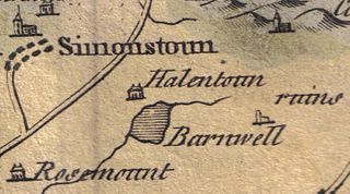
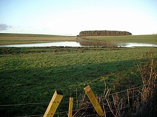
Helenton Loch was situated in a low lying area between the farms and dwellings of Helentongate, Mains, and Burnbank in the Parish of Symington, South Ayrshire, Scotland. The loch was natural, sitting in a hollow, a kettle hole, created by glaciation. The loch waters ultimately drained via the Pow Burn. Helenton Hill is a prominent landmark to the west of the old loch site. The nearby lands of Rosemount were in 1549 known as 'Goldring' and were the property of the Schaws of Sornbeg.

Fail Loch

Fail Loch or Faile Loch was situated in a low-lying area near the old monastery of Fail in the Parish of Tarbolton, South Ayrshire, Scotland. The old Lochlea Loch lies nearby and its waters still feed into Fail Loch via the Mill Burn.

Blae Loch (Beith) A lake in Ayrshire, Scotland

The Blae Loch is a small freshwater loch situated in a hollow in a low-lying area beneath Blaelochhead Hill in the Parish of Beith, North Ayrshire, Scotland.

Clevens Loch, Ayrshire

Clevens Loch was a substantial freshwater loch situated in a low-lying area below Clevance Farm and Langholm Farm in Dundonald parish, South Ayrshire, Scotland.

Loch of Trabboch

The Loch of Trabboch or Dalrympleston Loch (NS440211) was situated in a low-lying area below the old Castle of Trabboch, once held by the Boyd family in the Parish of Stair, East Ayrshire, Scotland.

Loch of Stair

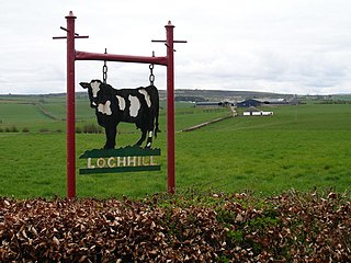
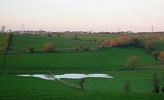
The Loch of Stair was a typical Ayrshire post-glacial 'Kettle Hole', situated in a low-lying area below the farm of Loch Hill, in the Parish of Stair, East Ayrshire, Scotland. This freshwater loch was drained in the 19th century, leaving a wetland area which still periodically floods.

Martnaham Loch

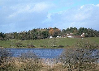
Martnaham Loch is a freshwater loch lying across the border between East and South Ayrshire Council Areas, two kilometres from Coylton, in the parishes of Coylton and Dalrymple, three miles from Ayr. The loch lies along an axis from northeast to southwest. The remains of a castle lie on a possibly artificial islet within the loch. The Campbells of Loudoun once held the lands, followed by the Kennedys of Cassillis.

Loch Shield

Loch Shield, originally Loch of Scheel was a freshwater loch in the East Ayrshire Council Area, now drained, near Drongan, lying in a glacial Kettle Hole, Parish of Ochiltree, Scotland.

Black Loch (New Cumnock)

Black Loch is a freshwater loch, named from its dark waters, situated in the East Ayrshire Council Area, between Cumnock and New Cumnock, lying in a glacial Kettle Hole mainly within the Parish of New Cumnock, a small portion protruding into Old Cumnock Parish. It is said to be one of only two lochs or lakes in the world that have outflows running to two separate destinations. The 'Runner' is a deep and broad ditch that was dug many years back to link the three lochs of Lowes, Black, and Creoch.

Haugh, East Ayrshire Human settlement in Scotland

Haugh or The Haugh is a small village or hamlet in East Ayrshire, Parish of Mauchline, Scotland. The habitation is situated about two and a half miles downstream from Catrine, on the north bank of the River Ayr. The River Ayr Way runs through the village.

Bloak Human settlement in Scotland

Bloak was a hamlet or clachan in East Ayrshire, Parish of Stewarton, Scotland. The habitation was situated between Auchentiber and Stewarton on the B778. It was originally built as a row of housing for crofters and farm workers. The small school remained open for some years after the hamlet ceased to exist. Robinson gives the Scots word "blout" as meaning "an eruption of fluid", or a place that is soft or wet.

Dalmusternock, East Ayrshire

Dalmusternock (NS455417) was a dower house built and occupied by William Mure after his marriage and prior to inheriting the family seat of Rowallan Castle. The property is located near Fenwick, in the Barony of Rowallan, lying 3 miles north of Kilmarnock and 18 miles south of Glasgow, Parish of Fenwick, East Ayrshire, Scotland. The estate is recorded as Dalmunsternoch circa 1654; Dalmasternock circa 1747; Dalmusterknok 1775

Lands of Borland, Barony of Cumnock Human settlement in Scotland

The Lands of Borland or Boreland formed a castle and land holdings within the old Barony of Cumnock, East Ayrshire, Parish of Old Cumnock, Scotland. Lying two miles south of Cumnock the property was mainly held by a cadet branch of the Hamilton family from around 1400 before passing by marriage to the Montgomeries and others. For consistency the spelling 'Borland' will be used throughout.

What now survives of the old Caprington Loch (NS402352) is situated near Earlston, Riccarton, East Ayrshire, Scotland. The loch was a natural feature, sitting in a hollow on the old Caprington Castle estate. The loch waters drain via the Todrigs Burn that flows into the River Irvine to the east of Gatehead village. It was partly drained, probably sometime after the 1820s, as were so many other lochs, as part of 18th and 19th centuries extensive agricultural improvements and the only area of open water that remains does so as it was once used as a curling pond for the Caprington Castle Estate owners and their employees or tenants.

References

Notes

  1. The Province of Kyle by Timothy Pont
  2. The Province of Kyle by Timothy Pont
  3. The Province of Kyle by Timothy Pont
  4. Gazetteer for Scotland - Ayr
  5. Dunlop, page 80
  6. Mills of the River Ayr by John Hume
  7. Wilson, page 28
  8. Ayrshire Townscapes
  9. Brash, page 14
  10. Dunlop, page 80
  11. Dunlop, page 80
  12. Dunlop, page 80
  13. Dunlop, page 80
  14. Ayrshire Sheet XXXIII. Publication date: 1897 Date revised: 1895
  15. Google Maps
  16. Dictionary of the Scots Language
  17. Dunlop, page 80
  18. 1747-55 - William ROY - Military Survey of Scotland
  19. 1775 - Andrew ARMSTRONG - A new map of Ayrshire
  20. Ayrshire Sheet XXXIII.NW. Publication date: 1897. Date revised: 1895
  21. Ayrshire Sheet XXXIII.NW. Probable Publication date: ca. 1947
  22. Dunlop, page 79
  23. The South Part of the Shire of Ayr, containing Kyle and Carrick by H. Moll.
  24. Dictionary of the Scots Language
  25. 1747-55 - William ROY - Military Survey of Scotland
  26. "Gaelic Placenames". Archived from the original on 22 November 2015. Retrieved 12 July 2016.
  27. Dunlop, page 79
  28. 1747-55 - William ROY - Military Survey of Scotland
  29. Ayrshire Sheet XXXIII. Publication date: 1897 Date revised: 1895
  30. Dunlop, page 79
  31. Ayrshire Sheet XXXIII. Publication date: 1897 Date revised: 1895

Sources

  1. Brash, Ronald W. (1986). Round Old Ayr - A Guided Walk. Ayshire Archaeological & Natural History Society.
  2. Dunlop, Annie I. (1953). The Royal Burgh of Ayr. Edinburgh : Oliver and Boyd.
  3. Wilson, James Pearson. The Last Miller. The Cornmills of Ayrshire. Ayrshire Archaeological and Natural History Society. ISBN   0-9527445-6-2.