Ninety Six is a town in Greenwood County, South Carolina, United States. The population was 1,998 at the 2010 census.

Bighorn Canyon National Recreation Area is a national recreation area established by an act of Congress on October 15, 1966, following the construction of the Yellowtail Dam by the Bureau of Reclamation. It is one of over 420 sites managed by the U.S. National Park Service. The recreation area spans 120,296.22 acres, straddling the border between Wyoming and Montana. It is divided into two distinct areas, the North District accessed via Fort Smith, Montana and the South District accessed through Lovell, Wyoming. There is no thru road inside the recreation area connecting the two districts. The Yellowtail Dam is located in the North District. It is named after the famous Crow leader Robert Yellowtail, harnesses the waters of the Bighorn River by turning that variable watercourse into Bighorn Lake. The lake extends 71 miles (114 km) through Wyoming and Montana, 55 miles (89 km) of which lie within the national recreation area. The lake provides recreational boating, fishing, water skiing, kayaking, and birding opportunities to visitors. About one third of the park unit is located on the Crow Indian Reservation. Nearly one-quarter of the Pryor Mountains Wild Horse Range lies within the Bighorn Canyon National Recreation Area.
Moores Creek National Battlefield is a battlefield managed by the U.S. National Park Service. The park commemorates the 1776 victory of a thousand patriots over about eight hundred loyalists at Moore's Creek. The battle dashed the hopes of British provincial governor Josiah Martin for regaining control of North Carolina for the Crown. The loyalist defeat simultaneously ended British plans for an invasionary force to land in Brunswick Town. The Second Continental Congress voted to declare independence from the British on July 4, 1776, shortly after the battle; which took place in the Wilmington area near Currie in Pender County in southeastern North Carolina. The national military park was established on June 2, 1926, and was redesignated as a national battlefield on September 8, 1980.
The Cherokee Path was the primary route of English and Scots traders from Charleston to Columbia, South Carolina in Colonial America. It was the way they reached Cherokee towns and territories along the upper Keowee River and its tributaries. In its lower section it was known as the Savannah River. They referred to these towns along the Keowee and Tugaloo rivers as the Lower Towns, in contrast to the Middle Towns in Western North Carolina and the Overhill Towns in present-day southeastern Tennessee west of the Appalachian Mountains.
The Battle of Kettle Creek was the first major victory for Patriots in the back country of Georgia during the American Revolutionary War that took place on February 14, 1779. It was fought in Wilkes County about eleven miles (18 km) from present-day Washington, Georgia. A militia force of Patriots decisively defeated and scattered a Loyalist militia force that was on its way to British-controlled Augusta.

The Sycamore Shoals of the Watauga River, usually shortened to Sycamore Shoals, is a rocky stretch of river rapids along the Watauga River in Elizabethton, Tennessee. Archeological excavations have found Native Americans lived near the shoals since prehistoric times, and Cherokees gathered there. As Europeans began settling the Trans-Appalachian frontier, the shoals proved strategic militarily, as well as shaped the economies of Tennessee and Kentucky. Today, the shoals are protected as a National Historic Landmark and are maintained as part of Sycamore Shoals State Historic Park.

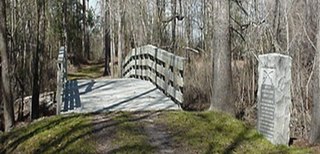
The Battle of Musgrove Mill, August 19, 1780, occurred near a ford of the Enoree River, near the present-day border between Spartanburg, Laurens and Union Counties in South Carolina. During the course of the battle, 200 Patriot militiamen defeated a combined force of approximately 300 Loyalist militiamen and 200 provincial regulars.
Ninety-Six District is a former judicial district in the U.S. state of South Carolina. It existed as a district from July 29, 1769 to December 31, 1799. The court house and jail for Ninety-Six District were in Ninety Six, South Carolina.

The siege of Fort Watson was an American Revolutionary War confrontation in South Carolina that began on April 15, 1781 and lasted until April 23, 1781. Continental Army forces under Henry "Light Horse Harry" Lee and South Carolina militia under Francis Marion besieged Fort Watson, a fortified British outpost that formed part of the communication and supply chain between Charleston and other British outposts further inland.
John Stuart was a Scottish-born official of the British Empire in the colony of South Carolina, North America. He was the superintendent for the southern district of the British Indian Department from 1761 to 1779; his northern counterpart was Sir William Johnson, based in the colony of New York.
The siege of Augusta took place between May 22, 1781, and June 6, 1781. American Patriot forces, led by General Andrew Pickens and Colonel Henry "Light Horse Harry" Lee, were successful in capturing Augusta, Georgia held by British loyalist militia. Fort Cornwallis, the primary British defence, was successfully exposed to cannon fire by the construction of a tower 30 feet (9.1 m) high on which the Americans mounted a small cannon. The British surrendered on June 6.

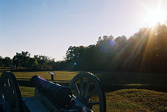
The siege of Ninety Six was a siege in western South Carolina late in the American Revolutionary War. From May 22 to June 18, 1781, Continental Army Major General Nathanael Greene led 1,000 troops in a siege against the 550 Loyalists in the fortified village of Ninety Six, South Carolina. The 28-day siege centered on an earthen fortification known as Star Fort. Despite having more troops, Greene was unsuccessful in taking the town, and was forced to lift the siege when Lord Rawdon approached from Charleston with British troops.

Musgrove Mill State Historic Site was the site of the Battle of Musgrove Mill, an action in the American Revolutionary War, which occurred on August 19, 1780, near the Enoree River, on what is the border between Spartanburg, Laurens, and Union Counties in South Carolina, approximately seven miles from Interstate 26.
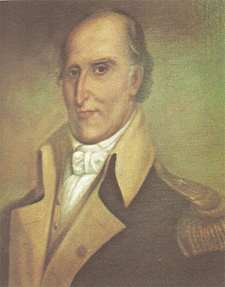
Brigadier-General Andrew Williamson was a Scottish-born trader, planter, and military officer. Serving in the South Carolina Militia, rising to be commissioned as brigadier general in the Continental Army in the American War of Independence. He led numerous campaigns against Loyalists and Cherokee, who in 1776 had launched an attack against frontier settlements across a front from Tennessee to central South Carolina. Williamson was particularly effective in suppressing the Cherokee, killing an unknown number of Cherokees and destroying 31 of their towns. As a result of his Indian campaign, the Cherokee ceded more than a million acres in the Carolinas.
William "Bloody Bill" Cunningham (1756–1787) was an American loyalist infamous for perpetrating a series of bloody massacres in South Carolina's backcountry in the fall of 1781 as commander of a Tory militia regiment in the Revolutionary War. Though his family were loyal to the British crown, Cunningham initially enlisted in the Continental Army as part of the State of South Carolina's 3rd regiment in 1775. His tenure in the rebel army was an unhappy one and Cunningham changed sides to fight for the British in 1778. He earned the nickname "Bloody Bill" for the violent, ruthless nature of his raids on rebels and patriot civilians.

The Snow Campaign was one of the first major military operations of the American Revolutionary War in the southern colonies. An army of up to 3,000 Patriot militia under Colonel Richard Richardson marched against Loyalist recruiting centers in South Carolina, flushing them out and frustrating attempts by the Loyalists to organize. The Patriot expedition became known as the Snow Campaign due to heavy snowfall in the later stages of the campaign.
The siege of Savage's Old Fields was an encounter between Patriot and Loyalist forces in the back country town of Ninety Six, South Carolina, early in the American Revolutionary War. It was the first major conflict in South Carolina in the war, having been preceded by bloodless seizures of several military fortifications in the province.

Southern Railway Depot, also known as Ninety Six Depot, is a historic train station located at Ninety Six, Greenwood County, South Carolina. It was built in 1915 by the Southern Railway, and is a combination passenger and freight depot. It is a one-story, rectangular brick building with a flared hipped roof, bay window, station master's room, and segregated waiting rooms.

Buford's Massacre Site, also known as Buford's Battleground, is a historic site and national historic district located near Lancaster, South Carolina. Two monuments at the site mark the battleground where the Battle of Waxhaws took place. A white monument ten feet tall, erected on June 2, 1860, marked the gravesite of American soldiers who died during the battle. This marker was gradually damaged over time by souvenir hunters who chipped off pieces, which led local authorities to erect a new monument on May 1, 1955, bearing the same inscription. The Battle of Waxhaws was a minor engagement during the American Revolutionary War between the Continental Army and Loyalist forces led by British colonel Banastre Tarleton, who became known as "Bloody Tarleton" as a result of accusations that his men massacred wounded American soldiers during the battle.
Lindley's Fort Site is a historic archaeological site located near Madens, Laurens County, South Carolina. The site is located on a wooded hill, the highest rise of land surrounded mostly by open fields. It is believed that the fort was constructed by a private individual for needed protection in the backcountry. It is possible that the fort was built during the early 1760s since there were Indian disturbances in the area during that time. Captain James Lindley, owner of the fort at the time of the American Revolutionary War, was a Loyalist. On July 15, 1776, Lindley's Fort became very important to the area residents, when part of the British plan of attack was to encourage Indian uprisings in the backcountry.