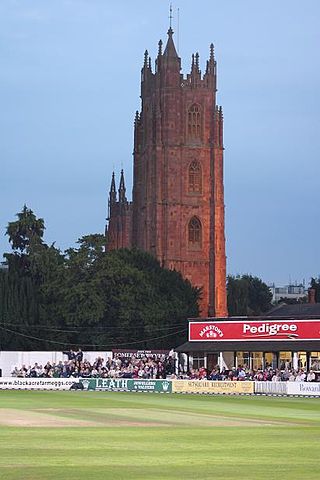
Taunton is the county town of Somerset, England, with a 2011 population of 69,570. Its thousand-year history includes a 10th-century monastic foundation, Taunton Castle, which later became a priory. The Normans built a castle owned by the Bishops of Winchester. Parts of the inner ward house were turned into the Museum of Somerset and Somerset Military Museum. For the Second Cornish uprising of 1497, Perkin Warbeck brought an army of 6,000; most surrendered to Henry VII on 4 October 1497. On 20 June 1685 the Duke of Monmouth crowned himself King of England here in a rebellion, defeated at the Battle of Sedgemoor. Judge Jeffreys led the Bloody Assizes in the Castle's Great Hall. The Grand Western Canal reached Taunton in 1839 and the Bristol and Exeter Railway in 1842. Today it hosts Musgrove Park Hospital, Somerset County Cricket Club, is the base of 40 Commando, Royal Marines, and is home to the United Kingdom Hydrographic Office on Admiralty Way. The popular Taunton flower show has been held in Vivary Park since 1866, and on 13 March 2022, St Mary Magdalene parish church was elevated to the status of Taunton Minster.

North Petherton is a small town and civil parish in Somerset, England, situated on the edge of the eastern foothills of the Quantocks, and close to the edge of the Somerset Levels. The town has a population of 6,730 as of 2014. The parish includes Hamp, Melcombe, Shearston, Woolmersdon and Huntworth.

Bishop's Hull is a village and civil parish in Somerset, England, situated in the western suburbs of Taunton in the Somerset West and Taunton district. It includes the areas of Rumwell, Rumwell Park, Roughmoor and Longaller and is close to the River Tone. The parish, which includes the hamlet of Netherclay, has a population of 2,975 in total.

Stoke St Gregory is a village and civil parish in Somerset, England, about 7 miles (11 km) east of Taunton in the Somerset West and Taunton district. The village is on a low ridge of land between the River Tone to the north and West Sedgemoor to the south. The 2011 Census recorded the parish's population as 942.
Wiveliscombe is a small town and civil parish in Somerset, England, situated 9 miles (14 km) west of Taunton in the Somerset West and Taunton district. The town has a population of 2,893. The Square, fronted by several listed structures, held the former market. The parish includes the nearby hamlet of Maundown.
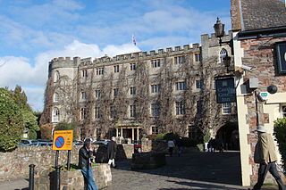
The Castle Hotel at Taunton is a hotel with two restaurants, Castle Bow Restaurant and BRAZZ, located in the centre of Taunton, Somerset, England. The business is located in a Grade II listed 18th-century reconstruction of the former 12th-century Norman fortress, Taunton Castle.

The Municipal Buildings are historic buildings in Corporation Street, Taunton, Somerset, England. The buildings, which were the home of Taunton Grammar School before becoming the headquarters of Taunton Borough Council, are Grade II* listed.

The Grade I listed buildings in Somerset, England, demonstrate the history and diversity of its architecture. The ceremonial county of Somerset consists of a non-metropolitan county, administered by Somerset County Council, which is divided into five districts, and two unitary authorities. The districts of Somerset are West Somerset, South Somerset, Taunton Deane, Mendip and Sedgemoor. The two administratively independent unitary authorities, which were established on 1 April 1996 following the breakup of the county of Avon, are North Somerset and Bath and North East Somerset. These unitary authorities include areas that were once part of Somerset before the creation of Avon in 1974.
Taunton Deane is a local government district with borough status in the English county of Somerset. In the United Kingdom, the term listed building refers to a building or other structure officially designated as being of special architectural, historical or cultural significance; Grade I structures are those considered to be "buildings of exceptional interest". Listing was begun by a provision in the Town and Country Planning Act 1947. Once listed, severe restrictions are imposed on the modifications allowed to a building's structure or its fittings. In England, the authority for listing under the Planning Act 1990 rests with Historic England, a non-departmental public body sponsored by the Department for Digital, Culture, Media and Sport; local authorities have a responsibility to regulate and enforce the planning regulations.

Nailsea Court in Nailsea, Somerset, England, is an English manor house dating from the 15th century. Pevsner describes the house as "historically highly instructive and interesting" and it is a Grade I listed building.
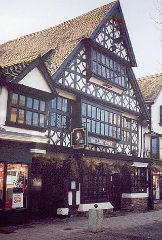
The Tudor Tavern at No 15 Fore Street, Taunton, Somerset, England has been designated as a Grade I listed building. Built in 1578, the house is three storeys high of a timber-frame construction, with jettied first and second floors. The frontage is of carved bressummers with interlocking curved braces, while the roof is red tiles. There is a medieval hall with an open trussed roof behind the front.

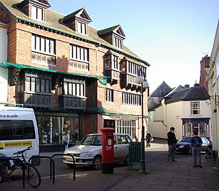
Hammet Street is a street in Taunton, Somerset, England, that runs between the Church of St Mary Magdalene and the town centre. It is named after Sir Benjamin Hammet, who had a bill passed through parliament to allow him to build the street in 1788. The street includes four listed buildings: numbers 4 and 5–8, 9–12, 13–17, and number 18 with 33 Fore Street. The first three buildings are grade II* listed, while the last is grade II listed, and together with the Church of St Mary Magdalene and the listed buildings in Church Square, the English Heritage consider them to "form an extremely important group."

The Church of St George is a Roman Catholic church in Taunton, Somerset, which dates from the mid-19th century. It was the second Catholic church to be built in Taunton after the Reformation, replacing the much smaller St George's Chapel. The main church building is designated by Historic England as a Grade II* listed building, while the rectory is Grade II listed.

The Crescent is a street in Taunton, a town in the English county of Somerset. Construction began in 1807, during a period of extensive redevelopment in the town, driven by the Market House Society and the Member of Parliament Sir Benjamin Hammet. Lined on the eastern side by a Georgian terrace, the street follows a shallow crescent shape, broken in the middle by Crescent Way and a bit further south by St George's Place. It links Upper High Street, at its southern end, with Park Street and Tower Street to the north. On the western side, Somerset County Council have their offices in the County Hall, erected in 1935, and extended in the 1960s. The Georgian terrace, the Masonic Hall, and the County Hall are recorded in the National Heritage List for England as listed buildings.
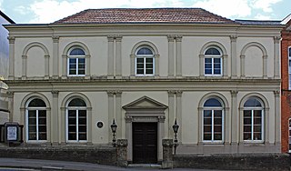
Taunton Unitarian Chapel is on Mary Street, Taunton, Somerset, England. It was built in the early 18th century as a Baptist chapel, but later adopted Unitarianism. The exterior was extensively renovated in the 19th century in an Italianate style. The chapel has been designated as a Grade II* listed building.

The Guildhall is a town hall and community building in the town of Chard in the English county of Somerset.
Chapel House is a Grade II listed building in Plympton, Devon, England. Standing at 10a and 10b Fore Street, Plympton's main street, it is believed to have originally been a town house, later developed into a shop with attached house. It dates to the mid-18th century, but contains older remnants.
Tan Cottage is a Grade II listed building in Plympton, Devon, England. It stands in Plympton's main street at 49 Fore Street, behind numbers 45 and 47, and dates mainly to the 17th century, when it was used as a tannery.

The Pent House is a Grade II listed building in Plympton, Devon, England. Standing at 20 Fore Street, Plympton's main street, it dates to the 17th century and is believed to have originally been merchants' houses or tenements of cottages. It is now one property.
24 Fore Street is a Grade II listed building in Plympton, Devon, England. Standing on Plympton's main street, it dates to the late 18th century.

