
Carrsville is a home rule-class city beside the Ohio River in Livingston County, Kentucky, in the United States. The population was 50 at the 2010 census, declining from 64 as of 2000. It is part of the Paducah, KY-IL Metropolitan Statistical Area. It is situated just west of the junction of where Buck Creek empties into the Ohio River.

Thomson was a city in Carlton County, Minnesota, United States, located along the Saint Louis River. The population was 159 at the 2010 census.

Gantt is a census-designated place (CDP) in Greenville County, South Carolina, United States. The population was 14,229 at the 2010 census. It is part of the Greenville–Mauldin–Easley Metropolitan Statistical Area and a suburb of the city of Greenville.

Virgilina is a town in Halifax County, Virginia, United States. The population was 154 at the 2010 census. Virgilina was once a copper mining town. It was a stop on the Atlantic and Danville Railway as recently as the 1950s. It is named "Virgilina" because it is located on the Virginia and North Carolina border.

San Agustín is a sea resort on the south coast of the island of Gran Canaria, Canary Islands, Spain. It is part of Maspalomas, in the municipality of San Bartolomé de Tirajana. The GC-1 motorway connects it with the airport and the province capital Las Palmas.

Sakar Peak is a peak of elevation 355 m in Vidin Heights on Varna Peninsula, Livingston Island in the South Shetland Islands, Antarctica. Partly ice-free southeast slopes. Surmounting Panega Glacier to the north and east, and the lower course of Kaliakra Glacier to the south.
The Trial Islands Ecological Reserve is a nature reserve on the Trial Islands in the British Columbia province of Canada just off the southern tip of Oak Bay in the Strait of Juan de Fuca. The twenty-three-hectare ecological reserve was established in 1990 to protect two elongated rocky islands and associated islets. It protects the greatest number of endangered and vulnerable species in a single ecological reserve in British Columbia.

Sandford is an unincorporated community in Fayette Township, Vigo County, in the U.S. state of Indiana. The community is part of the Terre Haute Metropolitan Statistical Area. A small portion of Sandford, now known as West Sandford or “Stringtown”, is in Illinois.
Gakgatla is a village in Kweneng District of Botswana. The village is located around 40 km north-west of the capital of Botswana, Gaborone. The population of Gakgatla was 211 in 2001 census.
Self is an unincorporated community in Boone County, Arkansas, United States. It is the location of Cottonwood School No. 45, which is located at Cottonwood and Dubuque Roads and is listed on the National Register of Historic Places.
The Trap Rock River is a 19.8-mile-long (31.9 km) tributary of Torch Lake that flows through Keweenaw and Houghton counties in the Upper Peninsula of Michigan in the United States.
Grouse Creek in Humboldt County, California is a tributary on the west bank of the South Fork of the Trinity River. Its basin lies approximately 20–25 miles east of Eureka, California.
Fall Creek is a master-planned community in unincorporated Harris County, Texas, United States. The 1,300 acres (530 ha) community is 3 miles (4.8 km) away from George Bush Intercontinental Airport in Houston and 15 miles (24 km) away from Downtown Houston. Fall Creek was developed by Johnson Development and Jefferson Development.
Podovi is a village in the Municipality of Drvar, Canton 10 of the Federation of Bosnia and Herzegovina, an entity of Bosnia and Herzegovina.
Colville Air Force Station is a closed United States Air Force General Surveillance Radar station. It is located 14.7 miles (23.7 km) east-northeast of Colville, Washington. It was closed in 1961.
Bellamy is an unincorporated community in Gloucester County, in the U. S. state of Virginia.
Jugovići is a village situated in Loznica municipality in Serbia.
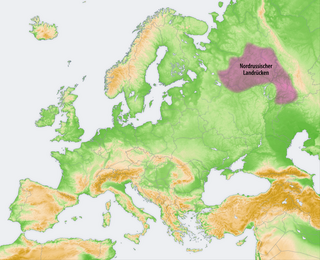
The Northern Ridge, Northern Uvaly, Severnyye Uvaly, is the chain of hills in the northern part of the East European Plain in Russia. The Northern Ridge divides the river basins of the Northern Dvina River (north) and the Volga River (south). The chain is located roughly in the west–east direction, between the source of the Kostroma River and the sources of the Vychegda River and the Kama River. The Northern Ridge is approximately 200 km long. Roughly, the chain is limited from the north by the valleys of the Sukhona and the Vychegda, and from the south by the course of the Volga in the west and by the course of the Kama in the east.

Batil Spur is the rocky ridge extending 3.9 km and 1.3 km wide, forming the southeast extremity of Flowers Hills on the east side of Sentinel Range in Ellsworth Mountains. It surmounts Rutford Ice Stream to the east and the ends of its tributaries flowing from Sikera Valley and Doyran Heights to the west.
White City is an unincorporated community in east central Stone County, Missouri, United States. White City is located on Missouri Route V, approximately 2.5 miles west of Ponce de Leon. The community is located on Goff Creek, about one half mile southeast of that stream's confluence with the James River.
