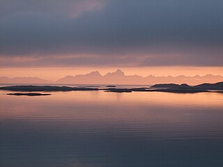
The Norwegian Sea is a marginal sea, grouped with either the Atlantic Ocean or the Arctic Ocean, northwest of Norway between the North Sea and the Greenland Sea, adjoining the Barents Sea to the northeast. In the southwest, it is separated from the Atlantic Ocean by a submarine ridge running between Iceland and the Faroe Islands. To the north, the Jan Mayen Ridge separates it from the Greenland Sea.

North Atlantic Deep Water (NADW) is a deep water mass formed in the North Atlantic Ocean. Thermohaline circulation of the world's oceans involves the flow of warm surface waters from the southern hemisphere into the North Atlantic. Water flowing northward becomes modified through evaporation and mixing with other water masses, leading to increased salinity. When this water reaches the North Atlantic, it cools and sinks through convection, due to its decreased temperature and increased salinity resulting in increased density. NADW is the outflow of this thick deep layer, which can be detected by its high salinity, high oxygen content, nutrient minima, high 14C/12C, and chlorofluorocarbons (CFCs).

An ocean current is a continuous, directed movement of seawater generated by a number of forces acting upon the water, including wind, the Coriolis effect, breaking waves, cabbeling, and temperature and salinity differences. Depth contours, shoreline configurations, and interactions with other currents influence a current's direction and strength. Ocean currents are primarily horizontal water movements.

An oceanographic water mass is an identifiable body of water with a common formation history which has physical properties distinct from surrounding water. Properties include temperature, salinity, chemical - isotopic ratios, and other physical quantities which are conservative flow tracers. Water mass is also identified by its non-conservative flow tracers such as silicate, nitrate, oxygen, and phosphate.

The East Greenland Current (EGC) is a cold, low-salinity current that extends from Fram Strait (~80N) to Cape Farewell (~60N). The current is located off the eastern coast of Greenland along the Greenland continental margin. The current cuts through the Nordic Seas and through the Denmark Strait. The current is of major importance because it directly connects the Arctic to the Northern Atlantic, it is a major contributor to sea ice export out of the Arctic, and it is a major freshwater sink for the Arctic.

The Greenland Sea is a body of water that borders Greenland to the west, the Svalbard archipelago to the east, Fram Strait and the Arctic Ocean to the north, and the Norwegian Sea and Iceland to the south. The Greenland Sea is often defined as part of the Arctic Ocean, sometimes as part of the Atlantic Ocean. However, definitions of the Arctic Ocean and its seas tend to be imprecise or arbitrary. In general usage the term "Arctic Ocean" would exclude the Greenland Sea. In oceanographic studies the Greenland Sea is considered part of the Nordic Seas, along with the Norwegian Sea. The Nordic Seas are the main connection between the Arctic and Atlantic oceans and, as such, could be of great significance in a possible shutdown of thermohaline circulation. In oceanography the Arctic Ocean and Nordic Seas are often referred to collectively as the "Arctic Mediterranean Sea", a marginal sea of the Atlantic.

The Norwegian Current is one of two dominant arctic inflows of water. It can be traced from near Shetland, north of Scotland, otherwise from the eastern North Sea at depths of up to 100 metres. It finally passes the opening into the Barents Sea, a large outcrop of the Arctic Ocean. Compared to its partial source the North Atlantic Current it is colder and less salty; the other sources are the less saline North and Baltic seas and the Norwegian fjords and rivers. It is considerably warmer and saltier than the Arctic Ocean, which is freshened by precipitation and ice in and around it. Winter temperatures in the flow are typically between 2 and 5 °C — the co-parent North Atlantic flow, a heat remnant of its Gulf Stream chief contributor, exceeds 6 °C.
Bottom water is the lowermost water mass in a water body, by its bottom, with distinct characteristics, in terms of physics, chemistry, and ecology.

The Arctic Ocean is the smallest and shallowest of the world's five oceanic divisions. It spans an area of approximately 14,060,000 km2 (5,430,000 sq mi) and is known as one of the coldest of oceans. The International Hydrographic Organization (IHO) recognizes it as an ocean, although some oceanographers call it the Arctic Mediterranean Sea. It has also been described as an estuary of the Atlantic Ocean. It is also seen as the northernmost part of the all-encompassing world ocean.

The Fram Strait is the passage between Greenland and Svalbard, located roughly between 77°N and 81°N latitudes and centered on the prime meridian. The Greenland and Norwegian Seas lie south of Fram Strait, while the Nansen Basin of the Arctic Ocean lies to the north. Fram Strait is noted for being the only deep connection between the Arctic Ocean and the World Oceans. The dominant oceanographic features of the region are the West Spitsbergen Current on the east side of the strait and the East Greenland Current on the west.
Antarctic Intermediate Water (AAIW) is a cold, relatively low salinity water mass found mostly at intermediate depths in the Southern Ocean. The AAIW is formed at the ocean surface in the Antarctic Convergence zone or more commonly called the Antarctic Polar Front zone. This convergence zone is normally located between 50°S and 60°S, hence this is where almost all of the AAIW is formed.

The West Spitsbergen Current (WSC) is a warm, salty current that runs poleward just west of Spitsbergen,, in the Arctic Ocean. The WSC branches off the Norwegian Atlantic Current in the Norwegian Sea. The WSC is of importance because it drives warm and salty Atlantic Water into the interior Arctic. The warm and salty WSC flows north through the eastern side of Fram Strait, while the East Greenland Current (EGC) flows south through the western side of Fram Strait. The EGC is characterized by being very cold and low in salinity, but above all else it is a major exporter of Arctic sea ice. Thus, the EGC combined with the warm WSC makes the Fram Strait the northernmost ocean area having ice-free conditions throughout the year in all of the global ocean.
The Great Salinity Anomaly (GSA) originally referred to an event in the late 1960s to early 1970s where a large influx of freshwater from the Arctic Ocean led to a salinity anomaly in the northern North Atlantic Ocean, which affected the Atlantic meridional overturning circulation. Since then, the term "Great Salinity Anomaly" has been applied to successive occurrences of the same phenomenon, including the Great Salinity Anomaly of the 1980s and the Great Salinity Anomaly of the 1990s. The Great Salinity Anomalies were advective events, propagating to different sea basins and areas of the North Atlantic, and is on the decadal-scale for the anomalies in the 1970s, 1980s, and 1990s.
The East Iceland Current (EIC) is a cold water ocean current that forms east of Greenland at 72°N, 11°W as a branch of the East Greenland Current that merges with the Irminger Current flowing southward until it meets the northeast part of Iceland. It quickly rotates in a counterclockwise direction and flows eastward along the Iceland-Faeroe Ridge before turning north and flowing into the Norwegian Sea. The EIC flows at an average rate of 6 centimeters per second, with a maximum velocity of 10 centimeters per second occurring as the current turns eastward.
The Arctic Intermediate Water (AIW) is a water mass found between the top cold, relatively fresh polar water and the bottom deep water in the Arctic domain. AIW is formed in small quantities compared to other water masses, and has limited influence outside of the Arctic domain.
Labrador Sea Water is an intermediate water mass characterized by cold water, relatively low salinity compared to other intermediate water masses, and high concentrations of both oxygen and anthropogenic tracers. It is formed by convective processes in the Labrador Sea located between Greenland and the northeast coast of the Labrador Peninsula. Deep convection in the Labrador Sea allows colder water to sink forming this water mass, which is a contributor to the upper layer of North Atlantic Deep Water. North Atlantic Deep Water flowing southward is integral to the Atlantic Meridional Overturning Circulation. The Labrador Sea experiences a net heat loss to the atmosphere annually.

The Arctic ice pack is the sea ice cover of the Arctic Ocean and its vicinity. The Arctic ice pack undergoes a regular seasonal cycle in which ice melts in spring and summer, reaches a minimum around mid-September, then increases during fall and winter. Summer ice cover in the Arctic is about 50% of winter cover. Some of the ice survives from one year to the next. Currently, 28% of Arctic basin sea ice is multi-year ice, thicker than seasonal ice: up to 3–4 m (9.8–13.1 ft) thick over large areas, with ridges up to 20 m (65.6 ft) thick. Besides the regular seasonal cycle there has been an underlying trend of declining sea ice in the Arctic in recent decades as well.
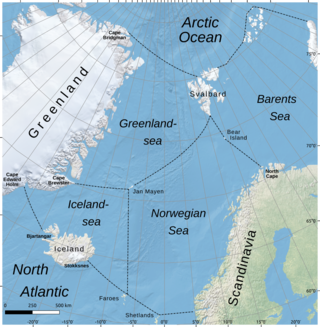
The Iceland Sea, a relatively small body of water, is bounded by Iceland. It is characterized by its proximity to the Mid-Atlantic Ridge, which transforms into the Kolbeinsey Ridge, and the Greenland-Scotland Ridge, and it lies just south of the Arctic Circle. This region is typically delineated by Greenland to the west, the Denmark Strait, and the continental shelf break south of Iceland to the south. Next in the boundary line are Jan Mayen, being a small Norwegian volcanic island, and the Jan Mayen Fracture Zone to the north, with the Jan Mayen Ridge to the east of the sea. This ridge serves as the northern boundary of the Iceland Sea, acting as the dividing line from the Greenland Sea. To the immediate south of Jan Mayen, the Iceland-Jan Mayen Ridge stretches towards the Iceland-Faroe Ridge, creating a boundary between the Iceland Sea and the Norwegian Sea to the east.

Cecilie Mauritzen is a Norwegian physical oceanographer who studies connections between ocean currents and climate change.

Cold and dense water from the Nordic Seas is transported southwards as Faroe-Bank Channel overflow. This water flows from the Arctic Ocean into the North Atlantic through the Faroe-Bank Channel between the Faroe Islands and Scotland. The overflow transport is estimated to contribute to one-third of the total overflow over the Greenland-Scotland Ridge. The remaining two-third of overflow water passes through Denmark Strait, the Wyville Thomson Ridge (0.3 Sv), and the Iceland-Faroe Ridge (1.1 Sv).
