Faroe-Bank Channel overflow

Last updated
Location of Faroe-Bank Channel, indicating the two different directions of Faroe-Bank Channel overflow. Data retrieved from ETOPO. Faroe-Bank Channel overflow.jpg
Location of Faroe-Bank Channel, indicating the two different directions of Faroe-Bank Channel overflow. Data retrieved from ETOPO.

Cold and dense water from the Nordic Seas is transported southwards as Faroe-Bank Channel overflow. This water flows from the Arctic Ocean into the North Atlantic through the Faroe-Bank Channel between the Faroe Islands and Scotland. The overflow transport is estimated to contribute to one-third (2.1±0.2  Sv, on average) of the total overflow over the Greenland-Scotland Ridge. [1] [2] The remaining two-third of overflow water passes through Denmark Strait (being the strongest overflow branch with an estimated transport of 3.5 Sv [3] [4] ), the Wyville Thomson Ridge (0.3 Sv), and the Iceland-Faroe Ridge (1.1 Sv). [1]

Contents

Faroe-Bank Channel overflow (FBCO) contributes to a large extent to the formation of North Atlantic Deep Water. [5] Therefore, FBCO is important for water transport towards the deep parts of the North Atlantic, playing a significant role in Earth's climate system. [6]

Faroe-Bank Channel

The Faroe-Bank Channel (FBC) is a deeply eroded channel in the Greenland-Scotland Ridge (GSR). Its primary sill, located south of the Faroe Islands, has a width of about 15 km and a maximum depth of 840 m, with very steep walls at both sides of the channel. 100 km north-west of this sill, there is a secondary sill with a maximum depth of 850 m. [7] Faroe-Bank Channel overflow enters the FBC from the northeast, turns towards the west between the Faroe Islands and the Faroe Bank, and leaves the GSR in southwestern direction, west-southwest of the Faroe Islands. [7]

Hydrography

Temperature, salinity (both 2019 vessel cruise measurements) and current speed (2019 ADCP ensemble) profiles, and overflow transport (daily averages since 1996) for the part of the Faroe-Bank Channel where the overflow takes place. Data retrieved from ENVOFAR. FBCO properties.png
Temperature, salinity (both 2019 vessel cruise measurements) and current speed (2019 ADCP ensemble) profiles, and overflow transport (daily averages since 1996) for the part of the Faroe-Bank Channel where the overflow takes place. Data retrieved from ENVOFAR.

The water flowing over the Greenland-Scotland Ridge through the Faroe-Bank Channel consists of a very well-mixed bottom layer, with a stratified water layer on top. [8] The temperature of this stratified layer can get to 11 °C in the upper 100 m of the channel, with a salinity around 35.1 g/kg; between 100 and 400 m depth the temperature of the water in the stratified layer is around 8 °C, with a salinity of 35.2 g/kg. [8] The water below 400 m, in the well-mixed layer, can be characterised as overflow water.

Definition of overflow

The mixed bottom layer of the FBC is where the actual overflow takes place, being fed by inflow of cold and fresh North Atlantic Water, Modified North Atlantic Water, Norwegian Sea Deep Water and Norwegian Sea Arctic Intermediate Water. [9] These water masses have different temperatures (between -0.5 and 7.0 °C) and salinities (between 34.7 and 35.4 g/kg). [9] Therefore, it may be complicated to exactly define which water entering the FBC contributes to the actual overflow. Four definitions are possible, two of which depending on the overflow velocity, one depending on the overflow flux, and one depending on the overflow water properties.

The simplest definition is in terms of velocities: water with a velocity in northwestern direction is then termed Faroe-Bank Channel overflow. [1] At the sill, velocities can grow up until 1.2 m/s, accelerating when flowing downwards the deepening bathymetry. [9] In this respect, high velocities are associated with strong mixing and highly turbulent flows. In the stratified layer at the top of the channel, velocities become negative (i.e., in southeastern direction), which makes these water no part of the overflow.

Another option is to take into account the barotropic (i.e., horizontal sea-surface height gradients determine currents) and baroclinic (i.e., horizontal density gradients determine currents) pressure gradients at the overflow depth between both sides of the GSR:

where is the decrease in sea-surface height and is the decrease in interface height from upstream areas to the sill. [10] Processes like mixing, circulation and convection contribute to these pressure gradients. The overflow velocity, then, scales as follows with the pressure gradient between the basins north and south of the ridge:

This velocity can then be used to define the total overflow flux in the FBC. [11] A third definition is so-called kinematic overflow: the water flux from the bottom of the channel up to the interface height, being the level where the velocity in northwestern direction measures one half of the maximum velocity in the profile. [10] The overflow flux is then calculated through

where is the average profile velocity, is the interface height, is the height of the layer below the lowest measurement station in the channel, and is the volume flux per unit width of the channel. [10]

Lastly, overflow can also be defined on the basis of hydrographical properties: namely as water that flows through the FBC having a temperature lower than 3 °C, [10] or having a potential density higher than 27.8 kg/m3. [12] This definition is most often used when estimating values for the magnitude of the FBCO.

Periodicity

Temperature and salinity profiles as well as current speeds in the FBC vary strongly on a day-to-day basis. The dense water forms domes that move through the channel with a period of 2.5 to 6 days. [2] At the ocean surface, this periodicity can be observed in the form of topographic Rossby waves at the sea surface, which are caused by mesoscale oscillations in the velocity field. [13] The resulting eddies are the consequence of baroclinic instabilities within the overflow water, which then induce the observed periodicity. [14]

On a greater timescale, atmospheric forcing also causes periodic changes in the FBCO. When the atmospheric circulation governing the Nordic Seas is in a cyclonic (anticyclonic) regime, the source of the deep water predominantly comes via a western (eastern) inflow path, and the FBCO will be weaker (stronger). [5] The eastern inflow path is called the Faroe-Strait Channel Jet. This transition from a cyclonic to an anticyclonic regime takes place on an interannual timescale, but the atmospheric forcing also shows a seasonal cycle. During summer the weakened cyclonic winds are associated with a higher FBCO transport. This indicates a fast barotropic response to the wind forcing. [5]

Outflow

Faroe-Strait Channel Jet water is much colder than the water flowing into the Faroe-Bank Channel via its western entrance path. Within the FBC, water always flows along its eastern rather than its western boundary, regardless the different inflow pathways from the Nordic Seas. [5] Moreover, at times the eastern inflow path is dominant, overflow waters are denser and higher in volume.

After passing the primary Faroe-Bank Channel sill, the overflow bifurcates into two different branches that both flow with a maximum velocity of 1.35 m/s on top of each other. The average thickness of the total outflow plume along its descent is 160±70 m, showing a high lateral variability, and yields a transport of ~1 Sv per branch. [15] A transverse circulation actively dilutes the bottom branch of the plume. The shallow, intermediate branch transports warmer, less dense outflow water along the ridge slope towards the west. This branch mixes with oxygen-poor, fresh Modified East Icelandic Water. [16] The deep (deeper than 1000 m) branch transports the most dense, cold water towards the deep parts of the North Atlantic. [17] This branch entrains warmer and more saline water, mixes, and consequently obtains higher temperatures and salinity. Both branches ultimately contribute to the formation of North Atlantic Deep Water.

North Atlantic overturning

The Atlantic meridional overturning circulation (AMOC) is important for Earth's climate because of its distribution of heat and salinity over the globe. [5] The strength of the Faroe-Bank Channel overflow is an important indicator for the stability of the AMOC, since the overflow produces dense waters that contribute for a large extent to the total overturning in the North Atlantic. [5] Parameters that can effect the AMOC are kinematic overflow (i.e., the magnitude of the overflow transport) and overflow density (as the AMOC being a density-driven circulation). In this respect, density characteristics of the overflow could vary even if the kinematic overflow does not. [10]

Measurements

From 1995 onwards, FBCO has been monitored by a continuous Acoustic Doppler current profiler (ADCP) mooring, measuring volume transport, hydrographic properties and the density of the overflow. [17] The kinematic overflow, derived from the velocity field, showed a non-significant positive linear trend of 0.01±0.013 Sv/yr between 1995 and 2015, whereas the coldest part of the FBCO warmed in that same period with 0.1±0.06 °C (which made density decrease), causing increasing transport of heat into the AMOC. [18] This warming, however, is accompanied by an observed salinity (and therefore density) increase, which results in no net change in density. [18]

Model simulations

Climate models have shown an overall decreasing trend in the baroclinic component of the overflow between 1948 and 2005; the barotropic pressure gradient, however, shows an increasing trend of equal magnitude. These processes compensate each other; as a result the pressure difference at depth does not show a significant trend over time. [11]

Global inverse modelling, ocean hydrographic surveys, chlorofuorocarbon (CFC) inventories, and monitoring of the AMOC from 2004 to present have shown that the AMOC has slowed down in the past decades. [6] As explained, density of FBCO waters did not significantly change in that time period, so changes in FBCO cannot (fully) explain the changes in the AMOC. [19]

See also

Related Research Articles

<span class="mw-page-title-main">Atlantic Ocean</span> Ocean between Europe, Africa and the Americas

The Atlantic Ocean is the second-largest of the world's five oceans, with an area of about 85,133,000 km2 (32,870,000 sq mi). It covers approximately 17% of Earth's surface and about 24% of its water surface area. It is known to separate the "Old World" of Africa, Europe, and Asia from the "New World" of the Americas in the European perception.

<span class="mw-page-title-main">North Atlantic Deep Water</span> Deep water mass formed in the North Atlantic Ocean

North Atlantic Deep Water (NADW) is a deep water mass formed in the North Atlantic Ocean. Thermohaline circulation of the world's oceans involves the flow of warm surface waters from the southern hemisphere into the North Atlantic. Water flowing northward becomes modified through evaporation and mixing with other water masses, leading to increased salinity. When this water reaches the North Atlantic it cools and sinks through convection, due to its decreased temperature and increased salinity resulting in increased density. NADW is the outflow of this thick deep layer, which can be detected by its high salinity, high oxygen content, nutrient minima, high 14C/12C, and chlorofluorocarbons (CFCs).

<span class="mw-page-title-main">Drake Passage</span> Body of water between South America and the South Shetland Islands of Antarctica

The Drake Passage is the body of water between South America's Cape Horn, Chile, Argentina and the South Shetland Islands of Antarctica. It connects the southwestern part of the Atlantic Ocean with the southeastern part of the Pacific Ocean and extends into the Southern Ocean. The passage is named after the 16th-century English explorer and privateer Sir Francis Drake.

<span class="mw-page-title-main">Physical oceanography</span> Study of physical conditions and processes within the ocean

Physical oceanography is the study of physical conditions and physical processes within the ocean, especially the motions and physical properties of ocean waters.

<span class="mw-page-title-main">Thermohaline circulation</span> Part of large-scale ocean circulation

Thermohaline circulation (THC) is a part of the large-scale ocean circulation that is driven by global density gradients created by surface heat and freshwater fluxes. The adjective thermohaline derives from thermo- referring to temperature and -haline referring to salt content, factors which together determine the density of sea water. Wind-driven surface currents travel polewards from the equatorial Atlantic Ocean, cooling en route, and eventually sinking at high latitudes. This dense water then flows into the ocean basins. While the bulk of it upwells in the Southern Ocean, the oldest waters upwell in the North Pacific. Extensive mixing therefore takes place between the ocean basins, reducing differences between them and making the Earth's oceans a global system. The water in these circuits transport both energy and mass around the globe. As such, the state of the circulation has a large impact on the climate of the Earth.

<span class="mw-page-title-main">East Greenland Current</span> Current from Fram Strait to Cape Farewell off the eastern coat of Greenland

The East Greenland Current (EGC) is a cold, low-salinity current that extends from Fram Strait (~80N) to Cape Farewell (~60N). The current is located off the eastern coast of Greenland along the Greenland continental margin. The current cuts through the Nordic Seas and through the Denmark Strait. The current is of major importance because it directly connects the Arctic to the Northern Atlantic, it is a major contributor to sea ice export out of the Arctic, and it is a major freshwater sink for the Arctic.

<span class="mw-page-title-main">Strait of Sicily</span> The strait between Sicily and Tunisia

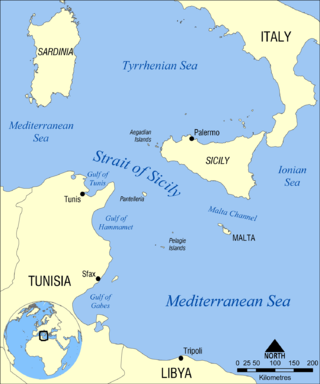
The Strait of Sicily is the strait between Sicily and Tunisia. The strait is about 145 kilometres (90 mi) wide and divides the Tyrrhenian Sea and the western Mediterranean Sea, from the eastern Mediterranean Sea. The maximum depth is 316 meters (1,037 ft). The island of Pantelleria lies in the middle of the strait.

<span class="mw-page-title-main">Atlantic meridional overturning circulation</span> System of surface and deep currents in the Atlantic Ocean

The Atlantic meridional overturning circulation (AMOC) is part of a global thermohaline circulation in the oceans and is the zonally integrated component of surface and deep currents in the Atlantic Ocean. It is characterized by a northward flow of warm, salty water in the upper layers of the Atlantic, and a southward flow of colder, deep waters. These "limbs" are linked by regions of overturning in the Nordic and Labrador Seas and the Southern Ocean, although the extent of overturning in the Labrador Sea is disputed. The AMOC is an important component of the Earth's climate system, and is a result of both atmospheric and thermohaline drivers.

<span class="mw-page-title-main">Arctic Ocean</span> Ocean in the north polar region

The Arctic Ocean is the smallest and shallowest of the world's five major oceans. It spans an area of approximately 14,060,000 km2 (5,430,000 sq mi) and is known as one of the coldest of oceans. The International Hydrographic Organization (IHO) recognizes it as an ocean, although some oceanographers call it the Arctic Mediterranean Sea. It has also been described as an estuary of the Atlantic Ocean. It is also seen as the northernmost part of the all-encompassing World Ocean.

<span class="mw-page-title-main">Double diffusive convection</span> Convection with two density gradients

Double diffusive convection is a fluid dynamics phenomenon that describes a form of convection driven by two different density gradients, which have different rates of diffusion.

<span class="mw-page-title-main">West Spitsbergen Current</span> Warm, salty current that runs poleward just west of Spitsbergen

The West Spitsbergen Current (WSC) is a warm, salty current that runs poleward just west of Spitsbergen,, in the Arctic Ocean. The WSC branches off the Norwegian Atlantic Current in the Norwegian Sea. The WSC is of importance because it drives warm and salty Atlantic Water into the interior Arctic. The warm and salty WSC flows north through the eastern side of Fram Strait, while the East Greenland Current (EGC) flows south through the western side of Fram Strait. The EGC is characterized by being very cold and low in salinity, but above all else it is a major exporter of Arctic sea ice. Thus, the EGC combined with the warm WSC makes the Fram Strait the northernmost ocean area having ice-free conditions throughout the year in all of the global ocean.

The Great Salinity Anomaly (GSA) originally referred to an event in the late 1960s to early 1970s where a large influx of freshwater from the Arctic Ocean led to a salinity anomaly in the northern North Atlantic Ocean, which affected the Atlantic meridional overturning circulation. Since then, the term "Great Salinity Anomaly" has been applied to successive occurrences of the same phenomenon, including the Great Salinity Anomaly of the 1980s and the Great Salinity Anomaly of the 1990s. The Great Salinity Anomalies were advective events, propagating to different sea basins and areas of the North Atlantic, and is on the decadal-scale for the anomalies in the 1970s, 1980s, and 1990s.

The East Iceland Current (EIC) is a cold water ocean current that forms east of Greenland at 72°N, 11°W as a branch of the East Greenland Current that merges with the Irminger Current flowing southward until it meets the northeast part of Iceland. It quickly rotates in a counterclockwise direction and flows eastward along the Iceland-Faeroe Ridge before turning north and flowing into the Norwegian Sea. The EIC flows at an average rate of 6 centimeters per second, with a maximum velocity of 10 centimeters per second occurring as the current turns eastward.

<span class="mw-page-title-main">Mode water</span> Type of water mass which is nearly vertically homogeneous

Mode water is defined as a particular type of water mass, which is nearly vertically homogeneous. Its vertical homogeneity is caused by the deep vertical convection in winter. The first term to describe this phenomenon is 18° water, which was used by Valentine Worthington to describe the isothermal layer in the northern Sargasso Sea cool to a temperature of about 18 °C each winter. Then Masuzawa introduced the subtropical mode water concept to describe the thick layer of temperature 16–18 °C in the northwestern North Pacific subtropical gyre, on the southern side of the Kuroshio Extension. The terminology mode water was extended to the thick near-surface layer north of the Subantarctic Front by McCartney, who identified and mapped the properties of the Subantarctic mode water (SAMW). After that, McCartney and Talley then applied the term subpolar mode water (SPMW) to the thick near-surface mixed layers in the North Atlantic’s subpolar gyre.

<span class="mw-page-title-main">Nordic Seas</span>

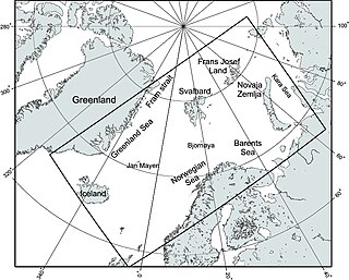
The Nordic Seas are located north of Iceland and south of Svalbard. They have also been defined as the region located north of the Greenland-Scotland Ridge and south of the Fram Strait-Spitsbergen-Norway intersection. Known to connect the North Pacific and the North Atlantic waters, this region is also known as having some of the densest waters, creating the densest region found in the North Atlantic Deep Water. The deepest waters of the Arctic Ocean are connected to the worlds other oceans through Nordic Seas and Fram Strait. There are three seas within the Nordic Sea: Greenland Sea, Norwegian Sea, and Iceland Sea. The Nordic Seas only make up about 0.75% of the World's Oceans. This region is known as having diverse features in such a small topographic area, such as the mid oceanic ridge systems. Some locations have shallow shelves, while others have deep slopes and basins. This region, because of the atmosphere-ocean transfer of energy and gases, has varying seasonal climate. During the winter, sea ice is formed in the western and northern regions of the Nordic Seas, whereas during the summer months, the majority of the region remains free of ice.

The Atlantic meridional overturning circulation (AMOC) is a large system of ocean currents, like a conveyor belt. It is driven by differences in temperature and salt content and it is an important component of the climate system. However, the AMOC is not a static feature of global circulation. It is sensitive to changes in temperature, salinity and atmospheric forcings. Climate reconstructions from δ18O proxies from Greenland reveal an abrupt transition in global temperature about every 1470 years. These changes may be due to changes in ocean circulation, which suggests that there are two equilibria possible in the AMOC. Stommel made a two-box model in 1961 which showed two different states of the AMOC are possible on a single hemisphere. Stommel’s result with an ocean box model has initiated studies using three dimensional ocean circulation models, confirming the existence of multiple equilibria in the AMOC.

Thermohaline staircases are patterns that form in oceans and other bodies of salt water, characterised by step-like structures observed in vertical temperature and salinity profiles; the patterns are formed and maintained by double diffusion of heat and salt. The ocean phenomenon consists of well-mixed layers of ocean water stacked on top of each other. The well-mixed layers are separated by high-gradient interfaces, which can be several meters thick. The total thickness of staircases ranges typically from tens to hundreds of meters.

The Agulhas Leakage is an inflow of anomalously warm and saline water from the Indian Ocean into the South Atlantic due to the limited latitudinal extent of the African continent compared to the southern extension of the subtropical super gyre in the Indian Ocean. The process occurs during the retroflection of the Agulhas Current via shedding of anticyclonic Agulhas Rings, cyclonic eddies and direct inflow. The leakage contributes to the Atlantic Meridional Overturning Circulation (AMOC) by supplying its upper limb, which has direct climate implications.

<span class="mw-page-title-main">North Brazil Current Retroflection</span> Ocean current retroflection phenomenon

The North Brazil Current (NBC) retroflects north-eastwards and merges into the North Equatorial Counter Current (NECC). The retroflection occurs in a seasonal pattern when there is strong retroflection from late summer to early winter. There is weakened or no retroflection during other times of the year. Just like in the Agulhas Current, the retroflection also sheds some eddies that make their way to the Caribbean Sea through the Lesser Antilles.

<span class="mw-page-title-main">Lofoten Vortex</span> Physical oceanographic feature

The Lofoten Vortex, also called Lofoten Basin Vortex or Lofoten Basin Eddy, is a permanent oceanic anticyclonic eddy, located in the northern part of the Norwegian Sea, off the coast of the Lofoten archipelago. It was documented for the first time in the 1970s.

References

  1. 1 2 3 Østerhus, Svein; Sherwin, Toby; Quadfasel, Detlef; Hansen, Bogi (2008), "The Overflow Transport East of Iceland", Arctic–Subarctic Ocean Fluxes, Dordrecht: Springer Netherlands, pp. 427–441, doi:10.1007/978-1-4020-6774-7_19, ISBN   978-1-4020-6773-0 , retrieved 2022-03-19
  2. 1 2 Ullgren, J. E.; Darelius, E.; Fer, I. (2015-10-07). "Volume transport and mixing of the Faroe Bank Channel overflow from one year of moored measurements". Ocean Science Discussions. 12 (5): 2315. Bibcode:2015OcScD..12.2315U. doi: 10.5194/osd-12-2315-2015 .
  3. Jochumsen, Kerstin; Quadfasel, Detlef; Valdimarsson, Heðinn; Jónsson, Steingrímur (December 2012). "Variability of the Denmark Strait overflow: Moored time series from 1996-2011". Journal of Geophysical Research: Oceans. 117 (C12): n/a. Bibcode:2012JGRC..11712003J. doi: 10.1029/2012jc008244 . ISSN   0148-0227.
  4. Harden, B.E.; Pickart, R.S.; Valdimarsson, Héðinn; Våge, Kjetil; de Steur, Laura; Richards, Clark; Bahr, Frank; Torres, Dan; Børve, Eli; Jónsson, Steingrímur; Macrander, Andreas (June 2016). "Upstream sources of the Denmark Strait Overflow: Observations from a high-resolution mooring array". Deep Sea Research Part I: Oceanographic Research Papers. 112: 94–112. Bibcode:2016DSRI..112...94H. doi:10.1016/j.dsr.2016.02.007. hdl: 1956/16720 . ISSN   0967-0637.
  5. 1 2 3 4 5 6 Barbara, Chafik, Léon Hátún, Hjálmar Kjellsson, Joakim Larsen, Karin Margretha H. Rossby, Thomas Berx (2020-07-24). Discovery of an unrecognized pathway carrying overflow waters toward the Faroe Bank Channel. Nature Research. OCLC   1286412816.{{cite book}}: CS1 maint: multiple names: authors list (link)
  6. 1 2 Cheng, Wei; Chiang, John C. H.; Zhang, Dongxiao (15 September 2013). "Atlantic Mericional Overturning Circulation (AMOC) in CMIP5 Models: RCP and Historical Simulations". Journal of Climate. 26 (18): 7187–7197. Bibcode:2013JCli...26.7187C. doi: 10.1175/JCLI-D-12-00496.1 . S2CID   56001197.
  7. 1 2 Beaird, Nicholas; Fer, Ilker; Rhines, Peter; Eriksen, Charles (2012-12-01). "Dissipation of Turbulent Kinetic Energy Inferred from Seagliders: An Application to the Eastern Nordic Seas Overflows". Journal of Physical Oceanography. 42 (12): 2268–2282. Bibcode:2012JPO....42.2268B. doi: 10.1175/jpo-d-12-094.1 . hdl: 1956/16275 . ISSN   0022-3670.
  8. 1 2 Fer, Ilker; Voet, Gunnar; Seim, Knut S.; Rudels, Bert; Latarius, Katrin (January 2010). "Intense mixing of the Faroe Bank Channel overflow". Geophysical Research Letters. 37 (2): n/a. Bibcode:2010GeoRL..37.2604F. doi:10.1029/2009gl041924. ISSN   0094-8276. S2CID   129748007.
  9. 1 2 3 Borenäs, Karin; Lundberg, Peter (2004-02-01). "The Faroe-Bank Channel deep-water overflow". Deep Sea Research Part II: Topical Studies in Oceanography. The Physical Oceanography of Sea Straits. 51 (4): 335–350. Bibcode:2004DSRII..51..335B. doi:10.1016/j.dsr2.2003.05.002. ISSN   0967-0645.
  10. 1 2 3 4 5 Hansen, Bogi; Østerhus, Svein (December 2007). "Faroe Bank Channel overflow 1995–2005". Progress in Oceanography. 75 (4): 817–856. Bibcode:2007PrOce..75..817H. doi:10.1016/j.pocean.2007.09.004. ISSN   0079-6611.
  11. 1 2 Olsen, Steffen M.; Hansen, Bogi; Quadfasel, Detlef; Østerhus, Svein (September 2008). "Observed and modelled stability of overflow across the Greenland–Scotland ridge". Nature. 455 (7212): 519–522. Bibcode:2008Natur.455..519O. doi:10.1038/nature07302. ISSN   0028-0836. PMID   18818655. S2CID   4383230.
  12. Huang, Jie; Pickart, Robert S.; Huang, Rui Xin; Lin, Peigen; Brakstad, Ailin; Xu, Fanghua (2020-10-23). "Sources and upstream pathways of the densest overflow water in the Nordic Seas". Nature Communications. 11 (1): 5389. Bibcode:2020NatCo..11.5389H. doi:10.1038/s41467-020-19050-y. ISSN   2041-1723. PMC   7584654 . PMID   33097701.
  13. Darelius, E.; Ullgren, J. E.; Fer, I. (2013-07-01). "Observations of Barotropic Oscillations and Their Influence on Mixing in the Faroe Bank Channel Overflow Region". Journal of Physical Oceanography. 43 (7): 1525–1532. Bibcode:2013JPO....43.1525D. doi: 10.1175/jpo-d-13-059.1 . hdl: 1956/13066 . ISSN   0022-3670.
  14. Guo, Chuncheng; Ilicak, Mehmet; Fer, Ilker; Darelius, Elin; Bentsen, Mats (2014-10-01). "Baroclinic Instability of the Faroe Bank Channel Overflow*". Journal of Physical Oceanography. 44 (10): 2698–2717. Bibcode:2014JPO....44.2698G. doi: 10.1175/jpo-d-14-0080.1 . ISSN   0022-3670. S2CID   129512851.
  15. Nicholas, Ullgren, Jenny E. Fer, Ilker Darelius, Elin Beaird (2014-04-09). Interaction of the Faroe Bank Channel overflow with Iceland Basin intermediate waters. John Wiley & Sons. OCLC   1130872761.{{cite book}}: CS1 maint: multiple names: authors list (link)
  16. Ullgren, Jenny E.; Fer, Ilker; Darelius, Elin; Beaird, Nicholas (January 2014). "Interaction of the Faroe Bank Channel overflow with Iceland Basin intermediate waters". Journal of Geophysical Research: Oceans. 119 (1): 228–240. Bibcode:2014JGRC..119..228U. doi:10.1002/2013jc009437. hdl: 1912/6540 . ISSN   2169-9275.
  17. 1 2 Beaird, N. L.; Rhines, P. B.; Eriksen, C. C. (2013-11-01). "Overflow Waters at the Iceland–Faroe Ridge Observed in Multiyear Seaglider Surveys". Journal of Physical Oceanography. 43 (11): 2334–2351. Bibcode:2013JPO....43.2334B. doi: 10.1175/jpo-d-13-029.1 . ISSN   0022-3670.
  18. 1 2 Hansen, Bogi; Húsgarð Larsen, Karin Margretha; Hátún, Hjálmar; Østerhus, Svein (2016-11-17). "A stable Faroe Bank Channel overflow 1995–2015". Ocean Science. 12 (6): 1205–1220. Bibcode:2016OcSci..12.1205H. doi: 10.5194/os-12-1205-2016 . ISSN   1812-0784.
  19. S.A., Bryden, H.L. Longworth, H.R. Cunningham (2005). Letter. Slowing of the Atlantic meridional overturning circulation at 25° N. OCLC   921259324.{{cite book}}: CS1 maint: multiple names: authors list (link)