Croxteth Hall is a country estate and Grade II* listed building in the West Derby suburb of Liverpool, England. It is the former country estate and ancestral home of the Molyneux family, the Earls of Sefton. After the death of the seventh and last Earl in 1972, the estate passed to Liverpool City Council, which now manages the remainder of the estate following the sale of approximately half of the grounds. The remaining grounds, Croxteth Park, were at one time a hunting chase of the Molyneux family and are now open to the public.

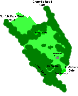
Sheffield Manor Lodge, also known as Sheffield Manor or locally as Manor Castle, is a lodge built about 1516 in what then was a large deer park southeast of Sheffield, South Yorkshire, England, to provide a country retreat and further accommodate George Talbot, the 4th Earl of Shrewsbury, and his large family. The remnant of this estate is now known as Norfolk Park. The housing estate of Manor is named after Sheffield Manor Lodge.

Lansdowne Park is a 40-acre (16 ha) urban park, historic sports, exhibition and entertainment facility in Ottawa, Ontario, Canada, owned by the City of Ottawa. It is located on Bank Street adjacent to the Rideau Canal in The Glebe neighbourhood of central Ottawa. Lansdowne Park contains the TD Place Stadium and Arena complex, the Aberdeen Pavilion, and the Horticulture Building.

Bishops' House is a half-timbered house in the Norton Lees district of the City of Sheffield, England. It was built c. 1500 and is located on the southern tip of Meersbrook Park. It is one of the three surviving timber-framed houses in the city.

Park & Arbourthorne ward—which includes the districts of Arbourthorne, Gleadless, and Norfolk Park—is one of the 28 electoral wards in City of Sheffield, England. It is located in the southeastern part of the city and covers an area of 1.74 square miles (4.5 km2). The population of this ward in 2001 was 17,500 people in 7,800 households. The ward population at the 2011 Census was 19,133. It is one of the five wards that form the Sheffield Heeley parliamentary constituency.
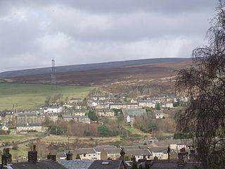
Tintwistle is a village and civil parish in the High Peak district of the non-metropolitan county of Derbyshire, England. Historically in Cheshire, according to the 2001 census the parish had a population of 1,401, reducing marginally to 1,400 and including Arnfield at the 2011 Census. The village is just north of Glossop at the lower end of Longdendale Valley. Tintwistle, like nearby Crowden and Woodhead, lies within the historic county boundaries of Cheshire.

Shepherd Wheel is a working museum in a former water-powered grinding workshop situated on the Porter Brook in the south-west of the City of Sheffield, England. One of the earliest wheels on the River Porter, it is one of the few remaining—and effectively complete—examples of this kind of enterprise, one that used to be commonplace in the Sheffield area. Its 5.5 m (18 ft) diameter overshot water wheel is powered from a large dam stocked with water diverted from the Porter Brook. The workshops, dam, goit and weir are Grade II listed, and the site is a Scheduled Ancient Monument.

Hasland is a suburb in the Borough of Chesterfield in the town of Chesterfield, Derbyshire, England. Hasland is located south of Spital, east of Birdholme and north of Grassmoor. Hasland is a ward of the Borough of Chesterfield. The ward population at the 2011 Census was 6,969. The A617 links Hasland, along with Chesterfield, to the M1.

Charles William Alcock was an English sportsman, administrator, author and editor. He was a major instigator in the development of both international football and cricket, as well as being the creator of the FA Cup.

Kippen is a village in west Stirlingshire, Scotland. It lies between the Gargunnock Hills and the Fintry Hills and overlooks the Carse of Forth to the north. The village is 9 miles west of Stirling and 20 mi (32 km) north of Glasgow. It is 4+1⁄2 mi (7 km) south-east of Loch Lomond and the Trossachs National Park, Scotland's first National Park.

The Arboretum is a city park in Nottingham, England.

The Cholera Monument is a memorial in Sheffield, England, to the victims of a cholera epidemic of 1832. Of the 402 victims of the disease 339 were buried in grounds between Park Hill and Norfolk Park adjoining Clay Wood. Money from the treasurers of the Board of Health was set aside for a monument for the site.

Endcliffe Park is a large park in the city of Sheffield, South Yorkshire, England. The park was opened in 1887 to commemorate the Jubilee of Queen Victoria. When travelling West from the city centre it is the first in a series of parks and green spaces, known collectively as the Porter Valley Parks, all of which lie along the course of the Porter Brook. The next park in the sequence is Bingham Park, separated from Endcliffe Park by Rustlings Road. In 1924 Patrick Abercrombie said of the parks, "The Porter Brook Parkway, consisting as it does of a string of contiguous open spaces, is the finest example to be found in this country of a radial park strip, an elongated open space, leading from a built-up part of the city direct into the country, the land occupied being a river valley and so for the greater part unsuitable for building."

Hillsborough Park is a large parkland area in Hillsborough, Sheffield, South Yorkshire, England. It is situated three miles north-westof the city centre. It owned by Sheffield City Council and is one of the 13 designated "City Parks".

High Hazels Park is a 20-hectare parkland area in Darnall, Sheffield, South Yorkshire, England. Since the 19th century, Darnall has been a centre of the coal and steel industry in Sheffield. High Hazels House, located in the park, was built in 1850 by William Jeffcock. In 1894, Sheffield City Council bought the land and house from the Duke of Norfolk and Messers Jeffcock for £10,875. In 1895, the land was first used as a public recreation ground and was classed as one of the finest parks within the city of Sheffield. The park used to be home to a boating lake, which has since been filled in.
Heeley F.C. was an English association football club based in Sheffield, Yorkshire.

The Ponderosa is a recreation area within the City of Sheffield, South Yorkshire, England. Although not a public park it was designated as Open Space by Sheffield City Council in the 1993 Unitary Development Plan. It covers an area of over 25 acres (10 ha) and is located at 53.3868°N 1.4865°W, 0.9 miles (1.5 km) west of the city centre between the districts of Upperthorpe and Netherthorpe. Although the name “Ponderosa” was originally an informal name given by local children, it is now the accepted title and is recognised by the local council. Along with Weston Park and Crookes Valley Park it is one of the three “Crookesmoor Parks”.

Allan Gardens is a conservatory and urban park located in the Garden District of Toronto, Ontario, Canada. The property includes a playground, off-leash dog park, and a 1,500 square metres (16,000 sq ft) conservatory with six green houses.

Firth Park is a public park in the Firth Park area of the City of Sheffield in England. It is located 3.75 km north-northeast of the city centre. The main entrance to the park is on Hucklow Road although there are several entrances on Firth Park Road to the east and one on Vivian Road to the south. Established in 1875, the park gave its name to the Sheffield suburb of Firth Park, a social housing estate constructed around the area of the park in the 1920s and 1930s.
Norfolk Football Club was an English football club based in the Norfolk Park suburb of Sheffield. It played Sheffield rules football from its foundation in 1861 until that code merged with association football in 1877, and association football thereafter until its demise some time in or after 1881.