The Porter Brook is a river which flows through the City of Sheffield, England, descending over 1,000 feet (300 m) from its source on Burbage Moor to the west of the city to its mouth where it joins the River Sheaf in a culvert beneath Sheffield railway station. Like the other rivers in Sheffield, its steep gradient made it ideal for powering water mills and works associated with the metalworking and cutlery industries, and around 20 dams were constructed over the centuries to facilitate this. At its lower end, it is extensively culverted, but parts of it are gradually being restored to open channels, as part of a daylighting scheme for the city.

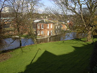
Shepherd Wheel is a working museum in a former water-powered grinding workshop situated on the Porter Brook in the south-west of the City of Sheffield, England. One of the earliest wheels on the River Porter, it is one of the few remaining—and effectively complete—examples of this kind of enterprise, one that used to be commonplace in the Sheffield area. Its 5.5 m (18 ft) diameter overshot water wheel is powered from a large dam stocked with water diverted from the Porter Brook. The workshops, dam, goit and weir are Grade II listed, and the site is a Scheduled Ancient Monument.
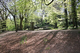
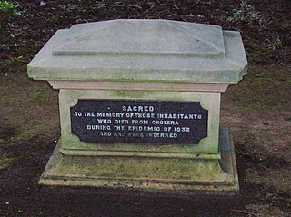
The General Cemetery in the City of Sheffield, England opened in 1836 and closed for burial in 1978. It was the principal cemetery in Victorian Sheffield with over 87,000 burials. Today it is a listed Landscape on the English Heritage National Register of Historic Parks and Gardens. It is also a Local Nature Reserve. It is owned by the City of Sheffield and managed on behalf of the city by a local community group, the Sheffield General Cemetery Trust.

Salthouse is a village and a civil parish in the English county of Norfolk. It is situated on the salt marshes of North Norfolk. It is 3.8 miles (6.1 km) north of Holt, 5.4 miles (8.7 km) west of Sheringham and 26.3 miles (42.3 km) north of Norwich. The village is on the A149 coast road between King's Lynn and Great Yarmouth. The nearest railway station is at Sheringham for the Bittern Line which runs between Sheringham, Cromer and Norwich. The nearest airport is Norwich International Airport. The landscape around Salthouse lies within the Norfolk Coast AONB and the North Norfolk Heritage Coast. The civil parish has an area of 6.22 km2 (2.40 sq mi) and in 2001 had a population of 196 in 88 households, the population increasing to 201 at the 2011 Census. For the purposes of local government, the parish falls within the district of North Norfolk.

Norfolk Heritage Park is a 28-hectare (69-acre) public park in Sheffield, South Yorkshire, England surrounded by the Norfolk Park residential suburb.

Endcliffe Park is a large park in the city of Sheffield, South Yorkshire, England. The park was opened in 1887 to commemorate the Jubilee of Queen Victoria. When travelling West from the city centre it is the first in a series of parks and green spaces, known collectively as the Porter Valley Parks, all of which lie along the course of the Porter Brook. The next park in the sequence is Bingham Park, separated from Endcliffe Park by Rustlings Road. In 1924 Patrick Abercrombie said of the parks, "The Porter Brook Parkway, consisting as it does of a string of contiguous open spaces, is the finest example to be found in this country of a radial park strip, an elongated open space, leading from a built-up part of the city direct into the country, the land occupied being a river valley and so for the greater part unsuitable for building."

Crookes Cemetery is a cemetery between Crosspool and Crookes in the city of Sheffield, South Yorkshire, England. Its main entrance is on Headland Road with additional access from Mulehouse Road. It was opened in 1906, and covers 29 acres (120,000 m2). By 2009, over 29,000 burials had taken place since its opening.

Glossop Road Baths is a building in Sheffield, South Yorkshire, England, which originally housed a swimming pool and Turkish baths.

Mowbray Park is a municipal park in the centre of Sunderland, Tyne and Wear, England, located a few hundred yards from the busy thoroughfares of Holmeside and Fawcett Street and bordered by Sunderland Museum and Winter Gardens to the north, Burdon Road to the west, Toward Road to the east and Park Road to the south. The park was voted best in Britain in 2008.

Woodhouse Moor is an open space approximately one mile (1.6 km) from Leeds city centre, West Yorkshire, England. Today it consists of 3 parts: a formal park, Woodhouse Moor, of around 26 hectares in area on the west of Woodhouse Lane, and two other open areas on the east of it. These are known as the Monument and Cinder Moors which are used for events such as circuses and sporting matches, and sometimes car parking. Woodhouse Moor is north-west of Leeds city centre and is bounded by Woodhouse, the University of Leeds, Burley, Hyde Park, and Headingley.

The Redmires Reservoirs are a group of three reservoirs in Fulwood, Sheffield, South Yorkshire, England. They are fed from the Hallam Moors by various small streams including Fairthorn Clough. The three reservoirs are named Upper, Middle and Lower and were built between 1833 and 1854 to provide clean drinking water via an open water course which led to the Hadfield Dam situated in Crookes, following the devastating Sheffield cholera epidemic of 1832. The dams were built as part of the Sheffield Water Works continuing expansion to meet the ever growing population of Sheffield.
Matthew Ellison Hadfield was an English architect of the Victorian Gothic revival. He is chiefly known for his work on Roman Catholic churches, including the cathedral churches of Salford and Sheffield.

Forge Dam Park is a park in Fulwood, in the city of Sheffield, South Yorkshire, England. Forge Dam Park is the fourth of the Grade II listed Porter Valley Parks, a connected series of parks along the course of the Porter Brook. The 49 acres (20 ha) park is on the site of the Old Mayhouse Farm and Forge Dam. It was acquired by the J G Graves Charitable Trust in 1938.

Brandwood End Cemetery is a cemetery located in the Brandwood ward of Birmingham, England.
Cefn Golau is a disused cholera cemetery situated on a narrow mountain ridge in the county borough of Blaenau Gwent, and located between Rhymney and Tredegar in south-east Wales. A suburb of Tredegar and a nearby feeder reservoir have the same name. The graves date from 1832 to 1855 with many for August and September 1849.
A cholera pit was a burial place used in a time of emergency when the disease was prevalent. Such mass graves were often unmarked and were placed in remote or specially selected locations. Public fears of contagion, lack of space within existing churchyards and restrictions placed on the movements of people from location to location also contributed to their establishment and use. Many of the victims were poor and lacked the funds for memorial stones, however memorials were sometimes added at a later date.
The Marsh Award for Excellence in Public Sculpture is an annual award for public sculpture in the UK or Ireland.

Firth Park is a public park in the Firth Park area of the City of Sheffield in England. It is located 2.33 miles (3.75 km) north-northeast of the city centre. The main entrance to the park is on Hucklow Road although there are several entrances on Firth Park Road to the east and one on Vivian Road to the south. Established in 1875, the park gave its name to the Sheffield suburb of Firth Park, a social housing estate constructed around the area of the park in the 1920s and 1930s.

Women of Steel is a bronze sculpture that commemorates the women of Sheffield who worked in the city's steel industry during the First World War and Second World War. A work of the sculptor Martin Jennings, it was unveiled in June 2016. Women of Steel was given the Keith Hayman Award in the Sheffield Design Awards 2016 and the Public Monuments and Sculpture Association's 2017 Marsh Award for Excellence in Public Sculpture.

The Porter Valley Parks are a series of public parks and green spaces in Sheffield, England. Lying along the valley of Porter Brook, they run radially out from the city centre, providing a direct green-space connection to the Peak District national park. Created variously between 1855 and 1938, they comprise in order from the city centre; Endcliffe Park, Bingham Park, Whiteley Woods, Forge Dam Park and Porter Clough.
