Normanton, West Yorkshire

Last updated

Normanton
Town
Entrance to Normanton High Street from the Market Square - geograph.org.uk - 5361.jpg
Normanton High Street
West Yorkshire UK location map.svg
Red pog.svg
Normanton
Location within West Yorkshire
Population20,872  [1]
OS grid reference SE385225
  London 165 mi (266 km)  south
Civil parish
  • Normanton
Metropolitan borough
Metropolitan county
Region
Country England
Sovereign state United Kingdom
Post town NORMANTON
Postcode district WF6
Dialling code 01924
Police West Yorkshire
Fire West Yorkshire
Ambulance Yorkshire
UK Parliament
Website https://www.normantontowncouncil.co.uk/
List of places
UK
England
Yorkshire
53°41′49″N1°24′58″W / 53.697°N 1.416°W / 53.697; -1.416

Normanton is a town and civil parish in the City of Wakefield in West Yorkshire, England. It is north-east of Wakefield and south-west of Castleford. The civil parish extends west and north to the River Calder, and includes the large village of Altofts. [1] At the time of the 2011 Census, the population of the civil parish was 20,872. [1]

Contents

The Normanton ward of the Wakefield City Council does not include Altofts, but includes the civil parish of Warmfield cum Heath to the south-west of Normanton. The ward had a population of 16,220 in 2011. [2]

Normanton is home to the amateur rugby league Normanton Knights club in the National Conference League.

History

The Domesday Book gives information on 'Norman-tune' [3] as:

In Normantune there are 10 carucates for geld, which 5 plows can plough. 2 thegns had 2 manors there T.R.E. Now, in the King's hand there are 6 villeins there, and 3 bordars, a priest and a church, with 3 ploughs, 3 acres (12,000 m2) of meadow. Pasturable wood (land) 6 furlongs in length and 1 in breadth. The whole of this land lies in the soc of Wachefelt, except the Church. T.R.E. it was worth 12s: now (it is worth) 10s. [4]

Normanton was originally surrounded by a moat, and in Norman times was the site of an enclosed settlement (chosen for its strategic view points across the surrounding area), and became known as 'Norman – tune', or 'Norman – ton'.

At the time the Domesday Book was compiled in 1086, the occupation of Yorkshire by the Normans was underway. Archaeological evidence at today's Normanton points to Haw Hill (or How Hill), an eminence that was probably a Norman defensive strategic mound once reinforced by a wooden palisade. [5] The evidence of a Norman motte-and-bailey fortification at the town, and the name, is likely evidence that Normanton's name derived from the Anglo-Norman presence in the area. Nearby, after all, were Tickhill, the fortress of Norman magnate Roger de Busli, as well as other new Norman power centres. Although the area had once been part of the Scandinavian Danelaw, William the Conqueror's scorched earth northern campaign had left the area ripe for exploitation by his Lords. By all measures, Normanton likely owes its name to these new invaders.

Hanson House, Normanton, c. 1890 Hanson House circa 1890 Normanton West Yorkshire.jpg
Hanson House, Normanton, c.1890

One of the earliest buildings to survive within the village is Hanson House. [6] This is set back from the church and has a timber-frame construction. The building was constructed in the mid-15th century, with a later wing added in the 18th century. A fire has damaged the building, which is being restored and modernised.

Growth

All Saints' Parish Church rooms c. 1880 Normanton old.jpg
All Saints' Parish Church rooms c.1880
All Saints' Parish Church rooms in 2008 Normanton community centre today.jpg
All Saints' Parish Church rooms in 2008

A grammar school was founded in Normanton by John Freeston (now the 'Parish Rooms'..later moved to the site of the, Normanton Junior School on Church Lane) in 1592, [7] but the town remained very small until it became the focus of several railway lines in the mid-19th century. Work began in 1837 under the supervision of George Stephenson on the construction of the North Midland Railway from Derby to Leeds. This was soon followed by an addition to the York and North Midland Railway from York and then the Manchester and Leeds Railway from Manchester which all extended to Normanton thereby giving the town access to much of the country. The Leeds and Manchester lines crossed a 51-mile (82 km) stretch across the Pennines and at the time had the world's longest railway station platform at Normanton, a quarter of a mile long. The station was, for the next ten years or so, the most important in England, employing over 700 people who looked after the station's 700,000 passengers a year.

In Victorian times Normanton station was one of the most important stations in Northern England, and Queen Victoria stopped over in the Station Hotel. The town also served as an important part of the transport infrastructure for national and local industries including coal and bricks, although most of this was lost during the 1950s and 1960s with the last remaining operational brickworks eventually closing in the mid-1990s. There were three brickworks in town which were all built within the small area of Newland, taking advantage of the abundance of clay from the area. A fourth works was founded in the 1890s by a Thomas Kirk from Nottingham, who had heard rumours that Normanton was rapidly turning into an important junction on the railways. Both Kirk and his sons used their life savings and formed the Normanton Brick Company at nearby Altofts which finally closed in 2011

The coming of the railways enabled the locally mined coal to be sent across the country. Demand soon outstripped supply and many more shafts were sunk to reach the coal seams under the town. In 1871 Dom Pedro, the Emperor of Brazil, visited Normanton with his Empress and gave his name (in a slightly altered form) to the Don Pedro Colliery at Hopetown. Today roads in the area of the former colliery retain the name. At their peak the collieries employed over 10,000 men, most of whom wanted to move themselves and their families to Normanton. The town enjoyed a boom period with more mines opening and more shafts being sunk in order to meet the increasing demand for coal until, by the mid-1970s, most coal seams in the Normanton area were worked-out.

Decline

The disputes surrounding the miners' strike of 1984–85 meant that many mines across the country were to close although by this stage there were no collieries still in production in Normanton. However, the strike still affected many families in the area, as Normanton colliers still worked in pits in neighbouring towns. The area once occupied by the St John's or Newland Colliery is now part of the controversial Welbeck landfill site which has been the subject of both local and national media attention since its development as a toxic tip. The site attracted so much negative attention that the group Residents Against Toxic Scheme (RATS) was established to halt planning permission for the disposal of toxic chemicals at the site, claiming the scheme was an extreme health hazard.

Normanton suffered decline in the years following the miners' strike. The railway station was in such a state of neglect and disrepair that the decision was made to demolish it in 1986; the section of railway line between Goosehill Junction and Crofton Interchange were lifted the year after. Very little now remains of Normanton's railway and mining heritage.

Modern

Normanton has become a growing commuter suburb of the Leeds City Region, with relatively cheap housing and efficient transport links. The town is still accessible via Normanton railway station, and is currently served by an unmanned island platform station with regular trains to Leeds, Castleford, Wakefield and Sheffield Meadowhall Interchange.

The addition and expansion of the Eurolink Industrial Estate at Junction 31 of the M62 attracted national and multi-national corporations to locate their distribution depots to Normanton. Being centrally located within the UK, the town is served by three major motorway networks: the M62 linking Liverpool to Hull (west to east); the M1 linking Leeds to London (North to South); and the North of England via a new link between the M62 and the A1(M) at nearby Ferrybridge.

Landmarks

Church

All Saints' Church, Normanton All Saints Church Normanton.jpg
All Saints' Church, Normanton

All Saints' is the Church of England parish church of Normanton, West Yorkshire. It is believed to have existed since at least 1256 and is built in the Perpendicular style.

Newland

The Newland estate was a small township on the outskirts of Normanton and lies on the north bank of the River Calder. Existing since 1213 when it was established by King John as a preceptory of the Knights Templar, it was later transferred to the similar organisation, the "Knights Hospitaller" in 1256. [7] The property belonging to the Hospitallers was dissolved by King Henry VIII who bestowed the property upon himself. The earliest known preceptor of the Knights Hospitaller was Simon Paccable in 1313. Newland was once held by the Levett family, and William Levett, who was lord of the manor, was admitted tenant of the Knights Hospitaller on 2 October 1447. [8]

The estate changed hands of ownership a number of times since King Henry VIII sold the land in 1544, with final ownership landing on the Warmfield Company Limited in 1926, who ran brickworks until the mid-20th century.[ citation needed ]

Newland today is kept as a nature reserve, with the remains of the estate overgrown with shrubs and plant life, the remains of Newland Hall still stand in the woodlands as a derelict building that last saw occupancy in 1972. [9] A small fishing area just outside the Newland Estate is used by local fishermen.

Transport

Normanton railway station. Normanton station 144004.jpg
Normanton railway station.

Normanton is just off of Junction 31 of the M62. It has a railway station, Normanton Railway Station. The town is on bus routes [10] and is served by taxi and minibus companies.

Education

The following is a list of schools in the Normanton area:

Media

Local news and television programmes are provided by BBC Yorkshire and ITV Yorkshire. Television signals are received from the Emley Moor TV transmitter. [11]

Local radio stations are BBC Radio Leeds, Heart Yorkshire, Capital Yorkshire, Pulse 1, Greatest Hits Radio Yorkshire (formerly Ridings FM), Rhubarb Radio and 5 Towns FM, a community station that broadcasts from Castleford. [12]

The town is served the local newspaper, Wakefield Express . [13]

Sports

The town is home to a cricket club – Normanton St John's CC, and 2 football teams – A.S. Normanton F.C. and Normanton Athletic Juniors. Arguably the biggest sport in the area is Rugby League. Normanton Knights are the town's main amateur club and play in the National Conference League.

Notable people

Filmography

The old Normanton brickyard, situated just off of the A655 Wakefield Road, was used in the late-1990s as the fictional setting of a murder in the ITV series A Touch Of Frost . The structure was intact but abandoned at the time of filming and was the ideal location favoured by the ITV production team.[ according to whom? ] In the series a body was found by the Police in one of the factory's old kilns. Within 18 months of filming, the structure had been declared unsafe, and was partially demolished, leaving only the chimney stack standing.[ citation needed ]

See also

Related Research Articles

<span class="mw-page-title-main">West Yorkshire</span> County of England

West Yorkshire is a ceremonial county in the Yorkshire and the Humber region of England. It borders North Yorkshire to the north and east, South Yorkshire and Derbyshire to the south, Greater Manchester to the south-west, and Lancashire to the west. The city of Leeds is the largest settlement.

<span class="mw-page-title-main">Castleford</span> Town in West Yorkshire, England

Castleford is a town within the City of Wakefield district, West Yorkshire, England. It had a population of 45,106 at a 2021 population estimate. Historically in the West Riding of Yorkshire, to the north of the town centre the River Calder joins the River Aire and the Aire and Calder Navigation. It is located north east of Wakefield, north of Pontefract and south east of Leeds. Castleford is the largest town in the Wakefield district after Wakefield itself.

<span class="mw-page-title-main">Ossett</span> Town in West Yorkshire, England

Ossett is a market town in West Yorkshire, England, within the City of Wakefield. Historically part of the West Riding of Yorkshire, it is situated between Dewsbury, Horbury and Wakefield. At the 2021 census, the town had a population of 21,861. Ossett forms part of the Heavy Woollen District.

<span class="mw-page-title-main">Pontefract</span> Market town in West Yorkshire, England

Pontefract is a historic market town in the Metropolitan Borough of Wakefield in West Yorkshire, England, east of Wakefield and south of Castleford. Historically part of the West Riding of Yorkshire, it is one of the towns in the City of Wakefield district and had a population of 30,881 at the 2011 Census. Pontefract's motto is Post mortem patris pro filio, Latin for "After the death of the father, support the son", a reference to the town's Royalist sympathies in the English Civil War. Small villages and settlements in the immediate area include Stapleton.

<span class="mw-page-title-main">Morley, West Yorkshire</span> Market town and civil parish in West Yorkshire, England

Morley is a market town and a civil parish within the City of Leeds metropolitan borough, in West Yorkshire, England. Morley is the largest town in the borough after Leeds itself. Morley forms part of the Heavy Woollen District.

<span class="mw-page-title-main">Knottingley</span> Town in the City of Wakefield, West Yorkshire, England

Knottingley is a town in the City of Wakefield in West Yorkshire, England on the River Aire and the old A1 road before it was bypassed as the A1(M). Historically part of the West Riding of Yorkshire, it has a population of 13,503, increasing to 13,710 for the City of Wakefield ward at the 2011 Census. It makes up the majority of the Knottingley ward represented on Wakefield Council.

<span class="mw-page-title-main">Featherstone</span> Town and civil parish in West Yorkshire, England

Featherstone is a town and civil parish in the City of Wakefield, West Yorkshire, England, two miles south-west of Pontefract. Historically part of the West Riding of Yorkshire, in 2011 it had a population of 15,244. Featherstone railway station is on the Pontefract Line.

<span class="mw-page-title-main">South Elmsall</span> Town and civil parish in West Yorkshire, England

South Elmsall is a town and civil parish in the City of Wakefield in West Yorkshire, England. South Elmsall lies to the east of Hemsworth. The town had a population in 2001 of 6,107, increasing to 6,519 at the 2011 Census.

<span class="mw-page-title-main">Hallam Line</span> Railway line in Yorkshire, England

The Hallam Line is a railway connecting Leeds and Sheffield via Castleford in the West Yorkshire Metro area of northern England. It is a slower route from Leeds to Sheffield than the Wakefield line. Services on this line are operated by Northern Trains. Services from Leeds to Nottingham also use the line.

Streethouse is a semi rural village in West Yorkshire, England that is situated to the east of Wakefield, the west of Featherstone and the south-west of Castleford. It is also situated on a Roman road.

<span class="mw-page-title-main">Garforth</span> Town in West Yorkshire, England

Garforth is a town in the metropolitan borough of the City of Leeds, West Yorkshire, England.

<span class="mw-page-title-main">Methley</span> Village in West Yorkshire, England

Methley is a dispersed village in the City of Leeds metropolitan borough, south east of Leeds, West Yorkshire, England. It is located near Rothwell, Oulton, Woodlesford, Mickletown and Allerton Bywater. The Leeds City Ward is called Kippax and Methley. It is within the triangle formed by Leeds, Castleford and Wakefield, and between the confluence of the River Aire and River Calder. The latter is crossed by Methley Bridge, the A639 road, about a mile south-east of the village.

<span class="mw-page-title-main">Normanton (UK Parliament constituency)</span> Parliamentary constituency in the United Kingdom, 1885-2010

<span class="mw-page-title-main">Normanton railway station</span> Railway station in West Yorkshire, England

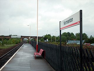
Normanton railway station serves the town of Normanton in West Yorkshire, England. It lies 11 miles (18 km) south-east of Leeds railway station on the Hallam Line, which is operated by Northern.

<span class="mw-page-title-main">Newland with Woodhouse Moor</span> Civil parish in West Yorkshire, England

Newland with Woodhouse Moor is a civil parish in the City of Wakefield in West Yorkshire, England, consisting of some open countryside west of Normanton, including Newland Hall.

<span class="mw-page-title-main">Altofts</span> Village in Wakefield, West Yorkshire, England

Altofts is a village in West Yorkshire, England. It lies 5 miles (8 km) north-east from the centre of Wakefield and less than 1 mile (1.6 km) north-west of Normanton. The M62 runs close to the village to the north-east, and the Aire and Calder Navigation to the north-west.

<span class="mw-page-title-main">Normanton, Pontefract and Castleford (UK Parliament constituency)</span> Parliamentary constituency in the United Kingdom

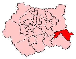
Normanton, Pontefract and Castleford is a constituency in West Yorkshire represented in the House of Commons of the UK Parliament by Yvette Cooper of the Labour Party since its 2010 creation. Cooper has served under the governments of Tony Blair and Gordon Brown alongside her husband Ed Balls, and served as Shadow Home Secretary under the leadership of Ed Miliband. Having served as chair of the Home Affairs Select Committee, she is once again the Shadow Home Secretary.

<span class="mw-page-title-main">Woodlesford</span> Village in West Yorkshire, England

Woodlesford is a suburban village in the City of Leeds, West Yorkshire, England, 6 miles (10 km) south-east of Leeds city centre. Formerly part of the Rothwell Urban District, it is now within the Rothwell ward of Leeds City Council. The village sits on the banks of the Aire and Calder Navigation and river system.

<span class="mw-page-title-main">All Saints' Church, Normanton</span> Anglican Church in Normanton, West Yorkshire, England

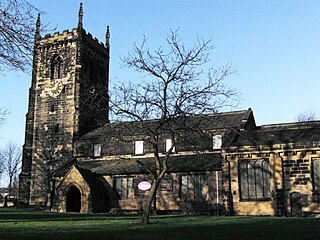
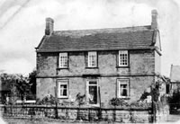
All Saints' Church is the parish church in Normanton, West Yorkshire, England.

Wakefield Europort is a rail-connected warehousing and industrial estate located to the northeast of Wakefield at junction 31 of the M62 motorway in West Yorkshire, England. It opened in 1996 in anticipation of increased international railfreight due to the construction of the Channel Tunnel. As of 2012 the site employs over 3,000 persons, and has motorway, high capacity rail, and waterway (canal) transport access.

References

  1. 1 2 3 UK Census (2011). "Local Area Report – Normanton Parish (E04000236)". Nomis. Office for National Statistics . Retrieved 17 January 2022.
  2. UK Census (2011). "Local Area Report – Normanton Ward (as of 2011) (E05001453)". Nomis. Office for National Statistics . Retrieved 17 January 2022.
  3. "Normanton – Domesday Book". domesdaymap.co.uk. Retrieved 19 November 2017.
  4. A History of Normanton & District, R.H. Pestell, 1973
  5. Normanton, Its Name, History of Normanton, wakefield.gov.uk Archived 9 January 2009 at the Wayback Machine
  6. Hampson, Walter. "History of Normanton". wakefield.gov.uk. Archived from the original on 2 September 2012.
  7. 1 2 Pastell, Ibid.[ full citation needed ]
  8. Banks, William Stott (19 November 1871). Walks in Yorkshire; Wakefield and Its Neighbourhood: With Map, and Fifty-five Woodcuts. Longmans, Green, Reader and Dyer. p.  231 . Retrieved 19 November 2017 via Internet Archive. walks in yorkshire lyvett levett.
  9. "Stanley History Online – Newland Estate". Stanley History Online. Retrieved 19 November 2017.
  10. "Normanton, Wakefield – Bus Times". bustimes.org. Retrieved 22 January 2019.
  11. "Emley Moor (Kirklees, England) Full Freeview transmitter". UK Free TV. 1 May 2004. Retrieved 4 December 2023.
  12. "5 Towns FM Radio Online". Internetradiouk.com. Retrieved 4 December 2002.
  13. "Wakefield Express". British Papers. 17 July 2013. Retrieved 4 December 2023.
  14. Earnshaw, Tony (14 February 2018). "Tributes to Sir Lawrence Byford the man who changed the face of modern policing". Examiner Live. Retrieved 25 November 2019.
  15. "03. Normanton – its old houses and ancient families (part1)" by Walter Hampson, 1928
  16. "Hanson, Levett"  . Dictionary of National Biography . London: Smith, Elder & Co. 1885–1900.
  17. Ferguson, Shawn Dollin and Andrew. "Jamie Langley – Career Stats & Summary – Rugby League Project". Rugbyleagueproject.org. Retrieved 19 November 2017.
  18. Lishman, Tamsin (8 February 2021). "Joyce Lishman obituary". The Guardian. Retrieved 26 May 2021.
  19. "David Topliss: Tributes to a legend". Wakefield Express. 23 June 2008. Retrieved 17 November 2017.