
Park County is a county in the U.S. state of Montana. At the 2020 census, the population was 17,191. Its county seat is Livingston. A small part of Yellowstone National Park is in the southern part of the county.

Madison County is a county in the U.S. state of Montana. As of the 2020 census, the population was 8,623. Its county seat is Virginia City. The county was founded in 1865; at the time it was part of the Montana Territory.

Gallatin County is located in the U.S. state of Montana. With its county seat in Bozeman, it is the second-most populous county in Montana, with a population of 118,960 in the 2020 Census.

Four Corners is a census-designated place (CDP) in Gallatin County, Montana, United States. The population was 5,901 at the 2020 census, up from 3,146 in 2010. It is part of the Bozeman, MT Micropolitan Statistical Area.

Augusta is an unincorporated community and census-designated place (CDP) in Lewis and Clark County, Montana, United States. The population was 309 at the 2010 census and rose to 316 in the 2020 census. The most accepted version in the naming of this town is after Augusta Hogan, thought to be the first child born in this town, the daughter of J. D. Hogan, an early rancher.

Alder is an unincorporated community and census-designated place (CDP) in Madison County, Montana, United States. The population was 86 at the 2020 census, down from 103 in 2010. The community takes its name from Alder Creek, the site of the second major gold discovery in Montana.

Harrison is an unincorporated community and census-designated place (CDP) in Madison County, Montana, United States. The population was 105 at the 2020 census, down from 137 in 2010.

Cardwell is a census-designated place (CDP) in Jefferson County, Montana, United States. The population was 62 at the 2020 census. It is part of the Helena Micropolitan Statistical Area.
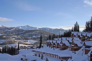
Big Sky is an unincorporated community and census-designated place (CDP) in Gallatin and Madison counties in southwestern Montana, United States. As of the 2020 census, it had a population of 3,591, up from 2,308 in 2010. It is 44 miles (71 km) by road southwest of Bozeman. The primary industry of the area is tourism.

U.S. Route 191 is a north–south highway in the Western United States and a spur of parent route U.S. Route 91 that has two segments. The southern segment runs for 1,102 miles (1,773 km) from Douglas, Arizona on the Mexican border to the southern part of Yellowstone National Park. The northern segment runs for 442 miles (711 km) from the northern part of Yellowstone National Park to Loring, Montana, at the Canada–US border. Unnumbered roads within Yellowstone National Park connect the two segments. The highway passes through the states of Arizona, Utah, Wyoming, and Montana.

Pony is an unincorporated community and census-designated place in northeastern Madison County, Montana, United States, on the eastern edge of the Tobacco Root Mountains. As of the 2020 census, it had a population of 127. It includes the 192-acre (78 ha) Pony Historic District, a historic district with 95 contributing buildings listed on the National Register of Historic Places.
Highway 85 is a 6.704-mile-long (10.789 km) north–south state highway traversing the central Gallatin Valley in the U.S. State of Montana. The highway's southern terminus, just north of Bozeman Hot Springs and about 7 miles (11 km) west of Bozeman, is a census-designated place (CDP) known as "Four Corners." From Four Corners, U.S. Route 191 (US 191) runs east to Bozeman, and south to West Yellowstone; MT 84 travels west to Norris; and MT 85 runs north to Belgrade. The designated MT 85 terminates near the southern end of Belgrade, at an interchange with Interstate 90 (I-90).
Highway 84 is a 28.904-mile-long (46.516 km) east–west state highway in the U.S. State of Montana. MT 84's western terminus is at U.S. Route 287 in the small community of Norris and the eastern terminus is at US 191 and MT 85 at Four Corners. The highway's eastern terminus, about 7 miles (11 km) west of Bozeman, is a location known locally as "Four Corners." From Four Corners, US 191 runs east to Bozeman, and south to West Yellowstone; Highway 84 travels west to Norris; and Montana Highway 85 runs north to Belgrade.

Interstate 90 (I-90) is an east–west transcontinental Interstate Highway across the northern United States, linking Seattle to Boston. The portion in the state of Montana is 552.54 miles (889.23 km) in length, passing through 14 counties in central and southern Montana. It is the longest segment of I-90 within a single state.
Swan Lake is a census-designated place and unincorporated community in Lake County, Montana, United States. Its population was 113 as of the 2010 census.
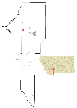
Churchill is a census-designated place (CDP) in Gallatin County, Montana, United States. The population was 1,030 at the 2020 census. It is part of the Bozeman, MT Micropolitan Statistical Area. It was formerly part of the Amsterdam-Churchill CDP.
McAllister is an unincorporated community and census-designated place in Madison County, Montana, United States. As of the 2020 census, it had a population of 278. McAllister is located on U.S. Route 287, 6 miles (10 km) north of Ennis. The community has a post office with ZIP code 59740.
Silver Star is an unincorporated community and census-designated place in Madison County, Montana, United States. As of the 2020 census, it had a population of 46. It is located on Montana Highway 41, 10 miles (16 km) north-northeast of Twin Bridges and 16 miles (26 km) southwest of Whitehall. The community has a post office with ZIP code 59751.
Bridger is a census-designated place (CDP) in Gallatin County, Montana, United States. It comprises the Bridger Bowl Ski Area and some nearby residences on the eastern side of the Bridger Range in southwestern Montana. As of the 2010 census the Bridger CDP had a population of 30.

Gilman is an unincorporated community and census-designated place (CDP) in Lewis and Clark County, Montana, United States. It is near the northern border of the county, on the east side of U.S. Route 287. Augusta is less than 2 miles (3 km) to the southwest. US-287 leads northeast from Gilman 24 miles (39 km) to Choteau and south through Augusta 40 miles (64 km) to Interstate 15 near Wolf Creek. Montana Highway 21 forms the southern edge of Gilman and leads east 21 miles (34 km) to Simms.


