Sheridan, Montana

Last updated

Sheridan, Montana
Madison County Montana Incorporated and Unincorporated areas Sheridan Highlighted.svg
Location of Sheridan, Montana
Coordinates: 45°27′22″N112°11′45″W / 45.45611°N 112.19583°W / 45.45611; -112.19583
Country United States
State Montana
County Madison
Area
[1]
  Total1.01 sq mi (2.62 km2)
  Land1.01 sq mi (2.62 km2)
  Water0.00 sq mi (0.00 km2)
Elevation
5,115 ft (1,559 m)
Population
 (2020)
  Total694
  Density686.45/sq mi (264.92/km2)
Time zone UTC-7 (Mountain (MST))
  Summer (DST) UTC-6 (MDT)
ZIP code
59749
Area code 406
FIPS code 30-67600
GNIS feature ID0776478

Sheridan is a town in Madison County, Montana, United States named after the Civil War general Philip Sheridan. The population was 694 at the 2020 census. [2] Sheridan is known as the "heart of the Ruby Valley." Seven mountain ranges surround the town: Tobacco Root Mountains, Highland Mountains, McCartney Mountain, The Pioneers, The Ruby Range, The Gravelly Range and the Snowcrest Range. The Ruby River winds through the valley just west of the town.

Contents

Sheridan traces its beginnings to the construction of a sawmill on Mill Creek by James Gammell in 1863. [3]

Geography

Sheridan is located at 45°27′22″N112°11′45″W / 45.45611°N 112.19583°W / 45.45611; -112.19583 (45.456173, -112.195793). [4] Montana Highway 287 passes through town.

According to the United States Census Bureau, the town has a total area of 1.02 square miles (2.64 km2), all land. [5]

Climate

According to the Köppen Climate Classification system, Sheridan has a semi-arid climate, abbreviated "BSk" on climate maps. [6]

Demographics

Historical population
CensusPop.Note
1880 156
1890 20732.7%
1900 581180.7%
1910 399−31.3%
1920 53834.8%
1930 521−3.2%
1940 59714.6%
1950 572−4.2%
1960 539−5.8%
1970 63618.0%
1980 6461.6%
1990 6520.9%
2000 6591.1%
2010 642−2.6%
2020 6948.1%
U.S. Decennial Census [7] [2]

2010 census

As of the census [8] of 2010, there were 642 people, 306 households, and 174 families residing in the town. The population density was 629.4 inhabitants per square mile (243.0/km2). There were 376 housing units at an average density of 368.6 per square mile (142.3/km2). The racial makeup of the town was 95.3% White, 0.3% African American, 0.5% Native American, 0.5% Asian, 0.5% from other races, and 3.0% from two or more races. Hispanic or Latino of any race were 1.1% of the population.

There were 306 households, of which 23.2% had children under the age of 18 living with them, 45.1% were married couples living together, 8.8% had a female householder with no husband present, 2.9% had a male householder with no wife present, and 43.1% were non-families. 40.2% of all households were made up of individuals, and 20.9% had someone living alone who was 65 years of age or older. The average household size was 1.99 and the average family size was 2.66.

The median age in the town was 53.1 years. 19.2% of residents were under the age of 18; 2.6% were between the ages of 18 and 24; 17.3% were from 25 to 44; 32% were from 45 to 64; and 29% were 65 years of age or older. The gender makeup of the town was 45.3% male and 54.7% female.

2000 census

As of the census [9] of 2000, there were 659 people, 302 households, and 170 families residing in the town. The population density was 643.4 inhabitants per square mile (248.4/km2). There were 365 housing units at an average density of 356.3 per square mile (137.6/km2). The racial makeup of the town was 95.14% White, 0.15% African American, 1.06% Native American, 1.67% from other races, and 1.97% from two or more races. Hispanic or Latino of any race were 1.67% of the population.

There were 302 households, out of which 22.8% had children under the age of 18 living with them, 49.0% were married couples living together, 5.3% had a female householder with no husband present, and 43.7% were non-families. 39.4% of all households were made up of individuals, and 24.8% had someone living alone who was 65 years of age or older. The average household size was 2.07 and the average family size was 2.78.

In the town, the population was spread out, with 20.5% under the age of 18, 3.8% from 18 to 24, 20.5% from 25 to 44, 26.4% from 45 to 64, and 28.8% who were 65 years of age or older. The median age was 48 years. For every 100 females there were 85.6 males. For every 100 females age 18 and over, there were 77.0 males.

The median income for a household in the town was $21,118, and the median income for a family was $26,563. Males had a median income of $27,639 versus $15,000 for females. The per capita income for the town was $15,369. About 22.0% of families and 25.1% of the population were below the poverty line, including 43.2% of those under age 18 and 13.1% of those age 65 or over.

Education

Sheridan Public Schools educates students from kindergarten through 12th grade. [10] Sheridan High School's team name is the Panthers. [11]

Sheridan Public Library serves the area. [12]

Media

The Madisonian is a newspaper serving the Madison and Ruby Valleys, which includes Sheridan. [13] It is printed weekly and offers an e-edition.

Related Research Articles

<span class="mw-page-title-main">Sheridan County, Wyoming</span> County in Wyoming, United States

Sheridan County is a county in the U.S. state of Wyoming. As of the 2020 United States Census, the population was 30,921. The county seat is Sheridan. Its northern boundary abuts the Montana state border.

<span class="mw-page-title-main">Sheridan County, Montana</span> County in Montana, United States

Sheridan County is a county in the U.S. state of Montana. As of the 2020 census, the population was 3,539. Its county seat is Plentywood. Its northern boundary is the Canada–United States border south of Saskatchewan.

<span class="mw-page-title-main">Madison County, Montana</span> County in Montana, United States

Madison County is a county in the U.S. state of Montana. As of the 2020 census, the population was 8,623. Its county seat is Virginia City. The county was founded in 1865; at the time it was part of the Montana Territory.

<span class="mw-page-title-main">South Taft, California</span> Census-designated place in California, United States

South Taft is a census-designated place (CDP) in Kern County, California, United States. South Taft is located 0.5 miles (0.8 km) south of Taft, at an elevation of 1,017 feet (310 m). The population was 2,169 at the 2010 census, up from 1,898 at the time of the 2000 census.

<span class="mw-page-title-main">Sibley, Missouri</span> Village in Missouri, United States

Sibley is a village in Jackson County, Missouri, United States. The population was 314 at the 2020 census. It is known as the home of Fort Osage National Historic Landmark. It is part of the Kansas City metropolitan area.

<span class="mw-page-title-main">Sheridan, Missouri</span> City in Missouri, United States

Sheridan is a city in northwest Worth County, Missouri, United States, near the Platte River. The population was 195 at the 2010 census.

<span class="mw-page-title-main">Fromberg, Montana</span> Town in Carbon County, Montana, United States

Fromberg is a town in Carbon County, Montana, United States. As of the 2020 census, the population of the town was 392.

<span class="mw-page-title-main">Alder, Montana</span> Census-designated place in Montana, United States

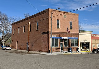
Alder is a census-designated place (CDP) in Madison County, Montana, United States. The population was 86 at the 2020 census. The community takes its name from Alder Creek, the site of the second major gold discovery in Montana.

<span class="mw-page-title-main">Ennis, Montana</span> Town in Montana, United States

Ennis is a town in Madison County, Montana, United States, in the southwestern part of the state. The population was 917 at the 2020 census.

<span class="mw-page-title-main">Twin Bridges, Montana</span> Town in Montana, United States

Twin Bridges is a town in Madison County, Montana, United States. It lies at the confluence of the Ruby, Beaverhead and Big Hole Rivers which form the Jefferson River. Twin Bridges is a well-known fly fishing mecca for trout anglers. The population was 330 at the 2020 census.

<span class="mw-page-title-main">Heart Butte, Montana</span> Census–designated place in Pondera County, Montana

Heart Butte is a census-designated place (CDP) in Pondera County, Montana, United States. The population was 698 at the 2000 census. The town is on the Blackfeet Indian Reservation.

<span class="mw-page-title-main">Avon, Montana</span> CDP in Montana, United States

Avon is a census-designated place (CDP) in Powell County, Montana, United States. The population was 124 at the 2000 census. The town sits along the Little Blackfoot River, and serves as a gateway to the Beaverhead-Deerlodge National Forest.

<span class="mw-page-title-main">Medicine Lake, Montana</span> Town in Montana, United States

Medicine Lake is a town in Sheridan County, Montana, United States. The population was 244 at the 2020 census.

<span class="mw-page-title-main">Outlook, Montana</span> Town in Montana, United States

Outlook is a small rural village in Sheridan County, Montana, United States. The population was 84 at the 2020 census. The village includes a post office which services Outlook and the hamlet of Raymond, as well as the surrounding countryside.

<span class="mw-page-title-main">Plentywood, Montana</span> City in Montana, United States

Plentywood is a city in and the county seat of Sheridan County, Montana, United States. The population was 1,669 at the 2020 census.

<span class="mw-page-title-main">Reserve, Montana</span> CDP in Montana, United States

Reserve is a census-designated place (CDP) in Sheridan County, Montana, United States. The population was 23 at the 2010 census.

<span class="mw-page-title-main">Westby, Montana</span> Town in Montana, United States

Westby is a town in Sheridan County, Montana, United States. The population was 167 at the 2020 census.

<span class="mw-page-title-main">Broadview, Montana</span> Town in Montana, United States

Broadview is a town in Yellowstone County, Montana, United States. The population was 139 at the 2020 census.

<span class="mw-page-title-main">Wolfdale, Pennsylvania</span> Census-designated place in Pennsylvania, United States

Wolfdale is a census-designated place (CDP) in Washington County, Pennsylvania, United States. The population was 2,888 at the 2010 census.

<span class="mw-page-title-main">Clearmont, Wyoming</span> Town in Wyoming, United States

Clearmont is a town in Sheridan County, Wyoming, United States. The population was 142 at the 2010 census.

References

  1. "ArcGIS REST Services Directory". United States Census Bureau. Retrieved September 5, 2022.
  2. 1 2 "U.S. Census website". United States Census Bureau . Retrieved November 2, 2021.
  3. "Sheridan". Montana Place Names Companion. Montana Historical Society. Retrieved April 9, 2021.
  4. "US Gazetteer files: 2010, 2000, and 1990". United States Census Bureau. February 12, 2011. Retrieved April 23, 2011.
  5. "US Gazetteer files 2010". United States Census Bureau. Archived from the original on January 25, 2012. Retrieved December 18, 2012.
  6. Climate Summary for Sheridan, Montana
  7. "Census of Population and Housing". Census.gov. Retrieved July 23, 2016.
  8. "U.S. Census website". United States Census Bureau . Retrieved December 18, 2012.
  9. "U.S. Census website". United States Census Bureau . Retrieved January 31, 2008.
  10. "Sheridan Public Schools". Sheridan Public Schools. Retrieved April 13, 2021.
  11. "Member Schools". Montana High School Association. Retrieved April 19, 2021.
  12. "Sheridan Public Library". Sheridan Public Library. Retrieved April 13, 2021.
  13. "Home page". The Madisonian. Retrieved August 27, 2023.