North Carolina Highway 130

Last updated

NC 130.svg

North Carolina Highway 130
NC 130 map.svg
Route information
Maintained by NCDOT
Length 101.5 mi [1] (163.3 km)
Existed 1928 – present
Major junctions
West endBusiness plate.svgNo image wide.svg
US 74.svgNC 71.svg US 74 Bus. / NC 71 in Maxton
 
East end Ocean Boulevard in Holden Beach
Location
Counties Robeson, Columbus, Brunswick
Highway system
US 129.svg US 129 NC 131 NC 131.svg

North Carolina Highway 130 (NC 130) is a primary state highway in the U.S. state of North Carolina. The highway serves the towns and rural communities in southern Robeson County, acts as a direct route between Whiteville and Shallotte through the Green Swamp, and provides access to Holden Beach.

A state highway, state road, or state route is usually a road that is either numbered or maintained by a sub-national state or province. A road numbered by a state or province falls below numbered national highways in the hierarchy. Roads maintained by a state or province include both nationally numbered highways and un-numbered state highways. Depending on the state, "state highway" may be used for one meaning and "state road" or "state route" for the other.

North Carolina State of the United States of America

North Carolina is a state in the southeastern region of the United States. It borders South Carolina and Georgia to the south, Tennessee to the west, Virginia to the north, and the Atlantic Ocean to the east. North Carolina is the 28th-most extensive and the 9th-most populous of the U.S. states. The state is divided into 100 counties. The capital is Raleigh, which along with Durham and Chapel Hill is home to the largest research park in the United States. The most populous municipality is Charlotte, which is the second-largest banking center in the United States after New York City.

Robeson County, North Carolina County in the United States

Robeson County is a county in the southern part of the U.S. state of North Carolina. As of the 2010 census, the population was 134,168. Its county seat is Lumberton. The county was formed in 1787 from part of Bladen County. It was named in honor of Col. Thomas Robeson of Tar Heel, a hero of the Revolutionary War.

Contents

Route description

NC Highway 130 begins at U.S. Route 74 Business (US 74 Bus.) and NC 71 in Maxton and ends at Ocean Boulevard in Holden Beach.

North Carolina Highway 71 highway in North Carolina

North Carolina Highway 71 is a state highway that serves the communities of Maxton, Red Springs, Shannon, Lumber Bridge, and Parkton. Most of the highway travels through Robeson County but a short portion of it passes through Scotland County.

Maxton, North Carolina Town in North Carolina, United States

Maxton is a town in Robeson and Scotland counties, North Carolina, United States. The population was 2,426 at the time of the 2010 U.S. Census.

It overlaps several highways along its route, including US 501, US 74 (proposed Interstate 74), US 76, NC 410 and US 17 Bus.

Concurrency (road) instance of one physical road bearing two or more different highways

A concurrency in a road network is an instance of one physical roadway bearing two or more different route numbers. When two roadways share the same right-of-way, it is sometimes called a common section or commons. Other terminology for a concurrency includes overlap, coincidence, duplex, triplex, multiplex, dual routing or triple routing.

U.S. Route 501 is a spur of U.S. Route 1. It runs 355 miles (571 km) from Buena Vista, Virginia at U.S. Route 60 to Myrtle Beach, South Carolina at U.S. Route 17 Business. It passes through the states of Virginia, North Carolina and South Carolina. From Durham to Laurinburg, a 108-mile (174 km) section of US 501 overlaps U.S. Route 15. Sections of US 15-501 also share routings with U.S. Route 1 in sections near Sanford, North Carolina and Aberdeen, North Carolina.

U.S. Route 74 (US 74) is an east–west United States highway that runs for 515 miles (829 km) from Chattanooga, Tennessee to Wrightsville Beach, North Carolina. Predominantly in North Carolina, it serves as an important highway from the mountains to the sea, connecting the cities of Asheville, Charlotte and Wilmington.

History

NC 130 was established around 1928 as a renumbering of part of NC 201 between NC 30 in Supply, to the intersection of Moore Street and Atlantic Avenue in Southport. In 1930, NC 130 was extended west along NC 30 to Shallotte, then northwest along new primary routing to NC 23 near Whiteville. [2] In 1940, NC 130 made its final westward extension, by overlapping with US 701 to US 74 in Whiteville; in concurrency, it travels with US 74 until Boardman, then replaced NC 71 through Fairmont and Rowland before ending at US 74/NC 71 in Maxton. [3]

North Carolina Highway 201 was the designation for two former routes in North Carolina.

North Carolina Highway 30 highway in North Carolina

North Carolina Highway 30 (NC 30) is a short primary state highway in the U.S. state of North Carolina entirely in Pitt County.

Supply, North Carolina Unincorporated community in North Carolina, United States

Supply is a small unincorporated community in Brunswick County, North Carolina, United States located around the intersection of US 17 and NC 211. Its name is derived from the use of the Lockwoods Folly River as a trade route in the 18th and 19th centuries. Residents of the nearby beach communities of Holden Beach, Oak Island, Ocean Isle, Caswell Beach, and Sunset Beach often used to commute to Supply for goods and other materials. This practice is still common, but development in the town of Southport and in the Intracoastal Waterway commercial districts has made traveling to Supply unnecessary.

By 1944, NC 130 was rerouted in Shallotte onto Whiteville Road and Powell Street to US 17 on Village Road; its old alignment of Bridger Road and Mulberry Street was downgraded to secondary roads. In 1949, NC 130 was extended north on new primary routing from Southport, through the Sunny Point Army Terminal (opened 1955) and Orton Plantation, to US 17/US 74/US 76 in Belville. [4] In 1957, NC 130 was truncated in Shallotte; with Supply to Southport becoming part of NC 211 and Southport to Belville part of NC 40. In 1959, NC 130 was extended on new primary routing to Holden Beach. [5] By 1962, NC 130 was adjusted onto Main Street instead of Village Road in Shallotte, downgrading Powell Street to secondary road. [6]

U.S. Route 17 in North Carolina highway in North Carolina

In the U.S. state of North Carolina U.S. Route 17 (US 17) is a north–south highway that is known as the Coastal Highway in the southeastern half of the state and the Ocean Highway in other areas. The route enters the state from South Carolina near Calabash, and leaves in the vicinity of the Great Dismal Swamp National Wildlife Refuge in Virginia. Between the US 64 freeway and the Virginia state line, US 17 is a four-lane divided highway with speed limits varying between 45 miles per hour (72 km/h) and 70 miles per hour (110 km/h).

Military Ocean Terminal Sunny Point

Military Ocean Terminal Sunny Point (MOTSU) is one of the largest military terminals in the world. It serves as a transfer point between rail, trucks, and ships for the import and export of weapons, ammunition, explosives and military equipment for United States Army. The 596th Transportation Brigade, United States Army, operates the terminal.

Orton Plantation human settlement in North Carolina, United States of America

The Orton Plantation is a historic plantation house in the Smithville Township of Brunswick County, North Carolina, United States. Located beside the Cape Fear River between Wilmington and Southport, Orton Plantation is considered to be a near-perfect example of Southern antebellum architecture. Built in 1735 by the co-founder of Brunswick Town, the Orton Plantation house is one of the oldest structures in Brunswick County. During its history Orton Plantation has been attacked by Native Americans, used as a military hospital, and been home to lawyers, physicians, military leaders, and a Colonial governor. Although the home is privately owned and closed to the public, the Orton Plantation Gardens and family-owned chapel have become a tourist destination in Southeastern North Carolina, attracting thousands of visitors each year. On April 11, 1973, the Orton Plantation was added to the National Register of Historic Places.

In 1965, NC 130 was rerouted on new bypass southeast of Fairmont, with its old alignment through town becoming NC 130 Business. [7] In 1972, US 74/NC 130 was placed on new alignment between the Lumber River and Chadbourn; its old alignment through Boardman and Evergreen became Old US 74 (SR 1574). [8] In 1975, US 74/NC 130 was rerouted onto new alignment north of Chadbourn to NC 410, where then continued together south into town; five months later, the concurrencies would change to US 74 Bus. and US 76 Bus. between Chadbourn and Whiteville. [9] [10] NC 130 was rerouted in 2012 onto new four-lane Smith Avenue in Shallotte; NC 130 Business was established continuing along the old alignment with US 17 Bus. and onto Holden Beach Road, then on new routing on Edgewater Drive back to the mainline. [11]

Lumber River river in the United States of America

The Lumber River is a 133-mile-long (214 km) river in south-central North Carolina in the flat Coastal Plain. European settlers first called the river Drowning Creek, which still is the name of its headwater. The waterway known as the Lumber River extends downstream from the Scotland County-Hoke County border to the North Carolina-South Carolina border. Soon after crossing into South Carolina, the Lumber River flows into the Little Pee River, which flows into the Pee Dee River, or Great Pee Dee River. Finally, the combined waters flow into Winyah Bay and the Atlantic Ocean.

Chadbourn, North Carolina Town in North Carolina, United States of America

Chadbourn is a town in Columbus County, North Carolina, United States. The population was 1,856 at the 2010 census.

Junction list

CountyLocationmi [1] kmDestinationsNotes
Robeson Maxton 0.00.0Business plate.svgNo image wide.svg
US 74.svgNC 71.svg US 74 Bus. / NC 71 north Red Springs, Lumberton, Laurinburg
Seven Bridges 3.86.1NC 83.svg NC 83 south Clio
Raemon 7.912.7US 501.svg US 501 north Laurinburg North end of US 501 overlap
14.122.7NC 710.svg NC 710 west Pembroke, Red Springs
Rowland 15.424.8US 301.svgUS 501.svg US 301 / US 501 south Dillon, Lumberton South end of US 501 overlap
16.726.9I-95.svg I-95  Florence, Lumberton I-95 exit 2
Five Forks 22.936.9NC 904.svg NC 904 east Tabor City, Fair Bluff
25.741.4Business plate.svg
NC 130.svg NC 130 Bus. east Fairmont
Fairmont 28.045.1NC 41.svg NC 41  Lake View, Fairmont
29.547.5Business plate.svg
NC 130.svg NC 130 Bus. west Fairmont
37.059.5Future plate blue.svgNo image wide.svg
I-74.svgUS 74.svg Future I-74 / US 74 west Maxton
West end of US 74 overlap
Columbus Evergreen 42.768.7NC 242.svg NC 242 (Haynes Lennon Highway) Bladenboro, Cerro Gordo Future I-74 exit 228
Chadbourn 47.576.4Future plate blue.svgNo image wide.svgBusiness plate.svgNo image wide.svg
I-74.svgUS 74.svgUS 74.svgNC 410.svg Future I-74 / US 74 east / US 74 Bus. begins / NC 410 north Whiteville, Bladenboro
East end of US 74, west end of US 74 Bus. and north end of NC 410 overlaps; Future I-74 exit 233
49.279.2No image wide.svgBusiness plate.svg
US 76.svgUS 76.svg US 76 / US 76 Bus. begins Fair Bluff, Whiteville
West end of US 76 Bus. overlap
49.479.5NC 410.svg NC 410 south (Brown Street) Tabor City South end of NC 410 overlap
Whiteville 56.590.9Business plate.svgBusiness plate.svgNo image wide.svg
US 74.svgUS 76.svgUS 701.svg US 74 Bus. / US 76 Bus. east (Washington Street) / US 701 north (JK Powell Avenue) Clarkton
East end of US 74 Bus. / US 76 Bus. and north end of US 701 overlap
59.195.1No image wide.svgNo image.svgBusiness plate.svgNo image.svg
US 701.svgUS 701.svg US 701 south (JK Powell Boulevard) / US 701 Bus. north (Madison Street) Tabor City
South end of US 701 and .04-mile (0.064 km) overlap of US 701 Bus.
Pleasant Plains 64.3103.5NC 905.svg NC 905 south Nakina
Brunswick Shallotte 90.4145.5US 17.svg US 17 (Ocean Highway) Myrtle Beach, Wilmington Partial cloverleaf interchange
91.3146.9Business plate.svgNo image wide.svg
US 17.svgNC 179.svg US 17 Bus. south (Main Street) / NC 179 south (Whiteville Road) Myrtle Beach, Ocean Isle Beach, Sunset Beach
South end of US 17 Bus. overlap
92.4148.7Business plate.svgBusiness plate.svg
US 17.svgNC 130.svg US 17 Bus. north / NC 130 Bus. east (Main Street) Wilmington
North end of US 17 Bus. overlap
93.1149.8Business plate.svg
NC 130.svg NC 130 Bus. west (Edgewater Drive)
Intracoastal Waterway 101.3163.0 Holden Beach Bridge
Holden Beach 101.5163.3Ocean Boulevard
1.000 mi = 1.609 km; 1.000 km = 0.621 mi

Special routes

Fairmont business loop

Business plate.svg

NC 130.svg

North Carolina Highway 130 Business
Location Fairmont, North Carolina
Length 4.5 mi [12] (7.2 km)
Existed 1965–present

North Carolina Highway 130 Business (NC 130 Bus.) is a 4.5 miles (7.2 km) business loop that goes through downtown Fairmont, via Iona Street, Main Street and Cottage Street; it also shares a short concurrency with NC 41. It was established in 1965 when mainline NC 130 was moved to a bypass route south of town. [7]

The entire route is in Robeson County.

Locationmi [12] kmDestinationsNotes
0.00.0NC 130.svg NC 130 Rowland, Whiteville
Fairmont 2.84.5NC 41.svg NC 41 north (Main Street) Lumberton North end of NC 41 overlap
2.94.7NC 41.svg NC 41 south (Main Street) Lake View South end of NC 41 overlap
4.57.2NC 130.svg NC 130 Whiteville, Rowland
1.000 mi = 1.609 km; 1.000 km = 0.621 mi

Shallotte alternate spur

NC 130A 1957.svg

North Carolina Highway 130A
Location Shallotte, North Carolina
Length 0.20 mi [13] (0.32 km)
Existed 1944–1962

North Carolina Highway 130A (NC 130A) was established in 1944 as cutoff between NC 130 and US 17 (today Village Road). By 1962, US 17 was rerouted onto new primary highway in Shallotte, thus decommissioning the cutoff as NC 130 was adjusted further west. [14]

Shallotte business loop

Business plate.svg

NC 130.svg

North Carolina Highway 130 Business
Location Shallotte, North Carolina
Length 0.60 mi [15] (0.97 km)
Existed 2012–present

North Carolina Highway 130 Business (NC 130 Bus) is a 0.6-mile (0.97 km) business loop in Shallotte. [11]

The entire route is in Shallotte, Brunswick County.

mi [15] kmDestinationsNotes
0.00.0No image wide.svgBusiness plate.svg
NC 130.svgUS 17.svg NC 130 / US 17 Bus. south Myrtle Beach
South end of US 17 Bus. overlap
0.20.32Business plate.svg
US 17.svg US 17 Bus. north Wilmington
North end of US 17 Bus. overlap
0.60.97NC 130.svg NC 130 Holden Beach
1.000 mi = 1.609 km; 1.000 km = 0.621 mi

Related Research Articles

North Carolina Highway 51 highway in North Carolina

North Carolina Highway 51 (NC 51) is a primary state highway in the U.S. state of North Carolina entirely in Mecklenburg County. It connects the towns of Pineville, Matthews and Mint Hill.

North Carolina Highway 226 highway in North Carolina

North Carolina Highway 226 (NC 226) is a primary state highway in the U.S. state of North Carolina. Traveling north–south through Western North Carolina, it connects the cities and towns of Grover, Shelby, Marion, Spruce Pine and Bakersville. It also a scenic byway in the South Mountains area and connects with the summer colony of Little Switzerland, via NC 226A.

North Carolina Highway 100 highway in North Carolina

North Carolina Highway 100 (NC 100) is a primary state highway in the U.S. state of North Carolina. The route travels between Whitsett and Burlington, connecting the cities of Gibsonville and Elon.

North Carolina Highway 16 highway in North Carolina

North Carolina Highway 16 (NC 16) is a primary state highway in the U.S. state of North Carolina. Traveling north–south, it connects the cities of Charlotte, Conover, Taylorsville, Wilkesboro and Jefferson; linking the Charlotte metropolitan area with the High Country.

North Carolina Highway 11 highway in North Carolina

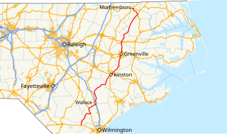
North Carolina Highway 11 (NC 11) is a primary state highway in the U.S. state of North Carolina. Traveling 193.2 miles (310.9 km), in a north–south alignment through Eastern North Carolina, it connects the towns and cities of Wallace, Kenansville, Kinston, Greenville and Murfreesboro.

North Carolina Highway 18 highway in North Carolina

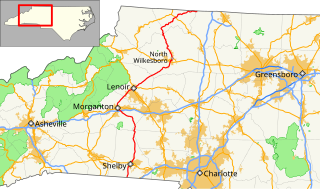
North Carolina Highway 18 (NC 18) is a primary state highway in the U.S. state of North Carolina. Traveling north–south through the Foothills region, it connects the cities of Shelby, Morganton, Lenoir, Wilkesboro and North Wilkesboro.

North Carolina Highway 101 highway in North Carolina

North Carolina Highway 101 (NC 101) is a primary state highway in the U.S. state of North Carolina that serves as a shortcut for U.S. Route 70 (US 70). It links Havelock to Beaufort, bypassing Morehead City. Most of the area along NC 101 is rural with many farms and swamps.

North Carolina Highway 39 highway in North Carolina

North Carolina Highway 39 (NC 39) is a primary state highway in the U.S. state of North Carolina. Traveling north–south, it connects the cities of Selma, Louisburg and Henderson, in the Research Triangle area.

North Carolina Highway 37 highway in North Carolina

North Carolina Highway 37 (NC 37) is a primary state highway in the northeastern part of the U.S. state of North Carolina. Traveling north–south, it serves as a connector route from U.S. Route 64 (US 64) to Hertford and from US 13 to Gatesville.

North Carolina Highway 94 highway in North Carolina

North Carolina Highway 94 (NC 94) is a primary state highway in the U.S. state of North Carolina. It runs from Hyde County in Swan Quarter to Chowan County near Edenton.

U.S. Route 220 in North Carolina highway in North Carolina

In the U.S. state of North Carolina, U.S. Route 220 is a north–south highway that connects the cities of Rockingham, Asheboro and Greensboro, in the central Piedmont.

North Carolina Highway 48 highway in North Carolina

North Carolina Highway 48 (NC 48) is a primary state highway in the U.S. state of North Carolina that principally connects the cities of Rocky Mount and Roanoke Rapids. The route offers an alternative to US 301 and I-95.

North Carolina Highway 43 highway in North Carolina

North Carolina Highway 43 (NC 43) is a primary state highway in the U.S. state of North Carolina. It connects many towns in the Coastal Plain region.

U.S. Route 76 in North Carolina highway in North Carolina

U.S. Highway 76 (US 76) is an east–west road in North Carolina running from the South Carolina state line to Wrightsville Beach. US 76 runs concurrently with US 74 for 52 miles (84 km) of the entire route in North Carolina. US 76 was first designated in North Carolina between late 1934 and 1935.

U.S. Route 221 in North Carolina highway in North Carolina

In the U.S. state of North Carolina U.S. Route 221 (US 221) is a north–south highway that travels through Western North Carolina. From Chesnee, South Carolina to Independence, Virginia, it connects the cities of Rutherfordton, Marion, Boone and Jefferson between the two out-of-state destinations. Its most memorable section, known as the Little Parkway Scenic Byway between Linville and Blowing Rock, offers area visitors a curvier alternative to the Blue Ridge Parkway and access to Grandfather Mountain.

North Carolina Highway 194 highway in North Carolina

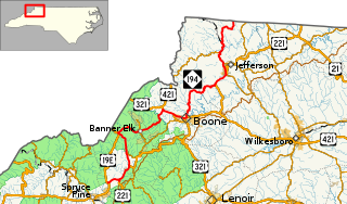
North Carolina Highway 194 (NC 194) is a primary state highway in the U.S. state of North Carolina. Primarily in the High Country, it runs from US 19E, in Ingalls, to the Virginia state line, near Helton.

Several special routes of U.S. Route 74 exist. In order from west to east they are as follows.

North Carolina Highway 65 highway in North Carolina

North Carolina Highway 65 (NC 65) is a primary state highway in the U.S. state of North Carolina. Traveling east–west within the Piedmont Triad, it connects the towns of Rural Hall, Walnut Cove, Stokesdale and Wentworth with the city of Reidsville.

North Carolina Highway 131

North Carolina Highway 131 (NC 131) is a primary state highway in the U.S. state of North Carolina. It connects the city of Bladenboro to Fayetteville, via NC 87, and Whiteville, via US 701.

References

  1. 1 2 Google (March 7, 2016). "North Carolina Highway 130" (Map). Google Maps . Google. Retrieved March 7, 2016.
  2. State Highway System of North Carolina (PDF) (Map). Cartography by NCSHC. North Carolina State Highway Commission. 1930. Retrieved March 7, 2016.
  3. North Carolina Primary Highway System (PDF) (Map). Cartography by NCSHC. North Carolina State Highway and Public Works Commission. 1940. Retrieved March 7, 2016.
  4. North Carolina County Road Survey 1949 (PDF) (Map). Cartography by NCSHC / U.S. Bureau of Public Roads. North Carolina State Highway Commission. 1949. Retrieved March 7, 2016.
  5. North Carolina Primary Highway System (PDF) (Map). Cartography by NCSHC. North Carolina State Highway and Public Works Commission. 1960. Retrieved March 7, 2016.
  6. North Carolina County Road Survey 1962 (PDF) (Map). Cartography by NCSHC / U.S. Bureau of Public Roads. North Carolina State Highway Commission. 1962. Retrieved March 7, 2016.
  7. 1 2 "Route Change (1965-10-08)" (PDF). North Carolina Department of Transportation. October 8, 1965. Retrieved March 7, 2016.
  8. "Route Change (1972-10-05)" (PDF). North Carolina Department of Transportation. October 5, 1972. Retrieved March 7, 2016.
  9. "Route Change (1975-09-01)" (PDF). North Carolina Department of Transportation. September 1, 1975. Retrieved March 7, 2016.
  10. "Route Change (1976-02-01)" (PDF). North Carolina Department of Transportation. February 1, 1976. Retrieved March 7, 2016.
  11. 1 2 "Route Change (2012-02-20)" (PDF). North Carolina Department of Transportation. February 20, 2012. Retrieved March 7, 2016.
  12. 1 2 Google (December 30, 2013). "North Carolina Highway 130 Business - Fairmont" (Map). Google Maps . Google. Retrieved December 30, 2013.
  13. Google (June 6, 2014). "North Carolina Highway 130A" (Map). Google Maps . Google. Retrieved June 6, 2014.
  14. North Carolina County Road Survey 1944 (PDF) (Map). Cartography by NCSHC / U.S. Bureau of Public Roads. North Carolina State Highway Commission. 1944. Retrieved March 7, 2016.
  15. 1 2 Google (March 7, 2016). "North Carolina Highway 130 Business - Shallotte" (Map). Google Maps . Google. Retrieved March 7, 2016.
KML file (edithelp)
    KML is from Wikidata