Fair Bluff, North Carolina

Last updated

Fair Bluff, North Carolina
Downtown Fair Bluff, North Carolina.jpg
Downtown Fair Bluff
USA North Carolina location map.svg
Red pog.svg
Fair Bluff
Location within the state of North Carolina
Coordinates: 34°18′45″N79°1′59″W / 34.31250°N 79.03306°W / 34.31250; -79.03306
Country United States
State North Carolina
County Columbus
Government
  MayorBilly Hammond
Area
[1]
  Total2.36 sq mi (6.11 km2)
  Land2.36 sq mi (6.11 km2)
  Water0.00 sq mi (0.00 km2)
Elevation
[2]
62 ft (19 m)
Population
 (2020)
  Total709
  Density300.55/sq mi (116.04/km2)
Time zone UTC-5 (Eastern (EST))
  Summer (DST) UTC-4 (EDT)
ZIP code
28439
Area codes 910, 472
FIPS code 37-22240 [3]
GNIS feature ID2406477 [2]
Website Official Fair Bluff, NC website

Fair Bluff is a town in Columbus County, North Carolina, United States that was devastated by coastal flooding from Hurricane Matthew in 2016 and inundated again by high water by Hurricane Florence in 2018.

Contents

Before the two events, the population was 951 at the 2010 census but is believed to be lower following the two disasters, some estimates going as low as 450 people. [4] The shrinking of town's size, and damage from the storms has led to a rapid decline in tax base.

History

Fair Bluff was the name originally given to a bluff overlooking the Lumber River. In 1807 plans were made to build a town upon the lands of John Wooton at the bluff to be known as Wootonton. The town was established but the name was never changed. The community was reincorporated in 1873. [5]

The Powell House was listed on the National Register of Historic Places in 1978. [6]

Agriculture has always been a mainstay of the economy in the town. Tobacco was a major commodity grown in the area. By the eighties, tobacco growing subsided. This caused a shift for the town and its citizens. [7] The downtown continued to thrive until the late 1980s when a car dealership moved from the business district to another location. Haphazard town planning saw a mixture of residential, business, and industry all over town. Tens of millions in US government grants poured into the city beginning in the mid-1980s until present day. But the town continued to decline and people left for better opportunities elsewhere. The decline in Fair Bluff was similar to neighboring towns of Tabor City, Boardman, Brunswick, Cerro Gordo, and Chadbourn.[ citation needed ] A town manager was hired to handle administrative duties of the town, [8] [9] [10] [11]

In 1999, Fair Bluff experienced a devastating flood event.

Downtown Fair Bluff, largely deserted in 2020 Fair Bluff, North Carolina.jpg
Downtown Fair Bluff, largely deserted in 2020

In 2012, the Police Chief of Fair Bluff Marty Lewis was arrested, tried and convicted for selling and delivering oxycodone and possession with the intent to sell and conspiracy to traffic while acting as police chief. He was sentenced to a minimum of seven years in prison and fined $100,000. [12] On April 9, 2015, Marty Lewis filled an appeal of his case. [13] On November 3, 2015, the verdict was unanimously affirmed by the North Carolina Court of Appeals, leaving in place the 90 to 117-month prison sentence originally imposed. Lewis will not be eligible for parole before November 2022. [14]

In 2016, the town was devastated by flooding on the Lumber River caused by Hurricane Matthew, prompting the evacuation of hundreds of residents. [15] Floodwaters reached the town hall, police department, fire department, a grocery store, and a school. [16] As of June 2018, the rebuilding effort was still underway but several hundred residents who had fled rising floodwaters never returned and a number of businesses remained shuttered. [17]

In September 2018 Fair Bluff was flooded again by the impact of Hurricane Florence, again forcing evacuations and leaving the downtown area under water again, [18] and destroying 72 homes. [19] After Florence, many buildings in the downtown area of the town lay abandoned, with no plans to reoccupy or fix them. [20] The town's only factory closed several months later, and hundreds of residents moved away. The federal government bought out some residents' properties, straining the municipal government's tax base. [16] The town government drew up plans to level the historic business district and turn it into a park, and build a new business district further away from the river. [21]

Government

Fair Bluff has a part-time town manager, assisted by the elected town mayor and town council. The town manager also works for five other deteriorating towns in Columbus County. [22] [8] [23]

Fair Bluff is in the 13th District for the North Carolina Senate, represented by Michael Walters as of September 2014, [24] and in the 46th district for the North Carolina House of Representatives, where, as of September 2021, they are represented [25] by Tabor City native and used car dealer Brenden Jones. [26]

Geography

Fair Bluff is located at 34°18′40″N79°1′57″W / 34.31111°N 79.03250°W / 34.31111; -79.03250 (34.311212, -79.032387), [27] The town lies within the Carolina Border Belt, a regional network of tobacco markets and warehouses along both sides of the North Carolina-South Carolina border. [28]

According to the United States Census Bureau, the town has a total area of 2.2 square miles (5.7 km2), all land.

Demographics

Historical population
CensusPop.Note
1880 218
1890 24311.5%
1900 32835.0%
1910 44134.5%
1920 397−10.0%
1930 806103.0%
1940 97020.3%
1950 1,0568.9%
1960 1,030−2.5%
1970 1,0390.9%
1980 1,0955.4%
1990 1,068−2.5%
2000 1,18110.6%
2010 951−19.5%
2020 709−25.4%
2022 (est.)716 [29] 1.0%
U.S. Decennial Census [30]

As of the census [3] of 2000, there were 1,181 people, 505 households, and 308 families residing in the town. The population density was 547.4 inhabitants per square mile (211.4/km2). There were 588 housing units at an average density of 272.6 per square mile (105.3/km2). The racial makeup of the town was 59.27% African American, 37.93% White, 0.68% Native American, 1.19% from other races, and 0.93% from two or more races. Hispanic or Latino of any race were 1.44% of the population.

There were 505 households, out of which 26.7% had children under the age of 18 living with them, 37.2% were married couples living together, 20.8% had a female householder with no husband present, and 39.0% were non-families. 36.0% of all households were made up of individuals, and 19.8% had someone living alone who was 65 years of age or older. The average household size was 2.32 and the average family size was 2.98.

In the town, the population was spread out, with 25.2% under the age of 18, 7.6% from 18 to 24, 24.1% from 25 to 44, 23.6% from 45 to 64, and 19.4% who were 65 years of age or older. The median age was 39 years. For every 100 females, there were 77.3 males. For every 100 females age 18 and over, there were 72.5 males.

The median income for a household in the town was $17,008, and the median income for a family was $22,969. Males had a median income of $20,764 versus $16,731 for females. The per capita income for the town was $9,829. About 31.8% of families and 37.1% of the population were below the poverty line, including 50.9% of those under age 18 and 24.3% of those age 65 or over.

Related Research Articles

<span class="mw-page-title-main">Wilson County, North Carolina</span> County in North Carolina, United States

Wilson County is a county located in the U.S. state of North Carolina. As of the 2020 census, the population was 78,784. The county seat is Wilson. The county comprises the Wilson, NC Micropolitan Statistical Area, which is also included within the Rocky Mount-Wilson-Roanoke Rapids, NC Combined Statistical Area.

<span class="mw-page-title-main">Polk County, North Carolina</span> County in North Carolina, United States

Polk County is a county located in the U.S. state of North Carolina. As of the 2020 census, the population was 19,328. Its county seat is Columbus.

<span class="mw-page-title-main">Pender County, North Carolina</span> County in North Carolina, United States

Pender County is a county located in the U.S. state of North Carolina. As of the 2020 census, the population was 60,203. Its county seat is Burgaw. Pender County is part of the Wilmington, NC Metropolitan Statistical Area.

<span class="mw-page-title-main">Pamlico County, North Carolina</span> County in North Carolina, United States

PamlicoCounty is a county located in the U.S. state of North Carolina. As of the 2020 census, the population was 12,276. Its county seat is Bayboro.

<span class="mw-page-title-main">Columbus County, North Carolina</span> County in North Carolina, United States

Columbus County is a county located in the U.S. state of North Carolina, on its southeastern border. Its county seat is Whiteville. As of the 2020 census, the population is 50,623. The 2020 census showed a loss of 12.9% of the population from that of 2010. This included an inmate prison population of approximately 2,500.

<span class="mw-page-title-main">Brunswick County, North Carolina</span> County in North Carolina, United States

Brunswick County is a county located in the U.S. state of North Carolina. It is the southernmost county in the state. As of the 2020 census, the population was 136,693. Its population was only 73,143 in 2000, making it one of the fastest-growing counties in the state. With a nominal growth rate of approximately 47% in ten years, much of the growth is centered in the eastern section of the county in the suburbs of Wilmington such as Leland, Belville and Southport. The county seat is Bolivia, which at a population of around 150 people is among the least populous county seats in the state.

<span class="mw-page-title-main">Boiling Spring Lakes, North Carolina</span> City in North Carolina, United States

Boiling Spring Lakes is a city in Brunswick County, North Carolina, United States. The population was 5,943 at the 2020 census, up from 5,372 in 2010.

<span class="mw-page-title-main">Southport, North Carolina</span> City in North Carolina, United States

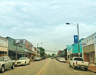
Southport is a city in Brunswick County, North Carolina, United States, near the mouth of the Cape Fear River. Its population was 3,828 as of the 2018 census. The current mayor, Rich Alt, was elected to a two-year term in November 2023.

<span class="mw-page-title-main">Yanceyville, North Carolina</span> Town in North Carolina, United States

Yanceyville is a town in and the county seat of Caswell County, North Carolina, United States. Located in the Piedmont Triad region of the state, the town had a population of 1,937 at the 2020 census.

<span class="mw-page-title-main">Chadbourn, North Carolina</span> Town in North Carolina, United States of America

Chadbourn is a town in Columbus County, North Carolina, United States. The population was 1,856 at the 2010 census.

<span class="mw-page-title-main">Lake Waccamaw, North Carolina</span> Town in North Carolina, United States

Lake Waccamaw is a town in Columbus County, North Carolina, United States. The 2010 census population was 1,480. Originally home to Native Americans, Europeans later colonized Lake Waccamaw in the 18th century. The Europeans built naval stores and the discovery of turpentine oil led to the Wilmington-Manchester railroad track being created. A shingle company was later converted to a lumber company. In 1910, a group of townspeople created the Waccamaw Club.

<span class="mw-page-title-main">Tabor City, North Carolina</span> Town in the United States

Tabor City is a town in Columbus County, North Carolina, United States. It is the southernmost town in the county. It is located just north of the North Carolina/South Carolina line, about 39 miles (63 km) north of Myrtle Beach, South Carolina, and is just north of Loris, South Carolina. The population was 2,511 as of the 2010 census.

<span class="mw-page-title-main">Whiteville, North Carolina</span> City in North Carolina, United States

Whiteville is a city in Columbus County, North Carolina, United States. The population was 5,394 at the 2010 census. It is the most populous city in Columbus County and is the county seat.

<span class="mw-page-title-main">Carolina Beach, North Carolina</span> Town in North Carolina, United States

Carolina Beach is a beach town in New Hanover County, North Carolina, United States, situated about 12 miles (19 km) south of Wilmington International Airport in southeastern coastal North Carolina. As of the 2020 census, the city population was 6,564. It is part of the Wilmington metropolitan area. The community of Wilmington Beach was annexed by the town in 2000.

<span class="mw-page-title-main">Castle Hayne, North Carolina</span> CDP in North Carolina, United States

Castle Hayne is a census-designated place (CDP) in New Hanover County, North Carolina, United States. The population was 1,202 at the 2010 census, up from 1,116 in 2000. It is part of the Wilmington Metropolitan Statistical Area.

<span class="mw-page-title-main">Swansboro, North Carolina</span> Town in North Carolina, United States

Swansboro is a town in Onslow County, North Carolina, United States, located along the Crystal Coast. In 2020, the population was 3,744.

<span class="mw-page-title-main">Lumberton, North Carolina</span> City in North Carolina, United States

Lumberton is a city in Robeson County, North Carolina, United States. As of 2020, its population was 19,025. It is the seat of Robeson County's government.

<span class="mw-page-title-main">Seven Springs, North Carolina</span> Town in North Carolina, United States

Seven Springs is a town in Wayne County, North Carolina, United States. It lies next to the Neuse River. The 2012 population was estimated at 111. It is included in the Goldsboro, North Carolina Metropolitan Statistical Area.

<span class="mw-page-title-main">Mullins, South Carolina</span> City in South Carolina, United States

Mullins is a city in Marion County, South Carolina, United States. As of the 2010 census, the city population was 4,663.

<span class="mw-page-title-main">Nichols, South Carolina</span> Town in South Carolina, United States

Nichols is a town in Marion County, South Carolina, United States. The population was 368 at the 2010 census.

References

  1. "ArcGIS REST Services Directory". United States Census Bureau. Retrieved September 20, 2022.
  2. 1 2 U.S. Geological Survey Geographic Names Information System: Fair Bluff, North Carolina
  3. 1 2 "U.S. Census website". United States Census Bureau . Retrieved January 31, 2008.
  4. Graff, Michael (July 21, 2019). "The town fighting the climate crisis to stay afloat, one hurricane at a time". The Guardian. ISSN   0261-3077 . Retrieved July 30, 2019.
  5. Powell 1976, p. 166.
  6. "National Register Information System". National Register of Historic Places . National Park Service. July 9, 2010.
  7. "Unemployment continued to rise in 1982 as the recession deepened" (PDF). Bureau of Labor Statistics. U.S. Bureau of Labor. Retrieved October 15, 2018.
  8. 1 2 McAdams, Ann. "Columbus Co. man works on 5 town payrolls". wect.com.
  9. "Fair Bluff Town Manager doesn't like to see himself on TV; Won't address employee who wrecked car". February 7, 2013.
  10. "Al Leonard, Jr". Ballotpedia.
  11. Walton, Brett (June 5, 2019). "The Rural Dilemma: Q&A With Al Leonard, Fair Bluff Town Manager".
  12. "VERDICT: Jury reaches verdict in Marty Lewis trial". wect.com.
  13. Bynum, Elizabeth (May 18, 2015). "Former Fair Bluff police chief appealing drug convictions". WWAY . Retrieved October 9, 2019.
  14. "NC Court of Appeals affirms guilty verdict in former police chief's trafficking case". WECT . Retrieved October 9, 2019.
  15. "Flooding continues across area; Fair Bluff hardest hit; Waccamaw 'stable'". October 12, 2016.
  16. 1 2 Flavelle, Christopher; Belleme, Mike (September 2, 2021). "Climate Change Is Bankrupting America's Small Towns". The New York Times.
  17. Futch, Michael. "20 months after Matthew, Fair Bluff 'like a ghost town'". The Fayetteville Observer. Retrieved September 24, 2018.
  18. "Fair Bluff hit hard by second hurricane in two years" . Retrieved September 24, 2018.
  19. Martin, Edward (October 1, 2019). "Columbus County claws its way back from Florence's strike". Business North Carolina. Retrieved January 16, 2023.
  20. Ross, Gabe. "3 Storms in 20 years: a look at Floyd, Matthew and Florence's impact on Fair Bluff". WECT . Retrieved July 30, 2019.
  21. Schofield, Ivey (July 27, 2022). "Bringing southeastern North Carolina back to life, one downtown at a time". Border Belt Independent. Retrieved November 5, 2022.
  22. "The Rural Dilemma: Q&A with al Leonard, Fair Bluff Town Manager". June 5, 2019.
  23. "Fair Bluff Town Manager doesn't like to see himself on TV; Won't address employee who wrecked car". February 7, 2013.
  24. NC General Assembly webmasters. "North Carolina General Assembly – N.C. Senators (2013–2014 Session)". ncga.state.nc.us. Archived from the original on March 8, 2018. Retrieved December 6, 2014.
  25. NC General Assembly webmasters. "North Carolina General Assembly – N.C. House of Representatives Members (2013–2014 Session)". ncga.state.nc.us. Archived from the original on March 8, 2018. Retrieved December 6, 2014.
  26. "Home". Representative Brenden Jones.
  27. "US Gazetteer files: 2010, 2000, and 1990". United States Census Bureau. February 12, 2011. Retrieved April 23, 2011.
  28. Yeargin, W.W. (2006). "Tobacco Belts". NCPedia. North Carolina Government & Heritage Library. Retrieved July 21, 2022.
  29. "Annual Estimates of the Resident Population for Incorporated Places in North Carolina: April 1, 2020 to July 1, 2022". Census.gov. Retrieved April 23, 2024.
  30. "Census of Population and Housing". Census.gov. Retrieved June 4, 2015.

Works cited