
Polk County is a county located in the U.S. state of North Carolina. As of the 2020 census, the population was 19,328. Its county seat is Columbus. The county was formed in 1855 from parts of Henderson and Rutherford counties. It was named for William Polk, a colonel in the American Revolutionary War. The Tryon International Equestrian Center, close to the community of Mill Spring was the location of the 2018 FEI World Equestrian Games.

Pender County is a county located in the U.S. state of North Carolina. As of the 2020 census, the population was 60,203. Its county seat is Burgaw. Pender County is part of the Wilmington, NC Metropolitan Statistical Area.

Nemaha County is a county located in the northeastern part of the U.S. state of Kansas. Its county seat is Seneca. As of the 2020 census, the county population was 10,273. The county was named for the Nemaha River.
Smiths Station is a city in Lee County, Alabama. It is part of the Columbus metropolitan area, Georgia. At the time of the 2000 census, it was still a census-designated place (CDP), and its population was 6,756. The area that incorporated as Smiths Station in 2001 was much smaller than the CDP, and contained a population of 4,926 by the 2010 census. Smiths Station, known to locals as "Smiths", is a bedroom community of Columbus, Georgia and Phenix City, Alabama. Smiths Station High School has an enrollment of over 1,800 students and is the 11th-largest high school in the state.

Windsor is a home rule municipality in Larimer and Weld counties in the U.S. state of Colorado. According to the 2020 census, the population of the town was 32,716. Windsor is located in the Northern Colorado region. Someone who lives in the municipality is known as a "Winsord."

Experiment is a census-designated place (CDP) in Spalding County, Georgia, United States. The population was 3,233 at the 2000 census.

East Bernstadt is a census-designated place (CDP) and coal town in Laurel County, Kentucky, United States. The population was 716 at the 2010 census, down from 774 at the 2000 census.
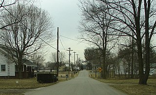
Saxapahaw is a census-designated place (CDP) and unincorporated area in Alamance County, North Carolina, United States. It is part of the Burlington, North Carolina Metropolitan Statistical Area. The population was 1,648 at the 2010 census.

Moravian Falls is a census-designated place (CDP) in Wilkes County, North Carolina, United States. The population was 1,802 as of the 2020 census.
Campbelltown is an unincorporated community and census-designated place (CDP) in Lebanon County, Pennsylvania, United States. The population was 3,616 at the 2010 census. It is located east of Hershey at the intersection of U.S. Route 322 and Pennsylvania Route 117 and is located in the Harrisburg metropolitan area.
Five Forks is a census-designated place (CDP) in Greenville County, South Carolina, United States. The population was 17,737 at the 2020 census, up from 14,140 in 2010, and 8,064 in 2000. It is a growing, affluent suburb of Greenville and is part of the Greenville–Mauldin–Easley Metropolitan Statistical Area.
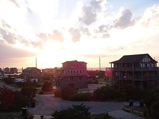
Avon is an unincorporated community and census-designated place (CDP) in Dare County in the U.S. state of North Carolina. As of the 2010 census, it had a permanent population of 776.

The 1994 Palm Sunday tornado outbreak was the third notable US tornado outbreak to occur on Palm Sunday and the second to take place in the Southeastern United States. The outbreak produced 29 tornadoes from Texas to North Carolina, killing 40 people and injuring 491, and causing $140 million in damage. The deadliest storm of the outbreak, as well as in the US in 1994, was an F4 tornado that devastated Piedmont, Alabama. It struck the Goshen United Methodist Church right in the middle of the Palm Sunday service, collapsing the roof on the congregation and killing 20 people inside, including the Rev. Kelly Clem's 4-year-old daughter Hannah. Two other houses of worship were also destroyed mid-service. The supercell that formed this tornado tracked for 200 miles (322 km) to South Carolina.
Peggs is an unincorporated community and census-designated place (CDP) in Cherokee County, Oklahoma, United States. It had a population of 813 at the 2010 census, compared to 814 at the 2000 census. A large minority of its residents are Native American, most of them members of 10 tribal groups such as the Cherokee Nation and the Muscogee Creek Nation.
Summertown is an unincorporated community and census-designated place (CDP) in Lawrence County, Tennessee, United States. The population of Summertown was 866 at the 2010 census. The town has a ZIP Code of 38483. Some rural areas in neighboring Lewis and Maury counties also use a "Summertown" mailing address, but their population is not included in the Census figures.
Evergreen is an unincorporated community and census-designated place (CDP) in Tatums Township, Columbus County, North Carolina, United States. It lies on North Carolina Highway 242, north of U.S. Route 74 and NC 130, at an elevation of 108 feet (33 m). The population was 420 at the 2010 census.
Linnsburg is a small unincorporated community and census-designated place (CDP) in Walnut Township, Montgomery County, in the U.S. state of Indiana. The town is a former whistle stop on the Monon branch and still has active rail service today from Nucor Steel to Avon.
Hallsboro is an unincorporated community and census-designated place (CDP) in Columbus County, in southeastern North Carolina, United States. As of the 2010 census it had a population of 465.

This page documents the tornadoes and tornado outbreaks of 1964, primarily in the United States. Most tornadoes form in the U.S., although some events may take place internationally. Tornado statistics for older years like this often appear significantly lower than modern years due to fewer reports or confirmed tornadoes.
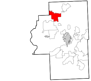
Long Creek is an unincorporated community and census-designated place (CDP) in Pender County, North Carolina, United States. It was first listed as a CDP in the 2020 census with a population of 277.


