North Carolina Highway 131

Last updated

NC 131.svg

North Carolina Highway 131
NC 131 map.svg
Route information
Maintained by NCDOT
Length 24.5 mi [1] (39.4 km)
Existed 1949 – present
Major junctions
South endUS 701.svg US 701 near Whiteville
North endNC 87.svg NC 87 in Tar Heel
Location
Counties Columbus, Bladen
Highway system
NC 130.svg NC 130 NC 132 NC 132.svg

North Carolina Highway 131 (NC 131) is a primary state highway in the U.S. state of North Carolina. It connects the city of Bladenboro to Fayetteville, via NC 87, and Whiteville, via US 701.

A state highway, state road, or state route is usually a road that is either numbered or maintained by a sub-national state or province. A road numbered by a state or province falls below numbered national highways in the hierarchy. Roads maintained by a state or province include both nationally numbered highways and un-numbered state highways. Depending on the state, "state highway" may be used for one meaning and "state road" or "state route" for the other.

North Carolina State of the United States of America

North Carolina is a state in the southeastern region of the United States. It borders South Carolina and Georgia to the south, Tennessee to the west, Virginia to the north, and the Atlantic Ocean to the east. North Carolina is the 28th-most extensive and the 9th-most populous of the U.S. states. The state is divided into 100 counties. The capital is Raleigh, which along with Durham and Chapel Hill is home to the largest research park in the United States. The most populous municipality is Charlotte, which is the second-largest banking center in the United States after New York City.

Bladenboro, North Carolina Town in North Carolina, United States

Bladenboro is a town in Bladen County, North Carolina, in the United States. As of the 2010 census, the town population was 1,750.

Contents

Route description

NC 131 is a two-lane rural highway that begins at US 701 north of Whiteville. In Bladenboro, it shares concurrencies with NC 242 and NC 410 along its Main Street crossing NC 211 Business at Seaboard Street. It soon splits from NC 242, which continues north to Elizabethtown, followed by crossing NC 211 By-Pass, before leaving Bladenboro. Five miles (8.0 km) later, it splits from NC 410, which continues north to Dublin. At NC 41, NC 131 has a brief .1-mile (0.16 km) overlap; it is noticeable that the routing here was reconfigured to slowdown NC 131 at this location.[ citation needed ] At the end of its journey, NC 131 meets with NC 87, in Tar Heel; where travelers can continue on to Fayetteville or Elizabethtown.

Concurrency (road) instance of one physical road bearing two or more different highways

A concurrency in a road network is an instance of one physical roadway bearing two or more different route numbers. When two roadways share the same right-of-way, it is sometimes called a common section or commons. Other terminology for a concurrency includes overlap, coincidence, duplex, triplex, multiplex, dual routing or triple routing.

North Carolina Highway 242 highway in North Carolina

North Carolina Highway 242 (NC 242) is a primary state highway in the U.S. state of North Carolina. It traverses from Cerro Gordo to Benson, connecting the cities of Bladenboro, Elizabethtown, and Roseboro.

North Carolina Highway 410

North Carolina Highway 410 (NC 410) is a primary state highway in the U.S. state of North Carolina. It serves as the central north–south highway in Columbus and Bladen Counties.

NC 131 goes through predominantly forested or farmlands in the area, with Bladenboro being the only urban location along its route.

History

NC 131 was established in 1949 as a new primary routing from US 701 north of Whiteville to NC 87 in Tar Heel. [2] In 1970, NC 131 was rerouted onto a new road east of downtown Tar Heel. [3] In 2015, NC 131 was realigned on new road and brief overlap with NC 41, eliminating an intersection; old alignment was downgraded to secondary roads, with some partial removal of roadway. [4]

Junction list

CountyLocationmi [1] kmDestinationsNotes
Columbus 0.00.0US 701.svg US 701 (James B. White Highway) Clarkton, Whiteville
Bladen Bladenboro 9.214.8NC 242.svgNC 410.svg NC 242 / NC 410 south (Main Street) Chadbourn, Evergreen, Boardman South end of NC 242/NC 410 overlap
9.815.8Business plate.svg
NC 211.svg NC 211 Bus. (Seaboard Street)
10.016.1NC 242.svg NC 242 north Elizabethtown North end of NC 242 overlap
10.717.2NC 211.svg NC 211  Clarkton, Lumberton
15.625.1NC 410.svg NC 410 north Dublin North end of NC 410 overlap
17.428.0NC 41.svg NC 41 west Lumberton West end of NC 41 overlap
17.528.2NC 41.svg NC 41 east Elizabethtown East end of NC 41 overlap
Tar Heel 24.539.4NC 87.svg NC 87  Elizabethtown, Fayetteville
1.000 mi = 1.609 km; 1.000 km = 0.621 mi

Related Research Articles

U.S. Route 701 is an auxiliary route of US 1 in the U.S. states of South Carolina and North Carolina. The U.S. Highway runs 171.45 miles (275.92 km) from US 17 and US 17 Alternate in Georgetown, South Carolina north to US 301, North Carolina Highway 96, and Interstate 95 (I-95) near Four Oaks, North Carolina. US 701 serves the Pee Dee region of South Carolina and the southern and central portions of Eastern North Carolina. The highway connects Georgetown and Conway in South Carolina with the North Carolina cities of Whiteville, Elizabethtown, Clinton, and a short distance north of its terminus, Smithfield. US 701 has four business routes in North Carolina, including those through Tabor City, Whiteville, Clarkton, and Clinton.

North Carolina Highway 100 highway in North Carolina

North Carolina Highway 100 (NC 100) is a primary state highway in the U.S. state of North Carolina. The route travels between Whitsett and Burlington, connecting the cities of Gibsonville and Elon.

North Carolina Highway 82 highway in North Carolina

North Carolina Highway 82 (NC 82) is a primary state highway in the U.S. state of North Carolina. The highway traverses where the Battle of Averasborough took place and connects the towns of Erwin, Godwin and Falcon. Though the road is signed as east and west, it runs physically north from Erwin to US 13 to the south near Cooper.

North Carolina Highway 211 highway in North Carolina

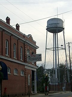
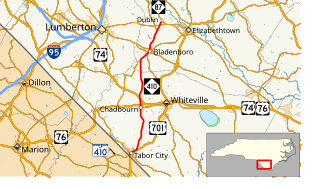
North Carolina Highway 211 (NC 211) is a 162.5-mile-long (261.5 km) primary state highway in the U.S. state of North Carolina. It traverses mostly through the Sandhills and Coastal Plain regions of the state; connecting the cities of Candor, Aberdeen, Raeford, Lumberton, Bladenboro, and Southport.

North Carolina Highway 50 highway in North Carolina

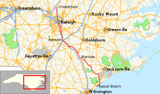
North Carolina Highway 50 (NC 50) is a primary state highway in the U.S. state of North Carolina. It traverses north–south, from Topsail Beach to Creedmoor, connecting the cities of Warsaw, Newton Grove, Benson, and Raleigh.

North Carolina Highway 49 highway in North Carolina

North Carolina Highway 49 (NC 49) is a primary state highway in the U.S. state of North Carolina. It traverses much of the Piedmont region of North Carolina.

North Carolina Highway 20 highway in North Carolina

North Carolina Highway 20 is a 27-mile (43 km) North Carolina state highway that runs through Hoke, Robeson and Bladen counties. It serves as a major road in each of the three incorporated communities through which it passes. The route is co-designated as St. Pauls Road in Raeford, Main Street in Lumber Bridge, and Broad Street in St. Pauls.

North Carolina Highway 22 highway in North Carolina

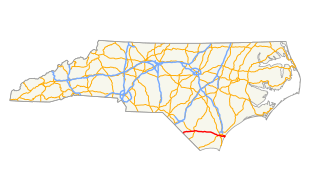
North Carolina Highway 22 is a North Carolina state highway that runs in the central-north part of the state. It runs between Southern Pines and Climax. The route is signed north–south, and is 59 miles (95 km) in length.

North Carolina Highway 87 highway in North Carolina

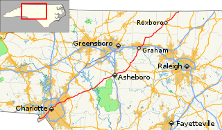
North Carolina Highway 87 (NC 87) is a primary state highway in the U.S. state of North Carolina. NC 87 begins in the Atlantic coastal town of Southport and crosses into Virginia at the Virginia state line five miles (8 km) north of Eden in Rockingham County. At 240 miles (390 km) in length, NC 87 is the second longest state highway in the U.S. state of North Carolina. Labeled as a north–south route, NC 87 travels along a relatively straight southeast–northwest path, connecting Cape Fear region with the Piedmont and connecting the cities of Fayetteville, Sanford, and Burlington.

North Carolina Highway 130 highway in North Carolina

North Carolina Highway 130 (NC 130) is a primary state highway in the U.S. state of North Carolina. The highway serves the towns and rural communities in southern Robeson County, acts as a direct route between Whiteville and Shallotte through the Green Swamp, and provides access to Holden Beach.

North Carolina Highway 903 highway in North Carolina

North Carolina Highway 903 (NC 903) is a primary state highway in the U.S. state of North Carolina. It serves as predominantly rural highway in the Inner Banks region and arterial road in and around Greenville. The road covers a total of 200 miles (320 km), in a zigzag pattern through the state.

U.S. Route 17 in North Carolina highway in North Carolina

In the U.S. state of North Carolina U.S. Route 17 (US 17) is a north–south highway that is known as the Coastal Highway in the southeastern half of the state and the Ocean Highway in other areas. The route enters the state from South Carolina near Calabash, and leaves in the vicinity of the Great Dismal Swamp National Wildlife Refuge in Virginia. Between the US 64 freeway and the Virginia state line, US 17 is a four-lane divided highway with speed limits varying between 45 miles per hour (72 km/h) and 70 miles per hour (110 km/h).

U.S. Route 76 in North Carolina highway in North Carolina

U.S. Highway 76 (US 76) is an east–west road in North Carolina running from the South Carolina state line to Wrightsville Beach. US 76 runs concurrently with US 74 for 52 miles (84 km) of the entire route in North Carolina. US 76 was first designated in North Carolina between late 1934 and 1935.

North Carolina Highway 53 highway in North Carolina

North Carolina Highway 53 (NC 53) is a 126-mile-long (203 km) primary state highway in the U.S. state of North Carolina that mainly runs west–east in the eastern part of the state.

North Carolina Highway 21 (NC 21) was a primary state highway in the U.S. state of North Carolina. At its height, it traversed from the South Carolina state line to Raleigh, connecting the cities of Fayetteville, and Lillington.

Several special routes of U.S. Route 701 exist, from South Carolina to North Carolina. In order from south to north, separated by type, they are as follows.

References

  1. 1 2 Google (June 11, 2014). "North Carolina Highway 131" (Map). Google Maps . Google. Retrieved June 11, 2014.
  2. North Carolina Official Highway Map (PDF) (Map). Cartography by NCDOT. North Carolina Department of Transportation. 1951. Retrieved June 11, 2014.
  3. "Route Change (1970-10-01)" (PDF). North Carolina Department of Transportation. October 1, 1970. Retrieved June 11, 2014.
  4. "Route Change (2015-08-20)" (PDF). North Carolina Department of Transportation. August 20, 2015. Retrieved February 15, 2016.
KML file (edithelp)
KML is from Wikidata