
The London Borough of Hammersmith and Fulham is a London borough in West London and which also forms part of Inner London. The borough was formed in 1965 as the London Borough of Hammersmith from the merger of the former Metropolitan Boroughs of Fulham and Hammersmith. The name was changed to Hammersmith and Fulham in 1979. The borough borders Brent to the north, the Royal Borough of Kensington and Chelsea to the east, Wandsworth to the south, Richmond upon Thames to the south west, and Hounslow and Ealing to the west.

Fulham is an ancient and historic settlement within the London Borough of Hammersmith & Fulham in West London, England, 3.6 miles (5.8 km) southwest of Charing Cross. It lies in a loop on the north bank of the River Thames, bordering Hammersmith, Kensington and Chelsea, with which it shares the area known as West Brompton. Over the Thames Fulham faces Wandsworth, Putney, the London Wetland Centre in Barnes in the London Borough of Richmond upon Thames.
The Metropolitan Borough of Fulham was a metropolitan borough in the County of London between 1900 and 1965, when it was merged with the Metropolitan Borough of Hammersmith to form the London Borough of Hammersmith and Fulham. It was a riverside borough, and comprised the many centuries-long definition of Fulham so included parts often considered of independent character today Walham Green, Parsons Green, Hurlingham, Sands End and that part of Chelsea Harbour west of Counter's Creek. The SW6 postal district approximately follows this as does the direct, though less empowered, predecessor Fulham civil parish.

Lillie Rec, is a park located in London Borough of Hammersmith and Fulham, 0.8 mile (1.25 km) south of Hammersmith tube station, and at the junction of Lillie Road and Fulham Palace Road.
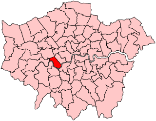
Hammersmith and Fulham was a constituency represented in the House of Commons of the Parliament of the United Kingdom. It elected one Member of Parliament (MP) by the first past the post system of election. The constituency was abolished at the 2010 general election with its wards being split between two new constituencies of Chelsea and Fulham & Hammersmith.

Parsons Green is a mainly residential district in the London Borough of Hammersmith and Fulham. The Green itself, which is roughly triangular, is bounded on two of its three sides by the New King's Road section of the King's Road, A308 road and Parsons Green Lane. The wider neighbourhood is bounded by the Harwood and Wandsworth Bridge Roads, A217 road to the east and Munster Road to the west, while the Fulham Road, A3219 road may be said to define its northern boundary. Its southern boundary is less clearly defined as it merges quickly and imperceptibly with the Sulivan Court Estate and Hurlingham.

The London Borough of Hammersmith & Fulham, an Inner London borough, has 231 hectares of parks and open spaces that are accessible to the general public, 159 hectares being within parks and 52.5 hectares within cemeteries and churchyards. Wormwood Scrubs and Scrubs Wood, located in the north of the Borough account for 42 hectares and Fulham Palace and Bishop's Park grounds contain another 14 hectares of open space. Private open space includes Hurlingham, Fulham and Queen's Club in West Kensington.

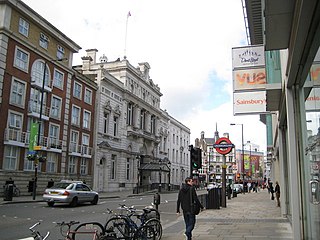
West Kensington, formerly North End, is an area in the ancient parish of Fulham, in the London Borough of Hammersmith and Fulham, England, 3.4 miles (5.5 km) west of Charing Cross. It covers most of the London postal area of W14, including the area around Barons Court tube station, and is defined as the area between Lillie Road and Hammersmith Road to the west, Fulham Palace Road to the south, Hammersmith to the north and West Brompton and Earl's Court to the east. The area is bisected by the major London artery the A4, locally known as the Talgarth Road. Its main local thoroughfare is the North End Road.

Fulham Road is a street in London, England, which comprises the A304 and part of the A308.

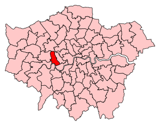
Chelsea and Fulham is a constituency in Greater London represented in the House of Commons of the UK Parliament by Ben Coleman of the Labour Party.
Hammersmith was a parliamentary constituency in the House of Commons of the UK Parliament represented from 2010 until its abolition for the 2024 general election by Andy Slaughter, a member of the Labour Party.

West Brompton is an area of west London, England, that straddles the boundary between the London Borough of Hammersmith and Fulham and Royal Borough of Kensington and Chelsea. The centuries-old boundary traced by Counter's Creek, probably marked the eastern edge of Fulham Manor since Saxon times and is now partly lost beneath the West London Line railway.
Barons Court was a constituency of the House of Commons of the Parliament of the United Kingdom from 1955 to 1974. It was represented by one Member of Parliament (MP), elected by the first-past-the-post system of election.

Walham Green is the historic name of an English village, now part of inner London, in the parish of Fulham in the County of Middlesex. It was located between the hamlet of North End to the north, and Parsons Green to the south. To the east it was bounded by Counter's Creek, the historical boundary with the parish of Chelsea, and to the south-east is Sands End.

Talgarth Road is a dual carriageway in the London Borough of Hammersmith and Fulham and is a designated part of the A4, running through West London, England on the road to Heathrow Airport. It starts in West Kensington at its junction with North End Road and West Cromwell Road running near Barons Court tube station before ending at Hammersmith Broadway.

Sir John Scott Lillie was an Anglo-British decorated officer of the British Army and Portuguese Army who fought in the Peninsular War (1808–1814). He was a landowner, entrepreneur and inventor. He was Deputy Lieutenant of the County of Middlesex and Chairman of the Middlesex Quarter Sessions, a freemason, a radical politician and supporter of the great Irish statesman Daniel O'Connell. He was an early antivivisectionist and writer.

Lillie Bridge is a road bridge that links Old Brompton Road in the Royal Borough of Kensington and Chelsea with Lillie Road in the London Borough of Hammersmith & Fulham. It crosses two railways: the West London Line on the London Overground and the Wimbledon branch of the London Underground at West Brompton station.

Lillie Road is a major street in the north of Fulham, in the London Borough of Hammersmith and Fulham. Named for the Peninsular War veteran, John Scott Lillie, it is a mixed residential and commercial thoroughfare, and is the westerly continuation of the Old Brompton Road, the A3218 road, running from Lillie Bridge to the A219 Fulham Palace Road. Its main junctions are with North End Road and with Munster Road at Fulham Cross.
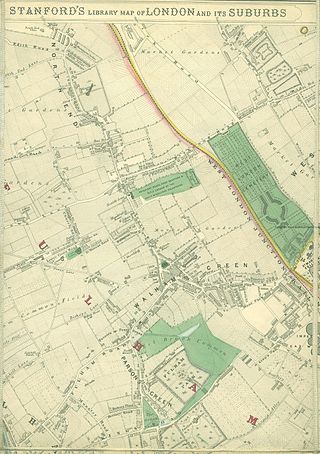
North End was, until the last quarter of the 19th-century, a scattered hamlet among the fields and market gardens, between Counter's Creek and Walham Green in the Parish of Fulham in the County of Middlesex.


