North Perth, Western Australia

Last updated

North Perth
Perth,  Western Australia
North Perth Town Hall6.jpg
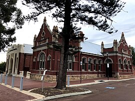
The heritage listed North Perth Town Hall
North Perth, Western Australia
Coordinates 31°55′41″S115°51′11″E / 31.928°S 115.853°E / -31.928; 115.853
Population9,623 (SAL 2021) [1]
Postcode(s) 6006
Area3.1 km2 (1.2 sq mi)
Location4 km (2 mi) N of the Perth CBD
LGA(s) City of Vincent
State electorate(s) Perth
Federal division(s) Perth
Suburbs around North Perth:
Joondanna and Mount Hawthorn Coolbinia and Menora Mount Lawley
Leederville North Perth Mount Lawley
West Perth Perth Highgate

North Perth is a suburb of Perth, Western Australia, located within the City of Vincent.

Contents

This old, established suburb three kilometres north of the Perth central business district is a place of mainly solid brick homes built from the early 1900s, many of which are now undergoing extensive renovations in line with the nationwide trend toward close-to-the-city living. It is home to various small shops and cafes, as well as the Rosemount Hotel. Beatty Park Leisure Centre was built (as Beatty Park Aquatic Centre) for the Perth Commonwealth Games in 1962 in Vincent Street.

North Perth is home to North Perth Primary School and Kyilla Primary School. North Perth Primary School was established in 1899 and by 1921 was the largest primary school in the state. [2]

According to the 2016 Census data, North Perth has a median age of 37 years, with 14.0% over the age of 65. [3] The residents have a median personal income per week of $943, median household income of $2,074 and median family income of $2,616. [3] This is a higher median income in all categories than Australia as a whole ($724, $1,910 and $1,595 respectively). [3]

Transport

Bus

Bus routes serving Charles Street:

Bus routes serving Fitzgerald Street:

See also

Related Research Articles

Balga is a suburb of Perth, the capital city of Western Australia, 13 kilometres (8 mi) north of Perth city's central business district (CBD). Its local government area is the City of Stirling. Mark Irwin is the current mayor.

Dianella is a suburb of Perth, Western Australia. It is within the local government area of the City of Stirling.

<span class="mw-page-title-main">Elizabeth Quay bus station</span> Bus station in Perth, Western Australia

Elizabeth Quay bus station, formerly the Esplanade Busport, is a Transperth bus station, located at the southern edge of the Perth CBD in Western Australia, next to the Perth Convention Exhibition Centre and Elizabeth Quay railway station. It has 35 stands and is served by 55 Transperth routes operated by Path Transit, Swan Transit and Transdev WA. It is also served by South West Coach Lines services.

<span class="mw-page-title-main">Kensington, Western Australia</span> Suburb of Perth, Western Australia

Kensington is a residential suburb 3 km from Perth's central business district. Kensington is located within the City of South Perth and Town of Victoria Park local government areas.

<span class="mw-page-title-main">Ardross, Western Australia</span> Suburb of Perth, Western Australia

Ardross is a suburb of Perth, Western Australia, located within the City of Melville. It was once an area of land acquired by the Scotsman, Sir Alexander Percival Matheson in 1896. In Matheson's subdivision of the adjoining suburb of Applecross, he created "Ardross Street" naming it after either the town of Ardrossan on the Scottish west coast or Ardross Castle, located about 40 kilometres north of Inverness. The suburb derives its name from this street.

<span class="mw-page-title-main">Alexander Heights, Western Australia</span> Suburb of Perth, Western Australia

Alexander Heights is a suburb of Perth, Western Australia within the City of Wanneroo.

<span class="mw-page-title-main">Welshpool, Western Australia</span> Suburb of Perth, Western Australia

Welshpool is an inner southeastern suburb of Perth, Western Australia, located mostly within the City of Canning and partially within the Town of Victoria Park.

<span class="mw-page-title-main">Champion Lakes, Western Australia</span> Suburb of Perth, Western Australia

Champion Lakes is a suburb of Perth, Western Australia in the City of Armadale.

<span class="mw-page-title-main">Kelmscott, Western Australia</span> Suburb of Perth, Western Australia

Kelmscott is a southeastern suburb of Perth, Western Australian within the local government area of the City of Armadale. It is 23 kilometres (14 mi) southeast of Perth along the Albany Highway.

<span class="mw-page-title-main">Applecross, Western Australia</span> Suburb of Perth, Western Australia

Applecross is an affluent riverside suburb of Perth, Western Australia, bounded by Canning Highway and the Swan River. It is located within the City of Melville.
<span class="mw-page-title-main">Canning Vale, Western Australia</span> Suburb of Perth, Western Australia

Canning Vale is a southern suburb of Perth, 22 km (13.7 mi) from the central business district. Its local government areas are the City of Canning and the City of Gosnells.

Wembley is a western suburb of Perth, Western Australia, located within the Town of Cambridge. Its postcode is 6014.

<span class="mw-page-title-main">Bentley, Western Australia</span> Suburb of Perth, Western Australia

Bentley is a southern suburb of Perth, the capital city of Western Australia, 8 kilometres (5.0 mi) southeast of Perth's central business district. Its local government areas are the City of Canning and the Town of Victoria Park. Bentley is home to the main campus of Curtin University and Technology Park.

<span class="mw-page-title-main">Cannington, Western Australia</span> Suburb of Perth, Western Australia

Cannington is a southern suburb of Perth, Western Australia. Its local government area is the City of Canning.

<span class="mw-page-title-main">Queens Park, Western Australia</span> Suburb of Perth, Western Australia

Queens Park is a suburb of Perth, Western Australia, located within the City of Canning. Its postcode is 6107.

St James is a suburb shared between the Town of Victoria Park and the City of Canning in the Perth metropolitan area.

<span class="mw-page-title-main">Willetton, Western Australia</span> Suburb of Perth, Western Australia

Willetton is a large southern suburb of Perth, Western Australia. Its local government area is the City of Canning.

<span class="mw-page-title-main">Pearsall, Western Australia</span> Suburb of Perth, Western Australia

Pearsall is a suburb of Perth, Western Australia in the City of Wanneroo. Until the late 1990s it was the southernmost part of the suburb of Wanneroo.

<span class="mw-page-title-main">Nedlands, Western Australia</span> Suburb of Perth, Western Australia

Nedlands is a western suburb of Perth, the capital city of Western Australia. It is a part of the local government areas of the City of Nedlands and the City of Perth. It is about 7 kilometres (4 mi) from the Perth CBD via either Thomas Street or Mounts Bay Road.

<span class="mw-page-title-main">Perth Busport</span> Underground bus station in Perth, Western Australia

Perth Busport is an underground bus station, located underneath Wellington Street, Perth, Western Australia. It was officially opened by then Premier of Western Australia Colin Barnett and then Minister for Transport Dean Nalder on 13 July 2016.
References

  1. Australian Bureau of Statistics (28 June 2022). "North Perth (suburb and locality)". Australian Census 2021 QuickStats. Retrieved 28 June 2022.  OOjs UI icon edit-ltr-progressive.svg
  2. "Our History". North Perth Primary School website. Retrieved 3 September 2022.
  3. 1 2 3 Australian Bureau of Statistics (27 June 2017). "North Perth (State Suburb)". 2016 Census QuickStats. Retrieved 19 April 2018. OOjs UI icon edit-ltr-progressive.svg
  4. "Route 402". Bus Timetable 58 (PDF). Transperth. 21 June 2023 [effective from 16 July 2023].
  5. "Route 403". Bus Timetable 58 (PDF). Transperth. 21 June 2023 [effective from 16 July 2023].
  6. "Route 404". Bus Timetable 58 (PDF). Transperth. 21 June 2023 [effective from 16 July 2023].
  7. "Route 406". Bus Timetable 71 (PDF). Transperth. 8 February 2023 [effective from 12 March 2023].
  8. "Route 990". Bus Timetable 206 (PDF). Transperth. 11 January 2024 [effective from 28 January 2024].
  9. "Route 370". Bus Timetable 72 (PDF). Transperth. 24 October 2023 [effective from 17 December 2023].
  10. "Route 384". Bus Timetable 72 (PDF). Transperth. 24 October 2023 [effective from 17 December 2023].
  11. "Route 385". Bus Timetable 82 (PDF). Transperth. 21 June 2023 [effective from 16 July 2023].
  12. "Route 386". Bus Timetable 82 (PDF). Transperth. 21 June 2023 [effective from 16 July 2023].
  13. "Route 387". Bus Timetable 81 (PDF). Transperth. 11 January 2024 [effective from 28 January 2024].
  14. "Route 388". Bus Timetable 81 (PDF). Transperth. 11 January 2024 [effective from 28 January 2024].
  15. "Route 389". Bus Timetable 81 (PDF). Transperth. 11 January 2024 [effective from 28 January 2024].
  16. "Route 970". Bus Timetable 211 (PDF). Transperth. 24 October 2023 [effective from 17 December 2023].
  17. "Route 19". Bus Timetable 71 (PDF). Transperth. 8 February 2023 [effective from 12 March 2023].
  18. "Route 360". Bus Timetable 76 (PDF). Transperth. 4 August 2023 [effective from 10 September 2023].
  19. "Route 361". Bus Timetable 76 (PDF). Transperth. 4 August 2023 [effective from 10 September 2023].
  20. "Route 362". Bus Timetable 76 (PDF). Transperth. 4 August 2023 [effective from 10 September 2023].
  21. "Route 960". Bus Timetable 210 (PDF). Transperth. 28 August 2023 [effective from 20 November 2023].