
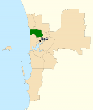
The City of Stirling is a local government area in the northern suburbs of the Western Australian capital city of Perth about 10 kilometres (6 mi) north of Perth's central business district. The City covers an area of 105.2 square kilometres (40.6 sq mi) and has a population of over 223,000, making it the largest local government area by population in Western Australia.

Doubleview is a suburb of Perth, Western Australia in the local government area of the City of Stirling. It was named Doubleview due to its views of both the Indian Ocean to the west and the Darling Range to the east.
Carine is a suburb of Perth, the capital city of Western Australia, and is located 14 kilometres (9 mi) north of Perth's central business district (CBD) between Marmion Avenue and Mitchell Freeway. Its local government area is the City of Stirling.

Gwelup is a suburb of Perth, the capital city of Western Australia 12 km north of Perth's central business district (CBD) along the Mitchell Freeway. Its local government area is the City of Stirling.

Hamersley is a residential suburb 14 kilometres north-northwest of the central business district of Perth, the capital of Western Australia, and six kilometres (4 mi) from the Indian Ocean. The suburb adjoins two major arterial roads—Mitchell Freeway to the west and Reid Highway to the south—and is within the City of Stirling local government area. It was built during the late 1960s and 1970s as part of the Government of Western Australia's response to rapidly increasing land prices across the metropolitan area.

Inglewood is an inner-city suburb of Perth, Western Australia, 4 kilometres (2 mi) north-east of its central business district. It is located within the local government area of the City of Stirling.

North Beach is a northern coastal suburb of Perth, the capital city of Western Australia 16 kilometres (10 mi) from Perth's central business district via Mitchell Freeway and Reid Highway. Its local government area is the City of Stirling.
The Division of Stirling was an Australian electoral division in the inner northern and beachside suburbs of Perth, Western Australia, which included a large portion of the local government area of the City of Stirling.

The Division of Perth is an Australian electoral division in the state of Western Australia. It is named after Perth, the capital city of Western Australia, where the Division is located.

Watermans Bay is a northern coastal suburb of Perth, the capital city of Western Australia. Its local government area is the City of Stirling.

Baldivis is a semi-rural residential suburb 46 kilometres (29 mi) south of Perth, Western Australia, and 11 kilometres (6.8 mi) southeast of the regional centre of Rockingham. It is located within the City of Rockingham local government area.
Wembley is a western suburb of Perth, Western Australia, located within the Town of Cambridge. Its postcode is 6014.
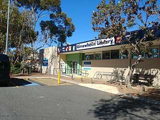
Girrawheen is a northern suburb of Perth, the capital city of Western Australia. Its local government area is the City of Wanneroo.

Wanneroo Road is a 44-kilometre (27 mi) arterial highway in the northern suburbs of Perth, Western Australia linking Joondanna and Yokine in the south with Wanneroo and Yanchep in the north. As part of State Route 60, it begins from Charles Street in the inner city and becomes Indian Ocean Drive up to Dongara.
Balcatta is an electoral district of the Legislative Assembly in the Australian state of Western Australia.

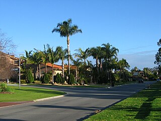
Stirling is a suburb of Perth, the capital city of Western Australia, about 10 km north of Perth's central business district (CBD) along the Mitchell Freeway. Its local government area is the City of Stirling, whose council offices and administration centre are located in the southwest of the mostly residential suburb.
Collingwood Heights is a north-eastern suburb of Albany, Western Australia, between the Albany city centre and Emu Point within the local government area of the City of Albany.

Alexander Drive is a major north–south arterial road in the northern suburbs of Perth, Western Australia, connecting Perth's central business district (CBD) with Edith Cowan University's Mount Lawley campus and the Malaga industrial area, as well as newer development suburbs to Perth's north. It is used by Transperth bus routes, including the 360, 361 and 362. Alexander Drive was named after Mr S.B. Alexander, a former Wanneroo Road Board member. Alexander Drive runs through the following local government areas City of Wanneroo, City of Swan, City of Bayswater and City of Stirling.

Morley Drive is a major east–west road in the inner northern suburbs of Perth, Western Australia, connecting the residential areas of Balcatta, Osborne Park, Tuart Hill, Nollamara, Yokine, Dianella, and Morley with major north-south arterial roads including Wanneroo Road, Alexander Drive, and Tonkin Highway.

St Denis Church is a Roman Catholic church in the Perth suburb of Joondanna, Western Australia.


