
Central Sulawesi is a province of Indonesia located at the centre of the island of Sulawesi. The administrative capital and largest city is located in Palu. The 2010 census recorded a population of 2,635,009 for the province, and the 2015 Census of 2,876,689, while the latest official estimate is 3,042,100. Central Sulawesi has an area of 61,841.29 km2 (23,877 sq mi), the largest area among all provinces on Sulawesi Island, and has the second-largest population on Sulawesi Island after the province of South Sulawesi. It is bordered by the provinces of Gorontalo to the north, West Sulawesi, South Sulawesi and South East Sulawesi to the south, by Maluku to the east, and by the Makassar Strait to the west. The province is inhabited by many ethnic groups, such as the Kaili, Tolitoli, etc. The official language of the province is Indonesian, which is used for official purposes and inter-ethnic communication, while there are several indigenous language spoken by the Indigenous peoples of Central Sulawesi. Islam is the dominant religion in the province, followed by Christianity which are mostly adhered by the people in the eastern part of the province.

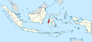
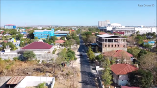
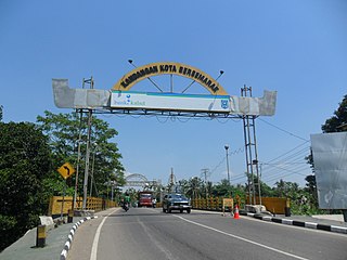
Poso is the administrative capital of Poso Regency, Indonesia. It is the main port and transportation hub for the central-southern coast of Central Sulawesi. Its urban area consists of three districts, Poso Kota, North Poso Kota, and South Poso Kota. Poso lies in the middle of the province on the shore of the Gulf of Tomini, right in the central part of Sulawesi island. With a total population of 47,477 in 2020, it is one of the biggest and the oldest towns in the province.
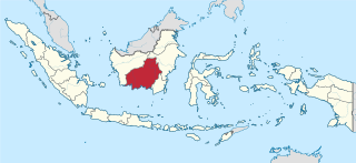
Central Kalimantan, is a province of Indonesia. It is one of five provinces in Kalimantan, the Indonesian part of Borneo. Its provincial capital is Palangkaraya and in 2010 its population was over 2.2 million, while the 2015 showed a rise to 2.49 million and the latest official estimate is 2,649,803.

East Nusa Tenggara is the southernmost province of Indonesia. It comprises the eastern portion of the Lesser Sunda Islands, facing the Indian Ocean in the south and the Flores Sea in the north. It consists of more than 500 islands, with the largest ones being Sumba, Flores, and the western part of Timor; the latter shares a land border with the separate nation of East Timor. The province is subdivided into twenty-one regencies and the regency-level city of Kupang, which is the capital and largest city.
West Sulawesi is a province of Indonesia. It is located in the western of the Sulawesi island. It covers an area of 16,937.16 km2, and its capital is Mamuju. The 2010 Census recorded a population of 1,158,651, while that in 2015 recorded 1,279,994; the latest official estimate is 1,536,115.
Kupang is the capital of the Indonesian province of East Nusa Tenggara. In 2020, its estimated population was 442,758. It is the biggest city and port on the island of Timor. Kupang is a part of the Timor Leste-Indonesia-Australia Growth Triangle free trade zone.
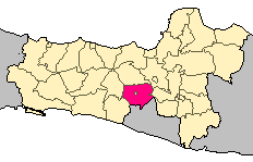
Magelang is a regency in Central Java, Indonesia, famous for its 9th century Buddhist temple of Borobudur. Its capital is Mungkid. It covers an area of 1,085.73 km2 and had a population of 1,181,723 at the 2010 Census and 1,299,859 at the 2020 Census. These figures exclude the autonomous city of Magelang, which is separately administered but is geographically enclaved within the regency, which borders Temanggung Regency to the north, Semarang Regency to the northeast, Boyolali Regency to the east, the Special Region of Yogyakarta to the south and southeast, Purworejo Regency to the southwest, and Wonosobo Regency to the west. Its motto is Magelang Gemilang.

Indramayu is a town and district which serves as the capital of Indramayu Regency in the West Java province of Indonesia, and is located in the northern coastal area of West Java, east from Jakarta, north-east from the city of Bandung, and north-west of the city of Cirebon. Most of its land are situated below sea level, which makes the district vulnerable to high tide in stormy conditions. The district is only protected by some dunes and barrages at the seaside.

Lhokseumawe, is the second largest city in Aceh Special District, in the north of Sumatra, Indonesia. The city covers an area of 181.06 square kilometres, and had a population of 171,163 at the 2010 Census and 188,713 at the 2020 Census. Being between Banda Aceh and the large southern city of Medan, the town is a key regional centre important for the economy of Aceh.
Kandangan is a district and the regency seat of South Hulu Sungai Regency in South Kalimantan province. The district has an area of 106.71 square kilometers. According to 2019 estimates, the population of the district was 51,847 people spread across 18 subdistricts.

Bontang is a city on the eastern coast of the island of Borneo in Indonesia, in the province of East Kalimantan. It occupies an area of 497.57 km2 (192.11 sq mi), and the population was 140,787 at the 2010 Census, and 178,917 as of 2020. It is also the third most densely populated place in the province after Balikpapan and Samarinda.

Demak is a regency located in the Indonesian province of Central Java, on northern coast of the island. It is bordered by Jepara regency and the Java Sea to the north, Kudus and Grobogan regencies to the east, Grobogan and Semarang regencies to the south, while to the west are Semarang Regency and the city of Semarang, to which the districts of Mranggen and Sayung are essentially suburban. The regency covers an area of 897.43 km2 and had a population of 1,055,579 at the 2010 Census; the latest official estimate is 1,162,805. It was originally the centre of the Demak Sultanate, once a dominant power in the region. Due to its strong relation with the spread of Islam in Java and the Wali Sanga, it is sometimes referred to with the nickname Kota Wali.

Kisaran is a city in the North Sumatra province of Indonesia. Kisaran is the administrative capital of Asahan Regency. Kisaran is divided into two administrative districts (kecamatan) - West Kisaran District and East Kisaran District. Kisaran is situated on the Trans-Sumatra Highway, and is also located in the path of trains of northern Sumatra.

Malinau Regency is a regency of North Kalimantan Province in Indonesia. The administrative centre is the town of Malinau. The regency is home to the Kayan Mentarang National Park. It covers an area of 39,799.90 km2, and had a population of 62,423 at the 2010 Census; the 82,510 at the 2020 Census. It is regency with the largest area in the province, as well as the least densely populated. Other than that, Malinau is the only regency in North Kalimantan that is predominantly Protestant and the second most-developed region in North Kalimantan after Tarakan in terms of Human Development Index.

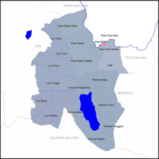
Poso Regency is a regency of Central Sulawesi Province of Indonesia. It covers an area of 7,112.25 km2, and had a population of 209,228 at the 2010 Census and 244,875 at the 2020 Census. The principal town lies at Poso.

Tual is a city in Maluku Province of Indonesia. The city, called Kota Tual in Indonesian, is within the Kei Islands, on Dullah Island, but since 2007 has been administratively separate from the rest of the Kei Islands, which form the Southeast Maluku Regency and comprise two principal islands together with over 190 smaller offshore islands.
Poso Kota is a district in Indonesia. It is located in the Poso Regency of Central Sulawesi. Along with the neighboring districts of North and South Poso Kota, this district makes up the capital region of Poso Regency, Poso, covering 56.57 km2 with a population of 47,477 in 2020.

South Poso Kota is a district in Indonesia. It is located in the Poso Regency of Central Sulawesi. Along with the neighboring districts of Poso Kota and North Poso Kota, this district makes up the capital region of Poso Regency, Poso, covering 56.57 km2 with a population of 47,477 in 2020.
Sawang is a subdistrict located in North Aceh Regency, Aceh Province, Indonesia.
