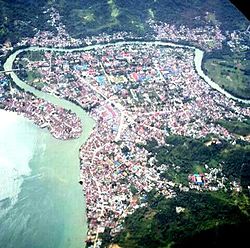
Poso

Last updated
Poso
Kota Poso (2015).jpg
Poso in 2015
Poso Sentinel-2 L2A, True Color on December 5, 2020.png
Sentinel-2 L2A satellite image, featuring the city of Poso in December 2020
Sulawesi location map plain.svg
Red pog.svg
Poso
Location of Poso in Sulawesi
Coordinates: 1°24′S120°45′E / 1.400°S 120.750°E / -1.400; 120.750
Country Flag of Indonesia.svg  Indonesia
Province Central Sulawesi
Regency Poso
Area
  Total56.57 km2 (21.84 sq mi)
Population
 (2020 Census)
  Total47,477
  [1]
Time zone UTC+8 (Central Indonesia Time)
Website http://posokab.go.id/

Poso (Old Spelling: Posso) is the administrative capital of Poso Regency, Indonesia. It is the main port and transportation hub for the central-southern coast of Central Sulawesi. Its urban area consists of three districts, Poso Kota, North Poso Kota, and South Poso Kota. Poso lies in the middle of the province on the shore of the Gulf of Tomini, right in the central part of Sulawesi Island. With a total population of 47,477 in 2020, it is one of the biggest and oldest towns in the province. [2]

Contents

Poso began to develop as a small port town located at the mouth of the Poso River at the end of the 19th century—making it one of the oldest towns in Central Sulawesi, its presence was considered important for the Dutch to control the southern region of Tomini in the early days of their arrival. Poso was the administrative center of Landschap Poso, Onderafdeling Poso, and later Afdeling Poso during colonial times. Amid World War II, the Japanese made Poso one of their military posts. Post-independence, Poso was chosen as the capital of the newly formed Central Sulawesi in 1948 before the capital was moved to Palu in 1951.

The central location of Poso has made it a stopover either from the north to the south, or from west to the east of Sulawesi. It is for this reason that the population of Poso consists of many different ethnicities, religions, and backgrounds. People living in Poso are spread from the coastal area to the mountainous region, with the main sources of income being trade and services.

Poso is crossed by the Trans-Sulawesi National Highway and served by Kasiguncu Airport, linking it to other cities in Sulawesi such as Palu and Makassar.

Geography

Climate

Poso has a tropical rainforest climate (Af) with heavy rainfall year-round.

Climate data for Poso
MonthJanFebMarAprMayJunJulAugSepOctNovDecYear
Mean daily maximum °C (°F)30.6
(87.1)
30.7
(87.3)
30.9
(87.6)
31.0
(87.8)
31.1
(88.0)
30.3
(86.5)
29.7
(85.5)
30.8
(87.4)
31.2
(88.2)
32.2
(90.0)
31.8
(89.2)
31.1
(88.0)
31.0
(87.7)
Daily mean °C (°F)26.8
(80.2)
26.8
(80.2)
27.0
(80.6)
27.0
(80.6)
27.4
(81.3)
26.6
(79.9)
25.9
(78.6)
26.6
(79.9)
26.7
(80.1)
27.5
(81.5)
27.5
(81.5)
27.1
(80.8)
26.9
(80.4)
Mean daily minimum °C (°F)23.0
(73.4)
23.0
(73.4)
23.1
(73.6)
23.1
(73.6)
23.7
(74.7)
23.0
(73.4)
22.2
(72.0)
22.5
(72.5)
22.3
(72.1)
22.9
(73.2)
23.2
(73.8)
23.2
(73.8)
22.9
(73.3)
Average rainfall mm (inches)162
(6.4)
157
(6.2)
247
(9.7)
291
(11.5)
253
(10.0)
256
(10.1)
219
(8.6)
193
(7.6)
201
(7.9)
144
(5.7)
197
(7.8)
197
(7.8)
2,517
(99.3)
Source: Climate-Data.org [3]

Tourism and culture

Poso can be reached by plane from Palu or by bus from many other big cities on Sulawesi and is situated on the equator. It features tropical rain forest, seashore gardens, and other natural scenery. Sintuwu Maroso Square is the main town square and is located in central Poso. Rumah Katu Marine Park is a water park located 10 km from the center of Poso.

Modero is a well-known traditional dance that is performed during the celebration of rice harvesting (Padungku), usually in the evenings.

See also

Related Research Articles

<span class="mw-page-title-main">Central Sulawesi</span> Province of Indonesia

Central Sulawesi is a province of Indonesia located at the centre of the island of Sulawesi. The administrative capital and largest city is located in Palu. The province borders the provinces of Gorontalo to the east, Southeast Sulawesi, South Sulawesi, and West Sulawesi to the south, and sharing maritime borders with East Kalimantan to the west, North Maluku to the east, and Malaysia and the Philippines to the north. The 2010 census recorded a population of 2,635,009 for the province, and the 2020 Census recorded 2,985,734, of whom 1,534,706 were male and 1,451,028 were female. The official estimate as at mid 2022 was 3,066,143. Central Sulawesi has an area of 61,605.72 km2 (23,786 sq mi), the largest area among all provinces on Sulawesi Island, and has the second-largest population on Sulawesi Island after the province of South Sulawesi. It is bordered by the provinces of Gorontalo to the north, West Sulawesi, South Sulawesi and South East Sulawesi to the south, by Maluku to the east, and by the Makassar Strait to the west. The province is inhabited by many ethnic groups, such as the Kaili, Tolitoli, etc. The official language of the province is Indonesian, which is used for official purposes and inter-ethnic communication, while there are several indigenous language spoken by the Indigenous peoples of Central Sulawesi. Islam is the dominant religion in the province, followed by Christianity which is mostly adhered to by the people in the eastern part of the province.

<span class="mw-page-title-main">Palu</span> Capital and largest city of Central Sulawesi, Indonesia

Palu, officially known as the City of Palu, is the capital and largest city of Central Sulawesi. Palu is located on the northwestern coast of Sulawesi and borders Donggala Regency to the north and west, Parigi Moutong Regency to the east, and Sigi Regency to the south. The city boundaries encompass a land area of 395.06 km2 (152.53 sq mi). According to the 2020 Indonesian census, Palu had a population of 373,218, making it the third-most populous city on the island after Makassar and Manado; the official estimate as at mid 2022 was 381,572 - comprising 191,052 males and 190,520 females. Palu is the center of finance, government, and education in Central Sulawesi, as well as one of several major cities on the island. The city hosts the province's main port, its biggest airport, and most of its public universities.

<span class="mw-page-title-main">Gorontalo (city)</span> City and capital of Gorontalo, Indonesia

Gorontalo is a city and the capital of the Gorontalo Province, Sulawesi, Indonesia. The city has an area of 79.59 km2 and had a population of 179,991 at the 2010 census and 198,539 at the 2020 census; the official estimate as at mid 2022 was 201,350. Previously part of North Sulawesi, it became the capital of the newly-formed Gorontalo Province on 5 December 2000. As the largest settlement and the only city in the province, it is the economic, political, and educational center of the province, hosting most of its universities and is the location of one of the only two public university in the province. The city is also cultural center of the Gorontalo people and have been under various small kingdoms and later the Islamic Gorontalo Kingdom, among others before being incorporated under Dutch East Indies as Afdeling Gorontalo and then later kotapraja under the Indonesian Republic. Due to relatively religious culture of the Gorontaloan people and its history with Islam, the city is sometimes referred to as "Porch of Medina".

<span class="mw-page-title-main">Poso Regency</span> Regency in Central Sulawesi, Indonesia

Poso Regency is a regency of Central Sulawesi Province of Indonesia. It covers an area of 7,112.25 km2, and had a population of 209,228 at the 2010 Census and 244,875 at the 2020 Census; the official estimate as at mid 2022 was 252,650. The principal town lies at Poso.

<span class="mw-page-title-main">Sigi Regency</span> Regency in Central Sulawesi, Indonesia

Sigi Regency is a regency of Central Sulawesi, Indonesia. It lies upstream on the Palu River, and immediately south of Palu city, the provincial capital. It covers an area of 5,196.02 km2 and had a population of 215,030 at the 2010 Census and 239,421 at the 2020 Census; the official estimate as at mid 2022 was 266,812. The principal town lies at Sigi Biromaru.

<span class="mw-page-title-main">Pamona people</span> Ethnic group of Indonesia

The Pamona people is an ethnic group of Indonesia. They inhabit almost the entire Poso Regency, parts of Tojo Una-Una Regency and parts of North Morowali Regency, Central Sulawesi; in fact there are some even in East Luwu Regency of South Sulawesi, whereas a small remainder lives in other parts of Indonesia. The ancestors of the Pamona people originally came from the land of Salu Moge because they were once from the mountains which is far from the central governance thus they were brought down by Macoa Bawalipu of Wotu, East Luwu Regency to be nearer to the central governance, which is the surrounding region of Mangkutana. But it was until a revolt by the DI/TII rebellion broke out that they spread to Central Sulawesi and to other regions. If there are Pamona people in certain regions, then it is common that a Rukun Poso is formed there, which serves as a means of a group of people from a common ethnic background to engage in various activities within the region. Almost all of the Pamona people practices Christianity. Christianity came into the region at the end of the 19 century and until today it is widely accepted as the religion of the people. Today, all churches of common denomination are grouped under the Central Sulawesi Christian Church headquartered in Tentena, Poso Regency, Central Sulawesi, Indonesia. A large part of the common folk uses Pamona and Indonesian language that is mixed with the local slang. The Pamona people are usually farmers, government officials, pastors, entrepreneurs and so on.

<span class="mw-page-title-main">Poso riots</span> Religious conflicts in Indonesia

The Poso riots, also known as Poso communal conflict, is a name given to a series of riots that occurred in Poso, Central Sulawesi, Indonesia. This incident involved a group of Muslims and Christians in the region and was divided into three stages. The first Poso riot took place from December 25 to 29, 1998, continued from April 17 to 21, 2000, and finally from May 16 to June 15, 2000.

<span class="mw-page-title-main">Islam in Central Sulawesi</span>

Islam in Central Sulawesi, a province of Indonesia, is the majority religion embraced by around 75% of the province's 2,683,722 inhabitants . The propagators of Islam were thought to enter Central Sulawesi through neighboring regions, namely Bone, Wajo, and Mandar from the south and west routes, and through Gorontalo and Ternate from the north and east routes via Tomini Bay and Tolo Bay.

<span class="mw-page-title-main">Bungku people</span>

Bungku people are an ethnic group who mostly resides in North Bungku, South Bungku, Central Bungku, and Menui Islands districts di Morowali Regency, in Central Sulawesi province of Indonesia. This ethnic group is divided into several sub-groups, namely Lambatu, Epe, Ro'tua, Reta, and Wowoni. Bungku people have their own language, called Bungku language, which is one of their characteristic and serves as a means of communication between themselves. They generally embrace Islam or Christianity.

<span class="mw-page-title-main">2018 Sulawesi earthquake and tsunami</span> 7.5 Mw earthquake Landslide and tsunami in Indonesia

On 28 September 2018, a shallow, large earthquake struck in the neck of the Minahasa Peninsula, Indonesia, with its epicentre located in the mountainous Donggala Regency, Central Sulawesi. The magnitude 7.5 quake was located 70 km (43 mi) away from the provincial capital Palu and was felt as far away as Samarinda on East Kalimantan and also in Tawau, Malaysia. This event was preceded by a sequence of foreshocks, the largest of which was a magnitude 6.1 tremor that occurred earlier that day.

<span class="mw-page-title-main">Alkhairaat</span>

Alkhairaat is the largest Islamic community organization in eastern Indonesia based in Palu, Central Sulawesi. This organization was founded by an Arab Indonesians cleric who born in Hadhramaut named Habib Sayyid Idrus bin Salim al-Jufri on June 30, 1930.

This is a list of emblems or coat of arms used in Indonesia. Indonesia is divided into 38 provinces, and each province is divided into regencies (kabupaten) and cities (kota). There are 416 regencies and 98 cities. Each province, regency, and city has its own emblem.

In Indonesian law, the term "city" is generally defined as the second-level administrative subdivision of the Republic of Indonesia, an equivalent to regency. The difference between a city and a regency is that a city has non-agricultural economic activities and a dense urban population, while a regency comprises predominantly rural areas and is larger in area than a city. However, Indonesia historically had several classifications of cities.

<span class="mw-page-title-main">Rusdy Mastura</span> Indonesian politician

Rusdy Mastura is an Indonesian politician who is the governor of Central Sulawesi and was the mayor of the province's capital, Palu, between 2005 and 2015.

<span class="mw-page-title-main">Ihwan Datu Adam</span> Indonesian politician (1964–2021)

Ihwan Datu Adam was an Indonesian politician who became the Vice Regent of North Penajam Paser from 2003 until 2007, member of the Regional People's Representative Council of East Kalimantan from 2009 until 2012, and as the member of the People's Representative Council from 2017 until 2019.

<span class="mw-page-title-main">Bandjela Paliudju</span> Indonesian politician (born 1945)

Bandjela Paliudju is an Indonesian military officer and politician who served as the governor of Central Sulawesi from 1996 until 2001 and 2006 until 2011.

The 2021 Liga 3 Central Sulawesi will be the sixth season of Liga 3 Central Sulawesi as a qualifying round for the national round of the 2021–22 Liga 3.

<span class="mw-page-title-main">Sulawesi Canal</span> Proposed canal located on the island of Sulawesi, Indonesia

The Sulawesi Canal, also known as Equatorial Canal, refers to proposals for a canal on the island of Sulawesi, connecting the Gulf of Tomini with the Makassar Strait, with the aim of becoming a busy international sea route that will shorten the sea transport distance from the eastern part of Sulawesi Island to the western part of Indonesia, as well as to the Philippines and Malaysia.

References

  1. Badam Pusat Statistik, Jakarta, 2021.
  2. "Selayang Pandang Kota Poso". Pemerintah Kabupaten Poso (in Indonesian). February 8, 2016. Archived from the original on January 8, 2017. Retrieved January 14, 2017.
  3. "Climate: Poso". Climate-Data.org. Retrieved 21 November 2020.

Sources

Books

Journals

Reports

Websites