
North Somerset is a unitary authority in the ceremonial county of Somerset, England. The council is based in Weston-super-Mare, the area's largest town. The district also contains the towns of Clevedon, Nailsea and Portishead, along with a number of villages and surrounding rural areas. Some southern parts of the district fall within the Mendip Hills, a designated Area of Outstanding Natural Beauty.

Nailsea is a town in North Somerset, England, 8 miles (13 km) southwest of Bristol, and 11 miles (18 km) northeast of Weston-super-Mare. The nearest village is Backwell, which lies south of Nailsea on the opposite side of the Bristol to Exeter railway line. Nailsea had a population of 15,630 in the 2011 Census.
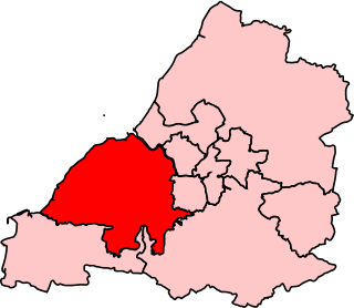
Woodspring was a constituency represented in the House of Commons of the Parliament of the United Kingdom from 1983 until 2010. It elected one Member of Parliament (MP) by the first past the post system of election. From 1992 until 2010, it was represented by Liam Fox, former Secretary of State for Defence. Fox went on to represent the new North Somerset constituency from 2010.

Tickenham is a village and civil parish near Clevedon and Nailsea in North Somerset, England. The parish has a population of 910. It has a primary school, a village hall and a garden centre, but no shops, although it formerly had a post office.

North Somerset is a constituency represented in the House of Commons of the UK Parliament since 2010 by Liam Fox, a Conservative who served as Secretary of State for International Trade, a new position in the Cabinet, from 2016 to 2019.

Yatton railway station, on the Bristol to Exeter line, is in the village of Yatton in North Somerset, England. It is 12 miles (19 km) west of Bristol Temple Meads railway station, and 130 miles (209 km) from London Paddington. Its three-letter station code is YAT. It was opened in 1841 by the Bristol and Exeter Railway, and served as a junction station for trains to Clevedon and Cheddar, but these lines closed in the 1960s. The station, which has two platforms, is managed by Great Western Railway, the seventh company to be responsible for the station, and the third franchise since privatisation in 1997. They provide all train services at the station, mainly hourly services between Bristol Parkway and Weston-super-Mare, and between Cardiff Central and Taunton.

Nailsea and Backwell railway station, on the Bristol to Exeter line, is in the village of Backwell, close to the town of Nailsea in North Somerset, England. It is 8 miles (13 km) west of Bristol Temple Meads railway station, and 126 miles (203 km) from London Paddington. The station, opened in 1841 by the Bristol and Exeter Railway, has two platforms but little in the way of facilities. It is managed by Great Western Railway, the seventh company to be responsible for the station, and the third franchise since privatisation in 1997. The company provides all train services at the station, mainly hourly services between Bristol Parkway and Weston-super-Mare, and between Cardiff Central and Taunton.

Biddle Street, Yatton is a 44.8 hectare biological Site of Special Scientific Interest (SSSI) near the village of Yatton in North Somerset, notified in 1994.

Tickenham, Nailsea and Kenn Moors SSSI is a 129.4 hectare biological Site of Special Scientific Interest between Tickenham, Nailsea and Kenn on the North Somerset Levels, notified in 1995.

Puxton Moor is a 31.07 ha biological Site of Special Scientific Interest on the North Somerset Levels, near Puxton, North Somerset, notified in 1994. It is a large area of pasture land networked with species-rich rhynes, now owned and managed as a nature reserve by Avon Wildlife Trust.

Max Bog is a 10.6 hectare biological Site of Special Scientific Interest in North Somerset, notified in 1988.
Somerset Premier is an English rugby union league which sits at the eighth level of league rugby union in England involving teams based in the county of Somerset as well as some teams based in Bristol. Originally a single division called Gloucestershire/Somerset, in 2000 the division split into two county leagues called Gloucester Premier and Somerset Premier.
Long Ashton was a rural district in Somerset, England, from 1894 to 1974.
There are several nature reserves in the surroundings of Nailsea, North Somerset, England, which is located at 51°25′55″N2°45′49″W.

The Land Yeo is a small river which flows through North Somerset, England. It rises on Dundry Hill and supplies Barrow Gurney Reservoirs before flowing through various villages to Clevedon where it drains into the Severn Estuary. During the past 1,000 years it has powered at least ten watermills, however only one is still functional. Since 2003 initiatives have been undertaken to clean up the river, improving water quality and encouraging wildlife.

The Somerset County Rugby Football Union (SCRFU) is the governing body for the sport of rugby union in the county of Somerset in England. The union is the constituent body of the Rugby Football Union (RFU) for Somerset. The SCRFU administers and organises rugby union clubs and competitions in the Somerset including the county rugby representative teams.

