Avonmouth

Last updated

Avonmouth
Avonmouth St Andrew.JPG
Bristol UK location map.svg
Red pog.svg
Avonmouth
Location within Bristol
Population3,402  2011 Census - Avonmouth equates to output areas Bristol 008E and 008F
OS grid reference ST516785
  London 110 miles (180 km)
Unitary authority
Ceremonial county
Region
Country England
Sovereign state United Kingdom
Post town BRISTOL
Postcode district BS11
Dialling code 0117
Police Avon and Somerset
Fire Avon
Ambulance South Western
UK Parliament
List of places
UK
England
Bristol
51°30′04″N2°41′56″W / 51.501°N 2.699°W / 51.501; -2.699

Avonmouth is a port and outer suburb of Bristol, England, facing two rivers: the reinforced north bank of the final stage of the Avon which rises at sources in Wiltshire, Gloucestershire and Somerset; and the eastern shore of the Severn Estuary. Strategically the area has been and remains an important part of the region's maritime economy particularly for larger vessels for the unloading and exporting of heavier goods as well as in industry including warehousing, light industry, electrical power and sanitation. The area contains a junction of and is connected to the south by the M5 motorway and other roads, railway tracks and paths to the north, south-east and east.

Contents

The council ward of Avonmouth and Lawrence Weston is as drawn a simplified name as it includes Shirehampton and the western end of Lawrence Weston. [n 1]

Geography

The River Avon with Avonmouth and the M5 bridge 040424 026 avonmouth.jpg
The River Avon with Avonmouth and the M5 bridge

Avonmouth is approximately rectangular, its length favouring the Severn shore and sits on the same bank as the city centre from which it lies west-north-west – at the mouth of the River Avon and on the eastern shore of the dredged, at this point highly saline Severn Estuary. Both rivers in shallow valleys by this stage have been defensively embanked primarily to allow the construction of the large port Avonmouth Docks which occupies most of the western part. The related Royal Portbury Dock is across the Avon (in Easton-in-Gordano). Avonmouth is home to chemical manufacturing plants, [1] [2] and north of the Avonmouth Docks is the gas-fired Seabank Power Station. [3] Its light industrial and warehouse companies include Nisbets.

Its long-established residential area in Avonmouth is between the industrialised zone and the M5 motorway, uniquely for Bristol west of the M5 motorway. Avonmouth Bridge of the M5 motorway forms the connection with Somerset, specifically with Easton-in-Gordano. The Wales-connecting M49 motorway runs between the M5 near Avonmouth and the M4 motorway at the Second Severn Crossing. The old Severn Bridge and the M48 motorway are linked to Avonmouth by the A403. The Welsh cities of Newport and Cardiff are both clearly visible from Avonmouth's coastline.

The Portway, part of the A4, connects Avonmouth with the centre of Bristol. Avonmouth is also served by a usually hourly train service to central Bristol from Avonmouth railway station on the Severn Beach Line.

A new deep-sea container terminal is planned for Avonmouth. [4]

History

The mouth of the Avon was recorded as Afenemuþan in the Anglo-Saxon Chronicle under the years 915 or 918 and 1052, [5] but it is clear from the context that the name does not refer to a settlement. [6] :16 The area was historically part of the chapelry of Shirehampton, a detached part of the ancient parish of Westbury-on-Trym in Gloucestershire. [7] Bewys Cross, a stone monument possibly dating from the 15th century, was located on the bank of the Severn close to the old mouth of the Avon. Early 19th-century maps show the area as farmland. At that time the deep water channel of the Avon ran through the present-day site of Avonmouth Docks and separated the mainland from a small island named Dumball Island. [6] :8

The first development at Avonmouth was a landing stage built in 1860 by Bristol Corporation at "Avon's Mouth". The first record of the modern name was in the title of the Port and Channel Docks (Avonmouth Dock) Bill debated in Parliament in early 1863. [6] :15 When the Bristol Port Railway and Pier was built in 1865 the terminus station was named Avonmouth. A hotel, the Avonmouth Hotel, was opened at the same time. A small new village was built to serve the new docks, which were finally opened in 1877. Also in 1877, the BPRP line was connected to the main railway network by the Clifton Extension Railway, and a new railway station named Avonmouth Dock was opened by the docks. Bricks for the docks were supplied by the Crown Brick Works in West Town, Shirehampton, [8] [9] visible on the 1879 Ordnance Survey map. [10] The Crown Brick Works were owned by Edwin Stride, with his sons Jared and Jethro (who later developed Sneyd Park), together with George Davis and William and Jarman Peters. [11] The Crown Brick Works company was dissolved in 1886 [12]

The new Avonmouth Dock and the original nucleus of the settlement were transferred from Gloucestershire to the City of Bristol in 1894, and the rest of the expanding settlement became part of the City in 1904. [6] :7

Avonmouth station Avonmouth railway station MMB 03.jpg
Avonmouth station

In 1902 work began on the Royal Edward Dock, a major expansion of the docks, completed in 1908. Land required for the expansion necessitated the closure of the original station, and from 1902 all trains terminated at Avonmouth Dock station (renamed "Avonmouth" in 1966). However, the Avonmouth Hotel adjacent to the original station remained open. It provided accommodation for many Europeans emigrating to the Americas via Avonmouth, and during the First World War it housed the Women's Army Auxiliary Corps. It was finally demolished in 1926 when the Royal Edward Dock was expanded. [13]

Between 1919 and 1926, the Portway was built, providing more direct road access to Avonmouth from Bristol.

Shirehampton had become a separate parish in 1844, and a Church of England chapel was established in the new settlement of Avonmouth late in the nineteenth century. Avonmouth became a separate parish in 1917. [6] :7 Avonmouth's first church, completed in 1934, was bombed in World War II by the Luftwaffe in one of the six major raids of the Bristol Blitz, in 1941. It was later rebuilt in 1957. [14]

In December 1971, the M5 motorway was opened to Avonmouth, and extended south into Somerset when the Avonmouth Bridge was opened in May 1974. [15]

On 3 December 2020, four people were killed in an explosion at the water treatment plant. [16] [17]

Local places of interest

Avonmouth Sewage Works Nature Reserve

The 10-hectare (25-acre) Avonmouth Sewage Treatment Works is managed as a nature reserve by Wessex Water. The human-made lagoons and a pool provide a feeding and resting area for many birds including ducks such as pochard, tufted duck, teal and shoveler. The rough grassland provides a refuge for voles, great crested newt and other small mammals, [18] which are preyed upon by kestrels and barn owls. [19] [20]

The Range Distribution Centre

Avonmouth is home to the largest single footprint warehouse in the United Kingdom, [21] a 1,250,000 sq ft portal frame building operated by The Range as a distribution centre. The enormous building occupies 55 acres of land [22] and is part of the Central Park project located close to the Severn estuary shoreline. Previously, the largest single footprint warehouse in the United Kingdom was a building operated by Amazon in Dunfermline, Scotland which covers 1,000,000 sq ft.

Governance

Avonmouth is part of the Bristol North West constituency, which elects a member of Parliament (MP).

As a ward of Bristol City Council which has local elections in three of every four years, Avonmouth and Lawrence Weston June 2016 to May 2018 three councillors:

Apart from Avonmouth itself, the ward includes Shirehampton and part of Lawrence Weston. Shirehampton is a part of Bristol which has a medieval-founded village nucleus and contains buildings dating more than a century earlier than the earliest examples in Avonmouth. Today the pre-1893 mother parish of Shirehampton has definitive boundaries and c. 6,867 inhabitants. [24] [25] Shirehampton railway station provides travel to the city centre. The western end of the Lawrence Weston area crosses the boundary into the Avonmouth ward, however the majority of the area falls within the Kingsweston ward. The combined area is separated from the rest of Bristol by a small amount of green land, see buffer zones.

Notes

  1. Wards are periodically redrawn on arithmetical grounds to avoid malapportionment which arises from adult population change increasing or decreasing electors per councillor

Related Research Articles

<span class="mw-page-title-main">River Avon, Bristol</span> River in the south west of England

The River Avon is a river in the southwest of England. To distinguish it from a number of other rivers of the same name, it is often called the Bristol Avon. The name 'Avon' is a cognate of the Welsh word afon, meaning 'river'.

<span class="mw-page-title-main">Portishead, Somerset</span> Town in Somerset, England

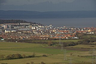
Portishead is a town and civil parish in the North Somerset unitary authority area, in the county of Somerset, England. The town has a population of 27,000 and is located next to the Severn Estuary opposite Cardiff and Newport in Wales. The town is 8 miles (13 km) to the west of Bristol and 18 miles northeast of Weston-super-Mare.

<span class="mw-page-title-main">Severn Beach</span> Human settlement in England

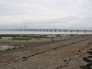
Severn Beach is a village on the Severn Estuary in South Gloucestershire, England. The eastern portal of the Severn Tunnel is on the outskirts of the village. The Severn footpath – on the sea wall – is part of the Severn Way that leads from Gloucester, Slimbridge and the Second Severn Crossing. Extensive sea defences have been constructed and this provides a popular walkway along its length. Originally, the Severn Way finished at Severn Beach, but it has been extended to Bristol.

<span class="mw-page-title-main">Severn Beach line</span> Railway in Bristol and Gloucestershire, England

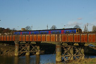
The Severn Beach line is a local railway line in Bristol and Gloucestershire, England, which runs from Bristol Temple Meads to Severn Beach, and used to extend to Pilning. The first sections of the line were opened in 1863 as part of the Bristol Port Railway and Pier; the section through Bristol was opened in 1875 as the Clifton Extension Railway.

<span class="mw-page-title-main">Shirehampton</span> Human settlement in England

Shirehampton is a district of Bristol in England, near Avonmouth, at the northwestern edge of the city.

<span class="mw-page-title-main">Easton in Gordano</span> Village in Somerset, England

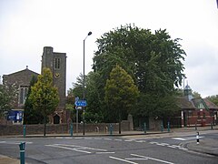
Easton in Gordano is a village in Somerset, England, about 4+12 miles (7 km) northwest of Bristol city centre. It is part of the civil parish of Pill and Easton-in-Gordano and within the unitary authority of North Somerset. In 2011 the population of the parish was 4,828.

<span class="mw-page-title-main">Portbury</span> Human settlement in England

Portbury is a village and civil parish in Somerset, England within the unitary authority of North Somerset. The parish includes the hamlet of Sheepway which is situated on the moorland at the northern edge of the Gordano valley, between the Gordano services on the M5 motorway and Portishead, near the Royal Portbury Dock. The parish has a population of 827.

<span class="mw-page-title-main">Royal Portbury Dock</span> Port in United Kingdom

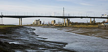
The Royal Portbury Dock is part of the Port of Bristol, in England. It is situated near the village of Portbury on the southern side of the mouth of the Avon, where the river joins the Severn estuary — the Avonmouth Docks are on the opposite side of the Avon, within Avonmouth. The deepwater dock was constructed between 1972 and 1977, and is now a major port for the import of motor vehicles into the UK. The M5 motorway runs nearby, and the huge car storage compounds around the dock are visible from the Avonmouth Bridge. A waste industrial area west of the port is being developed as the Portbury Ashlands Nature Reserve.

<span class="mw-page-title-main">Pill, Somerset</span> Human settlement in England

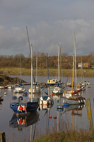
Pill is a village in North Somerset, England, situated on the southern bank of the Avon, about 4 miles (6 km) northwest of Bristol city centre. The village is the largest settlement in the civil parish of Pill and Easton-in-Gordano. The former hamlets of Lodway and Ham Green are now contiguous with Pill, and the village of Easton in Gordano is nearby. The parish extends northwest beyond the M5 motorway to include the Royal Portbury Dock.

<span class="mw-page-title-main">Avonmouth Docks</span> Port in United Kingdom

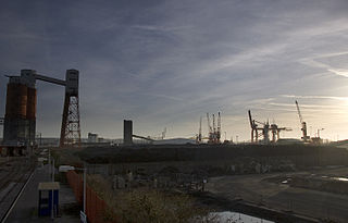
The Avonmouth Docks are part of the Port of Bristol, in England. They are situated on the northern side of the mouth of the River Avon, opposite the Royal Portbury Dock on the southern side, where the river joins the Severn estuary, within Avonmouth.

Sea Mills is a suburb of the English port city of Bristol. It is situated 3.5 miles (6 km) north-west of the city centre, towards the seaward end of the Avon Gorge, lying between the former villages of Shirehampton to the west and Westbury-on-Trym and Stoke Bishop to the east, at the mouth of the River Trym where it joins the River Avon. Sea Mills previously was part of the city ward of Kingsweston. Following a Local Government Boundary Commission review in 2015 ward boundaries were redrawn and Sea Mills is now split between the Stoke Bishop ward and the Avonmouth and Lawrence Weston ward.

<span class="mw-page-title-main">Shirehampton railway station</span> Railway station in Bristol, England

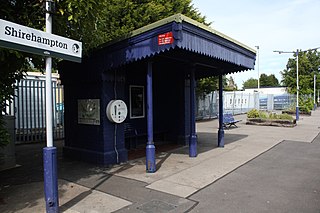
Shirehampton railway station is on the Severn Beach Line and serves the district of Shirehampton in Bristol, England. It is 7.6 miles (12.2 km) from Bristol Temple Meads. Its three letter station code is SHH. The station has a single platform which serves trains in both directions. As of 2015 it is managed by Great Western Railway, which is the third franchise to be responsible for the station since privatisation in 1997. They provide all train services at the station, mainly a train every 30 minutes in each direction.

<span class="mw-page-title-main">Avonmouth railway station</span> Railway station in Bristol, England

Avonmouth railway station is located on the Severn Beach Line and serves the district of Avonmouth in Bristol, England. It is 9.0 miles (14.5 km) from Bristol Temple Meads. Its three letter station code is AVN. The station has two platforms, on either side of two running lines. As of 2015 it is managed by Great Western Railway, which is the third franchise to be responsible for the station since privatisation in 1997. They provide all train services at the station, mainly a train every 30 minutes to Bristol Temple Meads and one every hour to Severn Beach.

The Bristol Port Railway and Pier was a railway in Bristol, England.

<span class="mw-page-title-main">Bewys Cross</span>

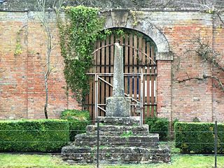
Bewys Cross is a monument consisting of the steps, plinth and truncated shaft said to be of an ancient cross of uncertain age which used to stand on the ancient seabank or seawall of the River Severn in that area of Shirehampton in Gloucestershire, United Kingdom, now known as Avonmouth. The cross is perhaps early fifteenth century; the steps may be more recent.

Rail services in the West of England refer to passenger rail journeys made in the Bristol commuter area. 17 million passenger rail journeys were made in 2019-20 within the Gloucestershire, Wiltshire and Bristol/Bath region.

Kingsweston was a ward of the city of Bristol. The three districts in the ward wer Coombe Dingle, Lawrence Weston and Sea Mills. The ward takes its name from the old district of Kings Weston, now generally considered part of Lawrence Weston. Following a Local Government Boundary Commission review in 2015 ward boundaries were redrawn and Kingsweston ward is now split between the Stoke Bishop ward and the Avonmouth and Lawrence Weston ward.

<span class="mw-page-title-main">Portway, Bristol</span> A4 road in Bristol, UK

The Portway is a major road in the City of Bristol. It is part of the A4 and connects Bristol City Centre to the Avonmouth Docks and the M5 motorway via the Avon Gorge.

<span class="mw-page-title-main">Lamplighters Marsh</span>

Lamplighters Marsh is a public open space and local nature reserve near Shirehampton in the city of Bristol, England. It is a narrow strip of land between the railway line which connects Bristol to Avonmouth, and the River Avon.

<span class="mw-page-title-main">Portway Park & Ride railway station</span> Railway station in City of Bristol, the UK

Portway Park & Ride is a railway station on the Severn Beach line in the Avonmouth district of Bristol, England. The station is about 5 miles (8.0 km) north-west of Bristol city centre and close to the M5 motorway. It serves the Portway park and ride facility on the A4 Portway, and opened on 1 August 2023 as part of the MetroWest package of improvements to railways in the area.

References

  1. "Hazardous Chemicals and Control of Major Accident Hazards (COMAH)". Bristol City Council. Retrieved 14 November 2015.
  2. "Chemical experts check 'contaminated' land at Avonmouth". BBC. Retrieved 14 November 2015.
  3. "Consultation update on proposed new gas-fired power station" (PDF). SSE. Retrieved 14 November 2015.
  4. "Site investigation underway for Bristol box terminal Avonmouth,Bristol, Bristol Port Company, Container terminals,". 13 December 2010. Archived from the original on 18 July 2011. Retrieved 13 December 2010.
  5. Watts, Victor, ed. (2010), "Avonmouth", The Cambridge Dictionary of English Place-Names, Cambridge University Press, ISBN   9780521168557
  6. 1 2 3 4 5 Richard Coates (2013). "The street-names of Shirehampton and Avonmouth" (PDF). Retrieved 14 April 2019.
  7. Great Britain Historical GIS / University of Portsmouth, Shirehampton, Gloucestershire . Retrieved {{{accessdate}}}.
  8. E.Thomas - Shirehampton Story p.187-196 (1993)
  9. E.Thomas - Down the 'Mouth (1992) pp.38-45
  10. Ordnance Survey 25" map of area (1879)
  11. Richard Coates - A Short History of West Town http://www.shire.org.uk/content/history/West%20Town.pdf
  12. London Gazette 5 November 1886
  13. Mike Oakley (2006). Bristol Railway Stations 1840-2005. Redcliffe. pp. 38–40. ISBN   1-904537-54-5.
  14. "Avonmouth St Andrew". National Churches Trust. Retrieved 21 December 2022.
  15. "The Twyning Green (J8) to Edithmead (J22) section of M5". The Motorway Archive. Archived from the original on 9 March 2009. Retrieved 14 April 2019.
  16. "Avonmouth: Four people killed in large explosion near Bristol". Sky News. Retrieved 3 December 2020.
  17. "Avonmouth water works explosion: Four people killed". BBC News. 3 December 2020. Retrieved 3 December 2020.
  18. "Planning Application" (PDF). Bristol City Council. Archived from the original (PDF) on 17 November 2015. Retrieved 14 November 2015.
  19. "Site Details". Severnside Birds. Retrieved 14 November 2015.
  20. "Avonmouth Wind Turbine - Water Vole Mitigation". EcoSulis. Retrieved 14 November 2015.
  21. "The Range opens one of the largest distribution centres in the UK - eDelivery.net". eDelivery.net. 29 June 2017. Retrieved 6 September 2017.
  22. "Central Park". centralparkbristol.co.uk. Retrieved 6 September 2017.
  23. "Bristol City Council – Find councillors".
  24. "St Andrew". A Church Near You. Retrieved 8 April 2018.
  25. 1991 census data; 2001 data not readily separable from Avonmouth.