Portway, Bristol

Last updated

The Portway running alongside the Avon Gorge The Portway - geograph.org.uk - 252873.jpg
The Portway running alongside the Avon Gorge

The Portway is a major road in the City of Bristol. It is part of the A4 and connects Bristol City Centre to the Avonmouth Docks and the M5 motorway via the Avon Gorge.

Contents

The road was constructed following World War I in order to provide improved access to the ports at Avonmouth Docks, which had replaced Bristol Harbour as the major local centre for commercial shipping. Upon opening on 2 July 1926, it was the single most expensive road project in Britain, costing £800,000 (now about £49 million). The construction posed a number of significant engineering challenges, including long and deep rock cuttings, a viaduct over the River Trym, and retaining walls against the gorge adjacent to the River Avon. Falling rocks have since been a problem along the Portway, particularly at the southern end close to the Clifton Suspension Bridge, with concrete canopies constructed to prevent loose rock and assist with remedial work.

The Portway remains an important route to and from Bristol, and is now used as part of the Portway Park and Ride scheme. In the 21st century, the road has been regularly shut to motor traffic for maintenance, providing sporting events such as the Bristol Half Marathon, or to allow locals to enjoy a traffic-free view of the Avon Gorge.

Route

The road is about 5 miles (8 km) long. Commonly it's thought to start in Hotwells, however, it starts at the junction of Bridge Valley Road and Hotwell Road below the Clifton Suspension Bridge and runs alongside the Avon Gorge, parallel to the River Avon. It passes through the suburb of Sea Mills, where it crosses the River Trym, and Shirehampton, before terminating at a roundabout in Avonmouth at a junction with the M5 motorway and A403 road. [1]

For much of its length the Portway is close to the Severn Beach railway line. Sea Mills and Shirehampton stations are near the Portway, but they have no immediate access to it. [1] First Bus run the Portway Park and Ride service, which is also a commuter service passing through some of the suburbs. [2] Although FirstGroup run the majority of bus services around Bristol, none of their other services apart from the Portway Park and Ride stop on the Portway [3] - however the X5 uses it as an access route to the M5.

Construction

Construction of the Portway was difficult owing to the unstable and unpredictable rock gorge and the presence of the River Avon. Avon Gorge - geograph.org.uk - 1161745.jpg
Construction of the Portway was difficult owing to the unstable and unpredictable rock gorge and the presence of the River Avon.

The Portway was planned by the Bristol Corporation in response to the decline of Bristol Harbour in the late 19th century in favour of Avonmouth Docks, which could handle larger vessels and containers. [4] Construction started in May 1919, engineered by L. S. McKenzie. The southern section connected to the existing road network at Hotwells, and a portion of the new road near Clifton lay partly on the line of the Bristol Port Railway. The new build did not directly connect to Avonmouth Docks, but linked to the existing road via Shirehampton about half a mile from the dock gates. [4] [5] The original plan was to build a tramway along the length of the road, which would have linked Avonmouth to the Bristol Tramway system, but this was abandoned owing to cost. [6]

The largest cutting on the construction was at Horseshoe Bend. It was 2,400 feet (730 m) long and cut 90 feet (27 m) into the rock at its deepest point. Upstream from this, a viaduct was needed to span the River Trym and the remains of an early 18th century harbour. It was composed of six 42-foot, 6-inch (12.95 m) arches, with abutments embedded in the rock 14 feet (4.3 m) below. It was supported by three piers at 17 feet (5.2 m), 21 feet (6.4 m) and 40 feet (12 m) below road level. Construction of the viaduct was delayed owing to the tidal flow of the River Avon and the irregularity of the rock. A skew girder bridge was constructed to cross the Severn Beach Railway near Sea Mills station, with foundations up to 55 feet (17 m) below the surface. Around 3,000 feet (910 m) of retaining wall was required at the Bristol end, where the road was sandwiched between the River Avon and the side of the gorge. [5] [6] In September 1924, approximately 200 yards (180 m) of newly constructed concrete embankment slid into the river following ground subsidence, posing a hazard to navigation and adding 12 months to the duration of the work, though there were no injuries. [7]

The Portway crosses the River Trym on a six-arch viaduct near Sea Mills. Road bridge and footbridge across the River Trym, Sea Mills, Bristol (geograph 3028879).jpg
The Portway crosses the River Trym on a six-arch viaduct near Sea Mills.

The Portway was opened by the Minister of Transport, Colonel Wilfrid Ashley with the Lord Mayor of Bristol, Alderman Moore, on 2 July 1926. Following an opening ceremony, the Minister and Lord Mayor drove along the full extent of the road from Bristol to inspect the docks at Avonmouth. It was the most expensive road construction project in Britain, costing £800,000 (now £49,399,000). Of that, £160,000 (now £9,880,000) was spent on the cutting at Horseshoe Bend, £80,000 (now £4,940,000) on the Trym viaduct, and £33,000 (now £2,038,000) on the steel girder bridge. [4] [5]

Electric lighting was provided to illuminate the new road, but for one year after the opening the lights were kept switched off following objections from river pilots who argued that they would make it hard to distinguish the navigation lights of shipping and the signal lights on the shore. Eventually the electric lights were turned on at a reduced brilliance. [8]

The Portway was numbered A36 when first opened. It was renumbered as a western extension of the A4 by the Ministry of Transport on 1 April 1935. [9]

Maintenance

At the southern end of the Portway by the Clifton Suspension Bridge, a concrete canopy protects against falling rocks. Clifton Suspension Bridge & the A4 Portway (geograph 2489043).jpg
At the southern end of the Portway by the Clifton Suspension Bridge, a concrete canopy protects against falling rocks.

Traffic levels increased substantially on the Portway when the M5 motorway was extended past Cribbs Causeway to meet it in 1971, as it provided a convenient way of avoiding the congested road network around north-west Bristol. Although this was only intended to be a stopgap measure until the Avonmouth Bridge was completed, construction of the bridge was repeatedly delayed. Transport Minister Keith Speed proposed a temporary solution of signing all Midlands – South West traffic via the Portway, followed by either the A369 from Bristol to Portishead northbound, or local roads southbound. The scheme required minor upgrading to junctions along the Portway. The Avonmouth Bridge opened in May 1974, making the scheme redundant. [10]

Rockfalls from the limestone cliffs of the Avon Gorge have caused a hazard to motorists on occasion and every year the road is closed to allow for inspection of the cliffs for potentially dangerous cracks and loose rocks, and to allow remedial works. [11] In 1980, a glass fibre reinforced concrete canopy was constructed over the Portway close to where it passes below the Clifton Suspension Bridge, in order to protect traffic from such rock falls. [12] [13]

In 2001, a 27-inch (690 mm) water main burst near the junction with Bridge Valley Road, causing a major collapse and putting the road out of action for several months. One passer-by was swept into the river but was rescued uninjured. [14]

Other facilities

Fun runners on the Portway in the 2006 Bristol Half Marathon. The canopy over the road under the Clifton Suspension Bridge is visible in the background. Bristol Half Marathon.jpg
Fun runners on the Portway in the 2006 Bristol Half Marathon. The canopy over the road under the Clifton Suspension Bridge is visible in the background.

The Portway Park and Ride is in Shirehampton near the M5 junction. [15] A bus lane on the inbound section of the road from Sea Mills is designed to allow quicker access for buses to the city centre. As well as Shirehampton and Sea Mills, a new station at the Park and Ride was proposed in 2009. [16] It opened on 1 August 2023. [17]

The Portway is regularly closed to through traffic in order to cater for other events besides routine maintenance. The annual Bristol Half Marathon in September uses the Portway as part of its route [18] and the annual Bristol's Biggest Bike Ride also uses the road which is closed to motor traffic for the day. [19] A series of Peaceful Portway festivals take place immediately after the sporting events while the road is still closed, allowing visitors to enjoy the scenery of the Avon Gorge without any traffic. [20] In 2009, city councillor John Rogers proposed that the Portway be closed to motor traffic on summer Sundays to allow cycling in a car free environment. [21] In 2015, the Portway was closed for five consecutive Sundays over May and June. The Mayor of Bristol, George Ferguson said the closure tied in with Big Green Week, an annual festival promoting eco-friendly activities around Bristol, where several events along the road were happening anyway. [22] [23]

Incidents

In 2014, an anonymous group constructed an 8-foot-high (2.4 m) parody of the Hollywood Sign on the Avon Gorge next to the Portway, reading "Bristoland". [24] The sign had a positive reception with commuters driving along the Portway. A few months later, the sign was briefly changed to "It's bland" without explanation, following which it was quickly removed. [25]

See also

Related Research Articles

<span class="mw-page-title-main">River Avon, Bristol</span> River in the south west of England

The River Avon is a river in the southwest of England. To distinguish it from a number of other rivers of the same name, it is often called the Bristol Avon. The name 'Avon' is loaned from an ancestor of the Welsh word afon, meaning 'river'.

<span class="mw-page-title-main">Severn Beach</span> Human settlement in England

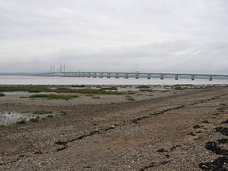
Severn Beach is a village on the Severn Estuary in South Gloucestershire, England. The eastern portal of the Severn Tunnel is on the outskirts of the village. The Severn footpath – on the sea wall – is part of the Severn Way that leads from Gloucester, Slimbridge and the Second Severn Crossing. Extensive sea defences have been constructed and this provides a popular walkway along its length. Originally, the Severn Way finished at Severn Beach, but it has been extended to Bristol.

<span class="mw-page-title-main">Avonmouth</span> Port and suburb of Bristol, England

Avonmouth is a port and outer suburb of Bristol, England, facing two rivers: the reinforced north bank of the final stage of the Avon which rises at sources in Wiltshire, Gloucestershire and Somerset; and the eastern shore of the Severn Estuary. Strategically the area has been and remains an important part of the region's maritime economy particularly for larger vessels for the unloading and exporting of heavier goods as well as in industry including warehousing, light industry, electrical power and sanitation. The area contains a junction of and is connected to the south by the M5 motorway and other roads, railway tracks and paths to the north, south-east and east.

<span class="mw-page-title-main">Avon Gorge</span> Gorge on the River Avon in Bristol, England

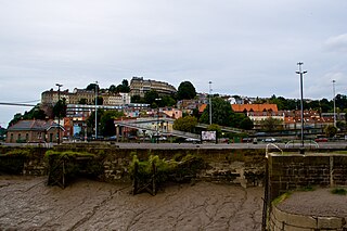
The Avon Gorge is a 1.5-mile (2.5-kilometre) long gorge on the River Avon in Bristol, England. The gorge runs south to north through a limestone ridge 1.5 miles (2.4 km) west of Bristol city centre, and about 3 miles (5 km) from the mouth of the river at Avonmouth. The gorge forms the boundary between the unitary authorities of North Somerset and Bristol, with the boundary running along the south bank. As Bristol was an important port, the gorge formed a defensive gateway to the city.

<span class="mw-page-title-main">Bristol Harbour</span> Harbour in Bristol, England

Bristol Harbour is the harbour in the city of Bristol, England. The harbour covers an area of 70 acres. It is the former natural tidal river Avon through the city but was made into its current form in 1809 when the tide was prevented from going out permanently. A tidal by-pass was dug for 2 miles through the fields of Bedminster for the river, known as the "River Avon New Cut", "New Cut", or simply "The Cut". It is often called the Floating Harbour as the water level remains constant and it is not affected by the state of the tide on the river in the Avon Gorge, The New Cut or the natural river southeast of Temple Meads to its source.

<span class="mw-page-title-main">Severn Beach line</span> Railway in Bristol and Gloucestershire, England

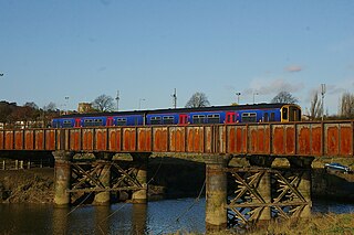
The Severn Beach line is a local railway line in Bristol and Gloucestershire, England, which runs from Bristol Temple Meads to Severn Beach, and used to extend to Pilning. The first sections of the line were opened in 1863 as part of the Bristol Port Railway and Pier; the section through Bristol was opened in 1875 as the Clifton Extension Railway.

<span class="mw-page-title-main">Shirehampton</span> Human settlement in England

Shirehampton is a district of Bristol in England, near Avonmouth, at the northwestern edge of the city.

<span class="mw-page-title-main">Avonmouth Docks</span> Port in United Kingdom

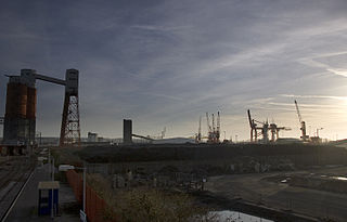
The Avonmouth Docks are part of the Port of Bristol, in England. They are situated on the northern side of the mouth of the River Avon, opposite the Royal Portbury Dock on the southern side, where the river joins the Severn estuary, within Avonmouth.

<span class="mw-page-title-main">A4018 road</span> Road in Bristol

The A4018 is an A-road connecting the city centre of Bristol to the M5 motorway at Cribbs Causeway. It is one of the four principal roads which link central Bristol to the motorway network.

Sea Mills is a suburb of Bristol, England, 3.5 miles (6 km) north-west of the city centre, towards the seaward end of the Avon Gorge, between the former villages of Shirehampton to the west and Westbury-on-Trym and Stoke Bishop to the east, at the mouth of the River Trym where it joins the River Avon. Sea Mills was part of the city ward of Kingsweston. Following a Local Government Boundary Commission review in 2015, ward boundaries were redrawn and Sea Mills is now split between the Stoke Bishop ward and the Avonmouth and Lawrence Weston ward.

<span class="mw-page-title-main">Sea Mills railway station</span> Railway station in Bristol, England

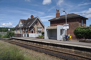
Sea Mills railway station is on the Severn Beach Line and serves the district of Sea Mills and nearby Westbury on Trym in Bristol, England. It is 6 miles (9.7 km) from Bristol Temple Meads, situated at the confluence of the River Avon and River Trym and near the A4 Bristol Portway. Its three letter station code is SML. The station has a single platform which serves trains in both directions. As of 2015 it is managed by Great Western Railway, which is the third franchise to be responsible for the station since privatisation in 1997. They provide all train services at the station, mainly a train every 30 minutes in each direction.

<span class="mw-page-title-main">Shirehampton railway station</span> Railway station in Bristol, England

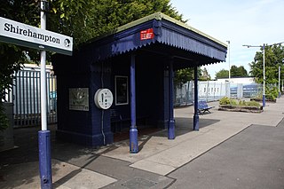
Shirehampton railway station is on the Severn Beach Line and serves the district of Shirehampton in Bristol, England. It is 7.6 miles (12.2 km) from Bristol Temple Meads. Its three letter station code is SHH. The station has a single platform which serves trains in both directions. As of 2015 it is managed by Great Western Railway, which is the third franchise to be responsible for the station since privatisation in 1997. They provide all train services at the station, mainly a train every 30 minutes in each direction.

<span class="mw-page-title-main">Avonmouth railway station</span> Railway station in Bristol, England

Avonmouth railway station is located on the Severn Beach Line and serves the district of Avonmouth in Bristol, England. It is 9.0 miles (14.5 km) from Bristol Temple Meads. Its three letter station code is AVN. The station has two platforms, on either side of two running lines. As of 2015 it is managed by Great Western Railway, which is the third franchise to be responsible for the station since privatisation in 1997. They provide all train services at the station, mainly a train every 30 minutes to Bristol Temple Meads and one every hour to Severn Beach.

<span class="mw-page-title-main">Hotwells</span> Human settlement in England

Hotwells is a district of the English port city of Bristol. It is located to the south of and below the high ground of Clifton, and directly to the north of the Floating Harbour. The southern entrance to the Avon Gorge, which connects the docks to the sea, lies at the western end of Hotwells. The eastern end of the area is at the roundabout where Jacobs Well Road meets Hotwell Road. Hotwells is split between the city wards of Clifton, and Hotwells and Harbourside.

The Bristol Port Railway and Pier was a railway in Bristol, England.

Kingsweston was a ward of the city of Bristol. The three districts in the ward were Coombe Dingle, Lawrence Weston and Sea Mills. The ward takes its name from the old district of Kings Weston, now generally considered part of Lawrence Weston. Following a Local Government Boundary Commission review in 2015 ward boundaries were redrawn and Kingsweston ward is now split between the Stoke Bishop ward and the Avonmouth and Lawrence Weston ward.

<span class="mw-page-title-main">Hotwells railway station</span> Railway station in Bristol, England

Hotwells railway station, was a railway station situated in the suburb of Hotwells in Bristol, England. It was the original southern terminus of the Bristol Port Railway and Pier which ran to a station and pier at Avonmouth. The station opened in 1865, originally named Clifton station, and was situated in the Avon Gorge almost underneath the Clifton Suspension Bridge, near the Clifton Rocks Railway, the Hotwells terminus of Bristol Tramways, the Rownham ferry and landing stages used by passenger steamers.

<span class="mw-page-title-main">Hotwells Halt railway station</span> Railway station in Bristol, England

Hotwells Halt railway station, also known as the Hotwells Extension Platform, was a railway station situated in the suburb of Hotwells in Bristol, England. It was on the Bristol Port Railway and Pier line which ran between Avonmouth and Hotwells. The station opened in 1917, and closed in 1922.

<span class="mw-page-title-main">Avonmouth railway station (Bristol Port Railway and Pier)</span> Disused railway station in Avonmouth, Bristol

Avonmouth railway station was the terminus of the Bristol Port Railway and Pier, a self-contained railway which ran along the River Avon in Bristol, England. The station, which opened in 1865, was adjacent to a pier on the River Severn at Avonmouth. It had two platforms and an adjacent hotel, as well as an engine shed and water tank. The station was closed in 1902 as the land was required for the expansion of Avonmouth Docks, although it remained in use for workers' trains until 1903. The hotel continued in operation until 1926, when it too was demolished to make way for the docks. The station site is now in the middle of Avonmouth Docks.

<span class="mw-page-title-main">Portway Park & Ride railway station</span> Railway station in City of Bristol, the UK

Portway Park & Ride is a railway station on the Severn Beach line in the Avonmouth district of Bristol, England. The station is about 5 miles (8 km) north-west of Bristol city centre and close to the M5 motorway. It serves the Portway park and ride facility on the A4 Portway, and opened on 1 August 2023 as part of the MetroWest package of improvements to railways in the area.

References

Citations

  1. 1 2 "Portway to 697 Portway". Google Maps. Retrieved 10 August 2016.
  2. "Bristol Park&Ride" (PDF). FirstBristol. Retrieved 14 July 2017.
  3. "Bristol Network" (PDF). First Group. Retrieved 10 August 2016.
  4. 1 2 3 Brodie 1942, p. 67.
  5. 1 2 3 "New Bristol Road" . The Times. Times Digital Archive. 3 July 1926. p. 11. Retrieved 10 August 2016.
  6. 1 2 Brodie 1942, p. 68.
  7. "Serious Subsidence Near Bristol: Concrete Embankment In River Bed". The Times. Times Newspapers. 29 September 1924. p. 9.
  8. A Correspondent (4 March 1929). "Shrouded Lights: Keeping The Portway Dim". The Times. Times Newspapers.
  9. "CLASSIFICATION: Re-numbering of classified routes" . The National Archives. 1933–1942.
  10. "Avonmouth Bridge (J18 to J19)". The Motorway Archive. Archived from the original on 22 September 2016. Retrieved 10 August 2016.
  11. "Downs Committee 6 July 2015" (PDF). Bristol City Council. Retrieved 29 August 2018.
  12. Hawkins, A. B. (1987). "The cliff face under the Clifton suspension bridge, Avon Gorge, Bristol" . Quarterly Journal of Engineering Geology and Hydrogeology. 20. The Geological Society: 2–4. doi:10.1144/GSL.QJEG.1987.020.01.01. S2CID   130882084 . Retrieved 14 June 2016.
  13. "Maintenance Portway,_Bristol". Brennecke. Retrieved 29 August 2018.
  14. "Portway damage could take "up to a month" to repair". BBC Bristol. BBC. 5 July 2001. Retrieved 10 August 2016.
  15. "Park and Ride Bus Service – A4 Portway (Service 902)". Bristol City Council. Archived from the original on 28 October 2009. Retrieved 23 October 2009.
  16. "Railway station could be built at Portway park and ride". Evening Post. Bristol News and Media Ltd. 13 January 2009. Archived from the original on 9 January 2010. Retrieved 10 August 2016.
  17. "Portway Park and Ride train station opens in Bristol". BBC News. 1 August 2023. Retrieved 1 August 2023.
  18. "Great Bristol Half Mararathon". Bristol Great Run (official website). Retrieved 10 August 2016.
  19. "Thousands of riders take part in annual Bristol's Biggest Bike Ride". Bristol Post. 17 June 2013. Retrieved 10 August 2016.
  20. "What is Peaceful Portway?". Peaceful Portway. 27 March 2015. Retrieved 10 August 2016.
  21. "Portway closure plans for Sundays". BBC News Bristol. BBC. 22 June 2009. Retrieved 23 October 2009.
  22. "Bristol Portway to be closed to traffic on Sundays". Bristol Post. 26 April 2015. Retrieved 10 August 2016.
  23. "7 of the best Big Green Week events coming up in June". Bristol Post. 20 May 2015. Retrieved 10 August 2016.
  24. "Bristol version of 'Hollywood' sign appears on outskirts of city". BBC News. 24 January 2014. Retrieved 10 August 2016.
  25. "Bristoland sign disappears from Avon Gorge". Bristol Post. 17 March 2014. Archived from the original on 21 March 2014. Retrieved 10 August 2016.

Sources

51°28′35″N2°38′56″W / 51.47652°N 2.64882°W / 51.47652; -2.64882