Bristol Port Railway and Pier

Last updated

The Bristol Port Railway and Pier (occasionally referred to as the Bristol Port and Pier Railway [1] ) was a railway in Bristol, England.

Contents

Route

Bristol Port Railway and Pier

  mi-ch from Hotwells

BSicon exBOOT.svg
BSicon exKHSTa.svg
5-52
Avonmouth
BSicon exABZg+l.svg
BSicon xABZq+l.svg
BSicon lCONTf@Fq.svg
BSicon exCONTgq.svg
BSicon exABZg+r.svg
BSicon LSTRe.svg
BSicon exHST.svg
Avonmouth Docks
BSicon exKDSTaq.svg
BSicon exABZg+r.svg
BSicon LSTRa.svg
Avonmouth Docks
BSicon WASSER+r.svg
BSicon xKRWg+l.svg
BSicon LKRWr.svg
BSicon WASSER.svg
BSicon eABZgnl.svg
BSicon exnKBSTeq.svg
Crown Brickyard
BSicon WASSER.svg
BSicon HST.svg
3-50
Shirehampton
BSicon WABZg+l.svg
BSicon hKRZWae.svg
BSicon dWASSERq.svg
BSicon WASSER.svg
BSicon HST.svg
2-00
Sea Mills
BSicon WASSER.svg
BSicon xABZgl.svg
BSicon CONTfq.svg
BSicon WASSER.svg
BSicon exHST.svg
Hotwells Halt
BSicon WASSER.svg
BSicon exTUNNEL1.svg
No. 2 Tunnel (
525 ft
160 m
)
BSicon WASSER.svg
BSicon extSTRa.svg
No. 1 Tunnel (
216 ft
65.8 m
)
BSicon WASSER.svg
BSicon PORTALg.svg
BSicon exKHSTe.svg
0-00
Hotwells
BSicon WASSER.svg

The Bristol Port Railway and Pier company (BPRP) ran from a main terminus at Hotwells (originally called Clifton), northwards to west of Bristol city centre between the Clifton Suspension Bridge and Bridge Valley Road, to a terminus at Avonmouth. Upon leaving Hotwells, the line ran north alongside the River Avon through two tunnels, to a halt and passing point, then to Sneyd Park Junction, where the Clifton Extension Railway joined it. Continuing north following the river is the station at Sea Mills, then a bridge over the River Trym. The line curved west around Horse-Shoe Bend, then went slightly inland to Shirehampton, then turned back north-west. At Avonmouth Dock Junction the Extension Railway diverged north, and another line diverged west for freight, while the BPRP line continued into the station at Avonmouth Docks. Beyond there, the line diverged again, with one line going west to Avonmouth (Royal Edward) and another north to rejoin the Extension Railway. The main BPRP line continued on into its Avonmouth terminus.

History

Formation

Bristol sits on the River Avon, with its docks several miles inland. By the 19th century, ships had grown to such a size that navigating the Avon was not possible any more, and they had to dock at the head of the river at Avonmouth instead. The Bristol Port Railway and Pier company (BPRP) was founded in 1862 with the intent to build a single-track 4 ft 8+12 in (1,435 mm) standard gauge railway the 5.75 miles (9.25 km) from Avonmouth to the city centre, alongside the Avon. The railway's act of parliament was passed on 17 July 1862, with Benjamin Burleigh appointed as engineer. It was the first standard gauge line in Bristol. [2] The company's headquarters was at Shirehampton, where the first sod was turned by the Mayoress of Bristol, Mrs S V Hare, on 19 February 1863. [3] The railway opened on 6 March 1865, although this was not announced in advance so that the line would not be overwhelmed by more people than the single locomotive could haul, and timetables were posted at Hotwells only minutes before the first departure. [2]

Connection to the network

As built, the railway was isolated from the rest of the national network, having not been intended for anything more than local traffic. However, with very little goods traffic, a connection to the main line railways was needed to develop Avonmouth as a port. An extension from Hotwells to the city's main station at Temple Meads would have required crossing a large amount of developed land, and so was prohibitively expensive. Instead, a link was proposed from the BPRP at Sneyd Park, running under Clifton Down to join the Midland Railway and Bristol and South Wales Union Railway.

The connection was authorised in 1867, but the BPRP was in financial difficulties and unable to attract investors. Instead, the company joined forces with the Midland and Great Western Railways to build the Clifton Extension Railway, which opened in 1877 for freight to the newly built Avonmouth Docks. [4] The double-track CER was not initially open to passengers, as although the Sneyd Park – Clifton Down section was certified for passenger use in 1878, the MR and GWR did not believe the BPRP line was in a suitable state to carry their passengers. The MR obtained parliamentary powers to install block signalling on the line at the BPRP's expense, and through trains eventually started on 1 September 1885. [2]

Buyout and legacy

Hotwells Halt was built during the First World War. Hotwells Halt Loxton.jpg
Hotwells Halt was built during the First World War.

On 25 July 1890, Parliament approved a bill allowing the Midland and Great Western to buy out the BPRP, the BPRP effectively merging with the Clifton Extension Railway from 1 September that year. [5]

Increased traffic led to the line being doubled from Avonmouth to Shirehampton in 1903, and to Sneyd Park in 1907. [3] The Avonmouth terminus closed to passengers in 1902 to allow construction of the Royal Edward Dock, although workers' trains continued into 1903. [3] Traffic on the Hotwells branch peaked in 1910 at ten trains per day and six on Sundays, and in 1917 Hotwells Halt was built to handle the large number of wartime munitions workers travelling to Avonmouth. [6] The branch was closed in 1922 to make way for construction of the A4 Portway. [2] The line from Sneyd Park Junction to Dock Junction and the stations of Shirehampton and Sea Mills survive as part of the Severn Beach Line.

Portnalls Number One Railway Tunnel, just north of Hotwells station, was used during the Second World War as an air-raid shelter by the people of Bristol. It became so popular that the City Council had to institute a pass system. The tunnel was once again used in the late twentieth century by the Bristol Gun Club, who converted a portion of it into a firing range. However, this ended following the passage of the Firearms (Amendment) (No. 2) Act 1997 which banned handguns in the United Kingdom, and the tunnel was once more abandoned. It is currently split in three parts – the firing range, a section of original tunnel, and the shelter. [7] [8]

In the 2000s subsidence and movement in the Number Two tunnel affected the road above, Bridge Valley Road, which required major stabilization work and the waterproof tanking of the tunnel, to enable the road to be reopened. [9]

Services

Initial service from March 1865 was six trains per day in each direction, with four down (Hotwells to Avonmouth) and five up (Avonmouth to Hotwells) on Sundays, [2] taking around 30 minutes for the 5.75 miles (9.25 km) trip. On weekdays the quickest was 26 minutes, and 20 minutes on Sundays as Shirehampton was closed due to objections from the local church, although this concession was reversed by May that year. [3] The fare for a single between Hotwells and Avonmouth was 1s 0d, 9d and 6d for first, second and third class respectively, with returns 6d more. [10]

By January 1866 the service was reduced to three down and four up per day, with one Shirehampton-Avonmouth except on Sundays; this increased to five up and down in April that year, with one Hotwells-Shirehampton except on Sundays. By June the service was five up and down on Sundays, and six on other days. Two extra trains per day were laid on when Avonmouth Docks was opened, and by summer 1887 there were ten up and down, with four each way and an Avonmouth-Shirehampton return on Sundays. [10]

By 1910 Avonmouth was no longer a resort, but instead a workplace, and so Sunday service was reduced to two trains each way, taking 19 minutes each. The Sunday service had been completely discontinued by 1920, with weekday service reduced to nine down and eight up, with journey times of 18 minutes, and the first two morning departures forsaking the Hotwells terminus for Hotwells Halt's longer platform. [10] From September 1921, the Halt was the terminus of the BPRP line, as the Hotwells terminus was closed to allow construction of the A4 Portway. Hotwells Halt, and the line to Sneyd Park Junction, closed on 3 July 1922, with the final train running on 1 July. [3]

According to some sources, the trains were not operated by the BPRP itself, but instead were operated under a lease agreement by the Bristol and Exeter Railway. This lease was taken over by the Great Western Railway in 1871, along with the rest of the Bristol and Exeter. [7]

Rolling stock

The BPRP had two 0-4-2 side tank locomotives, possibly from the St Helens Railway. Coaching stock was four-wheeled; there were initially 14 carriages, rising to around 20 according to some reports, all of which were disposed of when the line was taken over. The BPRP also possessed two covered and two uncovered wagons, in a light grey livery. The coaching stock was painted yellow and white, with some later painted dark chocolate. [10]

See also

Related Research Articles

<span class="mw-page-title-main">Severn Beach</span> Human settlement in England

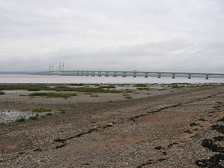
Severn Beach is a village on the Severn Estuary in South Gloucestershire, England. The eastern portal of the Severn Tunnel is on the outskirts of the village. The Severn footpath – on the sea wall – is part of the Severn Way that leads from Gloucester, Slimbridge and the Second Severn Crossing. Extensive sea defences have been constructed and this provides a popular walkway along its length. Originally, the Severn Way finished at Severn Beach, but it has been extended to Bristol.

<span class="mw-page-title-main">Avonmouth</span> Port and suburb of Bristol, England

Avonmouth is a port and outer suburb of Bristol, England, facing two rivers: the reinforced north bank of the final stage of the Avon which rises at sources in Wiltshire, Gloucestershire and Somerset; and the eastern shore of the Severn Estuary. Strategically the area has been and remains an important part of the region's maritime economy particularly for larger vessels for the unloading and exporting of heavier goods as well as in industry including warehousing, light industry, electrical power and sanitation. The area contains a junction of and is connected to the south by the M5 motorway and other roads, railway tracks and paths to the north, south-east and east.

<span class="mw-page-title-main">Severn Beach line</span> Railway in Bristol and Gloucestershire, England

The Severn Beach line is a local railway line in Bristol and Gloucestershire, England, which runs from Bristol Temple Meads to Severn Beach, and used to extend to Pilning. The first sections of the line were opened in 1863 as part of the Bristol Port Railway and Pier; the section through Bristol was opened in 1875 as the Clifton Extension Railway.

<span class="mw-page-title-main">Pilning railway station</span> Railway station near Bristol, England

Pilning railway station is a minor station on the South Wales Main Line near Pilning, South Gloucestershire, England. It is 10 miles (16 km) from Bristol Temple Meads and is the last station on the English side before the Severn Tunnel through to Wales. It is managed by Great Western Railway, who provide the two train services per week from the station.

<span class="mw-page-title-main">Stapleton Road railway station</span> Railway station in Bristol, England

Stapleton Road railway station is on the Severn Beach Line and Cross Country Route, serving the inner-city district of Easton in Bristol, England. It is 1.6 miles (2.6 km) from Bristol Temple Meads. Its three letter station code is SRD. The station has two platforms, four running lines and minimal facilities. It is managed by Great Western Railway, the seventh company to be responsible for the station, and the third franchise since privatisation in 1997. They provide all train services at the station, the standard service being two trains per hour along the Severn Beach Line and an hourly service between Bristol Temple Meads and Filton Abbey Wood.

<span class="mw-page-title-main">Avonmouth Docks</span> Port in United Kingdom

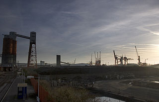
The Avonmouth Docks are part of the Port of Bristol, in England. They are situated on the northern side of the mouth of the River Avon, opposite the Royal Portbury Dock on the southern side, where the river joins the Severn estuary, within Avonmouth.

<span class="mw-page-title-main">Montpelier railway station</span> Railway station in Bristol, England

Montpelier railway station is on the Severn Beach Line and serves the district of Montpelier in Bristol, England. It is 2.85 miles (4.59 km) from Bristol Temple Meads. Its three letter station code is MTP. The station has a single platform, serving trains in both directions. As of 2015 it is managed by Great Western Railway, which is the third franchise to be responsible for the station since privatisation in 1997. They provide all train services at the station, mainly a train every 30 minutes in each direction.

<span class="mw-page-title-main">Clifton Down railway station</span> Railway station in Bristol, England

Clifton Down railway station is on the Severn Beach line and serves the district of Clifton in Bristol, England. It is 3.9 miles (6.3 km) from Bristol Temple Meads. Its three letter station code is CFN. The station has two platforms, each serving trains in one direction only. As of 2015 it is managed by Great Western Railway, which is the third franchise to be responsible for the station since privatisation in 1997. They provide all train services at the station, mainly a train every 30 minutes in each direction.

<span class="mw-page-title-main">Portishead Railway</span>

The Portishead Railway is a branch line railway running from Portishead in North Somerset to the main line immediately west of Bristol, England. It was constructed by the Bristol & Portishead Pier and Railway Company, but it was always operated by its main line neighbour, and was more usually thought of as the Portishead branch or the Portishead railway.

<span class="mw-page-title-main">Sea Mills railway station</span> Railway station in Bristol, England

Sea Mills railway station is on the Severn Beach Line and serves the district of Sea Mills and nearby Westbury on Trym in Bristol, England. It is 6 miles (9.7 km) from Bristol Temple Meads, situated at the confluence of the River Avon and River Trym and near the A4 Bristol Portway. Its three letter station code is SML. The station has a single platform which serves trains in both directions. As of 2015 it is managed by Great Western Railway, which is the third franchise to be responsible for the station since privatisation in 1997. They provide all train services at the station, mainly a train every 30 minutes in each direction.

<span class="mw-page-title-main">Shirehampton railway station</span> Railway station in Bristol, England

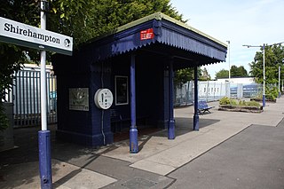
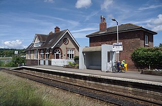
Shirehampton railway station is on the Severn Beach Line and serves the district of Shirehampton in Bristol, England. It is 7.6 miles (12.2 km) from Bristol Temple Meads. Its three letter station code is SHH. The station has a single platform which serves trains in both directions. As of 2015 it is managed by Great Western Railway, which is the third franchise to be responsible for the station since privatisation in 1997. They provide all train services at the station, mainly a train every 30 minutes in each direction.

<span class="mw-page-title-main">Avonmouth railway station</span> Railway station in Bristol, England

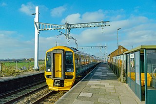
Avonmouth railway station is located on the Severn Beach Line and serves the district of Avonmouth in Bristol, England. It is 9.0 miles (14.5 km) from Bristol Temple Meads. Its three letter station code is AVN. The station has two platforms, on either side of two running lines. As of 2015 it is managed by Great Western Railway, which is the third franchise to be responsible for the station since privatisation in 1997. They provide all train services at the station, mainly a train every 30 minutes to Bristol Temple Meads and one every hour to Severn Beach.

<span class="mw-page-title-main">Clifton Extension Railway</span>

The Clifton Extension Railway was a joint railway in Bristol, owned by the Great Western Railway (GWR) and the Midland Railway (MR) companies.

<span class="mw-page-title-main">Bristol and South Wales Union Railway</span>

The Bristol and South Wales Union Railway was built to connect Bristol, England, with south Wales. The route involved a ferry crossing of the River Severn but was considerably shorter than the alternative route through Gloucester. The ferry was replaced by the Severn Tunnel in 1886 but part of the route continues to be used, forming parts of the Cross-Country Route and the South Wales Main Line.

<span class="mw-page-title-main">Portway, Bristol</span> A4 road in Bristol, UK

The Portway is a major road in the City of Bristol. It is part of the A4 and connects Bristol City Centre to the Avonmouth Docks and the M5 motorway via the Avon Gorge.

<span class="mw-page-title-main">Clifton Bridge railway station</span> Former railway station in England

Clifton Bridge railway station is a former railway station in the Bower Ashton district of Bristol, England, near the River Avon. It was opened in 1867 by the Bristol and Portishead Pier and Railway Company as a single platform stop 3.4 miles (5.5 km) along the line from Bristol to Portishead. It was later taken over by the Great Western Railway and had a second platform added.

<span class="mw-page-title-main">Hotwells railway station</span> Railway station in Bristol, England

Hotwells railway station, was a railway station situated in the suburb of Hotwells in Bristol, England. It was the original southern terminus of the Bristol Port Railway and Pier which ran to a station and pier at Avonmouth. The station opened in 1865, originally named Clifton station, and was situated in the Avon Gorge almost underneath the Clifton Suspension Bridge, near the Clifton Rocks Railway, the Hotwells terminus of Bristol Tramways, the Rownham ferry and landing stages used by passenger steamers.

<span class="mw-page-title-main">Hotwells Halt railway station</span> Railway station in Bristol, England

Hotwells Halt railway station, also known as the Hotwells Extension Platform, was a railway station situated in the suburb of Hotwells in Bristol, England. It was on the Bristol Port Railway and Pier line which ran between Avonmouth and Hotwells. The station opened in 1917, and closed in 1922.

<span class="mw-page-title-main">Avonmouth railway station (Bristol Port Railway and Pier)</span> Disused railway station in Avonmouth, Bristol

Avonmouth railway station was the terminus of the Bristol Port Railway and Pier, a self-contained railway which ran along the River Avon in Bristol, England. The station, which opened in 1865, was adjacent to a pier on the River Severn at Avonmouth. It had two platforms and an adjacent hotel, as well as an engine shed and water tank. The station was closed in 1902 as the land was required for the expansion of Avonmouth Docks, although it remained in use for workers' trains until 1903. The hotel continued in operation until 1926, when it too was demolished to make way for the docks. The station site is now in the middle of Avonmouth Docks.

<span class="mw-page-title-main">Portway Park & Ride railway station</span> Railway station in City of Bristol, the UK

Portway Park & Ride is a railway station on the Severn Beach line in the Avonmouth district of Bristol, England. The station is about 5 miles (8 km) north-west of Bristol city centre and close to the M5 motorway. It serves the Portway park and ride facility on the A4 Portway, and opened on 1 August 2023 as part of the MetroWest package of improvements to railways in the area.

References

  1. Map of Bristol circa 1880
  2. 1 2 3 4 5 Maggs, Colin G (2008) [1981]. Rail Centres: Bristol. Rail Centres. Vol. 21 (3rd ed.). Nottingham: Booklaw Publications. pp. 15–16, 40. ISBN   1-901945-30-8.
  3. 1 2 3 4 5 Oakley, Mike (2006). Bristol Railway Stations 1840–2005. Redcliffe. ISBN   1-904537-54-5.
  4. Maggs, Colin G (1981). Rail Centres: Bristol. Rail Centres. Vol. 21 (1st ed.). Ian Allan Publishing. ISBN   0-7110-1153-2.
  5. "History". Bristol Harbour Railway. Retrieved 13 March 2015.
  6. Yorke, Stan (2007). Lost Railways of Somerset. Newbury, Somerset: Countryside Books. pp. 127–131. ISBN   978-1-84674-057-2.
  7. 1 2 "Bridge Valley Road Deep Shelter, Bristol". Forlorn Britain. Archived from the original on 6 June 2011. Retrieved 20 May 2011.
  8. "Bridge Valley Road Deep Shelter, Bristol". TheTimeChamber. Retrieved 20 May 2011.
  9. "Bridge valley road stabilisation works" . Retrieved 13 March 2015.
  10. 1 2 3 4 Maggs, Colin G (1975). The Bristol Port Railway & Pier. The Oakwood Library of Railway History. Vol. 37 (1st ed.). The Oakwood Press. ISBN   0-85361-176-9.

51°29′10″N2°40′44″W / 51.4862°N 2.679°W / 51.4862; -2.679