Cumberland Basin (Bristol)

Last updated

Cumberland Basin
Cumberland Basin.jpg
The basin looking eastwards
Bristol UK location map.svg
Red pog.svg
Cumberland Basin
Location within Bristol
Coordinates: 51°26′53″N2°37′10″W / 51.44806°N 2.61944°W / 51.44806; -2.61944
Country England
City Bristol
District Hotwells
Established1804-9

The Cumberland Basin is the main entrance to the docks of the city of Bristol, England. It separates the areas of Hotwells from the tip of Spike Island.

Contents

MV Balmoral in Cumberland Basin Mvbalmoral2.JPG
MV Balmoral in Cumberland Basin

History

Aerial photograph of the Cumberland Basin, 1930s Target Dossier for Bristol, Gloucestershire, England - DPLA - 22972aeaa7dac3a664b6b86eb0bc588e (page 3).jpg
Aerial photograph of the Cumberland Basin, 1930s

The River Avon never flowed through the Cumberland Basin. Before the 19th century improvements and the construction of the non-tidal Floating Harbour, the Avon flowed through the tidal harbour and out through the future location of the Underfall Yard. When the basin and Floating Harbour were constructed the river was diverted through the New Cut, bypassing the harbour entirely.

Following competition from other ports, in 1802 William Jessop proposed installing a dam and lock at Hotwells to create the harbour. The £530,000 scheme was approved by Parliament, and construction began in May 1804. The scheme included the construction of the Cumberland Basin, a large wide stretch of the harbour in Hotwells where the Quay walls and bollards have listed building status. [1] [2]

The new scheme required a way to equalise the levels inside and outside the Dock for the passage of vessels to and from the Avon, and bridges to cross the water. Jessop built Cumberland Basin with two entrance locks from the tidal Avon, of width 45 ft (13.7 m) and 35 ft (10.7 m), and a 45 feet (13.7 m) wide junction lock between the Basin and what became known as the Floating Harbour. This arrangement provided flexibility of operation with the Basin being used as a lock when there were large numbers of arrivals and sailings. The harbour was officially opened on 1 May 1809. [3] The first alteration was the construction of the south junction lock which was completed in 1849 and had a single-leaf wrought-iron gate. It is no longer used and has been sealed by a concrete wall. [4]

In 1831 a terrace of eight houses were built for the Bristol Docks Company. [5] [6] In 1870 a hydraulic pump house was built by Thomas Howard to power the bridges and machinery. It has since been converted into the Pump House pub, [7] with hydraulic power being provided from the Hydraulic engine house at the Underfall Yard.

Swing bridges

When Brunel rebuilt the entrance locks of the Cumberland Basin in Bristol Harbour, between 1848 and 1849, he also constructed a number of swinging bridges – Brunel's first moving bridges. [8] These were of centre-pivot construction, but were highly asymmetrical, the outboard side being nearly three times longer than the landward, balanced by large cast iron counterweights. [8]

As the bridges were for light roadways and did not have to carry the weight of a railway or train, their girders were of a lightweight construction, known as Balloon flange girders that simplified manufacture. A full balloon upper flange was used, similar in shape to the South Wales Railway bridges, but the flange sat above the main web of the girder and the web did not span the flange and reach to the top. This simplified construction as it avoided the T-joint, the necessary L-strips and thus several rows of riveting. [8] The lower flange was of an entirely novel form, being triangular in section, although with concave sides. Again, the main web did not span the flange. All three joints were now simple lap joints with single-row riveting. [8]

One of the bridges was moved from the south entrance lock to the north entrance dock in 1873. It was originally hand cranked and later adapted to use hydraulic power. [9] It became redundant in the 1960s when it was replaced by the large Plimsoll Swing Bridge and was left on the side of the dock partially beneath the new bridge. [10] It is now known as "Brunel's other bridge" to differentiate it from the nearby Clifton Suspension Bridge. [11] The old Junction Lock swing bridge was originally powered by water pressure from the Underfall Yard hydraulic engine house at 750  psi (52  bar ) but was converted to electro hydraulic with PLC control in 2010 by KPR Engineering. [12] The new Plimsoll Bridge, completed in 1965, utilises a similar electro-hydraulic system using oil at a pressure of 4,480 psi (309 bar). [3]

Like a number of early Brunel bridges, Brunel's involvement with them was largely forgotten and only recorded in obscure works. [13] At one point they were under serious threat of demolition until their historical significance was re-recognised. Brunel's other bridge is listed on the Heritage at Risk Register. [14] A £1 million appeal was launched in 2014 to restore the bridge, [11] [15] and English Heritage has offered a grant towards its restoration. [14] In 2019, after work by volunteers from Avon Industrial Buildings Trust, a grant of £62,000 has been awarded by Historic England for restoration work. [16]

Bristolharbourmap.png

  1. Prince's Wharf, including M Shed, Pyronaut and Mayflower adjoining Prince Street Bridge
  2. Dry docks: SS Great Britain, the Matthew
  3. St Augustine's Reach, Pero's Bridge
  4. Bathurst Basin
  5. Queen Square
  6. Bristol Temple Meads railway station
  7. Castle Park
  8. Redcliffe Quay and Redcliffe Caves
  9. Baltic Wharf marina
  10. Cumberland Basin & Brunel Locks
  11. The New Cut
  12. Netham Lock, entrance to the Feeder Canal
  13. Totterdown Basin
  14. Temple Quay
  15. The Centre
  16. Canons Marsh, including Millennium Square and We The Curious
  17. Underfall Yard
  18. Bristol Bridge and Welsh Back

Future plans

The elevated road network built in the 1960s which forms the majority of land at the Cumberland Basin is nearing the end of its intended lifespan. Since 2015, plans have existed to redevelop the area. [17] Bristol mayor Marvin Rees announced in 2017 the intention to regenerate the area under the name Western Harbour, a name referring to the area at the westerly entrance to the historic Floating Harbour, including the areas immediately to the north and south. [18] In August 2019, a public consultation began seeking local residents' views on the area's future, including new bridges and housing options. [19] In 2021, Bristol City Council announced a six-month period of community engagement into the area, in order to develop a vision for its future transformation. [18]

Related Research Articles

<span class="mw-page-title-main">River Avon, Bristol</span> River in the south west of England

The River Avon is a river in the southwest of England. To distinguish it from a number of other rivers of the same name, it is often called the Bristol Avon. The name 'Avon' is loaned from an ancestor of the Welsh word afon, meaning 'river'.

<span class="mw-page-title-main">Bristol Harbour</span> Harbour in Bristol, England

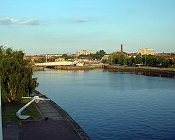
Bristol Harbour is the harbour in the city of Bristol, England. The harbour covers an area of 70 acres. It is the former natural tidal river Avon through the city but was made into its current form in 1809 when the tide was prevented from going out permanently. A tidal by-pass was dug for 2 miles through the fields of Bedminster for the river, known as the "River Avon New Cut", "New Cut", or simply "The Cut". It is often called the Floating Harbour as the water level remains constant and it is not affected by the state of the tide on the river in the Avon Gorge, The New Cut or the natural river southeast of Temple Meads to its source.

<span class="mw-page-title-main">Spike Island, Bristol</span> Human settlement in England

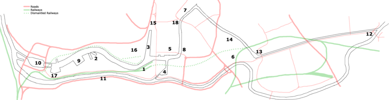
Spike Island is an inner city and harbour area of the English port city of Bristol, adjoining the city centre. It comprises the strip of land between the Floating Harbour to the north and the tidal New Cut of the River Avon to the south, from the dock entrance to the west to Bathurst Basin in the east. The island forms part of Cabot ward. The area between the Docks and New cut to the east of Bathurst Basin is in the neighbourhoods of Redcliffe and St Philip's Marsh.

<span class="mw-page-title-main">Avonmouth Docks</span> Port in United Kingdom

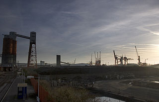
The Avonmouth Docks are part of the Port of Bristol, in England. They are situated on the northern side of the mouth of the River Avon, opposite the Royal Portbury Dock on the southern side, where the river joins the Severn estuary, within Avonmouth.

<span class="mw-page-title-main">Cabot, Bristol (former ward)</span> Human settlement in England

Cabot was a council ward that covered the centre of Bristol, England. It took its name from the Cabot Tower, a memorial tower on Brandon Hill that was built to commemorate John Cabot's voyage and "discovery" of North America. The ward was abolished in 2016.

<span class="mw-page-title-main">Castle Park, Bristol</span>

Castle Park is a public open space in Bristol, England, managed by Bristol City Council. It is bounded by the Floating Harbour and Castle Street to the south, Lower Castle Street to the east, and Broad Weir, Newgate and Wine Street to the north. Its western boundary is less obviously defined and has been the subject of controversy, perhaps because the area around High Street and St Mary le Port Church, though not part of the park and always intended for development, is often considered at the same time as the park.

<span class="mw-page-title-main">Bristol Bridge</span> Historic bridge in United Kingdom

Bristol Bridge is a bridge over the floating harbour in Bristol, England. The floating harbour was constructed on the original course of the River Avon, and there has been a bridge on the site since long before the harbour was created by impounding the river in 1809. The current bridge was completed in 1768 and is a Grade II listed building.

<span class="mw-page-title-main">Netham Lock</span>

Netham Lock is the point at Netham in Bristol at which boats from the River Avon, acting as part of the Kennet and Avon Canal, gain access to Bristol's Floating Harbour.

<span class="mw-page-title-main">Hydraulic engine house, Bristol Harbour</span> Building in Bristol, England

The Hydraulic engine house is part of the "Underfall Yard" in Bristol Harbour in Bristol, England.

<span class="mw-page-title-main">Pump House, Bristol</span> Building in Bristol, England

The Pump House is an historic pub in Hotwells on Bristol Harbour, Bristol, England. It is a grade II listed building.

<span class="mw-page-title-main">Underfall Yard</span> Boatyard in Bristol with mechanism for maintaining water and silt levels in the harbour

The Underfall Yard is a historic boatyard on Spike Island serving Bristol Harbour in England.

<span class="mw-page-title-main">Bathurst Basin</span>

Bathurst Basin is a small triangular basin adjoining the main harbour of the city of Bristol, England. The basin takes its name from Charles Bathurst, who was a Bristol MP in the early 19th century.

<span class="mw-page-title-main">New Cut, Bristol</span> River in Bristol, England

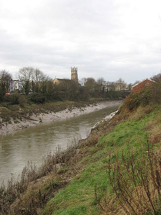
The New Cut is an artificial waterway which was constructed between 1804 and 1809 to divert the tidal river Avon through south and east Bristol, England. This was part of the process of constructing Bristol's Floating Harbour, under the supervision of engineer William Jessop. The cut runs from Totterdown Basin at the eastern end of St Phillip's Marsh, near Temple Meads, to the Underfall sluices at Rownham in Hotwells and rejoining the original course of the tidal Avon.

<span class="mw-page-title-main">The Centre, Bristol</span> Open space in Bristol, England, UK

The Centre is a public open space in the central area of Bristol, England, created by covering over the River Frome. The northern end of The Centre, known as Magpie Park, is skirted on its western edge by Colston Avenue; the southern end is a larger paved area bounded by St Augustine's Parade to the west, Broad Quay the east, and St Augustine's Reach to the south, and bisected by the 2016 extension of Baldwin Street. The Centre is managed by Bristol City Council.

<span class="mw-page-title-main">Balloon flange girder</span>

A balloon flange girder or (colloquially) balloon topper is a form of vertical I-beam wrought iron plate girder, where the top flange, instead of being a simple flat plate, is extended into a hollow tube. When a girder is subjected to a positive bending moment the top flange acts in compression making a flat plate flange more susceptible to local buckling than the balloon flange is.

<span class="mw-page-title-main">Ashton Avenue Bridge</span> Bridge in Bristol, England

The Ashton Avenue Bridge is a pedestrian, cycling and busway bridge in Bristol, England. Grade II listed, it was constructed as a road-rail bridge as part of the Bristol Harbour Railway. It now carries a Bristol MetroBus guided busway route and National Cycle Network cycle routes.

<span class="mw-page-title-main">Temple Quay</span>

Temple Quay is an area of mixed-use development in central Bristol, England. The project was initiated by Bristol Development Corporation in 1989, under the name Quay Point until 1995. In that year it was handed over to English Partnerships, under whom development eventually started in 1998. It is bounded by Temple Way to the west and Bristol Temple Meads railway station to the southeast; to the northeast the development was bounded by Bristol Floating Harbour until 2002, when development of Temple Quay North started on the harbour's other side. In 2012 the whole area became part of Bristol Temple Quarter Enterprise Zone.

<span class="mw-page-title-main">Bristol Feeder Canal</span>

The Bristol Feeder Canal is a body of water in Bristol, England, that connects the Floating Harbour with the River Avon.

<span class="mw-page-title-main">Redcliffe Caves</span> Tunnels in Bristol, England

Redcliffe Caves are a series of man made tunnels beneath the Redcliffe area of Bristol, England.

<span class="mw-page-title-main">Welsh Back, Bristol</span> Wharf and street in the city of Bristol, England

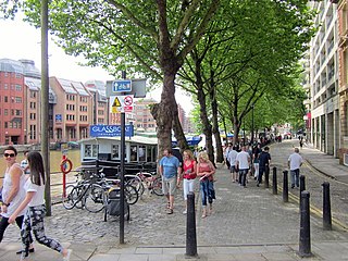
Welsh Back is a wharf and street alongside the floating harbour in the centre of the city of Bristol, England. The wharf and street extend some 450 metres (1,480 ft) along the west side of the harbour between Bristol Bridge and Redcliffe Bridge. At the northern end, the street and wharf are immediately adjacent, but to the south they are separated by a range of single story transit sheds. The wharf is a grade II listed structure and takes its name because it was freqented by vessels from Welsh ports.

References

  1. Historic England. "Quay walls and bollards (1202185)". National Heritage List for England . Retrieved 18 August 2006.
  2. Historic England. "Quay walls and bollards around Cumberland Basin (1202185)". National Heritage List for England . Retrieved 22 March 2015.
  3. 1 2 "The creation of Bristol City docks". Farvis. Archived from the original on 2 April 2015. Retrieved 22 March 2015.
  4. Historic England. "Brunel's South Entrance Lock (1207824)". National Heritage List for England. Retrieved 22 March 2015.
  5. Historic England. "Nos.1-5 (Consecutive) Old Dock Cottages (1279554)". National Heritage List for England. Retrieved 22 March 2015.
  6. Historic England. "Nos.6, 7 AND 8 Old Dock Cottages (1202184)". National Heritage List for England. Retrieved 22 March 2015.
  7. Historic England. "The Pump House Public House (1279539)". National Heritage List for England. Retrieved 22 March 2015.
  8. 1 2 3 4 Isambard Brunel Junior (2006) [1870]. The Life of Isambard Kingdom Brunel, Civil Engineer. STEAM / Nonsuch Publishing. pp. 146–149. ISBN   978-1845880316.
  9. Fells, Maurice (2014). The A-Z of Curious Bristol. History Press. pp. 17–18. ISBN   978-0750956055.
  10. "Cumberland Basin Bridges (Bristol)". Grace's Guide. Retrieved 22 March 2015.
  11. 1 2 "Brunel's other bridge in Bristol may be repaired as £1m appeal launched". BBC News Online. 10 October 2014.
  12. "KPR £12M Historical I.K. Brunel Contract at Cumberland Basin Bristol UK". KPR Engineering. Retrieved 12 April 2017.
  13. Buchanan, Angus; Williams, Michael (1982). Brunel's Bristol. Redcliffe Press. p. 31. ISBN   0905459393.
  14. 1 2 "Swing Bridge over North Entrance Lock, Cumberland Basin, Bristol - Bristol, City of (UA)". Heritage at Risk. Historic England. Retrieved 22 March 2015.
  15. "Brunel's Other Bridge". Brunel's Other Bridge Committee. Retrieved 22 March 2015.
  16. "Brunel's 'other bridge' in Bristol to be 'saved with £62k grant". BBC. Retrieved 3 September 2019.
  17. "Pictures show potential for development around Cumberland Basin". Bristol Live. 19 August 2019. Retrieved 19 August 2019.
  18. 1 2 "Western Harbour". bristol.gov.uk. 21 July 2021. Retrieved 21 July 2021.
  19. "Cumberland Basin: Major Bristol road consultation begins". BBC News. 19 August 2019. Retrieved 19 August 2019.

Commons-logo.svg Media related to Cumberland Basin at Wikimedia Commons