The Centre, Bristol

Last updated

The Centre, Bristol
Northern end of The Centre, Bristol, March 2018.jpg
View of northern end of The Centre, March 2018, before removal of Colston statue
Location map United Kingdom Bristol Central1.png
Red pog.svg
Location within Central Bristol
Former name(s) Tramways Centre
Maintained by Bristol City Council
Location Bristol, England
Postal code BS1
Coordinates 51°27′14″N2°35′50″W / 51.4540°N 2.5972°W / 51.4540; -2.5972 Coordinates: 51°27′14″N2°35′50″W / 51.4540°N 2.5972°W / 51.4540; -2.5972
North Lewins Mead, Rupert Street
East Baldwin Street
South Anchor Road
West College Green

The Centre is a public open space in the central area of Bristol, England, created by covering over the River Frome. [1] The northern end of The Centre, known as Magpie Park, is skirted on its western edge by Colston Avenue; [2] the southern end is a larger paved area bounded by St Augustine's Parade to the west, Broad Quay the east, and St Augustine's Reach (part of the Floating Harbour) to the south, and bisected by the 2016 extension of Baldwin Street. [3] The Centre is managed by Bristol City Council.

Contents

The name 'The Centre' (or 'The City Centre') appears to have been applied to the area from the mid-twentieth century; before that, from 1893 when the upper part of St Augustine's reach was covered, it was known as the Tramways Centre and Magpie Park. [4] [5]

The Centre is not the historic or civic centre of Bristol, nor is it a major shopping area. It is, however, an important local transport interchange and cultural destination. [6] Many local bus services terminate at or pass through here, [7] and it is also served by ferry services to Hotwells and Bristol Temple Meads station, [8] and has busy taxi ranks.

The Centre has been altered on a number of occasions, originally to ease traffic flow [9] [10] but latterly to try to strike a balance between its use as both public open space and an important traffic corridor. [11] In 2017, alterations to accommodate the MetroBus bus rapid transit scheme were completed. [12]

History

Before the culvert

The Centre owes its form to the channel dug in the 1240s to provide additional quays and wharves for the burgeoning Bristol Docks. [13]

This channel, St Augustine's Reach, became the heart of Bristol Docks. As trade flourished and ships became larger the docks expanded, but the completion of the Floating Harbour in 1809, [14] and the building of docks at Avonmouth and Portishead, made the wharves at the northern end of St Augustine's Reach increasingly marginal.

The northern end of St Augustine's Reach was narrower and accessed by opening The Drawbridge, which crossed the docks at the end of Clare Street (where present-day Baldwin Street was built in 1881). The Drawbridge was rebuilt for the fourth and final time in 1868, but by 1893 when it was replaced by a fixed structure it had been a source of "great congestion" to traffic (including the new trams) for many years, [4] often being left open for twenty minutes while ships were roped up. [15]

Magpie Park

In 1892 The Drawbridge was replaced by the elegant stone St Augustine's Bridge; at the same time the docks to the north were infilled. The new area, which was called Magpie Park, was enclosed by Colston Avenue. [5] It was named after the newspaper The Bristol Magpie, whose offices were on the western side of Colston Avenue. [16] The Bristol Industrial and Fine Arts Exhibition was held here in 1893; this popular attraction saw 500,000 attendees and raised £2200 for charity. [17]

This is now the site of the Bristol Cenotaph, unveiled in 1932. [18] The Cenotaph continues to be the focus of local remembrance. [19]

Tramways Centre

The Tramways Centre in the early 1900s Bristol Tramways Centre.jpg
The Tramways Centre in the early 1900s

During the 1890s, Bristol's tramway system was expanded and electrified. In 1896 the Bristol Tramways and Carriage Company (BT&CC) moved their head office to premises at 1–3 St Augustine's Parade, where they remained until 1970. [20] The need for a central interchange was recognised and to this end a large triangular traffic island, later nicknamed 'Skivvy's Island' because of its use by domestic servants, [21] was built between the BT&CC offices and St Augustine's Bridge. [17] The Tramways Centre became the most important of the BT&CC's three central termini, serving more routes than the others at Bristol Bridge and Old Market. [22] It was the terminus for trams from the north and east of the city, and trams from Hotwells to Temple Meads station and Brislington also stopped here. Passengers could straightforwardly alight from one tram and board another to continue their journey without the need to cross roads. A large three-faced ornamental clock was fixed high on the Tramways offices, and 'under the clock on The Centre' became a popular meeting place. [23] [24]

J. B. Priestley visited Bristol in 1933, and described The Centre as 'a place where trams and coastal steamers seemed in danger of collision'. [25]

Buses first started to use the Tramways Centre in 1910, [26] initially only on the route to Clifton. [22] By 1913, ten bus routes started from The Centre. [27] In 1938 and 1939 the tram routes serving the Tramways Centre were replaced by buses, [28] so that trams ceased to use the island. Trams elsewhere in the city ceased completely in 1941. [29]

Inner Circuit Road

In 1938 construction started on a culvert covering the area between St Augustine's Bridge and the southern end of Broad Quay. [30] This created a route for the Inner Circuit Road, which had already bisected Queen Square, to continue northwards. Construction continued despite the outbreak of war. A large elongated roundabout was formed, with the central space initially being used as a car park. [31] The Tramways Centre island remained, devoid of trams. [9]

After the war the central space was planted with lawns, ornamental borders and golden Irish yews and became known as the Centre Gardens. [32]

1957 remodelling

The Inner Circuit Road was extended northwards into Colston Avenue in 1957–58. The Tramways Centre island was removed and the Centre Gardens island was extended to a point near the end of St Stephen's Street. Magpie Park was reduced in length, Colston Avenue was widened and many of the (by then) mature plane trees were felled. [10]

1998 remodelling

It had been recognised since the 1960s that the southern half of the Inner Circuit Road had badly impacted the amenity of Queen Square and The Centre, [33] and by the 1990s tentative steps were being taken towards downgrading this part of the road and transferring traffic along less sensitive routes. By the mid-1990s, the road across Queen Square had been closed and plans were being developed to re-balance The Centre in favour of pedestrians and public transport.

The water fountains and paddling area in 2006, part of the 'Promenade Option'. The sail structure, removed in 2009, is shown behind Bristol City Centre, water fountains, 2006.jpg
The water fountains and paddling area in 2006, part of the 'Promenade Option'. The sail structure, removed in 2009, is shown behind

Bristol City Council launched a consultation exercise in 1996, in which the public were asked to choose between a 'Dock Option' (reopening the old harbour as far as St Augustine's Bridge) and a cheaper 'Promenade Option'. Both options involved closing the road across Quay Head; the Promenade Option used the new space to create a larger pedestrianised area in place of the Centre Gardens, with fountains, a cascade leading down to the waterside, and a sail structure to evoke Bristol's maritime past. The remaining road space in both options would be designed to give greater priority to public transport. [11]

The Council decided to build the 'Promenade Option'. This soon came under criticism for its poor safety, particularly after a number of pedestrians were injured by vehicles and at least two people struck by buses and killed. [34] The new design was also criticised for its traffic noise and fumes, "dribbling" fountains, poor traffic flow, poor cycling infrastructure, and delays to public transport. [35] Few were happy with the new design, and many were disappointed that the 'Dock Option' had not been pursued. [35]

The area around the pedestrian crossing at the Baldwin Street end of Broad Quay was altered in 2003 after the Bristol Coroner called for improvements following an inquest on the death of a pedestrian hit by a bus. [36]

Despite remedial work in 2007, the sail structure was found to be unsafe and removed in 2009. [37]

In 2011 plans were again being developed for major changes to The Centre. These plans include the possibility of prohibiting private vehicles from crossing The Centre on the east–west axis, as mooted in the 1996 consultation. [11] [34]

2015 remodelling for MetroBus

Between 2015 and 2018 the layout of The Centre was changed once more, this time to accommodate the MetroBus bus rapid transit scheme.

Private motor traffic was routed along the western edge of The Centre, and the gyratory traffic system was replaced by extended and more accessible pedestrian spaces. The new layout reduced the number of routes available to general traffic, some of which was diverted away from the area, whilst improving segregation for cycles and buses. [12] The taxi ranks were relocated, and new bus stops were constructed for MetroBus services. Early indications suggested that journey times had been improved by these changes. [38]

Sites of interest

As well as the Cenotaph, Magpie Park has a bronze statue by James Havard Thomas of MP Edmund Burke (1894) [39] and had a statue of Edward Colston (1895, by John Cassidy). [40] On 7 June 2020, the statue of Colston was pulled down during a Black Lives Matter demonstration, following the murder of George Floyd in the United States. [41] [42] A drinking fountain commemorates the 1893 Industrial and Fine Art Exhibition.

St Mary on the Quay stands on Colston Avenue to the west of the park, and St Stephen's Church stands nearby to the east.

The southern end of The Centre (the Centre Promenade) has a 1723 lead statue of Neptune, moved to The Centre from Temple Street in 1949 and now Grade II* listed. [43] [44] There is a modern water feature with fountains, and another stepped water feature leads down to a ferry landing stage at the current head of St Augustine's Reach. There is a busy taxi rank on Colston Avenue, near its junction with Baldwin Street.

The Hippodrome stands to the west of the Centre Promenade on St Augustine's Parade. Further north are the high-rise Beacon Tower and just west of this on Colston Street, Bristol's concert hall Bristol Beacon (both renamed in 2020, formerly bearing Colston's name).

On Broad Quay, the former head office tower of the Bristol and West Building Society was repurposed in 2011 into a hotel [45] and serviced flats. [46]

The Centre is part of the College Green Conservation Area. [47]

Related Research Articles

Bristol Harbour Harbour in Bristol, England

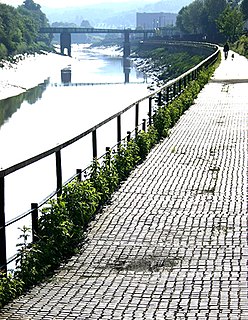
Bristol Harbour is the harbour in the city of Bristol, England. The harbour covers an area of 70 acres. It is the former natural tidal river Avon through the city but was made into its current form in 1809 when the tide was prevented from going out permanently. A tidal by-pass was dug for 2 miles through the fields of Bedminster for the river, known as the "River Avon New Cut", "New Cut", or simply "The Cut". It is often called the Floating Harbour as the water level remains constant and it is not affected by the state of the tide on the river in the Avon Gorge, The New Cut or the natural river southeast of Temple Meads to its source.

Bristol city centre Central Business District in England

Bristol City Centre is the commercial, cultural and business centre of Bristol, England. It is the area north of the New Cut of the River Avon, bounded by Clifton Wood and Clifton to the north-west, Kingsdown and Cotham to the north, and St Pauls, Lawrence Hill and St Phillip's Marsh to the east. The Bristol Royal Infirmary, Bristol Royal Hospital for Children, the BBC, the main campus of the University of Bristol, the Crown and Magistrate's Courts, Temple Meads railway station, Bristol bus station, the Park Street, Broadmead and Cabot Circus shopping areas together with numerous music venues, theatres and restaurants are located in this area. The area consists of the council wards of Central, Hotwells & Harbourside, and part of Lawrence Hill.

River Frome, Bristol River in south west England

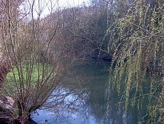
The Frome, historically the Froom, is a river that rises in Dodington Park, South Gloucestershire, and flows southwesterly through Bristol to join the river Avon. It is approximately 20 miles (32 km) long, and the mean flow at Frenchay is 60 cubic feet per second (1.7 m3/s). The name Frome is shared with several other rivers in South West England and means 'fair, fine, brisk'. The river is known locally in east Bristol as the Danny.

Spike Island, Bristol Human settlement in England

Spike Island is an inner city and harbour area of the English port city of Bristol, adjoining the city centre. It comprises the strip of land between the Floating Harbour to the north and the tidal New Cut of the River Avon to the south, from the dock entrance to the west to Bathurst Basin in the east. The island forms part of Cabot ward. The area between the Docks and New cut to the east of Bathurst Basin is in the neighbourhoods of Redcliffe and St Philip's Marsh.

Trams in Sydney

The Sydney tramway network served the inner suburbs of Sydney, Australia from 1879 until 1961. In its heyday, it was the largest in Australia, the second largest in the Commonwealth of Nations, and one of the largest in the world. The network was heavily worked, with about 1,600 cars in service at any one time at its peak during the 1930s . Patronage peaked in 1945 at 405 million passenger journeys. Its maximum street trackage totalled 291 km in 1923.

Bristol Tramways

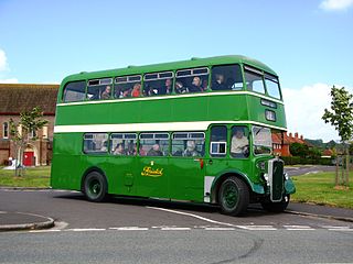
Bristol Tramways operated in the city of Bristol, England from 1875, when the Bristol Tramways Company was formed by Sir George White, until 1941 when a Luftwaffe bomb destroyed the main power supply cables.

Castle Park, Bristol

Castle Park is a public open space in Bristol, England, managed by Bristol City Council. It is bounded by the Floating Harbour and Castle Street to the south, Lower Castle Street to the east, and Broad Weir, Newgate and Wine Street to the north. Its western boundary is less obviously defined and has been the subject of controversy, perhaps because the area around High Street and St Mary le Port Church, though not part of the park and always intended for development, is often considered at the same time as the park.

Bristol Bridge Historic bridge in United Kingdom

Bristol Bridge is a bridge over the floating harbour in Bristol, England. The floating harbour was constructed on the original course of the River Avon, and there has been a bridge on the site since long before the harbour was created by impounding the river in 1809. The current bridge was completed in 1768 and is a Grade II listed building.

College Green, Bristol

College Green is a public open space in Bristol, England. The Green takes the form of a segment of a circle with its apex pointing east, and covers 1.1 hectares. The road named College Green forms the north-eastern boundary of the Green, Bristol Cathedral marks the south side, and City Hall closes the Green in an arc to the north-west.

Queen Square, Bristol

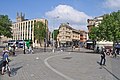
Queen Square is a 2.4 hectares Georgian square in the centre of Bristol, England. Following the 1831 riot, Queen Square declined through the latter part of the 19th century, was threatened with a main line railway station, but then bisected by a dual carriageway in the 1930s. By 1991 20,000 vehicles including scheduled buses were crossing the square every day, and over 30% of the buildings around it were vacant.

Reece Winstone FRPS (1909–1991) was an English photographer from Bristol. He edited and self-published the 'Bristol As It Was' books of photographs of Bristol, covering in detail the period from the dawn of photography to 1962.

St Mary on the Quay Church in Bristol, United Kingdom

St Mary on the Quay is a Roman Catholic Parish church in Bristol, England. It is situated on Colston Avenue, next to Colston Tower in the centre of the city. It is the oldest Roman Catholic church in Bristol; the first one built after the Reformation. it was formerly administered by the Society of Jesus and is currently served by the Divine Word Missionaries. It is a Grade II* listed building.

Sir George White, 1st Baronet (1854–1916), was an English businessman and stockbroker based in Bristol. He was instrumental in the construction of the Bristol tramways and became a pioneer in the construction of electric tramways in England. In 1910 he formed, with his brother Samuel, the Bristol Aeroplane Company. He had many other interests, particularly in transport companies.

Bristol Omnibus Company Defunct public transportation company based in Bristol, UK (1887-1987)

The Bristol Omnibus Company was a dominant bus operator in Bristol, and was one of the oldest bus companies in the United Kingdom. It ran buses over a wide area of Gloucestershire, Somerset, Wiltshire and neighbouring counties.

The Dutch House, Bristol Building in Bristol, England

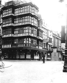
The Dutch House was a large timber-framed building situated at Nos 1 and 2, High Street Bristol, England. It was a well-known local landmark until its destruction in 1940.

Transport in Somerset Overview of transport in Somerset

The earliest known infrastructure for transport in Somerset is a series of wooden trackways laid across the Somerset Levels, an area of low-lying marshy ground. To the west of this district lies the Bristol Channel, while the other boundaries of the county of Somerset are along chains of hills that were once exploited for their mineral deposits. These natural features have all influenced the evolution of the transport network. Roads and railways either followed the hills, or needed causeways to cross the Levels. Harbours were developed, rivers improved, and linked to sources of traffic by canals. Railways were constructed throughout the area, influenced by the needs of the city of Bristol, which lies just to the north of Somerset, and to link the ports of the far south-west with the rest of England.

Buses in Bristol

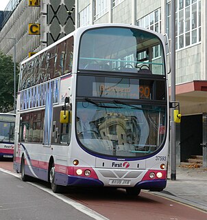
Buses are the main form of public transport in Bristol, England. Most bus services are operated by First West of England. Other companies offering services include Abus, Somerbus, Bristol Community Transport, Stagecoach West and Newport Bus.

Cardiff Corporation Tramways

Cardiff Corporation Tramways was a company that operated an electric tramway service in Cardiff between 1902 and 1950.

20th century road schemes in Bristol

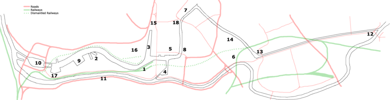
Road building was central to planning policy for much of the 20th century in Bristol, England. The planned road network evolved over time but at its core was a network of concentric ring roads and high-capacity radial roads.

Wine Street, Bristol Major street in Bristol, UK

Wine Street, together with High Street, Broad Street and Corn Street, is one of the four cross streets which met at the Bristol High Cross, the heart of Bristol, England when it was a walled mediaeval town. From this crossroads Wine Street runs along a level ridge approximately 175m north-eastwards to the top of Union Street.

References

  1. Insole & Porter 2016, p. 30-31.
  2. "Unofficial plaque calling Bristol capital of Atlantic slave trade removed from Edward Colston statue". Bristol Post. Archived from the original on 27 March 2018. Retrieved 26 March 2018.
  3. Insole & Porter 2016, p. 30.
  4. 1 2 Appleby 1969, p. 10.
  5. 1 2 "Bristol's Fascinating Fountains" (PDF). Temple Local History Group. p. 6. Archived (PDF) from the original on 21 July 2011. Retrieved 17 February 2011.
  6. Insole & Porter 2016, p. 19.
  7. "Bus Departure Information" (PDF). Bristol City Council. Retrieved 9 June 2018.
  8. "Ferry Map". Bristol Ferry Boat Co. Archived from the original on 8 July 2011. Retrieved 17 February 2011.
  9. 1 2 Winstone 1980, Plate 15.
  10. 1 2 Winstone, Reece (1972). Bristol as it Was 1956–1959. Reece Winstone. ISBN   0-900814-39-X.
  11. 1 2 3 Creating a new Centre for Bristol (leaflet), Bristol City Council, 1996
  12. 1 2 "New Bristol city centre road layout opens to traffic". BBC News. 2 April 2017. Archived from the original on 4 April 2017. Retrieved 13 April 2017.
  13. Insole & Porter 2016, p. 16.
  14. Little, Bryan (1991). The Story of Bristol From the Middle Ages to Today. Redcliffe Press Ltd. ISBN   1-872971-40-7.
  15. Winstone, Reece (1978). Bristol in the 1880s (2nd ed.). Reece Winstone. p. 23. ISBN   978-0-900814-55-6.
  16. Winstone, Reece (1973). Bristol in the 1890s. Reece Winstone. p. 9. ISBN   0-900814-42-X.
  17. 1 2 Winstone, Reece (1983). Bristol as it Was 1845–1900. Reece Winstone. ISBN   978-0-900814-00-6.
  18. Winstone, Reece (1979). Bristol as it Was 1928–1933. Reece Winstone. ISBN   0-900814-57-8.
  19. "Remembrance Day parades and services across greater Bristol area". Bristol Evening Post. Archived from the original on 18 December 2010. Retrieved 17 February 2011.
  20. Appleby et al. 1974, p. 90-92.
  21. Winstone, Reece (1977). Bristol in the 1920s. Reece Winstone. ISBN   0-900814-50-0.
  22. 1 2 "BT&CC tram map, 1911". Bristol Vintage Bus Group. Archived from the original on 23 July 2012. Retrieved 2 March 2011.
  23. Historic England. "Bristol Omnibus Company Travel and Chief Traffic Offices (1202525)". National Heritage List for England . Retrieved 9 June 2018.
  24. "Britain at War: Devastated by friend's death". Daily Telegraph. Archived from the original on 29 June 2011. Retrieved 20 February 2011.
  25. Priestley, J.B. (1934). English Journey. Mandarin. ISBN   978-0-7493-1924-3.
  26. Hulin 1974, p. 3.
  27. Hulin 1974, p. 4.
  28. Hulin 1974, p. 9.
  29. Appleby 1969, p. 65.
  30. Winstone, Reece (1978). Bristol as it Was 1939–1914 (5th ed.). Reece Winstone. ISBN   0-900814-54-3.
  31. Winstone 1980, Plate 124.
  32. Winstone 1980, Plate 12.
  33. City centre policy report and map 1966. City and County of Bristol. City of Bristol Printing and Stationery Department. 1966.
  34. 1 2 "Is it time to drive cars out of Bristol City Centre? Bristol's traffic supremo believes so". Bristol Evening Post. Archived from the original on 5 May 2013. Retrieved 19 February 2011.
  35. 1 2 "Bristol Central Area Action Plan: Cherish & Change summary". Bristol City Council. 26 July 2010. Archived from the original on 29 October 2010. Retrieved 19 February 2011.
  36. "Bristol centre to be revamped". BBC News. 15 May 2003. Archived from the original on 11 December 2003. Retrieved 18 February 2011.
  37. "Bristol city centre landmark has wind taken out of its sails". Bristol Evening Post. Archived from the original on 12 September 2012. Retrieved 19 February 2011.
  38. "City Centre Improvements". travelwest. Archived from the original on 26 March 2018. Retrieved 26 March 2018.
  39. Historic England. "Statue of Edmund Burke (1282140)". National Heritage List for England . Retrieved 18 April 2018.
  40. Historic England. "Statue of Edward Colston (1202137)". National Heritage List for England. Retrieved 18 April 2018.
  41. "Protesters begin fresh UK anti-racism demos". BBC News. 7 June 2020. Retrieved 7 June 2020.
  42. "Black Lives Matter protesters pull down statue of 17th century UK slave trader". The Independent. 7 June 2020. Retrieved 7 June 2020.
  43. Historic England. "Neptune Statue (1202528)". National Heritage List for England. Retrieved 18 April 2018.
  44. "Statues and Sculptures – Introduction". About Bristol. Retrieved 18 February 2011.
  45. "From eyesore to Bristol icon". Bristol Evening Post. Archived from the original on 21 April 2013. Retrieved 18 February 2011.
  46. "Broad Quay Serviced Apartments, Bristol". activehotels. Archived from the original on 7 July 2011. Retrieved 18 February 2011.
  47. Insole & Porter 2016, p. 6.

Sources

Bristolharbourmap.png

  1. Prince's Wharf, including M Shed, Pyronaut and Mayflower adjoining Prince Street Bridge
  2. Dry docks: SS Great Britain, the Matthew
  3. St Augustine's Reach, Pero's Bridge
  4. Bathurst Basin
  5. Queen Square
  6. Bristol Temple Meads railway station
  7. Castle Park
  8. Redcliffe Quay and Redcliffe Caves
  9. Baltic Wharf marina
  10. Cumberland Basin & Brunel Locks
  11. The New Cut
  12. Netham Lock, entrance to the Feeder Canal
  13. Totterdown Basin
  14. Temple Quay
  15. The Centre
  16. Canons Marsh, including Millennium Square and We The Curious
  17. Underfall Yard
  18. Bristol Bridge and Welsh Back