Eastville, Bristol

Last updated

Eastville
Bristol eastville.png
Boundaries of the city council ward.
Population12,455  [1]
OS grid reference ST613752
Unitary authority
Ceremonial county
Region
Country England
Sovereign state United Kingdom
Post town BRISTOL
Postcode district BS5
Dialling code 0117
Police Avon and Somerset
Fire Avon
Ambulance South Western
UK Parliament
List of places
UK
England
Bristol
51°28′30″N2°33′27″W / 51.4750°N 2.5574°W / 51.4750; -2.5574

Eastville is the name of both a council ward in the city of Bristol in the United Kingdom and a suburb of the city that lies within that ward. The Eastville ward covers the areas of Eastville, Crofts End (also known as Clay Hill), Stapleton and part of Fishponds. Notable places within the ward include Bristol Metropolitan Academy and Collegiate School, and the Bristol and Bath Railway Path also passes through the ward. [2]

Contents

Eastville

Eastville Park Eastville Park, south-west.jpg
Eastville Park

Eastville is an inner-suburb of the English city of Bristol, situated between Easton and Frome Vale wards in the north-east of the city. In the north-west its boundary is the M32 motorway, which roughly follows the River Frome.

Eastville Stadium (on the west bank of the Frome) used to be the home of Bristol Rovers Football Club, as well as being a site for greyhound racing and speedway, but this site has now been developed by IKEA.

Eastville Park is a large park with a small lake, just to the east of the M32. [3] [4] The lake at Eastville Park was instigated as part of a social scheme by Ernest Bevin (a well-respected westcountryman), who later became Minister of Labour under Churchill in the coalition government of WW2 and later Foreign Secretary in the Attlee Government from 1945 until his death.

A large railway viaduct known as 'The Thirteen Arches' for obvious reasons, once ran through the area, roughly parallel to the current Muller Road; it was demolished in 1968. [5] This was part of the Clifton Extension Railway.

The Eastville Workhouse, originally the Barton Regis Union Workhouse, [6] was a former French Prison which was bought from the Government circa 1832. [7] In 1930, the Stapleton Workhouse, originally the Bristol Union Workhouse, [6] became the Stapleton Institution and by the Second World War the site was mainly used for the care of the mentally ill and the elderly; eventually becoming Blackberry Hill Hospital.

Crofts End

Crofts End (also known as Clay Hill) is a suburb of Bristol. It is an industrialised area, with many small Victorian houses, built when this area was a coal mining community.

Churches

Crofts End Church was established in 1895 by George Brown, as a Christian work for miner's children in The Freestone Rank, Whitehall Road, it became known as The Miner's Mission. [8] It is now part of the local and much wider community but still very much a family church. The pastor is Andrew Yelland. [9]

The church was built on a site bounded by market gardens, a brick works and Deep Pit Colliery. When The Beaufort Arms, then known as The Beatem and Wackem and now called The Wackum Inn was the place where most miners spent their hard earned wages! Hence the need for a children's work in that community.

Another local church was Clay Hill Chapel which was demolished when the industrial estates were built.

Industry

In the 1920s the area consisted primarily of market gardens and a brick and tile works with a clay pit. [10] Over many years, the Market Gardens became housing, White's Brick Works became Somers Wood Yard (now an industrial pallet site) – and Deep Pit Colliery became industrial estates. When Deep Pit closed, men were having to walk underground as far as Frenchay to reach the coal face.

Housing

Crofts End House, located at the junction of Plummer's Hill and Whitehall Avenue, still exists, but no longer as a single dwelling. It has been refurbished and is now part of a housing association development.

The area is undergoing more change as the majority of 'prefabs' (built by American Service-men as post war housing) in the locality have been demolished. Planning applications will replace these with mixed style housing.

The old, redundant Civil Defence building on the junction of Crofts End Road and Brook Road was demolished and housing association flats were built on the site, now named "Craftes Court".

Fishponds

Fishponds is a predominantly residential area of Bristol that lies partially within the Eastville ward.

Stapleton

Stapleton is a suburb of Bristol which lies in the east of the city.

Residents

Related Research Articles

<span class="mw-page-title-main">M32 motorway</span> Motorway in England

The M32 is a 4.42 miles (7.11 km) long motorway in South Gloucestershire and Bristol, England. It provides a link from the M4, a major motorway linking London and South Wales, to Bristol city centre and is maintained by National Highways, the national roads body.

<span class="mw-page-title-main">River Frome, Bristol</span> River in south west England

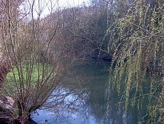
The Frome, historically the Froom, is a river that rises in Dodington Park, South Gloucestershire and flows southwesterly through Bristol to join the river Avon. It is approximately 20 miles (32 km) long, and the mean flow at Frenchay is 60 cubic feet per second (1.7 m3/s). The name Frome is shared with several other rivers in South West England and means 'fair, fine, brisk'. The river is known locally in east Bristol as the Danny.

St Pauls is an inner suburb of Bristol, England, situated just northeast of the city centre and west of the M32. It is bounded by the A38, the B4051, the A4032 and the A4044, although the River Frome was traditionally the eastern boundary before A4032 was constructed. St Pauls was laid out in the early 18th century as one of Bristol's first suburbs.

<span class="mw-page-title-main">Stapleton, Bristol</span> Human settlement in England

Stapleton is an area in the northeastern suburbs of the city of Bristol, England. The name is colloquially used today to describe the ribbon village along Bell Hill and Park Road in the Frome Valley. It borders Eastville to the South and Begbrook and Frenchay to the North. It comprises an eclectic mix of housing mainly from the Victorian, Edwardian, inter-war and late 20th century periods.

<span class="mw-page-title-main">Easton, Bristol</span> Human settlement in England

Easton is an inner city area of the city of Bristol in the United Kingdom. Informally the area is considered to stretch east of Bristol city centre and the M32 motorway, centred on Lawrence Hill. Its southern and eastern borders are less defined, merging into St Philip's Marsh and Eastville. The area includes the Lawrence Hill and Barton Hill estates.

Fishponds is a large suburb in the north-east of the English city of Bristol, about 3 miles (5 km) from the city centre. It has two large Victorian-era parks: Eastville Park and Vassall's Park. The River Frome runs through both with the Frome Valley Walkway alongside it. A restored mill found at Snuff Mills near the Vassall's Park end of the river has kept its original waterwheel, which can still be seen and heard turning. Eastville Park has a large boating lake with central wildlife reserves. Fishponds is mainly residential. Two main bus routes pass through. Housing is typically terraced Victorian. The high street shops include an international supermarket, Asian food store, charity shops, takeaways and Lidl, Aldi and Morrisons supermarkets. It has a small student population from the presence of the Glenside campus of the University of the West of England. The name Fishponds derives from when it was a quarry district, like nearby Soundwell. The empty quarries became large fishponds, which have since been filled in. One remained until the mid-1970s, when it was officially closed: a popular swimming area named "The Lido" by locals. It now belongs to an angling club.

<span class="mw-page-title-main">Ashley (Bristol ward)</span> Human settlement in England

Ashley is one of thirty-five council wards in the city of Bristol in the United Kingdom. The ward contains the areas of Baptist Mills, Montpelier, St Andrew's, St Paul's and St Werburgh's. The Ward has over 16,000 residents and is served by one community magazine and resident-led organisational body called 'Vocalise'.

<span class="mw-page-title-main">Eastville Stadium</span> Building in Bristol, England

<span class="mw-page-title-main">Whitehall, Bristol</span> Human settlement in England

Whitehall, is a district on the northeastern edge of central Bristol, within the electoral ward of Easton.

<span class="mw-page-title-main">Parks of Bristol</span>

The English city of Bristol has a number of parks and public open spaces.

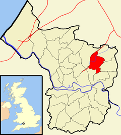
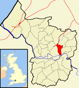
The city of Bristol, England, is divided into many areas, which often overlap or have non-fixed borders. These include Parliamentary constituencies, council wards and unofficial neighbourhoods. There are no civil parishes in Bristol.

Bristol North East was a borough constituency in the city of Bristol. It returned one Member of Parliament (MP) to the House of Commons of the Parliament of the United Kingdom.

Mayfield Park is a residential area in East Bristol, with a large adjoining park known as the Ridgeway Rd Playing Fields.

<span class="mw-page-title-main">Greenbank, Bristol</span> Human settlement in England

Greenbank is a small informal district in the city of Bristol, England nestling between Easton to the west, Eastville to the north-east, Clay Bottom and Rose Green to the east, and Whitehall to the south. The area is mainly one of 1890s terraced housing with some present millennium housing on the north eastern edge of the cemetery. Nearly all of the housing is in the north-east of Easton electoral ward, though the road Greenbank View and the cemetery are in Eastville electoral ward.

Brislington East is a council ward of the city of Bristol, England. The ward covers the eastern part of Brislington and the areas of Bristol known as Broom Hill, St Anne's and St Anne's Park.

<span class="mw-page-title-main">St Jude's, Bristol</span> Human settlement in England

St Jude's is a mixed residential, commercial and light industrial area of central Bristol, England. St Jude's forms part of the Lawrence Hill ward of Bristol City Council.

<span class="mw-page-title-main">Stapleton Road</span> Major thoroughfare in Bristol, England

Stapleton Road is a major thoroughfare in the English city of Bristol, running through the districts of Lawrence Hill and Easton. It is known for being very culturally diverse with many esoteric shops. However since the mid 20th century it has gained a reputation for having a high crime rate.

<span class="mw-page-title-main">Blackberry Hill Hospital</span> Hospital in Bristol, United Kingdom

Blackberry Hill Hospital is an NHS psychiatric hospital in Fishponds, Bristol, England, specialising in forensic mental health services, operated by the Avon and Wiltshire Mental Health Partnership NHS Trust. The hospital also offers drug and alcohol rehabilitation inpatient services, and is the base for a number of community mental health teams.

<span class="mw-page-title-main">Eastville Workhouse</span>

The Eastville Workhouse was a workhouse situated at 100 Fishponds Road, in Bristol, U.K. It was converted into a home for the elderly in the 1920s, and demolished to make way for housing in 1972.

References

  1. "Eastville" (PDF). 2011 Census Ward Information Sheet. Retrieved 26 February 2015.
  2. Bristol City Council. "Eastville ward map" (PDF). Archived from the original (PDF) on 3 August 2016. Retrieved 4 June 2016.
  3. "Factsheet – Eastville Park" (PDF). Avon Gardens Trust. Archived from the original (PDF) on 10 June 2004. Retrieved 19 March 2009.
  4. "Eastville Park, Bristol, England". Parks & Gardens UK. 27 July 2007. 1208. Retrieved 11 October 2017.
  5. Viaduct Demolished (Motion picture). British Pathe. 26 May 1968. 3311.14 / UN 4356 C. Retrieved 4 January 2016.
  6. 1 2 "Eastville And Stapleton Workhouses". Bristol Radical History Group. 10 February 2015. Retrieved 25 June 2015.
  7. "Bristol, Gloucestershire". The Workhouse. Retrieved 11 October 2015.
  8. "Miner-turned-preacher George dug deep for city". Western Daily Press. 28 July 2015. Retrieved 11 October 2015.[ permanent dead link ]
  9. "Crofts End Church" . Retrieved 25 October 2006.
  10. "Photograph: Clay Hill/Crofts End Brick and Tile Works. Greenbank Cemetery in top left. c. 1920s-1930s". Bristol Archives. Retrieved 13 August 2023.
  11. "Jack used to say his pigeons were his life". Exeter Express and Echo. 26 November 2011. Archived from the original on 23 September 2015. Retrieved 22 September 2015.