Kensington is an area of London in the Royal Borough of Kensington and Chelsea, around 2.9 miles (4.6 km) west of Central London.

The A4 is a major road in England from Central London to Avonmouth via Heathrow Airport, Reading, Bath and Bristol. It is historically known as the Bath Road with newer sections including the Great West Road and Portway. The road was once the main route from London to Bath, Bristol and the west of England and formed, after the A40, the second main western artery from London.
Knowle is a district and council ward in the south east of the city of Bristol in England, United Kingdom. It is bordered by Filwood Park to the west, Brislington to the east, Whitchurch and Hengrove to the south and Totterdown to the north. The settlement was mentioned in the Domesday Book as Canole. Knowle comes from the old English word for hillock, which means a little hill.

Hartcliffe is the name of both a council ward and an Outer Suburb of the city of Bristol in the United Kingdom which lies within that ward. The ward contains the areas of Hartcliffe and Headley Park, as well as small portions of Withywood and Bishopsworth.

Bedminster is a district of Bristol, England, on the south side of the city. It is also the name of a council ward which includes the central part of the district.
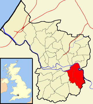
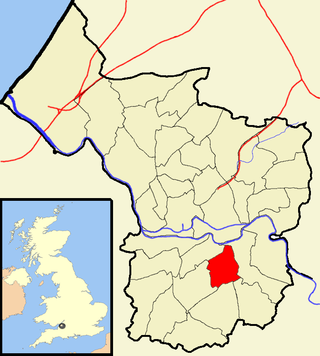
Brislington is an area in the south east of the city of Bristol, England. It is on the edge of Bristol and 10 miles (16 km) from Bath. Brislington Brook runs through the area in the woodlands of Nightingale Valley and St Anne's Wood. Brislington formerly housed the HTV West Studios on Bath Road, and this is situated next to the historic Arnos Vale Cemetery. Other notable landmarks include Brislington House and the 15th-century St Luke's Church. During the 18th–19th century, Brislington was regarded as a picturesque country village and contained many country homes.

Knowle West is a neighbourhood situated on a low plateau in the south of Bristol, England, about 2 miles (3 km) from the centre of the city. Historically in Somerset, most of the area is coterminous with the Filwood ward of Bristol City Council, although a small part of the estate lies within Knowle ward to the east. To the west are Bishopsworth and Hartcliffe. To the north are Bedminster and Windmill Hill and to the south Whitchurch Park and Hengrove. In 2008 the population was estimated to be 11,787. The area is approximately 1.26 square miles (3.3 km2).
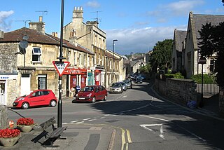
Weston is a suburb and electoral ward of Bath in Bath and North East Somerset, South West England, located in the northwest of the city. Originally a separate village, Weston has become part of Bath as the city has grown, first through the development of Lower Weston in Victorian times and then by the incorporation of the village into the city, with the siting of much local authority housing there in the period after World War II.

The English city of Bristol has a number of parks and public open spaces.
The city of Bristol, England, is divided into many areas, which often overlap or have non-fixed borders. These include Parliamentary constituencies, council wards and unofficial neighbourhoods. There are no civil parishes in Bristol.

Arnos Vale Cemetery, in Arnos Vale, Bristol, England, was established in 1837. Its first burial was in 1839. The cemetery followed a joint-stock model, funded by shareholders. It was laid out as an Arcadian landscape with buildings by Charles Underwood. Most of its area is listed, Grade II*, on the Register of Historic Parks and Gardens of special historic interest in England.
James Bridges was an English architect and civil engineer working in Bristol between 1757 and 1763. He designed Royal Fort House (1760), rebuilt St Werburgh's Church (1758–61) and began the rebuilding of both Bristol Bridge and St Nicholas' Church.

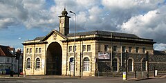
Black Castle Public House is a Grade I-listed building and public house on Junction Road in the Brislington suburb of the English city of Bristol. It is also known as Arno's Castle.
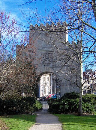
Arnos Court Triumphal Arch is an 18th-century monument in Junction Road, Brislington, Bristol, England.
Brislington East is a council ward of the city of Bristol, in the United Kingdom. The ward covers the eastern part of Brislington and the areas of Bristol known as Broom Hill, St Anne's and St Anne's Park.

Brislington Brook is a short, 5 miles (8.0 km) long tributary of the Bristol Avon, rising on the northern slopes of Maes Knoll on the southern boundary of the city of Bristol, England. The stream has been badly affected by pollution but improvements have been made in the latter part of the twentieth century, and some wildlife is supported. St Anne's Well near the northern end of the brook was a major pilgrimage site for Christians in the Middle Ages.
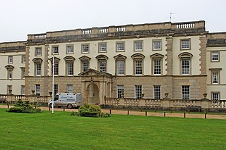
Brislington House was built as a private lunatic asylum. When it opened in 1806 it was one of the first purpose-built asylums in England. It is situated on the Bath Road in Brislington, Bristol, although parts of the grounds cross the city boundary into the parish of Keynsham in Bath and North East Somerset.
South Bristol is the part of Bristol, England south of the Bristol Avon. It is almost entirely made up of the areas of the city historically in Somerset, and since the abolition of the county Avon, consists of the southern suburbs in the county of Bristol. Definitions sometimes also include areas of North Somerset, including Long Ashton, Nailsea and Backwell.