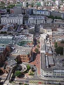
Broadmead

Last updated

Part of Broadmead Shopping Centre Bristol.broadmead.balloon.arp.jpg
Part of Broadmead Shopping Centre

Broadmead is a street in the central area of Bristol, England, which has given its name to the principal shopping district of the city. It is part of Bristol Shopping Quarter.

Contents

History

The Arcade, built in 1825 Bristol - The Arcade.jpg
The Arcade, built in 1825

The name of the street was first recorded in 1383 as Brodemede. The name either means "broad meadow" or refers to brodemedes, a type of woollen cloth woven only in Bristol. [1]

The area lay just to the north of the town walls of the historic Bristol. In about 1227 Blackfriars was founded as a Dominican priory in the area. After the dissolution of the monasteries the site had various secular uses, and in 1749 became the location of a Quaker meeting house, now known as Quakers Friars. In 1671 local dissenters opened the Broadmead Baptist Chapel near the junction of Broadmead and Union Street. In 1739 John Wesley built his Methodist chapel, known as the New Room, in the street. Shops were also built in the area. In 1825 a covered arcade was built between Horsefair and Broadmead, which still survives and is the second oldest building in Broadmead. Originally accompanied by another section, the Upper Arcade, but that was destroyed by 1940 bombing. [2] [3] St James' Priory, founded 1129, is northwest of Broadmead and Castle Park, the site of the Norman Bristol Castle, is to the south.

When the old shopping district of Castle Street and Wine Street was heavily damaged in the Bristol Blitz, it was decided to redevelop the Broadmead area as the main shopping district of the city. [4] Rebuilding began in 1950. The existing street, which ran between Union Street and Merchant Street, was extended north to include the former Rosemary Street. [5] Like most 1950s buildings in Britain, affordable and architecturally uninteresting utilitarian buildings form the bulk of the Broadmead area. In the 1980s some of these were removed to make way for the Galleries shopping centre, which is a three level covered street. Broadmead and several of the surrounding streets were pedestrianised.

Broadmead today

North-east entrance to The Galleries The Galleries Shopping Centre.JPG
North-east entrance to The Galleries

A regeneration project for Broadmead finished about 2010. The shopping area has been extended over the central ring road to produce a new shopping centre, Cabot Circus, which opened in September 2008. This area had been named Merchants Quarter but in April 2006 the name was abandoned after a campaign claiming the name was offensive because it was the Bristol Merchant Venturers who dealt in the trade of African slaves.

In 1987, the shopping centre was the scene of an abduction that received national attention. On 8 October 1987, 29-year-old newly-wed Shirley Banks was abducted by serial killer John Cannan as she walked back to her car. [6] Her body was found on Easter Day 1988. Cannan was convicted of her abduction and murder.

A business improvement district (BID) was established for Broadmead in 2005, with a current plan that extends to 2028. [7]

In 2021, flagship shop Debenhams closed following the chain's bankruptcy, and the closure of the Marks & Spencer branch was announced for January 2022. [8]

Public Transport

Broadmead is served by various bus services and is immediately south of Bristol bus station. Bristol Temple Meads station is about half a mile south east.

Related Research Articles

<span class="mw-page-title-main">Cardiff city centre</span> Central Business District in Wales

Cardiff city centre is the city centre and central business district of Cardiff, Wales. The area is tightly bound by the River Taff to the west, the Civic Centre to the north and railway lines and two railway stations – Central and Queen Street – to the south and east respectively. Cardiff became a city in 1905.

<span class="mw-page-title-main">Bristol City Centre</span> Central Business District in England

Bristol City Centre is the commercial, cultural and business centre of Bristol, England. It is the area north of the New Cut of the River Avon, bounded by Clifton Wood and Clifton to the north-west, Kingsdown and Cotham to the north, and St Pauls, Lawrence Hill and St Phillip's Marsh to the east. The Bristol Royal Infirmary, Bristol Royal Hospital for Children, the BBC, the main campus of the University of Bristol, the Crown and Magistrate's Courts, Temple Meads railway station, Bristol bus station, the Park Street, Broadmead and Cabot Circus shopping areas together with numerous music venues, theatres and restaurants are located in this area. The area consists of the council wards of Central, Hotwells & Harbourside, and part of Lawrence Hill.

<span class="mw-page-title-main">Allders</span> British department store

Allders was an independent department store operating in the United Kingdom.

<span class="mw-page-title-main">Buildings and architecture of Bristol</span>

Bristol, the largest city in South West England, has an eclectic combination of architectural styles, ranging from the medieval to 20th century brutalism and beyond. During the mid-19th century, Bristol Byzantine, an architectural style unique to the city, was developed, and several examples have survived.

Swansea city centre in Swansea, Wales, contains the main shopping, leisure and nightlife district in Swansea. The city centre covers much of the Castle ward including the area around Oxford Street, Castle Square, and the Quadrant Shopping Centre; Alexandra Road, High Street, Wind Street and the Castle; Parc Tawe; and the Maritime Quarter extending down to the seafront.

<span class="mw-page-title-main">St James' Priory, Bristol</span> Church in England

The Priory Church of St James, Bristol, is a Grade I listed building in Horsefair, Whitson Street.

<span class="mw-page-title-main">Briggate</span>

Briggate is a pedestrianised principal shopping street in Leeds city centre, England. Historically it was the main street, leading north from Leeds Bridge, and housed markets, merchant's houses and other business premises. It contains many historic buildings, including the oldest in the city, and others from the 19th and early-20th century, including two theatres. It is noted for the yards between some older buildings with alleyways giving access and Victorian shopping arcades, which were restored in late 20th century. The street was pedestrianised in the late-20th century.

<span class="mw-page-title-main">Parks of Bristol</span>

The English city of Bristol has a number of parks and public open spaces.

<span class="mw-page-title-main">Castle Park, Bristol</span>

Castle Park is a public open space in Bristol, England, managed by Bristol City Council. It is bounded by the Floating Harbour and Castle Street to the south, Lower Castle Street to the east, and Broad Weir, Newgate and Wine Street to the north. Its western boundary is less obviously defined and has been the subject of controversy, perhaps because the area around High Street and St Mary le Port Church, though not part of the park and always intended for development, is often considered at the same time as the park.

<span class="mw-page-title-main">St David's, Cardiff</span> Shopping centre in Cardiff, Wales

St David's, previously known as St David's Shopping Centre, is one of the principal shopping centres in the city centre of Cardiff, Wales. It is in The Hayes area of the southern city centre. Following the extension of St David's 2 in 2009, St David's is the third busiest shopping centre in the United Kingdom.

Southampton City Centre is the commercial and organisational centre of the City of Southampton, and the transport hub of the city. Because Southampton is on the South Coast of England, the city centre is not at the geometric centre of the city, but at the southern extremity.

<span class="mw-page-title-main">Quakers Friars</span> Building in Bristol, England

Quakers Friars is a Grade 1 Listed building in Broadmead, Bristol. Part of the former Blackfriars Priory site, it was used as a Quaker meeting house for nearly three hundred years, more recently serving as a registry office, a theatre, and a series of restaurants. It is an important site in both the early history of the Dominican Order in England and of the Religious Society of Friends (Quakers).

<span class="mw-page-title-main">Old Market, Bristol</span> Building in Bristol, England

Old Market is a Conservation Area of national significance, to the east of the city centre in Bristol, England. Old Market Street and West Street form the central axis of the area, which is approximately bounded by New Street and Lawfords Gate to the north, Trinity Road and Trinity Street to the east, Unity Street and Waterloo Road to the south and Temple Way Underpass to the west.

<span class="mw-page-title-main">The Hayes</span> Area and street in Cardiff, Wales

The Hayes is a commercial area in the southern city centre of the Welsh capital, Cardiff. Centred on the road of that name leading south towards the east end of the city centre, the area is mostly pedestrianised and is the location of the Hayes Island Snack Bar.

<span class="mw-page-title-main">Cabot Circus</span> Shopping mall in Bristol, England

Cabot Circus is a covered shopping centre in Bristol, England. It is adjacent to Broadmead, a shopping district in Bristol city centre. The Cabot Circus development area contains shops, offices, a hotel, 250 apartments and formerly, a cinema. It covers a total of 139,350 m2 (1,500,000 sq ft) floor space, of which 92,900 m2 (1,000,000 sq ft) is retail outlets and leisure facilities. It opened in September 2008, after a ten-year planning and building project costing £500 million.

<span class="mw-page-title-main">Blackfriars, Bristol</span> Building in Bristol, England

Blackfriars, Bristol was a Dominican priory in Broadmead, Bristol, England. It was founded by Maurice de Gaunt in 1227 or 1228. Llywelyn ap Dafydd, son of Dafydd ap Gruffydd, the last native Prince of Wales, was buried in the cemetery of the priory. Following the Dissolution of the Monasteries in the 16th century, surviving parts of the priory became a guildhall for the Smiths and Cutlers Company, the Bakers Company, a workhouse and then Bristol Quaker meeting house. In the 20th century, it has housed the local register office, a theatre company, and a restaurant.

The Mander Centre is a major shopping centre in Wolverhampton City Centre, in Wolverhampton, England, developed by Manders Holdings Plc, the paint, inks and property conglomerate, between 1968 and 1974. The site occupies four and a half acres comprising the old Georgian works and offices of the Mander family firm, founded in 1773, as well as the site of the former Queens Arcade, which had stood on the site since 1902.

<span class="mw-page-title-main">High Street, Bristol</span> Street in central Bristol, England

High Street, together with Wine Street, Broad Street and Corn Street, is one of the four cross streets which met at the carfax, later the site of the Bristol High Cross, the heart of Bristol, England when it was a walled medieval town. From this crossroads High Street runs downhill south-east to Bristol Bridge, a distance of approximately 155m.

<span class="mw-page-title-main">Wine Street, Bristol</span> Major street in Bristol, UK

Wine Street, together with High Street, Broad Street and Corn Street, is one of the four cross streets which met at the Bristol High Cross, the heart of Bristol, England when it was a walled mediaeval town. From this crossroads Wine Street runs along a level ridge approximately 175m north-eastwards to the top of Union Street.

References

  1. Smith, V. (2002), Street Names of Bristol, Broadcast Books, ISBN   1-874092-90-7.
  2. "Revisit the History of the Bristol Arcade!". The Arcade, Broadmead. 10 June 2022. Retrieved 27 March 2024.
  3. Historic England. "Lower Arcade (Grade II) (1202024)". National Heritage List for England .
  4. Jenner, Mike (2000). "The Origins of the Broadmead Shopping Centre". Post-War Bristol 1945-1965: Twenty years that changed the city. Bristol: Bristol Historical Association. pp. 9–24.
  5. Reece Winstone (1967) Bristol Today photos 101ff
  6. "Casebook: Monster John Cannan murdered newly wed". Birmingham Mail. 2 May 2011. Archived from the original on 30 December 2010. Retrieved 11 February 2011.
  7. "Business Plan 2018 – 2023" (PDF). Broadmead BID. 2018. Retrieved 10 November 2021.
  8. Taylor, Mark (10 November 2021). "What next for Bristol shopping district Broadmead after M&S and Debenhams closures?". Bristol Post. Retrieved 10 November 2021.

51°27′25″N2°35′17″W / 51.457°N 2.588°W / 51.457; -2.588