
Keynsham is a town and civil parish located between Bristol and Bath in Somerset, England. It has a population of 16,000. It was listed in the Domesday Book as Cainesham, which is believed to mean the home of Saint Keyne.

Patchway is a suburban town in South Gloucestershire, England, situated 10 km (6.2 mi) north-north west of central Bristol. The town is a housing overflow for Bristol being contiguous to Bristol's urban area, and is often regarded as a large outer suburb. Nearby are the other Bristol satellite towns of Filton and Bradley Stoke. Patchway is twinned with Clermont l'Herault, France, and Gauting, Germany. It was established as a civil parish in 1953, becoming separate from the parish of nearby Almondsbury.
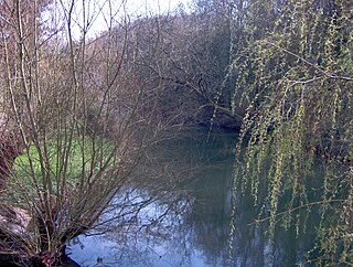
The Frome, historically the Froom, is a river that rises in Dodington Park, South Gloucestershire, and flows southwesterly through Bristol, joining the former course of the river Avon in Bristol's Floating Harbour. It is approximately 20 miles (32 km) long, and the mean flow at Frenchay is 60 cubic feet per second (1.7 m3/s). The name Frome is shared with several other rivers in South West England and means 'fair, fine, brisk'. The river is known locally in east Bristol as the Danny.

Stapleton is an area in the northeastern suburbs of the city of Bristol, England. The name is colloquially used today to describe the ribbon village along Bell Hill and Park Road in the Frome Valley. It borders Eastville to the South and Begbrook and Frenchay to the North. It comprises an eclectic mix of housing mainly from the Victorian, Edwardian, inter-war and late 20th century periods.

Bedminster is a district of Bristol, England, on the south side of the city. It is also the name of a council ward, which includes the central part of the district and some other areas.
South Croydon in south London is the area surrounding the valley south of central Croydon and running as far south as the former Red Deer public house on the Brighton Road. It is bounded by Waddon to the West and Selsdon and Sanderstead to the East. It is part of the South Croydon (CR2) post town and in the London Borough of Croydon. It is essentially a dormitory suburb for Croydon and London.

Fishponds is a large suburb in the north-east of the English city of Bristol, about 3 miles (5 km) from the city centre. It has two large Victorian-era parks: Eastville Park and Vassall's Park. The River Frome runs through both with the Frome Valley Walkway alongside it. A restored mill found at Snuff Mills near the Vassall's Park end of the river has kept its original waterwheel, which can still be seen and heard turning. Eastville Park has a large boating lake with central wildlife reserves. Fishponds is mainly residential. Two main bus routes pass through. Housing is typically terraced Victorian. The high street shops include an international supermarket, Asian food store, charity shops, takeaways and Lidl, Aldi and Morrisons supermarkets. It has a small student population from the presence of the Glenside campus of the University of the West of England. The name Fishponds derives from when it was a quarry district, like nearby Soundwell. The empty quarries became large fishponds, which have since been filled in. One remained until the mid-1970s, when it was officially closed: a popular swimming area named "The Lido" by locals. It now belongs to an angling club.

The River Trym is a short river, some 4.5 miles (7.2 km) in length, which rises in Filton, South Gloucestershire, England. The upper reaches are culverted, some underground, through mostly urban landscapes, but once it emerges into the open it flows through a nature reserve and city parks before joining the tidal River Avon at Sea Mills. 18th-century water mills near the mouth gave the area its name.

Eastville is the name of both a council ward in the city of Bristol in the United Kingdom and a suburb of the city that lies within that ward. The Eastville ward covers the areas of Eastville, Crofts End, Stapleton and part of Fishponds. Notable places within the ward include Bristol Metropolitan College and Colston's School, and the Bristol and Bath Railway Path also passes through the ward.

Walton in Gordano is a village and civil parish in North Somerset, England. It is situated in a small valley at the side of the south-western end of the Gordano Valley, about a mile from Clevedon. The parish has a population of 273.

Churchill is a village and civil parish in Somerset, England. It is located in the unitary authority of North Somerset, on the western edge of the Mendip Hills, about 8 miles (12.9 km) east of Weston-super-Mare, and about 15 miles (24.1 km) south-west of Bristol. The parish, which includes the village of Lower Langford and the hamlet of Upper Langford, has a population of 2,250.

Compton Martin is a small village and civil parish within the Chew Valley in Somerset and in the Bath and North East Somerset unitary authority in England. The parish has a population of 508. It lies between Chew Valley Lake and Blagdon Lake, north of the Mendip Hills, approximately 10 miles (16 km) south of Bristol on the A368 road Weston-super-Mare to Bath, between Blagdon and West Harptree.
Whitehall, is a district on the northeastern edge of central Bristol, within the electoral ward of Easton.

Coombe Dingle is a suburb of Bristol, England, centred near where the Hazel Brook tributary of the River Trym emerges from a limestone gorge bisecting the Blaise Castle Estate to join the main course of the Trym. Historically this area formed part of the parish of Westbury on Trym, Gloucestershire, and is now part of Kingsweston ward of the city of Bristol. South of Coombe Dingle is Sea Mills; to the north is Kings Weston Hill; to the west are Kings Weston House and Shirehampton Park; and to the east, Henbury Golf Club and Westbury on Trym proper.
The city of Bristol is divided into many areas, which often overlap or have non-fixed borders. These include Parliamentary constituencies, council wards and unofficial neighbourhoods. There are no civil parishes in Bristol.
Hillfields is an area and ward of north-east Bristol.
Kingsweston is a ward of the city of Bristol. The three districts in the ward are Coombe Dingle, Lawrence Weston and Sea Mills. The ward takes its name from the old district of Kings Weston, now generally considered part of Lawrence Weston.

Lodge Causeway is an ancient passage through the former Royal Forest of Kingswood and now the main road between Fishponds and Kingswood in Bristol, England. The road is designated the B4048.
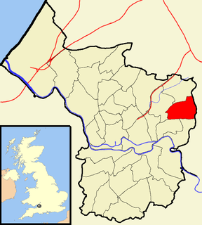
Lodge Hill is a hill and residential area of Bristol, England. It is in the electoral ward of Hillfields, Bristol, separating the large outer urban areas of Fishponds and Kingswood. Cossham Memorial Hospital is at its peak which is the highest point in urban Bristol at 369 ft. It has a population of 1,722 (est).

Long Causeway or Long Causey was a Medieval packhorse route in England, which ran between Sheffield in South Yorkshire and Hathersage in Derbyshire. In the past the route has been marked on maps as a Roman Road as it was believed it followed part of the route of Batham Gate between Templeborough and Buxton, although in recent years some scholars have cast doubt on this.


