
Bristol Temple Meads is the oldest and largest railway station in Bristol, England. It is located 118 miles 31 chains away from London Paddington. It is an important transport hub for public transport in the city; there are bus services to many parts of the city and surrounding districts, with a ferry to the city centre. Bristol's other major station, Bristol Parkway, is a more recent station on the northern outskirts of the conurbation.

Staple Hill is a suburb of Bristol, England, lying outside the city boundary in South Gloucestershire, in the ceremonial county of Gloucestershire. It is directly east of Fishponds, south of Downend, west of Mangotsfield and north of Soundwell.
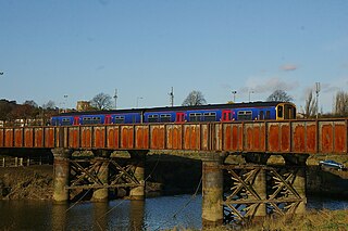
The Severn Beach line is a local railway line in Bristol and Gloucestershire, England, which runs from Bristol Temple Meads to Severn Beach, and used to extend to Pilning. The first sections of the line were opened in 1863 as part of the Bristol Port Railway and Pier; the section through Bristol was opened in 1875 as the Clifton Extension Railway.
Easton is an inner city area of the city of Bristol in the United Kingdom. Informally the area is considered to stretch east of Bristol city centre and the M32 motorway, centred on Lawrence Hill. Its southern and eastern borders are less defined, merging into St Philip's Marsh and Eastville. The area includes the Lawrence Hill and Barton Hill estates.

Stapleton Road railway station is on the Severn Beach Line and Cross Country Route, serving the inner-city district of Easton in Bristol, England. It is 1.6 miles (2.6 km) from Bristol Temple Meads. Its three letter station code is SRD. The station has two platforms, four running lines and minimal facilities. It is managed by Great Western Railway, the seventh company to be responsible for the station, and the third franchise since privatisation in 1997. They provide all train services at the station, the standard service being two trains per hour along the Severn Beach Line and an hourly service between Bristol Temple Meads and Filton Abbey Wood.

Spike Island is an inner city and harbour area of the English port city of Bristol, adjoining the city centre. It comprises the strip of land between the Floating Harbour to the north and the tidal New Cut of the River Avon to the south, from the dock entrance to the west to Bathurst Basin in the east. The island forms part of Cabot ward. The area between the Docks and New cut to the east of Bathurst Basin is in the neighbourhoods of Redcliffe and St Philip's Marsh.
Oldland Common is a village in the far south region of South Gloucestershire, England, on the outskirts of Bristol. It is in the civil parish of Bitton, approximately 8 miles between the centres of cities Bristol and Bath.

Cabot was a council ward that covered the centre of Bristol, England. It took its name from the Cabot Tower, a memorial tower on Brandon Hill that was built to commemorate John Cabot's voyage and "discovery" of North America. The ward was abolished in 2016.

Redfield is an area situated in East Bristol though it is represented in Westminster as part of the Bristol West constituency. It includes the stretch of Church Road (A420) from Verrier Road to the western boundary of St George's Park, Victorian-era landscaped parkland. It is adjacent to the neighbourhoods of Barton Hill and Russell Town to the South, St George to the East, Whitehall to the North and Lawrence Hill to the West and Pile Marsh to the South-East.
Bristol is a city in south west England, near the Bristol Channel coast, approximately 106 miles (170 km) west of London. Several factors have influenced the development of its transport network. It is a major centre of employment, retail, culture and higher education, has many historic areas, and has a history of maritime industry. The city has a population of 450,000, with a metropolitan area of 650,000, and lies at the centre of the former County of Avon, which includes many dormitory towns, and has a population of one million.

Lawrence Hill railway station is on the Severn Beach Line and Cross Country Route, serving the inner-city districts of Easton and Lawrence Hill in Bristol, England. It is 1.0 mile (1.6 km) from Bristol Temple Meads. Its three letter station code is LWH. The station has two platforms, four running lines and minimal facilities. It is managed by Great Western Railway, the seventh company to be responsible for the station and the third franchise since privatisation in 1997. They provide all train services at the station, the standard service being two trains per hour along the Severn Beach Line and an hourly service between Bristol Temple Meads and Filton Abbey Wood.
Redcliffe, also known as Redcliff, is a district of the English port city of Bristol, lying south-east of the city centre. It is bounded by the loop of the Floating Harbour to the west, north and east, together with the New Cut of the River Avon to the south. Most of Redcliffe lies within the city ward of Lawrence Hill, although the westernmost section, including the cliffs and hill from which the area takes its name, is in Cabot ward. Bristol Temple Meads station is located in Redcliffe.

Bedminster railway station is on the Bristol to Exeter line and serves the districts of Bedminster and Windmill Hill in Bristol, south-west England. It is 0.9 miles (1.4 km) to the west of Bristol Temple Meads, and 119 miles (192 km) from London Paddington. Its three letter station code is BMT. It was opened in 1871 by the Bristol and Exeter Railway, was resited slightly further to the west in 1884 and was rebuilt in 1932. The station, which has three through-lines and two island platforms, but minimal facilities, is managed by Great Western Railway who operates all train services that serve the station, mainly an hourly service between Bristol Parkway and Weston-super-Mare.

Newbridge is a largely residential electoral ward on the western edge of Bath, Somerset, England.
The majority of public transport users in the Bristol Urban Area are transported by bus, although rail has experienced growth and does play an important part, particularly in peak hours. There were plans for a light rail system, however this has now been dropped although it remains in the long-term local transport plan.

Greenbank is a small informal district in the city of Bristol, England nestling between Easton to the west, Eastville to the north-east, Clay Bottom and Rose Green to the east, and Whitehall to the south. The area is mainly one of 1890s terraced housing with some present millennium housing on the north eastern edge of the cemetery. Nearly all of the housing is in the north-east of Easton electoral ward, though the road Greenbank View and the cemetery are in Eastville electoral ward.
Rail services in the West of England refer to passenger rail journeys made in the Bristol commuter area. 17 million passenger rail journeys were made in 2019-20 within the Gloucestershire, Wiltshire and Bristol/Bath region.
Kingsweston was a ward of the city of Bristol. The three districts in the ward wer Coombe Dingle, Lawrence Weston and Sea Mills. The ward takes its name from the old district of Kings Weston, now generally considered part of Lawrence Weston. Following a Local Government Boundary Commission review in 2015 ward boundaries were redrawn and Kingsweston ward is now split between the Stoke Bishop ward and the Avonmouth and Lawrence Weston ward.
South Bristol is the part of Bristol, England south of the Bristol Avon. It is almost entirely made up of the areas of the city historically in Somerset, and since the abolition of the county Avon, consists of the southern suburbs in the county of Bristol. Definitions sometimes also include areas of North Somerset, including Long Ashton, Nailsea and Backwell.
The city of Bristol in the United Kingdom has included a light rail transport system in its plans from the 1980s onwards. There has been no light rail in the city since the closure of Bristol Tramways in 1941.

