Related Research Articles

South Tawton is a village, parish and former manor on the north edge of Dartmoor, Devon, England. An electoral ward bearing the same name exists. At the 2011 census the population was 1,683.

The River Taw rises at Taw Head, a spring on the central northern flanks of Dartmoor, crosses North Devon and at the town of Barnstaple, formerly a significant port, empties into Bideford Bay in the Bristol Channel, having formed a large estuary of wide meanders which at its western end is the estuary of the River Torridge.

North Devon is a constituency represented in the House of Commons of the UK Parliament since 2019 by Selaine Saxby of the Conservative Party.
Winkleigh is a civil parish and small village in Devon, England. It is part of the local government area of Torridge District Council. The population of the parish at the 2011 census was 1,305, compared to 1,079 in 1901. The population of the electoral ward in 2011 was 2,068.

Bishop's Tawton is a village and civil parish in the North Devon district of Devon, England. It is in the valley of the River Taw, about three miles south of Barnstaple. According to the 2001 census the parish had a population of 1,176.
Bow is a village and civil parish in the Mid Devon district of Devon, England, about 8 miles (13 km) west of Crediton. According to the 2001 census it had a population of 1,093 practically unchanged at the 2011 Census. There is an adjoining hamlet of Nymet Tracey which shares a church with Bow and much common history. Bow is a major part of Upper Yeo electoral ward. The total ward population at the above census was 1,708.

North Tawton is a small town in Devon, England, situated on the river Taw. It is administered by West Devon Council. The population of the electoral ward at the census 2011 was 2,026.
The EX postcode area, also known as the Exeter postcode area, is a group of 33 postcode districts in South West England, within 30 post towns. These cover north and east Devon, plus the northernmost part of Cornwall and very small parts of Somerset and Dorset.
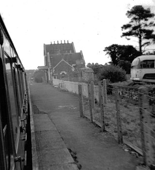
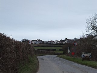
Bow railway station was a railway station serving the village of Bow and the hamlet of Nymet Tracy in Devon. Bow lies about 8 miles west of Crediton.
Nymet Rowland is a small village, and civil parish of the same name, in central Devon, England, north of Dartmoor. It takes part of its name from "Nymet", the old name for the nearby River Yeo. It is located just to the west of Lapford and south of Nymet Bridge, within the Mid Devon local authority area. Historically it formed part of Winkleigh Hundred; today the North Tawton hundred. It falls within the Cadbury Deanery for ecclesiastical purposes.
King's Nympton is a village, parish and former manor in the North Devon district, in Devon, England, in the heart of the rolling countryside between Exmoor and Dartmoor, some 4½ miles (7 km) S.S.W. of South Molton and 4 miles (6 km) N. of Chulmleigh. The parish exceeds 5,500 acres (2,226 ha) in area and sits mostly on a promontory above the River Mole which forms nearly half of its parish boundary. In 2021 the parish had a population of 444.
South Molton Hundred was the name of one of thirty two ancient administrative units of Devon, England.

George Nympton or Nymet St George is a small village and civil parish in North Devon district, Devon, England. In the 2011 census it was recorded as having a population of 175.
Ansger of Montacute was one of the Devon Domesday Book tenants-in-chief of King William the Conqueror.

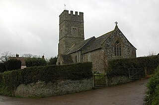
The Church of St John the Baptist is the Anglican parish church for the village of Bishop's Tawton in Devon. The church has been a Grade I listed building since 1965 and comes under the Diocese of Exeter.

North Tawton Town Hall is a municipal building in The Square, North Tawton, Devon, England. The town hall, which is used for public events, is a Grade II listed building.

Honeychurch is a village and former civil parish now in the parish of Sampford Courtenay, in the West Devon district of the English county of Devon. It was originally an ancient parish in the Black Torrington hundred of northwest Devon.
References
- 1 2 "THE HUNDREDS OF DEVON". GENUKI. Retrieved 8 April 2018.
| | This Devon location article is a stub. You can help Wikipedia by expanding it. |