Northern California megaregion

Last updated
Northern California megaregion
San Francisco from Twin Peaks September 2013 panorama 5 edit.jpg
California State Capitol from Capitol Mall - Sacramento (26429122855).jpg
Downtown San Jose (30001966530).jpg
Tribune Tower in Downtown Oakland, Jan 2009, by Hitchster.jpg
CA State Route 237 aerial (cropped).jpg
Northern California megaregion
Interactive Map of the
Northern California Megaregion
Country Flag of United States.svg United States
State Flag of California.svg California
Largest cities San Jose (1,035,317)
San Francisco (884,363)
Sacramento (501,901)
Oakland (425,195)
Area
  Land60,010 km2 (23,171 sq mi)
Population
 (2017)
  Total12,594,831
  Density209.9/km2 (543.6/sq mi)
GDP
  Total$1.536 trillion (2022)

The Northern California megaregion (also Northern California Megalopolis), distinct from Northern California, is an urbanized region of California consisting of many large cities including San Jose, San Francisco, Sacramento, and Oakland. There are varying definitions of the megaregion, but it is generally seen as encompassing the San Francisco Bay Area, the Sacramento area, northern San Joaquin Valley, and the Monterey Bay Area. [2]

Contents

The most common definition of the megaregion consists of the San Jose–San Francisco–Oakland Combined Statistical Area, the Sacramento–Roseville–Arden-Arcade Metropolitan Statistical Area, the Yuba City Metropolitan Statistical Area, the Modesto Metropolitan Statistical Area, the Merced Metropolitan Statistical Area, and the Salinas Metropolitan Area. [3] [4] [5] Under this definition, the megaregion was home to 12.6 million residents in 2018, [6] and had a GDP of $1.21 trillion, [7] resulting in a GDP per capita of $96,029. The megaregion thus accounted for 3.9% of the U.S. population, [6] and 5.9% of the U.S. economy in 2018. [8]

The concept is seen as increasingly relevant in the context of a rapidly growing Northern California economy plagued by transportation issues and a lack of affordable housing. [9] [4]

The region is home to some of the world's highest ranked universities, including Stanford University, University of California - Berkeley, University of California - San Francisco, and University of California - Davis. [10]

Concept

In 2005, the Regional Plan Association launched its program, America 2050, which outlined 11 megaregions of the United States, including a "Northern California Megaregion." [11] This proposed region extended from Monterey to Sonoma County and from Fresno to Reno, Nevada. In 2007, the San Francisco Bay Area Planning and Urban Research Association (SPUR), published a report detailing a more restrictive definition of the Megaregion, which included the counties and metropolitan areas highlighted in the map below. [3] [12] In 2016, the Bay Area Council's Economic Institute published a report titled, "The Northern California Megaregion," using the same delineation for the region as the SPUR report. [4] The report listed the megaregion as being the fifth most populous U.S. megaregion, as having the highest Gross Regional Product per capita of any U.S. megaregion, and as making up over 5% of the U.S. economy. The report also stated that as of 2013, 188 thousand commuters crossed between the subregions of the megaregion daily, including 132 thousand moving from the outer subregions into the Bay Area daily.

The Capitol Corridor Joint Powers Authority has integrated the concept into their "Vision Plan" to increase connectedness between the Bay Area and Sacramento Area. [13]

The Metropolitan Transportation Commission (MTC) has used the concept in several programs and analyses, including their "Northern California Mega-Region Goods Movement Study," a partnership between the MTC, the Sacramento Area Council of Governments, the Association of Monterey Bay Area Governments, the San Joaquin Council of Governments, and Caltrans. [14]

Infrastructure and transportation

The megaregion's transportation network consists of a number of highways, passenger rail lines, bus services, and ferry lines. [4]

The region's passenger rail service includes:

California High-Speed Rail, projected to be completed sometime beyond 2033, will tie the region closer together, and also connect it with the Southern California Megaregion. [15]

Metropolitan areas

Map visualizing employment statistics in the Northern California Megaregion in 2017 Northern California Megaregion Employment 2017.jpg
Map visualizing employment statistics in the Northern California Megaregion in 2017
Ethnic origins in the Northern CA Megaregion Ethnic Origins in the Northern California Megaregion.png
Ethnic origins in the Northern CA Megaregion
List of metropolitan statistical areas in the Northern California Megaregion (The Truckee Meadows was included in the original megaregion plan but is generally no longer included.)
Metropolitan statistical areaPopulation (2018) [6] GDP (2022)
San Francisco–Oakland–Berkeley, CA MSA 4,729,484$729.105 billion [16]
San Jose-Sunnyvale-Santa Clara, CA MSA 1,999,107$403.513 billion [17]
Sacramento-Roseville-Folsom, CA MSA 2,345,210$176.276 billion [18]
Stockton, CA MSA 752,660$40.228 billion [19]
Santa Rosa-Petaluma, CA MSA 499,942$36.877 billion [20]
Vallejo, CA MSA 446,610$35.408 billion [21]
Salinas, CA MSA 435,594$33.249 billion [22]
Modesto, CA MSA 549,815$28.674 billion [23]
Santa Cruz-Watsonville, CA MSA 274,255$19.176 billion [24]
Napa, CA MSA 139,417$13.166 billion [25]
Merced, CA MSA 274,765$11.560 billion [26]
Yuba City, CA MSA 174,848$8.608 billion [27]
Northern California Megaregion12,621,707$1,535.840 billion

Subregions

Subregions of the Northern California Megaregion
SubregionCounties MPOs [28] Population 2018 [6] GDP 2018 [29] [30] GDP per capita 2018Population projection 2050 [31]
San Francisco Bay Area San Francisco, San Mateo, Santa Clara, Alameda, Contra Costa, Marin, Sonoma, Napa, Solano MTC 7,753,023$946.6 billion$122,0939,112,910
Sacramento Area Sacramento, Placer, El Dorado, Yolo, Yuba, Sutter SACOG 2,520,058$152.7 billion$60,5953,165,485
Northern San Joaquin Valley San Joaquin, Stanislaus, Merced SJCOG, StanCOG, MCAG 1,577,240$67.3 billion$42,6452,135,006
Monterey Bay Area Monterey, Santa Cruz, San Benito AMBAG 771,386$45.5 billion$58,975862,076
Northern California Megaregion12,621,707$1,212.0 billion$96,02915,275,477

See also

Related Research Articles

<span class="mw-page-title-main">California</span> U.S. state

California is a state in the Western United States, lying on the American Pacific Coast. It borders Oregon to the north, Nevada and Arizona to the east, and the Mexico to the south. With 39 million residents across an area of 163,696 square miles (423,970 km2), it is the most populous U.S. state, the third-largest by area, and most populated subnational entity in North America. The Greater Los Angeles and San Francisco Bay areas are the nation's second- and fifth-most populous urban regions, with 19 million and 10 million residents respectively. Los Angeles is the state's most populous city and the nation's second-most, after New York. California's capital, Sacramento, is located in the Central Valley.

<span class="mw-page-title-main">Sacramento County, California</span> County in California, United States

Sacramento County is a county located in the U.S. state of California. As of the 2020 census, the population was 1,585,055. Its county seat is Sacramento, which has been the state capital of California since 1854.

<span class="mw-page-title-main">San Joaquin County, California</span> County in California, United States

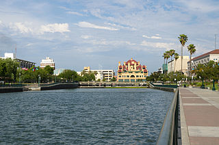
San Joaquin County, officially the County of San Joaquin, is a county located in the U.S. state of California. As of the 2020 census, the population was 779,233. The county seat is Stockton.

<span class="mw-page-title-main">Stanislaus County, California</span> County in California, United States

Stanislaus County is a county located in the San Joaquin Valley of the U.S. state of California. As of 2023, its estimated population is 564,404. The county seat is Modesto.

<span class="mw-page-title-main">Central Valley (California)</span> Flat valley that dominates central California

The Central Valley is a broad, elongated, flat valley that dominates the interior of California. It is 40–60 mi (60–100 km) wide and runs approximately 450 mi (720 km) from north-northwest to south-southeast, inland from and parallel to the Pacific coast of the state. It covers approximately 18,000 sq mi (47,000 km2), about 11% of California's land area. The valley is bounded by the Coast Ranges to the west and the Sierra Nevada to the east.

<span class="mw-page-title-main">Northern California</span> American geographic and cultural region

Northern California is a geographic and cultural region that generally comprises the northern portion of the U.S. state of California, spanning the northernmost 48 of the state's 58 counties. Its main population centers include the San Francisco Bay Area, the Greater Sacramento area, the Redding, California, area south of the Cascade Range, and the Metropolitan Fresno area. Northern California also contains redwood forests, along with most of the Sierra Nevada, including Yosemite Valley and part of Lake Tahoe, Mount Shasta, and most of the Central Valley, one of the world's most productive agricultural regions.

<span class="mw-page-title-main">Greater Richmond Region</span> Metropolitan statistical area in the United States

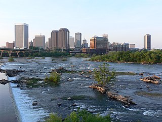
The Greater Richmond Region, the Richmond metropolitan area or Central Virginia, is a region and metropolitan area in the U.S. state of Virginia, centered on Richmond. The U.S. Office of Management and Budget (OMB) defines the area as the Richmond, VA Metropolitan Statistical Area, a Metropolitan Statistical Area (MSA) used by the U.S. Census Bureau and other entities. The OMB defines the area as comprising 17 county-level jurisdictions, including the independent cities of Richmond, Petersburg, Hopewell, and Colonial Heights. As of 2020, it had a population of 1,314,434, making it the 44th largest MSA in the country.

<span class="mw-page-title-main">Lynchburg metropolitan area</span> Metropolitan Statistical Area in Virginia, United States

The Lynchburg Metropolitan Statistical Area is a United States Metropolitan Statistical Area (MSA) in the state of Virginia, as defined by the Office of Management and Budget (OMB) as of June 2003. As of the 2000 census, the MSA had a population of 228,616. In 2009 this was estimated to have risen to 247,447; as of 2016, the Lynchburg MSA was estimated to have a population of 260,320, making it the fifth-largest metro area in the state.

California's major urban areas normally are thought of as two large megalopolises: one in Northern California and one in Southern California, separated from each other by approximately 382 miles or 615 km, with sparsely inhabited (relatively) Central Coast, Central Valley, and Transverse Ranges in between. Other ideas conceive of a single megalopolis encompassing both North and South, or a division of Coastal California vs. Inland California. These regional concepts are usually based on geographic, cultural, political, and environmental differences, rather than transportation and infrastructure connectivity and boundaries.

<span class="mw-page-title-main">Central California</span> Region of California in the United States

Central California is generally thought of as the middle third of the U.S. state of California, north of Southern California and south of Northern California. It includes the northern portion of the San Joaquin Valley, part of the Central Coast, the central hills of the California Coast Ranges and the foothills and mountain areas of the central Sierra Nevada.

<span class="mw-page-title-main">Transportation in the San Francisco Bay Area</span> Overview of transportation in the San Francisco Bay Area, California

People in the San Francisco Bay Area rely on a complex multimodal transportation infrastructure consisting of roads, bridges, highways, rail, tunnels, airports, seaports, and bike and pedestrian paths. The development, maintenance, and operation of these different modes of transportation are overseen by various agencies, including the California Department of Transportation (Caltrans), the Association of Bay Area Governments, San Francisco Municipal Transportation Agency, and the Metropolitan Transportation Commission. These and other organizations collectively manage several interstate highways and state routes, eight passenger rail networks, eight trans-bay bridges, transbay ferry service, local and transbay bus service, three international airports, and an extensive network of roads, tunnels, and bike paths.

<span class="mw-page-title-main">Transportation in California</span> Overview of the transport in the State of California

California's transportation system is complex and dynamic. Although known for its car culture and extensive network of freeways and roads, the state also has a vast array of rail, sea, and air transport. Several subway, light rail, and commuter rail networks are found in many of the state's largest population centers. In addition, with the state's location on the West Coast of the United States, several important ports in California handle freight shipments from the Pacific Rim and beyond. A number of airports are also spread out across the state, ranging from small general aviation airports to large international hubs like Los Angeles International Airport and San Francisco International Airport.

<span class="mw-page-title-main">Provo–Orem metropolitan area</span> Metropolitan region in Utah, United States

The Provo–Orem, UT Metropolitan Statistical Area, as defined by the United States Office of Management and Budget, is an area consisting of two counties in Utah, anchored by the cities of Provo and Orem. As of the 2020 census, the MSA had a population of 671,185.

<span class="mw-page-title-main">Salt Lake City metropolitan area</span> Metropolitan area in Salt Lake and Tooele counties in Utah, United States

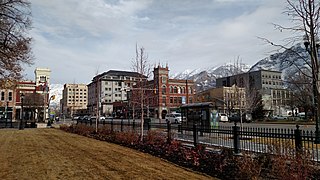
The Salt Lake City metropolitan area is the metropolitan area centered on the city of Salt Lake City, Utah. The Office of Management and Budget and the United States Census Bureau currently define the Salt Lake City, Utah Metropolitan Statistical Area as comprising two counties: Salt Lake and Tooele. As of the 2020 census, the MSA had a population of 1,257,936. The Salt Lake City Metropolitan Area and the Ogden-Clearfield Metropolitan Area were a single metropolitan area known as the Salt Lake City-Ogden Metropolitan Area until being separated in 2005.

<span class="mw-page-title-main">Ogden–Clearfield metropolitan area</span> Metropolitan area in Utah, United States of America

The Ogden-Clearfield, UT Metropolitan Statistical Area, as defined by the United States Office of Management and Budget, is an area consisting of four counties in north central Utah, anchored by the cities of Ogden and Clearfield. As of the 2010 census, the MSA had a population of 547,184. On February 28, 2013 the White House released a Bulletin Revising delineations of CSA's and MSA's, which led to the addition of Box Elder County to the Ogden-Clearfield Metropolitan Statistical Area, bringing the MSA population to 597,159. This county was removed in the latest definitions and added to the newly created Brigham City, micropolitan statistical area.

<span class="mw-page-title-main">Sacramento metropolitan area</span> Metropolitan area in California, United States

The Greater Sacramento area refers to a metropolitan region in Northern California comprising either the U.S. Census Bureau defined Sacramento–Roseville–Folsom metropolitan statistical area or the larger Sacramento–Roseville combined statistical area, the latter of which consists of seven counties, namely Sacramento, Yolo, Placer, Sutter, Yuba, counties.

<span class="mw-page-title-main">Metropolitan Fresno</span> Combined Statistical Area in California, United States

Metropolitan Fresno, officially Fresno–Hanford–Corcoran, CA CSA, is a metropolitan area in the San Joaquin Valley, in the United States, consisting of Fresno and Madera counties. It is the third-largest metropolitan region in Northern California, behind the San Francisco Bay Area and Greater Sacramento. It is also the 49th-largest CSA in the U.S. as of 2010 census.

<span class="mw-page-title-main">Heber, Utah micropolitan area</span> Micropolitan Statistical Area in the United States

The Heber Micropolitan Statistical Area, as defined by the United States Office of Management and Budget, is an area consisting of two counties in Utah. It is part of the Salt Lake City–Provo–Orem combined statistical area, along with the Salt Lake City metropolitan area, Ogden–Clearfield metropolitan area, and Provo–Orem metropolitan area.

References

  1. North Bay sometimes also includes Marin County, which is part of the San Francisco, CA MSA
  2. "New Report: As Northern California Megaregion Takes Shape, Megaproblems Intensify". Bay Area Council. 2016-06-30. Retrieved 2019-02-01.
  3. 1 2 "SPUR: The Northern California Megaregion" (PDF). SPUR.
  4. 1 2 3 4 "The Northern California Megaregion | Bay Area Council Economic Institute" . Retrieved 2019-02-01.
  5. "Where Exactly Is "the Bay Area"?". SPUR. 2018-06-18. Retrieved 2019-02-01.
  6. 1 2 3 4 Bureau, US Census. "Population and Housing Unit Estimates". www.census.gov. Retrieved 2019-02-01.
  7. "GDP by Metropolitan Area | U.S. Bureau of Economic Analysis (BEA)". www.bea.gov. Retrieved 2019-02-01.
  8. "Gross Domestic Product | U.S. Bureau of Economic Analysis (BEA)". www.bea.gov. Retrieved 2019-02-01.
  9. "Megaregion a vision for redistributing the California dream - SFChronicle.com". www.sfchronicle.com. 2018-07-27. Retrieved 2019-02-01.
  10. "Best Global Universities Rankings". US News.
  11. "Northern California - America 2050". www.america2050.org. Retrieved 2019-02-01.
  12. "The Northern California Megaregion – Definitions and Challenges - America 2050". www.america2050.org. Retrieved 2019-02-01.
  13. "CCJPA Vision Plan, What the Capitol Corridor Can Become". Capitol Corridor. Retrieved 2019-02-01.
  14. "Northern California Mega-Region Goods Movement Study | Plans + Projects | Our Work | Metropolitan Transportation Commission". mtc.ca.gov. Retrieved 2019-02-01.
  15. "High-Speed Rail: Northern California at a Glance" (PDF).
  16. "Total Gross Domestic Product for San Francisco-Oakland-Hayward, CA (MSA)", fred.stlouisfed.org
  17. "Total Gross Domestic Product for San Jose-Sunnyvale-Santa Clara, CA (MSA)", fred.stlouisfed.org
  18. "Total Gross Domestic Product for Sacramento--Roseville--Arden-Arcade, CA (MSA)", fred.stlouisfed.org
  19. "Total Gross Domestic Product for Stockton-Lodi, CA (MSA)", fred.stlouisfed.org
  20. "Total Gross Domestic Product for Santa Rosa, CA (MSA)", fred.stlouisfed.org
  21. "Gross Domestic Product: All Industries in Solano County, CA", fred.stlouisfed.org
  22. "Total Gross Domestic Product for Salinas, CA (MSA)", fred.stlouisfed.org
  23. "Gross Domestic Product: All Industries in Stanislaus County, CA", fred.stlouisfed.org
  24. "Total Gross Domestic Product for Santa Cruz-Watsonville, CA (MSA)", fred.stlouisfed.org
  25. "Gross Domestic Product: All Industries in Napa County, CA", fred.stlouisfed.org
  26. "Gross Domestic Product: All Industries in Merced County, CA", fred.stlouisfed.org
  27. "Total Gross Domestic Product for Yuba City, CA (MSA)", fred.stlouisfed.org
  28. "California Metropolitan Planning Organizations (MPOs) and Regional Transportation Planning Agencies (RTPAs)" (PDF).
  29. "GDP by County | U.S. Bureau of Economic Analysis (BEA)". www.bea.gov. Retrieved 2019-02-01.
  30. U.S. Bureau of Labor Statistics (1984-01-01). "Consumer Price Index for All Urban Consumers: All items less food and energy". FRED, Federal Reserve Bank of St. Louis. Retrieved 2019-02-01.
  31. "Demographic Projections". www.dof.ca.gov. Retrieved 2019-02-01.