
The Dumbarton Bridge is the southernmost of the highway bridges across San Francisco Bay in California. Carrying over 70,000 vehicles and about 118 pedestrian and bicycle crossings daily, it is the shortest bridge across San Francisco Bay at 1.63 miles. Its eastern end is in Fremont, near Newark in the San Francisco Bay National Wildlife Refuge, and its western end is in Menlo Park. Bridging State Route 84 across the bay, it has three lanes each way and a separated bike/pedestrian lane along its south side. Like the San Mateo Bridge to the north, power lines parallel the bridge.

The San Francisco–Oakland Bay Bridge, known locally as the Bay Bridge, is a complex of bridges spanning San Francisco Bay in California. As part of Interstate 80 and the direct road between San Francisco and Oakland, it carries about 260,000 vehicles a day on its two decks. It has one of the longest spans in the United States.
The Association of Bay Area Governments (ABAG) is a regional planning agency incorporating various local governments in the San Francisco Bay Area in California. It encompasses nine counties surrounding the San Francisco Bay. Those counties are Alameda, Contra Costa, Marin, Napa, San Francisco, San Mateo, Santa Clara, Solano, and Sonoma. It has the ability to establish housing and transportation goals for cities to minimize urban sprawl by requiring that housing be zoned for near new workplace construction. It deals with land use, housing, environmental quality, and economic development. Non-profit organizations as well as governmental organizations can be members. All nine counties and 101 cities within the Bay Area are voluntary members of ABAG.

The Carquinez Bridge is a pair of parallel bridges spanning the Carquinez Strait at the northeastern end of San Francisco Bay. They form the part of Interstate 80 between Crockett and Vallejo, California.

The Benicia–Martinez Bridge refers to three parallel bridges which cross the Carquinez Strait just west of Suisun Bay in California; the spans link Benicia on the north side with Martinez on the south.

The Antioch Bridge is an automobile, bicycle, and pedestrian bridge in the western United States. Located in northern California, it crosses the San Joaquin River-Stockton Deepwater Shipping Channel, linking Antioch in Contra Costa County with Sherman Island in southern Sacramento County, near Rio Vista.

A metropolitan planning organization (MPO) is a federally mandated and federally funded transportation policy-making organization in the United States that is made up of representatives from local government and governmental transportation authorities. They were created to ensure regional cooperation in transportation planning. MPOs were introduced by the Federal-Aid Highway Act of 1962, which required the formation of an MPO for any urbanized area (UZA) with a population greater than 50,000. Federal funding for transportation projects and programs are channeled through this planning process. Congress created MPOs in order to ensure that existing and future expenditures of governmental funds for transportation projects and programs are based on a continuing, cooperative, and comprehensive ("3-C") planning process. Statewide and metropolitan transportation planning processes are governed by federal law. Transparency through public access to participation in the planning process and electronic publication of plans now is required by federal law. As of 2015, there are 408 MPOs in the United States.

The Clipper card is a reloadable contactless smart card used for automated fare collection in the San Francisco Bay Area. First introduced as TransLink in 2002 by the Metropolitan Transportation Commission (MTC) as a pilot program, it was rebranded in its current form on June 16, 2010. Like other transit smart cards such as the Oyster card, the Clipper card is a credit card-sized stored-value card capable of holding both cash value and transit passes for the participating transit agencies. In addition to the traditional plastic card, Clipper is available as a virtual card in Google Wallet and Apple Wallet. Clipper is accepted by nearly all public transit services in the Bay Area, including but not limited to Muni, BART, Caltrain, AC Transit, SamTrans, Golden Gate Transit, Golden Gate Ferry, San Francisco Bay Ferry, and VTA.
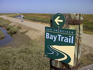
The San Francisco Bay Trail is a bicycle and pedestrian trail that when finished will allow continuous travel around the shoreline of San Francisco Bay. As of 2020, 356 miles (573 km) of the trail have been completed. When finished, the trail will be over 500 miles (800 km) of paved and gravel paths, bike lanes, and sidewalks, linking 47 cities across nine counties and crossing seven toll bridges. It is a project of the Association of Bay Area Governments (ABAG) and the Metropolitan Transportation Commission (MTC), in collaboration with other agencies, private companies, non-profit organizations, and advocacy groups.

The Golden Gate Bridge, Highway and Transportation District is a special-purpose district that owns and operates three regional transportation assets in the San Francisco Bay Area: the iconic Golden Gate Bridge, the Golden Gate Ferry system and the Golden Gate Transit system. All three assets connect Marin County with San Francisco.
The Massachusetts Department of Transportation (MassDOT) oversees roads, public transit, aeronautics, and transportation licensing and registration in the US state of Massachusetts. It was created on November 1, 2009, by the 186th Session of the Massachusetts General Court upon enactment of the 2009 Transportation Reform Act.
The Bay Area Toll Authority (BATA) is a state agency created by the California State Legislature in 1997 to administer the auto tolls on the San Francisco Bay Area's seven state-owned toll bridges. On January 1, 1998, the Metropolitan Transportation Commission (MTC) — the transportation planning, financing and coordinating agency for the nine-county region — began operations as BATA. In August 2005, the California Legislature expanded BATA's responsibilities to include administration of all toll revenue and joint oversight of the toll bridge construction program with Caltrans and the California Transportation Commission.

The Tampa Bay Area Regional Transit Authority, or TBARTA, is a regional transportation agency of the U.S. state of Florida which was created on July 1, 2007. The purpose of the agency is "to plan, develop, finance, construct, own, purchase, operate, maintain, relocate, equip, repair, and manage multimodal systems in Hernando, Hillsborough, Manatee, Pasco, and Pinellas Counties." The agency coordinates its efforts with the Florida Department of Transportation to improve transportation in the Tampa Bay Area.

Steve Heminger served as the former executive director of the San Francisco Bay Area's Metropolitan Transportation Commission (MTC) from 2001 until his retirement in 2019. Since then, he has been serving as a director for the San Francisco Municipal Transportation Agency (SFMTA).
Bike East Bay, formerly known as East Bay Bicycle Coalition, is a Californian non-profit organization that worked since 1972 toward "promoting bicycling as an everyday means of transportation and recreation" in Alameda and Contra Costa counties of the California's East Bay. As a tax-exempt 501(c)3 grassroots bicycle advocacy organization, Bike East Bay endeavors to broaden awareness of bicycling with local, regional, and state government agencies and their staff, as well as elected officials, and the general public they represent.

The San Mateo–Hayward Bridge is a bridge crossing the American state of California's San Francisco Bay, linking the San Francisco Peninsula with the East Bay. The bridge's western end is in Foster City, a suburb on the eastern edge of San Mateo. The eastern end of the bridge is in Hayward. It is the longest fixed-link bridge in California and the 25th longest in the world by length. The bridge is owned by the state of California, and is maintained by California Department of Transportation (Caltrans), the state highway agency. Further oversight is provided by the Bay Area Toll Authority (BATA).
The San Francisco Estuary Partnership (Partnership) is one of the 28 National Estuary Programs created in the 1987 Amendments to the Clean Water Act. The Partnership is a non-regulatory federal-state-local collaboration working to restore water quality and manage the natural resources of the San Francisco Bay-Sacramento–San Joaquin River Delta estuary. The Partnership works with over 100 municipalities, non-profits, governmental agencies, and businesses and helps develop, find funding for, and implement over 40 projects and programs aimed at improving the health of the estuary. The partnership either directly implements these projects, or administers and manages grants, holds educational workshops and highlights project results. The Partnership is also the official representative for the San Francisco Bay region to the Most Beautiful Bays in the World.
Plan Bay Area is the long-range Regional Transportation Plan and Sustainable Communities Strategy for the nine-county San Francisco Bay Area. It is the Bay Area's implementation of the Sustainable Communities and Climate Protection Act of 2008, or SB 375, a California law that aims to integrate sustainable strategies to reduce transportation-related pollution and external greenhouse gas emissions. The plan addresses the plan identifies goals and develops strategies for transportation, land-use, and housing to accommodate the region's expected growth and needs over a long-term planning horizon. It is jointly prepared by the Metropolitan Transportation Commission (MTC) and the Association of Bay Area Governments (ABAG). The current plan, which includes projections and strategies through the year 2040, is called Play Bay Area 2040. Plan Bay Area 2050 is currently under development.
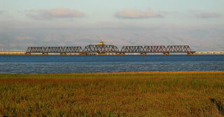
The Dumbarton Rail Corridor is a proposed transbay passenger rail line which would reuse the right-of-way that was initially constructed from 1907–1910 as the Dumbarton Cut-off. The Dumbarton Cut-off includes the first structure to span San Francisco Bay, the 1910 Dumbarton Rail Bridge, although the vintage Cut-off bridges would likely be replaced prior to activating new passenger service. Dumbarton Rail Corridor would provide service between Union City in the East Bay and Menlo Park on the Peninsula, with train service continuing to both San Francisco and San José along the existing Caltrain tracks. It has been in the planning stages since 1988, and would be the first above-ground transbay rail line since Key System electric trains stopped running on the lower deck of the Bay Bridge in 1958, and the first new transbay crossing of any kind since the completion of the Transbay Tube in 1974.

The Northern California megaregion, distinct from Northern California, is an urbanized region of California consisting of many large cities including San Jose, San Francisco, Sacramento, and Oakland. There are varying definitions of the megaregion, but it is generally seen as encompassing the San Francisco Bay Area, the Sacramento area, northern San Joaquin Valley, and the Monterey Bay Area.