Like other ETC systems, FasTrak is designed to eliminate the need for vehicles to stop at toll booths, thereby reducing traffic congestion commonly associated with toll collection. Its implementation aligns with the U.S. Department of Transportation's Intelligent Transportation Systems initiative.
California's toll facilities are decentralized and managed by various local public agencies and special-purpose districts, rather than being operated directly by the California Department of Transportation (Caltrans) or another centralized state agency. Concerned about the potential development of incompatible ETC systems, the California State Legislature passed Senate Bill 1523 in 1990. This legislation required Caltrans to develop a statewide ETC specification that all toll agencies were mandated to follow.[1][2]
In 1993, the Transportation Corridor Agencies opened the Foothill Toll Road in Orange County, marking the first implementation of the standardized ETC system, which it branded as FasTrak. The state continues to delegate the responsibility for issuing and managing FasTrak accounts to individual toll agencies.
Operations and functionality
Technology
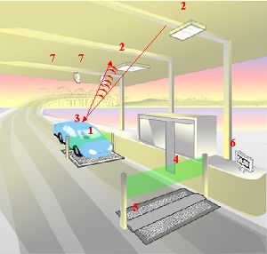
Diagram of the FasTrak toll collection system: As a vehicle enters the toll point, sensors (1) detect it and antennas (2) read the FasTrak transponder (3) on the vehicle. As the vehicle passes through the exit light curtain (4), a treadle (5) determines its axle count to calculate the correct toll, and the account is charged. A display (6) gives feedback to the driver. If no transponder is detected, cameras (7) photograph the license plate.
FasTrak uses radio-frequency identification (RFID) technology operating at 915MHz to identify vehicles via a transponder mounted on the vehicle (typically to the windshield). As a vehicle passes through a toll point, antennas detect and read the transponder, and the system automatically deducts the toll from a prepaid account.
Caltrans was given the mandate to develop and maintain an open, statewide ETC specification known as "Title 21" after it was added to Title 21 of the California Code of Regulations.[2][3] FasTrak transponders are compatible across California toll roads but not with out-of-state systems like E-ZPass. In 2018, the state began a transition to the national ISO/IEC 18000-63 (6C) standard to support future nationwide interoperability.[4]
If a transponder is not detected, cameras photograph the vehicle’s license plate and attempt to match it to a FasTrak account. If no account is found, either an invoice with no penalty (in locations supporting "pay by plate") or a violation notice is issued and mailed to the registered owner of the vehicle.[5]
Tag types
A switchable FasTrak device used by the Metro ExpressLanes in Los Angeles CountyPicture of OCTA Fastrak Flex transponder compliant with 6C standard.
FasTrak supports multiple transponder types:
Standard tag – A hard-case transponder used on all FasTrak toll roads.
Sticker tag – A low-cost adhesive tag issued by some agencies.[6]
FasTrak Flex – A switchable tag (settings for 1, 2, or 3+ occupants) required for HOV toll discounts.[7][8][9][10][11]
A FasTrak CAV tag was also made available to those with a Clean Air Vehicle (CAV) decal for applicable toll discounts. When the federal law authorizing the decal program expired on September 30, 2025, existing CAV tags automatically converted to function like Flex tags.[12][13]
Some toll roads allow carpoolers to avoid tolls by placing their standard tag in a mylar bag to block the radio signals, others require a FasTrak Flex transponder.[14][15][16]
Service center operations
All Bay Area toll facilities use a centralized billing and customer service system operated by the Bay Area Toll Authority (BATA).[17]
Transportation Corridor Agencies, operator of the Orange County toll roads, also operates the billing and customer service system for the San Bernardino County high-occupancy toll lanes.[18]
All other Southern California agencies maintain separate billing and customer service systems.[20]
Some agencies "sell" (charge the initial prepaid toll deposit) transponders in a retail setting, such as Costco stores. Customers must still register their transponders with the issuing agency.[8][21][22]
Fees
FasTrak account fees and requirements vary by issuing agency:[9]
FasTrak antennae that pull data used to generate 5-1-1 traffic information
In 2008, researchers found that FasTrak transponders lacked encryption and could be queried or updated remotely.[29][30][31] As the Title 21 specification is publicly available, this raised concerns about potential misuse.[32] Transponders are also used to generate 5-1-1 traffic data, using sensors and antennae placed across various freeways.[30] The Metropolitan Transportation Commission responded by reviewing the system’s security and exploring possible improvements with vendors.[31]
History
After the first electronic toll collection (ETC) system in North America was implemented on the Dallas North Tollway in 1989, various toll agencies in California began expressing interest in similar systems. Given that toll roads and bridges in the state are managed by different government entities, there was concern about the potential emergence of multiple, incompatible ETC systems. To address this, the California State Legislature passed Senate Bill 1523 in 1990, directing the California Department of Transportation (Caltrans) to create a standardized statewide technical specification for ETC systems.[2] California subsequently became the first U.S. state to require all toll facilities to use a uniform ETC system.[33] This specification was later codified in Title 21, Division 2, Chapter 16 of the California Code of Regulations.[32]
The original FasTrak transponder was a device about the size of a Walkman, into which a smart card was inserted.[36] However, the device was costly to produce and the smart card offered little advantage to customers.[37] By 1995, when the 91 Express Lanes opened, the transponders had been redesigned to be coaster-sized.[38]
San Francisco–Oakland Bay Bridge toll plaza in 2008. Booths now display "FasTrak or Invoice" following the phaseout of cash payments.
Adapting FasTrak for California’s toll bridges required additional modifications, especially to handle 18 different toll classifications for trucks. After a trial at the Carquinez Bridge in 1996 revealed accuracy issues,[39] improvements were made, before the bridge adopted FasTrak in 1997. Despite these developments, other state-run Bay Area toll bridges did not adopt the system until October 2000, due to bureaucratic and technical delays.[40] The independently managed Golden Gate Bridge introduced FasTrak a few months earlier in July 2000.
The San Diego-Coronado Bridge briefly used FasTrak before tolls were eliminated in 2002. In 2005, the Bay Area FasTrak Customer Center opened, consolidating services for regional bridges and the Golden Gate Bridge.[41]
FasTrak has since expanded to cover all new toll facilities in California, which are required by law to adopt the system. In 2009, San Francisco International Airport began accepting FasTrak in its parking garages.[42]
The introduction of the Metro ExpressLanes in Los Angeles in 2012 led to the introduction of FasTrak Flex transponders with occupancy switches (1, 2, or 3+ riders), allowing automated toll calculations for carpools and solo drivers.[43] TCA began issuing switchable transponders in 2013,[44] followed by the 91 Express Lanes and the Bay Area in 2015.[14][45]
The TCA introduced a sticker transponder in 2019 to replace the earlier plastic model. The new sticker transponders cost the agency less than $1 each, compared to approximately $20 for the plastic version. The lower cost enabled TCA to eliminate monthly account maintenance fees and the requirement for a prepaid deposit.[46][47][48]
California continues moving toward open road tolling, eliminating cash transactions in favor of transponders, license plate tolling, and online or phone payments. The Golden Gate Bridge became fully cashless in March 2013,[49] followed by TCA-operated toll roads in May 2014.[50] In 2019, California approved the phaseout of toll takers on all state-owned bridges.[51] Due to the COVID-19 pandemic, electronic-only tolling was implemented in March 2020 and became permanent by 2021.[52] The only remaining cash-accepting toll road is the South Bay Expressway, which has unstaffed cash machines.[53]
In line with MAP-21 all ETC systems nationwide were required to achieve interoperability by October 1, 2016. In response, California passed Assembly Bill 493 in 2013, enabling collaboration between Caltrans and toll agencies to comply with the mandate.[54] California regulators later approved a phase-in of transponder technology using the ISO/IEC 18000-63 (6C) standard. Rollout began in 2018 and was expected to be complete by 2024.[4]
California state law prohibits tolling agencies from sharing information regarding tolls collected to other states.[55] However in the interim, FasTrak member agencies may pursue one-way interoperability with their account holders. In June 2025, FasTrak users under the TCA system were permitted to use their FasTrak toll tags on toll roads and managed lanes operated by the North Texas Tollway Authority (NTTA) and North East Texas Regional Mobility Authority (NETRMA).[56] TCA will later permit their users to use FasTrak on toll roads operated by Texas Department of Transportation (TxDOT) and the Harris County Toll Road Authority (HCTRA).[57]
Toll facilities using FasTrak
Current
All eight toll bridges only collect tolls in one direction. All other toll facilities collect tolls in either direction, though some high-occupancy toll lane toll lanes exist in only one direction of their freeway in parts or the whole of their length.
^ indicates that carpools require the switchable "FasTrak Flex" transponder. HOV2+ indicates that carpools require two or more persons. HOV3+ indicates that carpools require three or more persons. † indicates that two-person carpools are tolled differently than solo drivers or carpools with three or more, typically at a rate intermediate between the solo and 3+ rates
While the California state highway system officially treats the following routes as discontinuous through the following national parks, respectively, signs within these parks and some commercially produced maps may show these highways as continuous. The park entrance fees are handled by the National Park Service, not FasTrak or Caltrans.
The 17-Mile Drive, a scenic toll road in Pebble Beach is owned and operated by the Pebble Beach Company and does not utilize FasTrak for toll collection.[103]
Notes
↑The westbound I-580 Express Lanes extend further west to San Ramon Road/Foothill Road in Dublin/Pleasanton
↑The southbound I-680 Sunol Express Lanes extend further south to SR237 in Milpitas
↑The southbound I-680 Contra Costa County Express Lanes extend further north to Marina Vista Avenue in Martinez
12The southbound I-880 Express Lanes extend further north to Hegenberger Road in Oakland and further south to SR237 in Milpitas
↑Not including the already completed portion of the Express Lanes from the Central Expressway to US 101 north
References
↑"Senate Bill 1523". California Legislative Information. Retrieved April 12, 2025.
12California Department of Transportation Division of Traffic Operations (2013). "Title 21 Support". California Department of Transportation. Archived from the original on December 30, 2013. Retrieved December 29, 2013.
↑Downey, Cheryl (August 13, 1993). "Toll Tech: 4 Ways to Pay: Transportation: Video Enforcement Will Capture License Plates When Drivers Don't Pay on Foothill Toll Road". Orange County Register. p.B4.
↑Downey, Cheryl (July 29, 1994). "County Tollway Officials Are Having Second Thoughts About Expensive Toll-Paying 'Smart Cards'". Orange County Register. p.C4.
↑Pund, Ernest E. (December 24, 1995). "Highway 91 About to Take Its First Toll". The Press-Enterprise. Riverside, CA. p.A1.
↑Los Angeles County Metropolitan Transportation Authority. "Metro ExpressLanes FAQ". Archived from the original on June 9, 2012. Retrieved July 6, 2012.
↑"Cash or Credit Payment". South Bay Expressway. San Diego Association of Governments. Archived from the original on March 19, 2022. Retrieved September 18, 2021.
↑"I-5 Express Lanes Project". TransNet (San Diego Association of Governments). Retrieved March 1, 2023. Later phases (2020-2035) will upgrade the carpool lanes to Express Lanes
This page is based on this Wikipedia article Text is available under the CC BY-SA 4.0 license; additional terms may apply. Images, videos and audio are available under their respective licenses.