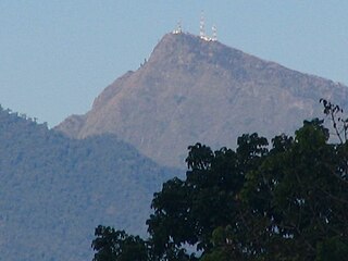
Mount Apo, also known locally as Apo Sandawa, is a large solfataric, dormant stratovolcano on the island of Mindanao, Philippines. With an elevation of 2,954 meters (9,692 ft) above sea level, it is the highest-mountain in the Philippine Archipelago, Mindanao and 24th-highest peak of an island on Earth. Located between Davao City and Davao del Sur in the Davao Region, and Cotabato in Soccsksargen, Mount Apo is the most-prominent mountain in the Philippines. The peak overlooks from Davao City 45 kilometers (28 mi) to the northeast, Digos 25 kilometers (16 mi) to the southeast, and Kidapawan 20 kilometers (12 mi) to the west. It is a protected area and a Natural Park of the Philippines.

Walden's hornbill locally called dulungan, also known as the Visayan wrinkled hornbill, rufous-headed hornbill or writhed-billed hornbill, is a critically endangered species of hornbill living in the rainforests on the islands of Negros and Panay in the Philippines. It is closely related to the writhed hornbill, but can be recognized by the yellow throat and ocular skin in the male, and the blue throat and ocular skin in the female. Its binomial name commemorates the Scottish ornithologist Viscount Walden.

Mount Isarog is an active stratovolcano located in the province of Camarines Sur, Philippines, on the island of Luzon. The mountain has active fumaroles and hot springs. It has an elevation of 2,011 m (6,598 ft) above mean sea level.

The white-winged cuckooshrike, also known as white-winged cicadabird or white-winged graybird, is a species of bird in the family Campephagidae. It is endemic to the Philippines found on the islands of Negros, Panay and formerly on Guimaras. Some taxonomists place this species in the genus Analisoma.
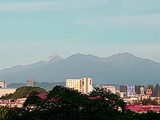
Mount Kitanglad is an inactive volcano located in the Kitanglad Mountain Range in Bukidnon province on Mindanao island. It is the fourth highest mountain in the Philippines and has an approximate height of 2,899 metres (9,511 ft). It is located between Malaybalay City and the municipalities of Lantapan, Impasugong, Sumilao, and Libona. It is home to one of the Philippines' few remaining rainforests.
Kalatungan Mountain Range is a mountain range in the central portion of the province of Bukidnon, the Philippines. It is one of the few areas in the province covered with old growth or mossy forests. It covers an area of approximately 213.0134 km2 (82.24493 mi2), with about 113.7175 km2 (43.90657 mi2) identified as part of the critical watershed area declared under Presidential Decree 127, issued on June 29, 1987. The water from two rivers, the Muleta and Manupali Rivers, flood the multimillion dam project of the Philippine National Irrigation Administration (NIA). The rivers drain into the Pulangi River, the site of a National Power Corporation hydroelectric dam.

The Northern Negros Natural Park is a protected area of the Philippines located in the northern mountainous forest region of the island of Negros in the Visayas. It is spread over five municipalities and six cities in the province of Negros Occidental and is the province's largest watershed and water source for seventeen municipalities and cities including the Bacolod metropolitan area. The park was established first as a forest reserve spanning 107,727 hectares on 28 April 1935 through Administrative Act No. 789 signed by Governor-General Frank Murphy. On 7 August 1946, the Northern Negros Forest Reserve was reduced to its present area of 80,454.5 hectares with the signing of Proclamation No. 798 by President Manuel Roxas. In 2005, the protected area was converted into a natural park under the National Integrated Protected Areas System (NIPAS) Act by virtue of Proclamation No. 895 signed by President Gloria Arroyo.
Sibalom Natural Park is a 5,511.47-hectare (13,619.1-acre) protected area in the Philippines on the island of Panay in the municipality of Sibalom, Antique. It was proclaimed a natural park on 23 April 2000. It is considered one of the last remaining lowland rainforests on Panay.
The Mount Inayawan Range Natural Park is a protected area of forested mountains in the Northern Mindanao region of the Philippines. The park encompasses the mountain range also known as Mount Iniaoan located in the landlocked municipality of Nunungan in Lanao del Norte and covers a total area of 3,632.74 hectares with a buffer zone of 889.04 hectares. The area was officially designated as a natural park on 30 July 2007 through Proclamation No. 1344 signed by President Gloria Arroyo. It is a critical watershed area and the largest remaining rainforest in Lanao del Norte.
The Mount Timolan Protected Landscape is a protected area covering Mount Timolan and its surrounding forested landscape in the region of Zamboanga Peninsula on Mindanao in the Philippines. The park encompasses an area of 1,994.79 hectares and a buffer zone of 695.39 hectares in the municipalities of San Miguel, Guipos and Tigbao in the province of Zamboanga del Sur. It was established on 14 August 2000 through Proclamation Order No. 354 issued by President Joseph Estrada. The park was also earlier established by the provincial government of Zamboanga del Sur as a provincial park and wildlife sanctuary known as the Zamboanga del Sur Provincial Park through Provincial Ordinance No. 3 in 1992.

The Pasonanca Natural Park is a protected area that preserves a major watershed in the southern Philippine island of Mindanao in the Zamboanga Peninsula. It contains the headwaters of the Tumaga River in the southern Zamboanga Cordillera mountain range that serves the water requirements of some 800,000 residents in Zamboanga City. It was named after the village of Pasonanca located in the city's northern fringes where the Pasonanca Park, a public eco-park, and the Abong-Abong Park, a pilgrimage site, can also be found.
The Mimbilisan Protected Landscape is a protected landscape area located in the province of Misamis Oriental in Northern Mindanao in the Philippines. It was established in 1936 to protect the watershed forest surrounding the Mimbilisan Falls in the municipality of Talisayan declared through Proclamation No. 51 by President Manuel Luis Quezon. It had an initial area of 72 hectares and is an important source for Mimbilisan Water System that supplies water to the surrounding communities in eastern Misamis Oriental. In 1999 and again, in 2007, the forest reserve was reestablished as a protected landscape under the National Integrated Protected Areas System with the enactment of Proclamation No. 134 and Republic Act No. 9494. It is one of five declared protected areas of the Philippines in Misamis Oriental.
The Buenavista Protected Landscape is a conservation area and an archaeological site located on Bondoc Peninsula in the southern Luzon province of Quezon in the Philippines. It conserves an important watershed area composed of secondary-growth forest, grassland and coconut land in the rural village of Buenavista within the coastal municipality of Mulanay. The area was primarily set aside for watershed protection and timber production in 1937 covering approximately 356 hectares. In 2000, it was reestablished as a protected landscape area under the National Integrated Protected Areas System. The area is known as the site of an ancient village containing unique limestone graves discovered in 2011. The protected area, including the limestone tombs of Kamhantik were recommended by various scholars to be included in the tentative list of UNESCO World Heritage Sites, yet no government or private entities have yet to file a tentative nomination to the UNESCO Secretariat.

The Sierra Madre is the longest mountain range in the Philippines. Spanning over 540 kilometers (340 mi), it runs from the province of Cagayan down to the province of Quezon, forming a north–south direction on the eastern portion of Luzon, the largest island of the archipelago. It is bordered by the Pacific Ocean to the east, Cagayan Valley to the northwest, Central Luzon to the midwest, and Calabarzon to the southwest. Some communities east of the mountain range, along the coast, are less developed and so remote that they could only be accessed by taking a plane or a boat.
The Calbayog Pan-as–Hayiban Protected Landscape, also known as the Calbayog Watershed, is a watershed and protected area located northwest of the city of Calbayog, Province of Samar in Oquendo District between Tinambacan District and San Isidro, Northern Samar in the Philippines. It is a mountainous region in the Tanaoan Ridge within the Mount Zamal Range that divides the three provinces of Samar. The protected area extends along the valley of the Hayiban River, the primary source of water for the Calbayog Water District. It consists of old growth trees and a system of rivers, waterfalls and streams capable of generating 2,279 liters per day. It also contains the Pan-as Falls and surrounding landscape which also supplies hydroelectric power to the city. The area was declared a forest reserve in 1967 known as the Pan-as Falls–Hayiban Watershed Forest Reserve with a total area of 7,832 hectares. In 1998, through Proclamation No. 1158 issued by President Fidel Ramos, the watershed was reclassified as a protected landscape. It is one of four protected areas in the island of Samar.

Mounts Banahaw–San Cristobal Protected Landscape is a protected landscape park in the Calabarzon region of the Philippines, 120 kilometres (75 mi) south of Manila. It is the second largest protected area in Calabarzon, after the Upper Marikina River Basin Protected Landscape, with an area of 10,900.59 hectares. The park is located at the border of Laguna and Quezon provinces and includes the features it is named after: Mount Banahaw and, 7 kilometres (4.3 mi) to its west, Mount San Cristobal.

The Angat Watershed Forest Reserve is a conservation area that protects the drainage basin in the southern Sierra Madre range north of Metro Manila in the Philippines where surface water empties into the Angat River and its distributaries. It is spread over an area of 62,309 hectares in the eastern portion of Bulacan and northern Rizal province at an altitude of between 490 and 1,206 metres. The conservation area also extends to the provinces of Nueva Ecija and Quezon and is centered on an artificial lake created by the Angat Dam which, together with the Ipo Dam located 7.5 kilometres (4.7 mi) downstream, supply 97% of the water requirement of Metro Manila via an aqueduct system to the La Mesa Dam and Reservoir and the Balara Filtration Plant in Quezon City. The Angat Dam and Reservoir is also a major source of hydroelectricity for Metro Manila and surrounding provinces, contributing some 200 megawatts to the Luzon grid. The watershed is a popular birdwatching site and is a biodiversity hotspot containing most of the remaining closed-canopy forests in Central Luzon.

The Pantabangan–Carranglan Watershed Forest Reserve is a conservation area located in the upper reaches of the Pampanga River in Nueva Ecija, Philippines, and borders the Sierra Madre and Caraballo Mountains in Aurora and Nueva Vizcaya. It encompasses 84,500 hectares of the drainage basin surrounding the Pantabangan Lake, an impoundment of the Pampanga River by the Pantabangan Dam. The multi-purpose dam is situated at the confluence of Pampanga River's two headwaters, namely the Pantabangan and Carranglan Rivers in the municipality of Pantabangan. It stretches above the dam site for 21 kilometres (13 mi) to where Carranglan River originates in the Caraballo on the north, and for 18 kilometres (11 mi) to where Pantabangan River originates in the Sierra Madre on the east. It is considered a critical watershed for the agricultural economy and hydroelectric power generation in the region of Central Luzon.

The Samar Island Natural Park, in Samar, is the largest contiguous tract of old-growth forest in the Philippines. It is the country's largest terrestrial protected area, with an area of 333,300 hectares. The buffer is spread north to south over the island's three provinces and totals 458,700 hectares, about a third of the entire island of Samar.

The Pamitinan Protected Landscape is a Philippine protected area of approximately 608 hectares in the Sierra Madre mountain range, just 34 kilometres (21 mi) northeast of Manila. It contains and protects the Montalban Gorge formed by the Marikina River that separates Mount Pamitinan and Mount Binacayan in the municipality of Rodriguez in Rizal. Established in 1996 through Proclamation No. 901 issued by President Fidel Ramos, the park is originally a component of the Mariquina Reserve founded in 1904 to protect the watershed of the Marikina River that supplied water to the city of Manila from the Wawa Dam located just above the Montalban Gorge in the early 1900s.

