
Panay is the sixth-largest and fourth-most populous island in the Philippines, with a total land area of 12,011 km2 (4,637 sq mi) and a total population of 4,542,926, as of 2020 census. Panay comprises 4.4 percent of the entire population of the country. The City of Iloilo is its largest settlement with a total population of 457,626 inhabitants, as of 2020 census.
Aklan, officially the Province of Aklan, is a province in the Western Visayas region of the Philippines. Its capital and largest town is Kalibo. The province is situated in the northwest portion of Panay Island, bordering Antique to the southwest, and Capiz to the southeast. Aklan faces the Sibuyan Sea and Romblon province to the north.
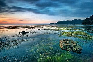
Buruanga, officially the Municipality of Buruanga, is a municipality in the province of Aklan, Philippines. It is the farthest town of Aklan from its provincial capital. According to the 2020 census, it has a population of 19,357 people.

Sibalom, officially the Municipality of Sibalom,, is a municipality in the province of Antique, Philippines. According to the 2020 census, it has a population of 63,833 people. Thus, making it a suburb of San Jose, the second most populous municipality in the province of Antique and fifth largest municipality in terms of land area, with a total area of 201.30 square kilometers.

Rafflesia speciosa is a parasitic plant species of the genus Rafflesia. It is endemic to the Philippine island of Panay. R. speciosa is the third Rafflesia species documented to exist in the Philippines, after R. manillana and R. schadenbergiana. It belongs to the medium-sized Rafflesia. The species was named by Julie Barcelona and Edwino Fernando.

The Bulabog Putian National Park is a protected wildlife and natural park located in the towns of Dingle and San Enrique in the province of Iloilo on the island of Panay in the Western Visayas region. The park covers an area of 854.33 hectares along a 40 kilometers (25 mi) trail in this rainforest. It was established in 1961 through Proclamation No. 760 signed by President Carlos P. Garcia. The park is known for its unique geological formation and is the only limestone mountain formation in Iloilo. It is also known as the location of the Cry of Lincud that started the Philippine Revolution in Iloilo in 1898.
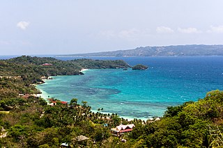
The Northwest Panay Peninsula Natural Park is located on the island of Panay, in the provinces of Aklan and Antique of the Philippines which was proclaimed a natural park by President Gloria Macapagal Arroyo on 18 April 2002. The Northwest Panay Peninsula Natural Park has an area of 120.09 km2, found within the municipalities of Nabas, Malay, Buruanga, Libertad and Pandan.

The Northern Negros Natural Park is a protected area of the Philippines located in the northern mountainous forest region of the island of Negros in the Visayas. It is spread over five municipalities and six cities in the province of Negros Occidental and is the province's largest watershed and water source for seventeen municipalities and cities including the Bacolod metropolitan area. The park was established first as a forest reserve spanning 107,727 hectares on 28 April 1935 through Administrative Act No. 789 signed by Governor-General Frank Murphy. On 7 August 1946, the Northern Negros Forest Reserve was reduced to its present area of 80,454.5 hectares with the signing of Proclamation No. 798 by President Manuel Roxas. In 2005, the protected area was converted into a natural park under the National Integrated Protected Areas System (NIPAS) Act by virtue of Proclamation No. 895 signed by President Gloria Arroyo.
The Mount Inayawan Range Natural Park is a protected area of forested mountains in the Northern Mindanao region of the Philippines. The park encompasses the mountain range also known as Mount Iniaoan located in the landlocked municipality of Nunungan in Lanao del Norte and covers a total area of 3,632.74 hectares with a buffer zone of 889.04 hectares. The area was officially designated as a natural park on 30 July 2007 through Proclamation No. 1344. It is a critical watershed area and the largest remaining rainforest in Lanao del Norte.
The Manleluag Spring Protected Landscape is a protected area containing natural hot springs in the Ilocos Region of the Philippines. It is one of 34 protected landscapes in the Philippines located in the municipality of Mangatarem, Pangasinan in the west-central area of the island of Luzon.
The Casecnan Protected Landscape is a protected area in the Casecnan River watershed of eastern Luzon in the Philippines. It has a total area of 88,846.80 hectares straddling the provinces of Nueva Vizcaya, Quirino and Aurora. The 57,930-hectare (143,100-acre) Casecnan River Watershed Forest Reserve was established in August 1987 by virtue of Executive Order No. 136 issued by President Corazon Aquino. In April 2000, the forest reserve was enlarged to 88,846.80 hectares and was reclassified as a protected landscape area through Proclamation No. 289. It is considered one of the last remaining substantial water sources for the region of Central Luzon.
The Mount Timolan Protected Landscape is a protected area covering Mount Timolan and its surrounding forested landscape in the region of Zamboanga Peninsula on Mindanao in the Philippines. The park encompasses an area of 1,994.79 hectares and a buffer zone of 695.39 hectares in the municipalities of San Miguel, Guipos and Tigbao in the province of Zamboanga del Sur. It was established on 14 August 2000 through Proclamation Order No. 354 issued by President Joseph Estrada. The park was also earlier established by the provincial government of Zamboanga del Sur as a provincial park and wildlife sanctuary known as the Zamboanga del Sur Provincial Park through Provincial Ordinance No. 3 in 1992.
The Maulawin Spring Protected Landscape is a protected landscape area of forested hills and several rivers and streams located in the province of Quezon on southern Luzon island in the Philippines. It was originally created in 1939 to protect the watershed in the municipality of Guinayangan known as the Maulawin Spring Watershed Forest Reserve declared through Proclamation No. 365 by President Manuel Luis Quezon. It had an initial area of 60 hectares. In 2000, the forest reserve was enlarged and was redesignated as a protected landscape under the National Integrated Protected Areas System by virtue of Proclamation No. 295 issued by President Joseph Estrada. It is the only source of potable water for domestic consumption of the more than 40,000 residents of Guinayangan.

Balinsasayao Twin Lakes Natural Park is a natural park in the Philippines surrounding Lake Balinsasayao and Lake Danao in the province of Negros Oriental, 14.5 kilometres (9.0 mi) west of Dumaguete. It covers an area of 8,016.05 hectares, with heights ranging from 830 to 846 metres. The park is located in the Mount Talinis range, also known as Cuernos de Negros, in the southern portion of Negros Island, and spans across the municipalities of Valencia, Sibulan and San Jose. It was declared a protected area in 2000. In 2024, the ASEAN Centre for Biodiversity (ACB) is now listed The Balinsasayao Twin Lakes Natural Park among new parks to its network of topnotch nature reserves and natural parks in the Southeast Asian region.
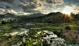
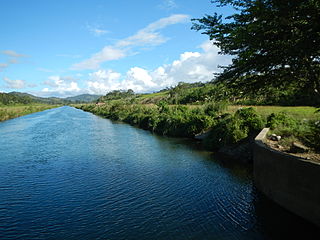
The Sibalom River is the longest river in the province of Antique in Panay island Philippines. With a total length of 73 kilometres (45 mi) and a drainage basin covering 682 square kilometres (263 sq mi), it is the largest river system in Antique and fourth longest in Panay after the Panay River, Jalaur River, and Aklan River. It is located in Sibalom and San Remigio. Along with its main tributaries the Mao-it River and Tipulu-an River, it forms the 5,511.47-hectare (13,619.1-acre) Tipulu-an and Mao-it River Watershed Forest Reserve which was proclaimed a natural park on April 23, 2000.
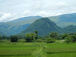
Mount Porras is a 1,378 feet mountain peak in the 5,511.47-hectare (13,619.1-acre) Tipulu-an Mau-it Rivers Watershed Forest Reserve, now known as Sibalom Natural Park. Sibalom Natural Park is located in the municipality of Sibalom, Antique, Panay Island, which was proclaimed a natural park on 23 April 2000.
Mount Igmatindog is a 3,281-foot (1,000 m) mountain peak in the 5,511.47-hectare (13,619.1-acre) Tipulu-an Mau-it Rivers Watershed Forest Reserve, now known as Sibalom Natural Park. Sibalom Natural Park is located in the municipality of Sibalom, Antique, Panay island, which was proclaimed a natural park on 23 April 2000.

The Angat Watershed Forest Reserve is a conservation area that protects the drainage basin in the southern Sierra Madre range north of Metro Manila in the Philippines where surface water empties into the Angat River and its distributaries. It is spread over an area of 62,309 hectares in the eastern portion of Bulacan and northern Rizal province at an altitude of between 490 and 1,206 metres. The conservation area also extends to the provinces of Nueva Ecija and Quezon and is centered on an artificial lake created by the Angat Dam which, together with the Ipo Dam located 7.5 kilometres (4.7 mi) downstream, supply 97% of the water requirement of Metro Manila via an aqueduct system to the La Mesa Dam and Reservoir and the Balara Filtration Plant in Quezon City. The Angat Dam and Reservoir is also a major source of hydroelectricity for Metro Manila and surrounding provinces, contributing some 200 megawatts to the Luzon grid. The watershed is a popular birdwatching site and is a biodiversity hotspot containing most of the remaining closed-canopy forests in Central Luzon.

The Pantabangan–Carranglan Watershed Forest Reserve is a conservation area located in the upper reaches of the Pampanga River in Nueva Ecija, Philippines, and borders the Sierra Madre and Caraballo Mountains in Aurora and Nueva Vizcaya. It encompasses 84,500 hectares of the drainage basin surrounding the Pantabangan Lake, an impoundment of the Pampanga River by the Pantabangan Dam. The multi-purpose dam is situated at the confluence of Pampanga River's two headwaters, namely the Pantabangan and Carranglan Rivers in the municipality of Pantabangan. It stretches above the dam site for 21 kilometres (13 mi) to where Carranglan River originates in the Caraballo on the north, and for 18 kilometres (11 mi) to where Pantabangan River originates in the Sierra Madre on the east. It is considered a critical watershed for the agricultural economy and hydroelectric power generation in the region of Central Luzon.

The Samar Island Natural Park, in Samar, is the largest contiguous tract of old-growth forest in the Philippines. It is the country's largest terrestrial protected area, with an area of 333,300 hectares. The buffer is spread north to south over the island's three provinces and totals 458,700 hectares, about a third of the entire island of Samar.
