
The Trans-Canada Highway is a transcontinental federal-provincial highway system that travels through all ten provinces of Canada from the Pacific Ocean on the west to the Atlantic on the east. The main route spans 7,821 km (4,860 mi) across the country, one of the longest routes of its type in the world. The highway system is recognizable by its distinctive white-on-green maple leaf route markers, although there are small variations in the markers in some provinces.

Cumberland County is a county in the Canadian province of Nova Scotia.

The Trans Canada Trail, officially renamed The Great Trail in September 2016, is a cross-Canada system of greenways, waterways, and roadways that stretches from the Atlantic to the Pacific to the Arctic oceans. The trail extends over 24,000 kilometres ; it is now the longest recreational, multi-use trail network in the world. The idea for the trail began in 1992, shortly after the Canada 125 celebrations. Since then it has been supported by donations from individuals, corporations, foundations, and all levels of government.

Oxford is a town in Cumberland County, Nova Scotia, Canada 32 km (20 mi) east of Amherst. The town is directly serviced by Routes 104, 204, 301, and 321. Despite its small size and demographic, Oxford is the world's largest processor and distributor of individually quick frozen (IQF) wild blueberries.
Highway 104 in Nova Scotia, Canada, runs from Fort Lawrence at the New Brunswick border near Amherst to River Tillard near St. Peter's. Except for the portion on Cape Breton Island between Port Hawkesbury and St. Peter's, it forms the main route of the Trans-Canada Highway across the province.
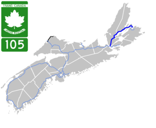
Highway 105 in Nova Scotia represents the Cape Breton Island leg of the Trans-Canada Highway. It runs from the Port Hastings Rotary just east of the Canso Causeway in Port Hastings to the Marine Atlantic ferry terminal in North Sydney, representing a distance of 142 kilometres (88 mi).
Nova Scotia Trunk 7 is part of the Canadian province of Nova Scotia's system of Trunk Highways. The route runs from Bedford to Antigonish, along the Eastern Shore for a distance of 269 kilometres (167 mi). Part of Trunk 7 is known as the Marine Drive.

Highway 142 is a 2-lane limited-access road in Cumberland County, Nova Scotia, Canada. It links Highway 104 at Exit 5 in Salt Springs Station to the town of Springhill. The 6-kilometre (4 mi) highway crosses the Canadian National Railway main line about 4.5 kilometres (2.8 mi) outside Springhill. There are several logging roads that have access onto the highway.

Trunk 1 is part of the Canadian province of Nova Scotia's system of Trunk Highways.
Trunk 2 is part of the Canadian province of Nova Scotia's system of Trunk Highways. The route runs from Halifax to Fort Lawrence on the New Brunswick border. Until the 1960s, Trunk 2 was the Halifax area's most important highway link to other provinces, and was part of a longer Interprovincial Highway 2 which ended in Windsor, Ontario. The controlled access Highway 102 and Highway 104 now carry most arterial traffic in the area, while Trunk 2 serves regional and local traffic.
Route 374 is a collector road in the Canadian province of Nova Scotia. It connects New Glasgow at Exit 24 of Nova Scotia Highway 104 with Sheet Harbour at Trunk 7. The highway runs through the Halifax Regional Municipality, Guysborough County & Pictou County.
Trunk 4 is part of the Canadian province of Nova Scotia's system of Trunk Highways. The route runs from Highway 104 exit 7 near Thomson Station to Glace Bay. Until the construction of the Trans-Canada Highway, Trunk 4 was a major traffic link in northern Nova Scotia and Cape Breton, and is still used on Cape Breton as an alternative to Highway 105. The highway was originally called the King's Highway, however, this name is no longer applied to the entire road. The only remaining historic section of the highway that maintains the name "King" is King's Road in Sydney.
Trunk 6 is part of the Canadian province of Nova Scotia's system of trunk highways. The route runs from Highway 104 exit 3 at Amherst to the rotary at Pictou, a distance of 136 kilometres (85 mi). It is part of the Sunrise Trail, a designated tourist route.
Trunk 19 is part of the Canadian province of Nova Scotia's system of trunk highways. The road runs from Port Hastings to a junction with the Cabot Trail at Margaree Forks on Cape Breton Island, a distance of 107 kilometres (66 mi). Most of the route is known as the Ceilidh Trail.
Route 970 is a 11.4-kilometre (7.1 mi) long provincial highway located entirely in Westmorland County, New Brunswick, Canada. The highway connects Nova Scotia Route 366 at Tidnish Bridge, Nova Scotia to Route 15 and Route 16 at Port Elgin. The road is one of only three public roads crossing the provincial boundary on the Isthmus of Chignecto; the other two being Route 2/Nova Scotia Highway 104 and the Mount Whately Road. It is the only land crossing between the two provinces.
Route 204 is a collector road in the Canadian province of Nova Scotia.
Route 366 is a collector road in the Canadian province of Nova Scotia.
Route 301 is a collector road in the Canadian province of Nova Scotia.
The River Philip is a river contained entirely within Cumberland County, Nova Scotia, Canada.


