Colchester County is a county in the Canadian province of Nova Scotia. With a population of 51,476 the county is the fourth largest in Nova Scotia. Colchester County is located in north central Nova Scotia.

Truro is a town in central Nova Scotia, Canada. Truro is the shire town of Colchester County and is located on the south side of the Salmon River floodplain, close to the river's mouth at the eastern end of Cobequid Bay.
George Isaac Smith MBE was a Canadian lawyer and politician who served as the 18th premier of Nova Scotia from 1967 to 1970. He was a Canadian senator from 1975 until his death. G.I. Smith is noted for having recruited Robert Stanfield to help rebuild and lead the Progressive Conservatives in Nova Scotia. While premier he brought Michelin Tire, still Nova Scotia's biggest employer, to the province. He established the Nova Scotia Human Rights Commission, and had the government take over Sydney Steel Corporation when its corporate owners quit the industry. His government also established the affordable housing community of Lower Sackville.
Highway 103 is an east-west highway in Nova Scotia that runs from Halifax to Yarmouth.
Highway 102 is a north–south highway in the Canadian province of Nova Scotia that runs from Halifax to Onslow, immediately north of the town of Truro. It is the busiest highway in Atlantic Canada.
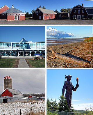
The Region of Queens Municipality is a regional municipality in southwestern Nova Scotia, Canada. It is the northern gateway of the UNESCO Southwest Nova Biosphere Reserve, a centre of outdoor activities. Campgrounds at Kejimukujik National Park and National Historic Site, Thomas H. Raddall Provincial Park, and several other locations offer hiking, biking, canoeing, kayaking, cross-country skiing and snowshoeing. Its seacoast and inland areas are popular photo locations.
Highway 104 in Nova Scotia, Canada, runs from Fort Lawrence at the New Brunswick border near Amherst to River Tillard near St. Peter's. Except for the portion on Cape Breton Island between Port Hawkesbury and St. Peter's, it forms the main route of the Trans-Canada Highway across the province.

Highway 107 in Nova Scotia runs through the eastern suburbs of the Halifax Regional Municipality, from the Bedford, Nova Scotia-Lower Sackville Border Line off Nova Scotia Highway 107 an intersection with Trunk 7 in Musquodoboit Harbour. It is 52.1 km (32.4 mi) long, and is mostly two lane, controlled access highway.

Trunk 2 is part of the Canadian province of Nova Scotia's system of Trunk Highways. The route runs from Halifax to Fort Lawrence on the New Brunswick border. Until the 1960s, Trunk 2 was the Halifax area's most important highway link to other provinces, and was part of a longer Interprovincial Highway 2 which ended in Windsor, Ontario. The controlled access Highway 102 and Highway 104 now carry most arterial traffic in the area, while Trunk 2 serves regional and local traffic.

Trunk 14 is part of the Canadian province of Nova Scotia's system of Trunk Highways. The route runs from Chester to Milford Station through the Windsor area, for a distance of 121 kilometres (75 mi).

Trunk 4 is part of the Canadian province of Nova Scotia's system of Trunk Highways. The route runs from Highway 104 exit 7 near Thomson Station to Glace Bay. Until the construction of the Trans-Canada Highway, Trunk 4 was a major traffic link in northern Nova Scotia and Cape Breton, and is still used on Cape Breton as an alternative to Highway 105. The highway was originally called the King's Highway, however, this name is no longer applied to the entire road. The only remaining historic section of the highway that maintains the name "King" is King's Road in Sydney.

The 100-Series highways are a series of arterial highways in the Canadian province of Nova Scotia.
Route 204 is a collector road in the Canadian province of Nova Scotia.
The Fundy Shore Ecotour is a former scenic drive and network of tourist destinations in the Canadian province of Nova Scotia and encircles several sub-basins of the Bay of Fundy, which contains the highest tidal range on the planet.
Route 215 is collector road in the Canadian province of Nova Scotia.
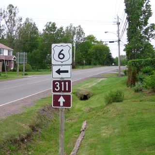
Route 311 is a collector road in the Canadian province of Nova Scotia.

The Bedford Highway is a highway in the Halifax Regional Municipality, Nova Scotia that is part of Trunk 2. It runs around the western side of the Bedford Basin. The highway starts at the Windsor Street intersection on the Halifax Peninsula and passes by the communities of Fairview, Rockingham, and Bedford, where it becomes part of Trunk 1 to Highway 101.
Aulac is a Canadian community in Westmorland County, New Brunswick. As of January 1, 2023 it is part of the Municipality of Tantramar which consists of the former town of Sackville, Village of Dorchester, Pointe de Bute and other rural communities. It is located between the former college town of Sackville and the provincial border with Nova Scotia.
Beaver Brook is a small community in the Canadian province of Nova Scotia, located in Colchester County. It is a mainly rural community with one small saw mill. Beaver Brook is located on the 236 Highway just west of the community of Old Barns. The "Beaver Brook" runs through the community's farm fields and finally into the Cobequid Bay at the headwaters of the Bay of Fundy.
Midland Railway was a Nova Scotian railway company formed in 1896 to build a railway through Hants County, Nova Scotia, connecting Truro to Windsor. Completed in 1901, it operated independently until 1905 when it became part of the Dominion Atlantic Railway and later the Canadian Pacific Railway, until the line closed in 1983.

