Hants County, Nova Scotia

Last updated

Hants County
HantsCounty.png
Location of Hants County, Nova Scotia
Coordinates: 45°06′N63°54′W / 45.100°N 63.900°W / 45.100; -63.900 Coordinates: 45°06′N63°54′W / 45.100°N 63.900°W / 45.100; -63.900
CountryCanada
Province Nova Scotia
Municipalities East Hants / West Hants Regional Municipality
EstablishedJune 17, 1781
Divided into District MunicipalitiesApril 17, 1879
Electoral districts
Federal

Kings—Hants
Provincial Hants East / Hants West
Area
[1]
  Land3,049.08 km2 (1,177.26 sq mi)
Population
 (2006) [1] [2]
  Total41,182
  Density13.5/km2 (35/sq mi)
  Change 2001-06
Increase2.svg1.7%
   Census  Rankings
- District municipalities
East Hants
West Hants
- Towns
Hantsport
  Windsor
 - Reserves
Indian Brook 14


21,387 (179 of 5,008)
13,881 (272 of 5,008)

1,191 (1,839 of 5,008)
3,709 (862 of 5,008)

1,014 (2,039 of 5,008)
Time zone UTC−04:00 (AST)
  Summer (DST) UTC−03:00 (ADT)
Area code 902
Dwellings17,277
Median Income*$49,630
  • Median household income, 2005 (all households)

Hants County is an historical county and census division of Nova Scotia, Canada. Local government is provided by the West Hants Regional Municipality, and the Municipality of the District of East Hants.

Contents

History

Formation

The county of Hants was established June 17, 1781, on territory taken from Kings County and consisted of the townships of Windsor, Falmouth and Newport. [3] The name Hants is an old abbreviation for the English county of Hampshire, from the Old English name Hantescire. In 1861, Hants County was divided for court sessional purposes into two districts named East Hants and West Hants. In 1879, the two districts were incorporated as district municipalities. In 2020, the Town of Windsor amalgamated with the District of West Hants to become the West Hants Regional Municipality. [4]

18th century - origins

Miꞌkmaq

Monument to the Treaty of 1752, Shubenacadie First Nation, Nova Scotia MonumentPeaceTreaty1752.jpg
Monument to the Treaty of 1752, Shubenacadie First Nation, Nova Scotia

The Miꞌkmaq are the indigenous peoples who lived on these lands for centuries. In the course of their historical relationship with the Acadians, many Miꞌkmaq became Catholic and therefore played an active role in the Acadian resistance to the Protestant British annexation of Hants County. They were clearly supporters of Abbe LeLoutre's work in protecting Acadian and Miꞌkmaq and ultimately Catholic interests in the region. Within Hants County, they fought in the Battle at St. Croix on the St. Croix River.

There is a long history of missionary work in Hants County, such as the work of Silas Tertius Rand's work on Glooscap First Nation near Hantsport. There are still Miꞌkmaq communities in Hants County such as Indian Brook 14 (the home of the famous activist Anna Mae Aquash) and Shubenacadie 13. Shubenacadie is the oldest community in Hants County. There is a significant monument in the middle of the reserve to Major Jean-Baptiste Cope, the signatory to the peace Treaty of 1752 with the British, which was recently upheld by the Supreme Court of Canada (1985).

Acadians

Fort Edward (built 1750). The oldest blockhouse in North America. FortEdwardWindsorNovaScotiaCanada.JPG
Fort Edward (built 1750). The oldest blockhouse in North America.

The first Acadians to settle in present-day Hants County (known as Pisiguit) established farms at (present day Falmouth) in the early 1680s, as the 1686 census shows a number of families on well established farms utilizing dyked pastures. More Acadian villages soon followed spreading along the shores of the Piziquid and St. Croix rivers. One of these was at present day Windsor. With an expanding population the region by 1722 was split into two parishes (see Pisiquit). The l'Assomption parish church was situated on a hill overlooking the confluence of the Pisiquit and Saint Croix rivers where in 1750 it was pulled down by the Acadians under orders from the British to make way for Fort Edward. By the early 1700s Acadians migrated all along the shore of Hants County to the Shubenacadie River. One of the most prominent Acadians from this area was Noël Doiron who is the namesake of the community of Noel. With the founding of both Halifax (1749) and Fort Edward, there was an Acadian Exodus that involved an emigration of most of the Acadians from the Municipality of East Hants (1750) and from West Hants (Pisiguit) as well. They left British Nova Scotia for French occupied Prince Edward Island. [5] During the 1755 Expulsion of the Acadians the majority of those Acadians remaining were deported to various locations along the eastern seaboard of the Thirteen Colonies, most notably New England and Maryland. The Expulsion of the Acadians from Hants County began at exactly the same time as it happened at Grand-Pré, with the Acadian men being imprisoned within the walls of Fort Edward. Fort Edward was one of four British forts in Acadia to imprison Acadians throughout the nine years of the expulsion.

New England Planters

Hants County Township Map, 1879 HantsCountyTownshipMap1879.jpg
Hants County Township Map, 1879

After the Acadians were removed from the area of present-day Hants County, New England Planters began to arrive and settle the vacated lands (1760). They formed the townships of Windsor, Falmouth and Newport. Many arrived from Rhode Island. [6] One of the Planters of note during this period was Henry Alline who led the New Light revival of the Great Awakening in the region. Alline's movement had a significant impact on the stance the New Englander Planters took with respect to the troubles building in the colonies to the west, between their British masters, and brethren who remained in New England, that led to the Revolutionary War. Alline's Newlight congregations were the progenitors of the Baptist movement in Canada. [7] [8] [9]

Ulster Irish

The next wave of immigration to Hants County was the Ulster Scots people who settled all along the Cobequid shore such as the O'Briens in Noel (1771) and the Putnams in Maitland.

American Loyalists

During the American Revolution, Fort Edward played a pivotal role defending Halifax from a possible land attack and serving as the headquarters in Atlantic Canada for 84th Regiment of Foot (Royal Highland Emigrants). After the American Revolution, the Rawdon Township and Douglas Township were created for American Loyalists (1884). The Douglas Township (Kennetcook and area) was settled by the 84th Regiment of Foot. The Rawdon Township was settled by loyalists from South Carolina whose lives had been saved in the Siege of Ninety-Six by Lord Rawdon and the 84th Regiment of Foot.

19th century - shipbuilding and confederation

Plaster War

Windsor developed its gypsum deposits, usually selling it to American markets at Passamaquoddy Bay. Often this trade was illegal. In 1820 an effort to stop this smuggling trade resulted in the "Plaster War", in which local smugglers resoundingly defeated the efforts of New Brunswick officials to bring the trade under their control. [10]

Shipbuilding

Productive timber lands and tidal building sites made Hants County an important shipbuilding centre in the 19th century. Loyalist merchant Abraham Cunard was an early shipbuilder in the county. Cunard's efforts were surpassed by much larger yards by the mid 19th century, including the William Dawson Lawrence shipyard in Maitland which built the William D. Lawrence , the largest wooden ship ever built in Canada, and Ezra Churchill's in Hantsport.

The Great Hants Campaign (1869)

Joseph Howe, MP for Hants County Joehowe.JPG
Joseph Howe, MP for Hants County

The Honourable Joseph Howe was the first member of parliament for Hants County (1867). [11] He campaigned in the county with an agenda to punish those politicians who have forced Nova Scotia to participate in the formation, and become a part of Canada without a mandate or referendum from the people. Over the next two years in office, deciding not to mobilize to join America or become a colony independent of Britain, Howe determined that Nova Scotia's best option was to remain in Canada and to fight for "better terms. While most Nova Scotians remained supportive of the Anti-Confederation Campaign during this time period, Howe ran in Hants County bi-election of 1869 to get a mandate from the people to see if they wanted him to continue to support Nova Scotia's entry into Canada. What ensued was one of the most expensive political campaigns in Nova Scotia's history. [11] The whole country watched to see if Howe would be returned to Ottawa to lead Nova Scotia into Confederation on the best terms possible. Howe toured the whole county and eventually won, which eventually led to all of Nova Scotia accepting Canada. [12]

20th century

Hants County produced two Olympians, both of whom came from along the Noel shore (see Athletics at the 1928 Summer Olympics – Men's marathon). Along with the great literary figure in Nova Scotia's history, Thomas Chandler Haliburton, Hants produced Alden Nowlan, George Elliott Clarke and others. The celebrated folk artist Sidney Kelsie who later made his career in Edmonton, Alberta was born in Hants County in 1928. Folk singer Stan Rogers made the community of Rawdon famous by writing the song "The Rawdon Hills".

Natural resources: wood, fish, gypsum, barite, oil and gold

The wood in the county was both used to build the many wooden ships, but it was also used as an export resource on the wooden ships. For this purpose, the Midland Railway was also built through the County (1901), connecting Windsor and Truro.

The county is noted for very large deposits of gypsum, some of which was at one time shipped from Walton. The world's largest open pit gypsum mine is located in Milford, East Hants and currently produces approximately 8,000 tons of gypsum daily. George Elliot Clarke's poem, "West Hants County", tells of the difficult condition of black workers in the gypsum mines.

Barite was also an extremely important ore to Hants County. The largest barite mine in the world was in Walton and that; combined with the gypsum and lumbering, made Walton the second busiest port in Nova Scotia in the 1950s. The mine produced in total 4.5 million tonnes of barite, between 1941 and 1978. Silver, lead, zinc and copper were also found in the same mine and over 360,000 tonnes were mined. It is estimated that there are still about 1 million tonnes of barite left in the deposit.

Gold was mined at Renfrew, near Nine Mile River, The village was the home of one of the largest gold mines in the province. There were other gold mines in the community of Rawdon Gold Mines. There is currently oil exploration in and around Kennetcook.

Communities

Towns
Reserves
Municipalities

Demographics

As a census division in the 2021 Census of Population conducted by Statistics Canada, Hants County had a population of 45,140 living in 18,862 of its 20,306 total private dwellings, a change of

Access routes

Highways and numbered routes that run through the county, including external routes that start or finish at the county limits: [18]

Notable residents

See also

Related Research Articles

Windsor is a community located in Hants County, Nova Scotia, Canada. It is a service centre for the western part of the county and is situated on Highway 101.

<span class="mw-page-title-main">Minas Basin</span> Body of water

The Minas Basin is an inlet of the Bay of Fundy and a sub-basin of the Fundy Basin located in Nova Scotia, Canada. It is known for its extremely high tides.

<span class="mw-page-title-main">Municipality of the District of East Hants</span> District municipality in Nova Scotia, Canada

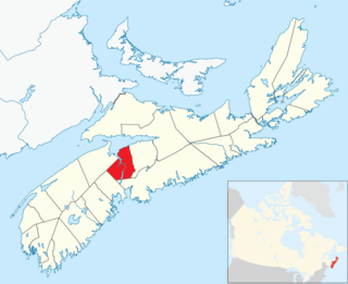
East Hants, officially named the Municipality of the District of East Hants, is a district municipality in Hants County, Nova Scotia, Canada. Statistics Canada classifies the district municipality as a municipal district.

Hantsport is an unincorporated area in the West Hants Regional Municipality, Nova Scotia, Canada. It is at the western boundary between West Hants Regional Municipality and Kings County, along the west bank of the Avon River's tidal estuary. The community is best known for its former industries, including shipbuilding, a pulp mill, as well a marine terminal that once loaded gypsum, mined near Windsor. The community is the resting place of Victoria Cross recipient William Hall.

<span class="mw-page-title-main">Ezra Churchill</span> Canadian politician

Ezra Churchill : Nineteenth-century industrialist, investing in shipbuilding, land, timber for domestic and foreign markets, gypsum quarries, insurance companies, hotels, etc. As a politician he held positions in the Nova Scotia legislature and was appointed a Canadian Senator for the Province of Nova Scotia. Churchill was also a Baptist lay preacher.

<span class="mw-page-title-main">West Hants Regional Municipality</span> Regional municipality in Nova Scotia, Canada

West Hants, officially named the West Hants Regional Municipality, is a regional municipality in Hants County, Nova Scotia, Canada.

<span class="mw-page-title-main">New England Planters</span> Settlers from New England who moved to Nova Scotia

The New England Planters were settlers from the New England colonies who responded to invitations by the lieutenant governor of Nova Scotia, Charles Lawrence, to settle lands left vacant by the Bay of Fundy Campaign (1755) of the Acadian Expulsion.

<span class="mw-page-title-main">84th Regiment of Foot (Royal Highland Emigrants)</span> Military unit

The 84th Regiment of Foot was a British regiment in the American Revolutionary War that was raised to defend present day Ontario, Quebec and Atlantic Canada from the constant land and sea attacks by American Revolutionaries. The 84th Regiment was also involved in offensive action in the Thirteen Colonies; including North Carolina, South Carolina, Georgia, Virginia and what is now Maine, as well as raids upon Lake Champlain and the Mohawk Valley. The regiment consisted of 2,000 men in twenty companies. The 84th Regiment was raised from Scottish soldiers who had served in the Seven Years' War and stayed in North America. As a result, the 84th Regiment had one of the oldest and most experienced officer corps of any regiment in North America. The Scottish Highland regiments were a key element of the British Army in the American Revolution. The 84th Regiment was clothed, armed and accoutred the same as the Black Watch, with Lieutenant Colonel Allan Maclean commanding the first battalion and Major General John Small of Strathardle commanding the second. The two Battalions operated independently of each other and saw little action together.

<span class="mw-page-title-main">Burntcoat Head, Nova Scotia</span> Human settlement in Nova Scotia, Canada

Burntcoat Head is an unincorporated rural Canadian community in Hants County, Nova Scotia. The area is known for having the largest tidal range of any location in the world.

<span class="mw-page-title-main">Walton, Nova Scotia</span> Village in Nova Scotia, Canada

Walton is a village in the Canadian province of Nova Scotia, located in the Municipal District of East Hants, Nova Scotia. The community is named after John Nutting's son James Walton Nutting.

Kennetcook is a community in the Canadian province of Nova Scotia, located in the Municipal District of East Hants. Also see adjacent community of Upper Kennetcook.

Rawdon is a former township in the Canadian province of Nova Scotia. The township was the eventual destination of Loyalists fleeing the Siege of Ninety Six during the American Revolutionary War. In 1861, along with the township of Douglas, Nova Scotia, the Rawdon township became part of the newly-formed Municipal District of East Hants, along with neighbouring townships.

St. Croix is a community in the province of Nova Scotia Canada, located in Hants County, Nova Scotia.

Scotch Village is an unincorporated community on the Kennetcook River in the Canadian province of Nova Scotia, located in the Municipality of West Hants. This area was part of Newport Township at the time of settlement primarily by Rhode Island Planters in the early 1760s. It was referred to as “Scotchman’s Dyke” or “Scotch Village”, due to settlement of early families of Scottish descent. Prior to the arrival of the Planters, Scotch Village had been the home of Mi'kmaq and Acadians.

Mount Denson is a small community in the Canadian province of Nova Scotia, located in The Municipality of the District of West Hants in Hants County. The community is named after Mount Denson; the mid-eighteenth-century estate of Henry Denny Denson.

Summerville is a small community in the Canadian province of Nova Scotia, located in The Municipality of the District of West Hants in Hants County. As of 2015, the population of Summerville was estimated to be 248.

Selma is a small community in the Canadian province of Nova Scotia, located in The Municipality of the District of East Hants in Hants County.

Midland Railway was a Nova Scotian railway company formed in 1896 to build a railway through Hants County, Nova Scotia, connecting Truro to Windsor. Completed in 1901, it operated independently until 1905 when it became part of the Dominion Atlantic Railway and later the Canadian Pacific Railway, until the line closed in 1983.

<span class="mw-page-title-main">Hantsport station</span> Railway station in Nova Scotia, Canada

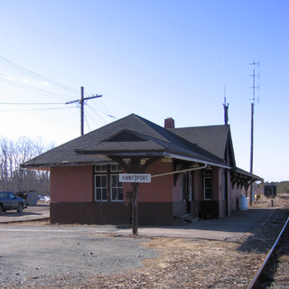
Hantsport station in Hantsport, Nova Scotia, Canada, was built in 1944 as a replacement for an earlier station destroyed by fire in 1943. The brick Tudor revival station was designed by Canadian Pacific Railway architects. The station played an important role in controlling the large shipments of gypsum through the port of Hantsport by the Dominion Atlantic Railway and later the Windsor and Hantsport Railway until 2011 when the gypsum mines around Windsor closed. The station is protected by both federal and provincial heritage laws. It was designated a historic railway station by the federal government in 1992 and as a provincial heritage building in 1995.

References

  1. 1 2 2006 Statistics Canada Community Profile: Hants County, Nova Scotia
  2. Statistics Canada Population and dwelling counts, for Canada and census subdivisions (municipalities), 2006 and 2001 censuses - 100% data
  3. The words of the minutes of the Council of Nova Scotia for June 17, 1781 make it clear that the distance from Horton (the County town of Kings County) and the inconvenience of crossing the Avon River to transact county business were factors which led to a separate county being formed. Four and a half years later its boundaries were more precisely defined and set forth by the Governor and Council in 1785. The boundary lines of Hants were duly surveyed and confirmed by the Lieutenant Governor 1828.
  4. Thompson, Ashley. "How council landed on the new name West Hants Regional Municipality". www.saltwire.com. Saltwire. Retrieved 28 July 2021.
  5. Patterson, Stephen E. (1994). "1744–1763: Colonial Wars and Aboriginal Peoples". In Phillip Buckner; John G. Reid (eds.). The Atlantic Region to Confederation: A History. University of Toronto Press. p. 141. ISBN   978-1-4875-1676-5. JSTOR   10.3138/j.ctt15jjfrm.
  6. Rhode Island Settlers in Nova Scotia
  7. Beverley, James and Barry Moody, Editors. The Journal of Henry Alline. Lancelot Press for the Acadia Divinity School and the Baptist Historical Committee. 1982.
  8. Bumsted, J. M. Henry Alline. Lancelot Press, Hantsport, 1984.
  9. Rawlyk, George. The Sermons of Henry Alline. Lancelot Press for Acadia Divinity College and The Baptist Historical Committee of the United Baptist Convention of the Atlantic Provinces. 1986.
  10. Smith, Joshua (2007). Borderland Smuggling: Patriots, Loyalists, and Illicit Trade in the Northeast, 1780-1820. Gainesville, FL: UPF. pp. passim. ISBN   0-8130-2986-4.
  11. 1 2 Joseph Howe: The Briton Becomes Canadian, 1848-1873 By J. Murray Beck
  12. Joseph Schull. "The Night They Killed Joe Howe" Ottawa Citizen - Jun 30, 1956
  13. "Population and dwelling counts: Canada and census divisions". Statistics Canada. 9 February 2022. Retrieved 2 April 2022.
  14. Censuses 1871-1941
  15. Statistics Canada: 1996, 2001, 2006 census
  16. Statistics Canada: 2011 census
  17. 2006 Statistics Canada Census Ethnocultural Portrait of Canada: Hants County, Nova Scotia
  18. Atlantic Canada Back Road Atlas ISBN   978-1-55368-618-7 Pages 67-68, 80-81