Municipality of the District of Shelburne

Last updated

District of Shelburne
Municipality of the District of Shelburne
Municipality of Shelburne NS Shield.png
Motto: 
From Ocean To Forest
Shelburne Municipal District - Nova Scotia.PNG
Location of the Municipality of the District of Shelburne
Coordinates: 43°51′00″N65°16′58″W / 43.85°N 65.282778°W / 43.85; -65.282778
CountryCanada
Province Nova Scotia
County Shelburne
IncorporatedApril 17, 1879
Electoral Districts        
Federal

South Shore—St. Margaret's
Provincial Shelburne
Government
  TypeCouncil of the Municipality
of the District of Shelburne
  WardenPenny Smith
Area
[1]
  Land1,816.71 km2 (701.44 sq mi)
Population
 (2021) [1]
  Total4,336
  Density2.4/km2 (6/sq mi)
  Change 2016-21
Increase2.svg1.1%
Time zone UTC-4 (AST)
  Summer (DST) UTC-3 (ADT)
Dwellings2735
Median Income*$40,415 CDN
Seat Shelburne, Nova Scotia
Website Official website
  • Median household income, 2005 (all households)

District of Shelburne, officially named the Municipality of the District of Shelburne, is a district municipality comprising the eastern section of Shelburne County, Nova Scotia, Canada, but does not include the Towns of Shelburne or Lockeport. Statistics Canada classifies the district municipality as a municipal district. It is home to the Bowers Meadows Wilderness Area. [2]

Contents

Demographics

Historical population
YearPop.±%
19815,359    
19865,365+0.1%
19915,450+1.6%
1996 5,315−2.5%
2001 4,925−7.3%
2006 4,828−2.0%
2011 4,408−8.7%
2016 4,288−2.7%
2021 4,336+1.1%
Source: Statistics Canada [3] [4]

In the 2021 Census of Population conducted by Statistics Canada, the Municipality of the District of Shelburne had a population of 4,336 living in 2,059 of its 2,735 total private dwellings, a change of

Communities

The following communities are included within the Municipality of the District of Shelburne:

Access routes

Highways and numbered routes that run through the district municipality, including external routes that start or finish at the municipal boundary: [7]

See also

Related Research Articles

<span class="mw-page-title-main">Shelburne County, Nova Scotia</span> County in Nova Scotia, Canada

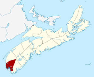
Shelburne County is a county in the Canadian province of Nova Scotia.

<span class="mw-page-title-main">Yarmouth County</span> County in Nova Scotia, Canada

Yarmouth County is a rural county in the Canadian province of Nova Scotia. It has both traditional Anglo-Scottish and Acadian French culture as well as significant inland wilderness areas, including over 365 lakes and several major rivers. It comprises three municipalities: the Town of Yarmouth, the Municipality of the District of Yarmouth, and the Municipality of the District of Argyle.

<span class="mw-page-title-main">Halifax, Nova Scotia</span> Capital and most populous municipality of Nova Scotia, Canada

Halifax is the capital and largest municipality of the Canadian province of Nova Scotia, and the largest municipality in Atlantic Canada. As of 2022, it is estimated that the population of the Halifax CMA was 480,582, with 348,634 people in its urban area. The regional municipality consists of four former municipalities that were amalgamated in 1996: Halifax, Dartmouth, Bedford, and Halifax County.

<span class="mw-page-title-main">Shelburne, Nova Scotia</span> Town in Nova Scotia, Canada

Shelburne is a town located in southwestern Nova Scotia, Canada.

<span class="mw-page-title-main">Municipality of the District of Barrington</span> District municipality in Nova Scotia, Canada

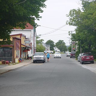
Barrington, officially named the Municipality of the District of Barrington, is a district municipality in western Shelburne County, Nova Scotia, Canada. Statistics Canada classifies the district municipality as a municipal district.

<span class="mw-page-title-main">Clark's Harbour</span> Town in Nova Scotia, Canada

Clark's Harbour is a town on Cape Sable Island in southwestern Nova Scotia, Canada, located in Shelburne County. The main industry is lobster fishing. Owing to this as well as the town's history as a fishing community, the town is noted as the birthplace of the Cape Islander fishing boat.

<span class="mw-page-title-main">Lockeport</span> Town in Nova Scotia, Canada

Lockeport is a town and port in Shelburne County, Nova Scotia, Canada. It is a traditional Nova Scotian fishing town, situated on a peninsula in Allendale Bay. It is connected to the mainland by the Crescent Beach causeway. The area that surrounds the bay is known as the "Ragged Islands."

The Tri-County Regional School Board (TCRSB) is the public school board responsible for 23 elementary, junior high, and high schools in Digby County, Yarmouth County, and Shelburne County in Nova Scotia, Canada.

The Lighthouse Route is a scenic roadway in the Canadian province of Nova Scotia. It follows the province's South Shore for 585 km (364 mi) from Halifax to Yarmouth.

<span class="mw-page-title-main">Jordan Falls, Nova Scotia</span>

Jordan Falls is a community of the Municipality of the District of Shelburne in the Canadian province of Nova Scotia on Nova Scotia Trunk 3 and Highway 103.

Port La Tour is a community in the Canadian province of Nova Scotia, located in the Municipality of the District of Barrington of Shelburne County.

Eel Bay, previously known as Cape Negro, is a community in the Canadian province of Nova Scotia, located in the Municipality of the District of Barrington of Shelburne County. Cape Sable, Nova Scotia By one account, Eel Bay was first settled by the French who migrated from Port Royal, Nova Scotia in 1720. However other records indicate the habitation and garden of a French Priest at the Hawl Over in Eel Bay as early as 1635, and the 1671 French census records the family of Amand and Elizabeth Lalloue living in Eel Bay.

Port Clyde is a community in the Canadian province of Nova Scotia, located in the Shelburne Municipal District of Shelburne County.

Villagedale is a community in the Canadian province of Nova Scotia, located in the Municipality of the District of Barrington of Shelburne County.

Port L'Hebert is a community of the Municipality of the District of Shelburne in the Canadian province of Nova Scotia.

<span class="mw-page-title-main">Outline of Nova Scotia</span> Overview of and topical guide to Nova Scotia

The following outline is provided as an overview of and topical guide to Nova Scotia:

<span class="mw-page-title-main">Administrative divisions of Nova Scotia</span> Local governance within Nova Scotia

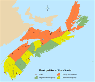
The Canadian province of Nova Scotia is divided into 49 municipalities, of which there are three types: regional (4), town (25), and county or district municipality (20).

References

  1. 1 2 Statistics Canada Census Profile, 2021 Census of Population – 100% data
  2. Environment, Nova Scotia (1 April 2009). "Bowers Meadows Wilderness Area - Protected Areas - Nova Scotia Environment". novascotia.ca.
  3. 1996, 2001, 2006 census
  4. 1 2 "Population and dwelling counts: Canada, provinces and territories, census divisions and census subdivisions (municipalities), Nova Scotia". Statistics Canada. February 9, 2022. Retrieved March 12, 2022.
  5. 2006 Statistics Canada Community Profile: Shelburne Municipal District, Nova Scotia
  6. 2006 Statistics Canada Census Topic-Based Tabulations: Shelburne Municipal District, Nova Scotia
  7. Atlantic Canada Back Road Atlas ISBN   978-1-55368-618-7 Page 89

43°51′00″N65°16′58″W / 43.85000°N 65.28278°W / 43.85000; -65.28278