Aylesford, Nova Scotia

Last updated

Aylesford
Canada Nova Scotia location map 2.svg
Red pog.svg
Aylesford
Location of Aylesford, Nova Scotia
Coordinates: 45°02′0″N64°50′00″W / 45.03333°N 64.83333°W / 45.03333; -64.83333
CountryFlag of Canada (Pantone).svg  Canada
ProvinceFlag of Nova Scotia.svg  Nova Scotia
County Kings
Electoral Districts     
Federal

West Nova
Provincial Kings West
Elevation
32 m (105 ft)
Population
 (2011) [1]
  Total834
Time zone UTC-4 (AST)
  Summer (DST) UTC-3 (ADT)
Canadian Postal code
B0P 1C0
Area code 902 782
Telephone Exchange 847
NTS Map021H02
GNBC CodeCABCE

Aylesford, since its formation, has always been a farming community. It is situated in western Kings County in the Annapolis Valley of Nova Scotia, Canada. The settlement was named after the fourth Earl of Aylesford, Heneage Finch, who was Lord Of The Bedchamber to George III from 1772-1777. [2] The community is located between the North and South Mountains, and is roughly a 15 minute drive to Canadian Forces Base Greenwood, and a 10 minute drive to its closest neighbour, the Town Of Berwick. Aylesford is located on the Evangeline Trail (Trunk 1) scenic tourist route, which was named after the epic 1847 H.W. Longfellow poem entitled Evangeline, A Tale of Acadie .

Contents

History

Aylesford Cenotaph AylesfordCenotaph.jpg
Aylesford Cenotaph

Aylesford is one of the oldest surviving settlements in Kings County, originally settled by Ulster Scots (Scots-Irish) during the early 1770s. Between 1772 and 1781, the population of Nova Scotia actually fell - from 19,000 to 12,000 - but by 1784, after the continued arrival of United Empire Loyalists during the American Revolution, the population had reached 32,000. A number of Loyalists, aka "The King’s Loyal Americans" put down roots in Aylesford and the surrounding area. Aylesford emerged as a major centre for packing, processing and exporting apples after the arrival of the Windsor and Annapolis Railway in 1869.

Demographics

In the 2021 Census of Population conducted by Statistics Canada, Aylesford had a population of 834 living in 399 of its 428 total private dwellings, a change of

Economy

Aylesford's economy relies primarily on the local agricultural industry. It is a service centre for the surrounding agricultural district. An important crop is cranberries cultivated on the extensive peat bogs. Peat moss harvesting operations are also active.

Aylesford's largest tourist attraction, the Oaklawn Farm Zoo (located just outside the village in Millville), was home to Rutledge, the heaviest living lion in captivity, as certified by Guinness World Records in 1997. Rutledge died in February 2009, three months short of his 18th birthday. [4] The zoo also has a variety of other animals including tigers, dromedary camels, and a variety of monkeys. Other attractions in Aylesford include a public beach at Aylesford Lake, Crystal Falls hiking trail, and Clairemont Provincial park.

A farm called Dempsey's Corner has a fee-based self-pick service for fruits and vegetables. They also have a petting zoo and educate their visitors on the history of farming. Many other area farms provide a self-pick service offering strawberries, apples, pears, cherries, blueberries, raspberries, peaches and other produce. [5]

There is also an Elementary School, St. Mary's Elementary (grades from primary to 5), along with West Kings District High School (grades 9-12). The Middle School youth attend Pine Ridge Middle School in neighbouring Kingston.

There is a thriving Scouting group in Aylesford, 1st Aylesford Scouting, which is about to celebrate its 100th Anniversary in 2024.

Notable residents

Related Research Articles

<span class="mw-page-title-main">Annapolis Valley</span> Economic region in Nova Scotia, Canada

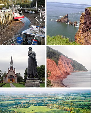
The Annapolis Valley is a valley and region in the province of Nova Scotia, Canada. It is located in the western part of the Nova Scotia peninsula, formed by a trough between two parallel mountain ranges along the shore of the Bay of Fundy. Statistics Canada defines the Annapolis Valley as an economic region, composed of Annapolis County, Kings County, and Hants County.

<span class="mw-page-title-main">Kings County, Nova Scotia</span> County in Nova Scotia, Canada

Kings County is a county in the Canadian province of Nova Scotia. With a population of 62,914 in the 2021 Census, Kings County is the third most populous county in the province. It is located in central Nova Scotia on the shore of the Bay of Fundy, with its northeastern part forming the western shore of the Minas Basin.

<span class="mw-page-title-main">Middleton, Nova Scotia</span> Town in Nova Scotia, Canada

Middleton is a town in Annapolis County, Nova Scotia, Canada. Situated on the north bank of the Annapolis River, it is located close to the centre of the Annapolis Valley, from which it gets its nickname, "The Heart of the Valley".

<span class="mw-page-title-main">Annapolis (provincial electoral district)</span> Provincial electoral district in Nova Scotia, Canada

Annapolis is a provincial electoral district in Nova Scotia, Canada, that elects one member of the Nova Scotia House of Assembly.

<span class="mw-page-title-main">Grand-Pré, Nova Scotia</span> Community in Nova Scotia, Canada

Grand-Pré is a Canadian rural community in Kings County, Nova Scotia. Its French name translates to "Great/Large Meadow" and the community lies at the eastern edge of the Annapolis Valley several kilometres east of the town of Wolfville on a peninsula jutting into the Minas Basin surrounded by extensive dyked farm fields, framed by the Gaspereau and Cornwallis Rivers. The community was made famous by Henry Wadsworth Longfellow's poem Evangeline and is today home to the Grand-Pré National Historic Site. On June 30, 2012, the Landscape of Grand-Pré was named a World Heritage Site by UNESCO.

<span class="mw-page-title-main">Annapolis River</span> River in Nova Scotia, Canada

The Annapolis River is a Canadian river located in Nova Scotia's Annapolis Valley.

<span class="mw-page-title-main">New England Planters</span> Settlers from New England who moved to Nova Scotia

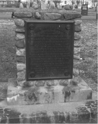
The New England Planters were settlers from the New England colonies who responded to invitations by the lieutenant governor of Nova Scotia, Charles Lawrence, to settle lands left vacant by the Bay of Fundy Campaign (1755) of the Acadian Expulsion.

<span class="mw-page-title-main">Nova Scotia Trunk 1</span> Highway in Nova Scotia

Trunk 1 is part of the Canadian province of Nova Scotia's system of Trunk Highways.

<span class="mw-page-title-main">Berwick, Nova Scotia</span> Town in Nova Scotia, Canada

Berwick is a Canadian town in Kings County, Nova Scotia. The town is located in the eastern part of the Annapolis Valley on the Cornwallis River. The town site stretches south from the river and Exit 15 of Highway 101 to Highway 1. Berwick occupies 6.80 km2 and has an elevation of 43 m (141 ft) above sea level.

Cambridge is a community on the Cornwallis River in Kings County, Nova Scotia, Canada, located 12 kilometres west of Kentville. It is administratively part of the village of Cornwallis Square. According to one source, the community was named after Cambridge, England. while another holds it was named for Cambridge, Massachusetts.

The Evangeline Trail is a scenic roadway in the Canadian province of Nova Scotia.

<span class="mw-page-title-main">Oaklawn Farm Zoo</span> Zoo in Nova Scotia, Canada

The Oaklawn Farm Zoo is a zoo located in Millville, Nova Scotia, Canada, just south of the village of Aylesford. It was opened in 1984, and is family-owned and operated by Ron and Gail Rogerson. The zoo boasts the largest display of Big Cats and Primates in Eastern Canada. The 50-acre (20 ha) zoo is in a rural setting in Nova Scotia's Annapolis Valley, and includes a wide diversity of mammals, birds and reptiles.

<span class="mw-page-title-main">Cornwallis River</span> River in Nova Scotia, Canada

The Cornwallis River is in Kings County, Nova Scotia, Canada. It has a meander length of approximately 48 kilometres (30 mi) through eastern Kings County, from its source on the North Mountain at Grafton to its mouth near Wolfville on the Minas Basin. The lower portion of the river beginning at Kentville is tidal and there are extensive tidal marshes in the lower reaches. In its upper watershed at Berwick, the river draws on the Caribou Bog while a longer branch continues to the official source, a stream on the North Mountain at Grafton.

Hall's Harbour is a fishing community in the Canadian province of Nova Scotia, located in Kings County on the North Mountain along the shore of the Bay of Fundy.

Wilmot is an unincorporated community located in Annapolis County in the Canadian province of Nova Scotia.

<span class="mw-page-title-main">Leslie R. Fairn</span> Canadian architect (1875–1971)

Leslie Raymond Fairn was a Canadian architect whose career is notable for its longevity and for the range of styles it encompassed, including Beaux Arts and Modernism. Most of his work was completed in the Maritimes.

<span class="mw-page-title-main">Emma Stirling</span>

Emma Maitland Stirling was a British activist in child welfare and in arranging their emigration to Canada. She created the organisation that became the Scottish Society for the Prevention of Cruelty to Children, but her contribution was not acknowledged in their history.

<span class="mw-page-title-main">Township (Nova Scotia)</span> Former division of Nova Scotia

A township in Nova Scotia, Canada, was an early form of land division and local administration during British colonial settlement in the 18th century. They were created as a means of populating the colony with people loyal to British rule. They were typically rural or wilderness areas of around 100,000 acres (400 km2) that would eventually include several villages or towns. Some townships, but not all, returned a member to the General Assembly of Nova Scotia; others were represented by the members from the county. Townships became obsolete by 1879 by which time towns and counties had become incorporated.

<span class="mw-page-title-main">Samuel Bayard</span>

Lieutenant Colonel Samuel Vetch Bayard was a Loyalist military officer in the American Revolution who served in the King's Orange Rangers (KOR). He is the son of William Bayard who founded the KOR. He was the great-grandson of Governor Samuel Vetch and was the father of Robert Bayard.

<span class="mw-page-title-main">Administrative divisions of Nova Scotia</span> Local governance within Nova Scotia

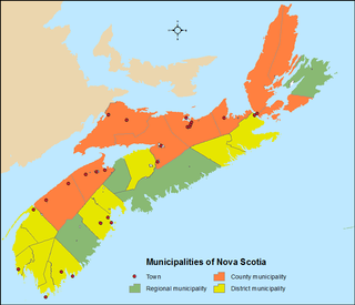
The Canadian province of Nova Scotia is divided into 49 municipalities, of which there are three types: regional (4), town (25), and county or district municipality (20).

References

  1. "Browse Data by Community Profile, 2011 and 2006 censuses (Nova Scotia)". Government of Nova Scotia. December 18, 2012. Retrieved January 29, 2013.
  2. Echoes across the Valley, A History of Kingston and its Neighbors, Tony Cochrane, Editor, pp. 42, ISBN   0-88999-564-8, Lancelot Press, Hantsport, NS
  3. "Population and dwelling counts: Canada and designated places". Statistics Canada. February 9, 2022. Retrieved May 9, 2022.
  4. "Record-setting Canadian zoo lion dies". United Press International. 2009-02-06. Retrieved 2009-08-19.
  5. "Dempsey Corner Orchards (Aylesford) - All You Need to Know BEFORE You Go - Updated 2021 (Aylesford, Nova Scotia)".
  6. Our Children in Old Scotland and Nova Scotia . Retrieved June 16, 2017.
  7. "Emma Stirling and Miss Croall". British Home Child Group International. Retrieved June 16, 2017.
  8. Emma Stirling's Work for Children, Youth and Young Women, 1894–95 by Julielynne Marie Anderson
  9. Girard, Philip. "Stirling, Emma Maitland". Oxford Dictionary of National Biography. 2004 edition. Online, www.oxforddnb.com (accessed on various dates 2007).
  10. Girard, Philip. "Children, Church, Migration and Money: Three Tales o f Child Custody in Nova Scotia." Children's Voices in Atlantic Literature and Culture: Essays on Childhood. Edited by Hilary Thompson. Guelph: Canadian Children's Press, 1997.10-23; Girard, Philip. "Victorian Philanthropy and Child Rescue: The Career of Emma Stirling in Scotland and Nova Scotia, 1860–95." Myth, Migration and the Making of Memory: Scotia and Nova Scotia c. 1700–1990. Edited by Marjory Harper and Michael E. Vance. Halifax: The Gorsebrook Research Institute, 1999.218-231.
  11. Stirling, Emma (1861). The History of a Pin . Retrieved June 16, 2017.

45°02′N64°50′W / 45.033°N 64.833°W / 45.033; -64.833