Kingston, Nova Scotia

Last updated

Kingston
Village
Kingston NS crest.jpg
Nickname: 
Home of the Steer Barbeque
Canada Nova Scotia location map 2.svg
Red pog.svg
Kingston
Location within Nova Scotia
Coordinates: 44°59′41″N64°56′47″W / 44.99472°N 64.94639°W / 44.99472; -64.94639
CountryFlag of Canada (Pantone).svg  Canada
ProvinceFlag of Nova Scotia.svg  Nova Scotia
County Kings
Incorporated1957
Electoral Districts
Government
  Village ChairJohn Pierce (2019)
  Village CommitteeVillage of Kingston Commission
Elevation
28 m (92 ft)
Population
 (2016) [1]
  Total3,093
  Density10./km2 (30/sq mi)
Time zone UTC-4 (AST)
Postal code
B0P 1R0
Area code 902
Telephone Exchange 242, 760, 765, 804, 996
NTS Map021A15
GNBC CodeCATAQ
Website kingston
novascotia.ca

Kingston is a Canadian village in Kings County on the north bank of the Annapolis River in the Annapolis Valley of Nova Scotia, Canada. As of 2016, the population was 3,093.

Contents

This village is home to Clairmont Provincial Park. It is a small picnic park approximately 12 km from the Fundy Shore. This park's picnic area is situated under a stand of red pine, providing a cool oasis away from the valley heat. [2]

History

A statue of a steer stands facing Main Street, representing the steer barbecue event held annually in the town square. Kingston, NS.JPG
A statue of a steer stands facing Main Street, representing the steer barbecue event held annually in the town square.

Kingston remains as a major service centre for the apple growing industry in the area of western Kings County and has a growing retail district, owing to its access to Highway 101. The land which Kingston sits on today was originally owned by Bishop Inglis, the first Anglican Bishop of Nova Scotia, granted to him in 1790. By the early 1800s he had sold off most of the land along the Annapolis River, converted into farm lots. The small community centered on these farms was at first called "Bloomfield", but the name "Kingston Station" was given to it in 1868 when the Halifax-Yarmouth main line of the Dominion Atlantic Railway was built and passed through the community, with its station being meant to serve the neighboring communities of Kingston Village (now known as Greenwood) and North Kingston. After the arrival of the railway, Kingston Station developed into a local service and light manufacturing centre. [3]

In the 1940s, the adjacent village of Greenwood was selected to be the site of a Royal Air Force and later Royal Canadian Air Force station, under the British Commonwealth Air Training Plan. Today, CFB Greenwood is the largest airbase in Atlantic Canada, and is the largest employer in the area.

Kingston was incorporated as a village on June 1, 1957, in order to facilitate the construction of a sewer, a much needed utility that solved the problem of flooding caused by the area's sandy terrain.

Present day

Paragon Golf and Country Club is a semiprivate golf course consisting of 18 golfholes in the Annapolis Valley, at Kingston, Nova Scotia. Paragon Golf and Country Club.JPG
Paragon Golf and Country Club is a semiprivate golf course consisting of 18 golfholes in the Annapolis Valley, at Kingston, Nova Scotia.

The villages of Kingston and Greenwood are sometimes called Kingston-Greenwood, as they share the same highway exit and local telephone exchange.

Every year, on the second Saturday in July, the village hosts its annual Steer BBQ, involving a parade and a small fair, where an entire steer is roasted. This has been a tradition in the community for over 50 years.

The village has a local elementary and middle school which is the Kingston and District Elementary School and Pine Ridge Middle School respectively.

See also

Related Research Articles

<span class="mw-page-title-main">Annapolis Valley</span> Economic region in Nova Scotia, Canada

The Annapolis Valley is a valley and region in the province of Nova Scotia, Canada. It is located in the western part of the Nova Scotia peninsula, formed by a trough between two parallel mountain ranges along the shore of the Bay of Fundy. Statistics Canada defines the Annapolis Valley as an economic region, composed of Annapolis County, Kings County, and Hants County.

<span class="mw-page-title-main">Annapolis County, Nova Scotia</span> County in Nova Scotia, Canada

Annapolis County is a county in the Canadian province of Nova Scotia located in the western part of the province located on the Bay of Fundy. The county seat is Annapolis Royal.

<span class="mw-page-title-main">Kings County, Nova Scotia</span> County in Nova Scotia, Canada

Kings County is a county in the Canadian province of Nova Scotia. With a population of 62,914 in the 2021 Census, Kings County is the third most populous county in the province. It is located in central Nova Scotia on the shore of the Bay of Fundy, with its northeastern part forming the western shore of the Minas Basin.

<span class="mw-page-title-main">Kentville</span> Town in Nova Scotia, Canada

Kentville is an incorporated town in Nova Scotia. It is the most populous town in the Annapolis Valley. As of 2021, the town's population was 6,630. Its census agglomeration is 26,929.

<span class="mw-page-title-main">Middleton, Nova Scotia</span> Town in Nova Scotia, Canada

Middleton is a town in Annapolis County, Nova Scotia, Canada. Situated on the north bank of the Annapolis River, it is located close to the centre of the Annapolis Valley, from which it gets its nickname, "The Heart of the Valley".

Greenwood is a village located in the western part of Kings County in Nova Scotia's Annapolis Valley.

<span class="mw-page-title-main">Digby, Nova Scotia</span> Town in Nova Scotia, Canada

Digby is an incorporated town in southwestern Nova Scotia, Canada. It is in the historical county of Digby and a separate municipality from the Municipality of the District of Digby. The town is situated on the western shore of the Annapolis Basin near the entrance to the Digby Gut, which connects the basin to the Bay of Fundy.

<span class="mw-page-title-main">Eastern Shore (Nova Scotia)</span> Region of Nova Scotia

The Eastern Shore is a region of the Canadian province of Nova Scotia. It is the Atlantic coast running northeast from Halifax Harbour to the eastern end of the peninsula at the Strait of Canso.

Bridgetown is a Canadian community located in north-central Annapolis County, Nova Scotia.

<span class="mw-page-title-main">Nova Scotia Trunk 1</span> Highway in Nova Scotia

Trunk 1 is part of the Canadian province of Nova Scotia's system of Trunk Highways.

Aylesford, since its formation, has always been a farming community. It is situated in western Kings County in the Annapolis Valley of Nova Scotia, Canada. The settlement was named after the fourth Earl of Aylesford, Heneage Finch, who was Lord Of The Bedchamber to George III from 1772-1777. The community is located between the North and South Mountains, and is roughly a 15 minute drive to Canadian Forces Base Greenwood, and a 10 minute drive to its closest neighbour, the Town Of Berwick. Aylesford is located on the Evangeline Trail scenic tourist route, which was named after the epic 1847 H.W. Longfellow poem entitled Evangeline, A Tale of Acadie.

Cambridge is a community on the Cornwallis River in Kings County, Nova Scotia, Canada, located 12 kilometres west of Kentville. It is administratively part of the village of Cornwallis Square. According to one source, the community was named after Cambridge, England. while another holds it was named for Cambridge, Massachusetts.

<span class="mw-page-title-main">Annapolis Valley Regional Centre for Education</span>

The Annapolis Valley Regional Centre for Education (AVRCE) (formerly Annapolis Valley Regional School Board) is the public school district responsible for the approximately 40 elementary, middle level, and high schools in Annapolis County, Kings County, and the West Hants Municipal District of Hants County in Nova Scotia, Canada. The school district was renamed following the dissolution of elected school boards and placing in Nova Scotia in March 2018.

<span class="mw-page-title-main">Nova Scotia Route 201</span>

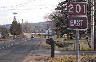
Route 201 is a collector road in the Canadian province of Nova Scotia.

<span class="mw-page-title-main">Nova Scotia Route 221</span>

Route 221 is a collector road in the Canadian province of Nova Scotia.

<span class="mw-page-title-main">Kings Transit</span>

Kings Transit Authority is a public transit agency operating buses in the Annapolis Valley, Nova Scotia. The system, incorporated in 1981, is funded by Kings County, Annapolis County, Digby County and the towns of Berwick, Wolfville, Kentville, Middleton, Annapolis Royal, and Digby.

<span class="mw-page-title-main">École Rose-des-Vents (Nova Scotia)</span> School in Greenwood, Nova Scotia, Nova Scotia, Canada

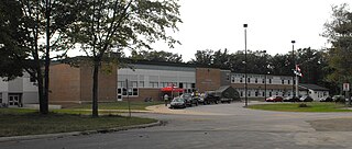
École Rose-des-Vents is a Francophone school located in Greenwood, Nova Scotia operated by the Conseil scolaire acadien provincial (CSAP).

<span class="mw-page-title-main">Southern Nova Scotia</span> Economic Region in Nova Scotia, Canada

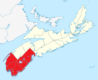
Southern Nova Scotia or the South Shore is a region of Nova Scotia, Canada. The area has no formal identity and is variously defined by geographic, county and other political boundaries. Statistics Canada, defines Southern Nova Scotia as an economic region, composed of Lunenburg County, Queens County, Shelburne County, Yarmouth County, and Digby County. According to Statistics Canada, the region had the highest decrease of population in Canada from 2009 to 2010, with a population decrease of 10.2 residents per thousand. The region also has the second-highest median age in Canada at 47.1 years old.

<span class="mw-page-title-main">Outline of Nova Scotia</span> Overview of and topical guide to Nova Scotia

The following outline is provided as an overview of and topical guide to Nova Scotia:

<span class="mw-page-title-main">Administrative divisions of Nova Scotia</span> Local governance within Nova Scotia

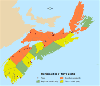
The Canadian province of Nova Scotia is divided into 49 municipalities, of which there are three types: regional (4), town (25), and county or district municipality (20).

References

  1. "Kings County Statistics". Municipality of Kings County . Retrieved October 24, 2018.
  2. "Clairmont Provincial Park | Tourism Nova Scotia, Canada".
  3. Echoes across the Valley, A History of Kingston and its Neighbors, Tony Cochrane, Editor, pp. 44-47, ISBN   0-88999-564-8, Lancelot Press, Hantsport, NS
  4. "Home". paragongolf.ca.