Municipality of the District of Guysborough

Last updated

Guysborough
Municipality of the District of Guysborough
Old Courthouse Museum Info Centre Guysborough Nova Scotia.jpg
Municipality of guysborough flag.gif
Guysborough NS logo.png
Guysborough Municipal District - Nova Scotia.PNG
Location of the Municipality of the District of Guysborough
Coordinates: 44°26′00″N064°35′57″W / 44.43333°N 64.59917°W / 44.43333; -64.59917 Coordinates: 44°26′00″N064°35′57″W / 44.43333°N 64.59917°W / 44.43333; -64.59917
CountryCanada
Province Nova Scotia
County Guysborough
IncorporatedApril 17, 1879
Government
  TypeCouncil of the Municipality
of the District of Guysborough
   Municipal Seat Guysborough
  WardenVernon Pitts
Area
[1]
  Land2,116.86 km2 (817.32 sq mi)
Population
 (2016) [2]
  Total4,670
  Change 2011-16
Decrease2.svg6.5%
  Census ranking
751 of 4,870
Electoral districts
   Federal Cape Breton—Canso
   Provincial Guysborough–Eastern Shore–Tracadie
Time zone UTC-4 (AST)
  Summer (DST) UTC-3 (ADT)
Area code 902
Dwellings2,889
Median Income*$34,987 CDN
Website www.municipality.guysborough.ns.ca OOjs UI icon edit-ltr-progressive.svg
  • Median household income, 2005 (all households)

Guysborough, officially named the Municipality of the District of Guysborough, is a district municipality in Guysborough County, Nova Scotia, Canada. Statistics Canada classifies the district municipality as a municipal district.

Contents

It is home to the Boylston and Salsman Provincial Parks. The parks are located between Boylston and Guysborough.

History

The area was originally called Chedabouctou and was the site of one of a fishing post of Nicolas Denys. In 1682, a permanent settlement was started by Clerbaud Bergier. A group cleared land and spent the winter with the first crops being planted in 1683. Louis-Alexandre des Friches de Meneval landed at Chedabouctou in 1687 when arriving to take up his position as governor of Acadia. The community is named after Sir Guy Carleton. [3]

Geography

Occupying the eastern half of Guysborough County, the district municipality's administrative centre is the community of Guysborough. The district completely surrounds the Town of Mulgrave and it borders the Municipality of the District of St. Mary's to the west, the Municipality of the County of Antigonish to the north and the Strait of Canso to the east.

Demographics

In the 2021 Census of Population conducted by Statistics Canada, the Municipality of the District of Guysborough had a population of 4,585 living in 2,220 of its 3,043 total private dwellings, a change of

Economy

Various mining and energy (natural gas) projects have been developed in Guysborough, including around the Southwestern town of Goldboro, Nova Scotia where a $10 Billion liquefied natural gas LNG terminal and pipeline project is being pursued by the Canadian firm Pieridae Energy.

See also

Related Research Articles

<span class="mw-page-title-main">Annapolis County, Nova Scotia</span> County in Nova Scotia, Canada

Annapolis County is a county in the Canadian province of Nova Scotia located in the western part of the province located on the Bay of Fundy. The county seat is Annapolis Royal.

<span class="mw-page-title-main">Colchester County</span> County in Nova Scotia, Canada

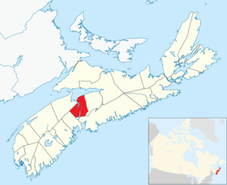
Colchester County is a county in the Canadian province of Nova Scotia. With a population of 51,476 the county is the fourth largest in Nova Scotia. Colchester County is located in north central Nova Scotia.

<span class="mw-page-title-main">Cumberland County, Nova Scotia</span> County in Nova Scotia, Canada

Cumberland County is a county in the Canadian province of Nova Scotia.

<span class="mw-page-title-main">Guysborough County, Nova Scotia</span> County in Nova Scotia, Canada

Guysborough County is a county in the Canadian province of Nova Scotia.

<span class="mw-page-title-main">Inverness County, Nova Scotia</span> County in Nova Scotia, Canada

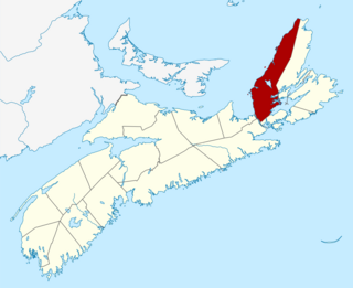
Inverness County is an historical county and census division of Nova Scotia, Canada. Local government is provided by the Municipality of the County of Inverness, the town of Port Hawkesbury and the Whycocomagh 2 Waycobah First Nation reserve.

<span class="mw-page-title-main">Lunenburg County, Nova Scotia</span> County in Nova Scotia, Canada

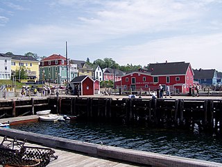
Lunenburg County is a historical county and census division on the South Shore of the Canadian province of Nova Scotia. Major settlements include Bridgewater, Lunenburg, and Mahone Bay.

<span class="mw-page-title-main">Richmond County, Nova Scotia</span> County in Nova Scotia, Canada

Richmond County is an historical county and census division of Nova Scotia, Canada. Local government is provided by the Municipality of the County of Richmond.

<span class="mw-page-title-main">Municipality of the District of Lunenburg</span> District municipality in Nova Scotia, Canada

The Municipality of the District of Lunenburg, is a district municipality in Lunenburg County, Nova Scotia, Canada. Statistics Canada classifies the district municipality as a municipal district.

<span class="mw-page-title-main">Municipality of the District of Argyle</span> District municipality in Nova Scotia, Canada

Argyle, officially named the Municipality of the District of Argyle, is a district municipality in Yarmouth County, Nova Scotia. Statistics Canada classifies the district municipality as a municipal district.

<span class="mw-page-title-main">Municipality of the District of Barrington</span> District municipality in Nova Scotia, Canada

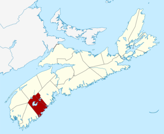
Barrington, officially named the Municipality of the District of Barrington, is a district municipality in western Shelburne County, Nova Scotia, Canada. Statistics Canada classifies the district municipality as a municipal district.

<span class="mw-page-title-main">Region of Queens Municipality</span> Municipality in Nova Scotia, Canada

The Region of Queens Municipality is a regional municipality in southwestern Nova Scotia, Canada. It is the northern gateway of the UNESCO Southwest Nova Biosphere Reserve, a centre of outdoor activities. Campgrounds at Kejimukujik National Park and National Historic Site, Thomas H. Raddall Provincial Park, and several other locations offer hiking, biking, canoeing, kayaking, cross-country skiing and snowshoeing. Its seacoast and inland areas are popular photo locations.

<span class="mw-page-title-main">West Hants Regional Municipality</span> Regional municipality in Nova Scotia, Canada

West Hants, officially named the West Hants Regional Municipality, is a regional municipality in Hants County, Nova Scotia, Canada.

<span class="mw-page-title-main">Municipality of the District of Shelburne</span> District municipality in Nova Scotia, Canada

District of Shelburne, officially named the Municipality of the District of Shelburne, is a district municipality comprising the eastern section of Shelburne County, Nova Scotia, Canada, but does not include the Towns of Shelburne or Lockeport. Statistics Canada classifies the district municipality as a municipal district. It is home to the Bowers Meadows Wilderness Area.

<span class="mw-page-title-main">Mulgrave, Nova Scotia</span> Town in Nova Scotia, Canada

Mulgrave is a town on the Strait of Canso in Guysborough County, Nova Scotia, Canada. Located along the Marine Drive, Route 344 traverses the community. The town's current name was adopted in 1859 to honour the colonial Lieutenant Governor, the Earl of Mulgrave. Lying opposite to the town of Port Hawkesbury, the community is located along the western shore of the Canso Strait. It was established as McNair's Cove in the early 19th century, and the name Port Mulgrave was adopted in 1859, later shortening to its current form. The early industry of the community relied on ferry service between the Nova Scotia mainland and Cape Breton Island. Ferry service began in the 1810s and rail service reached the area in the 1880s. The ferry services lasted until the opening of the Canso Causeway in 1955, dealing a major blow to the local economy. As of 2016, Mulgrave has a population of 722 and a population density of 40.5/km2 (104.9/sq mi), within an area of 17.83 km2 (6.88 sq mi).

<span class="mw-page-title-main">Municipality of the District of Yarmouth</span> District municipality in Nova Scotia, Canada

Yarmouth, officially named the Municipality of the District of Yarmouth, is a district municipality in Yarmouth County, Nova Scotia, Canada. Statistics Canada classifies the district municipality as a municipal district.

<span class="mw-page-title-main">Municipality of the District of St. Mary's</span> District municipality in Nova Scotia, Canada

St. Mary's, officially named the Municipality of the District of St. Mary's, is a district municipality in Guysborough County, Nova Scotia, Canada. Statistics Canada classifies the district municipality as a municipal district.

<span class="mw-page-title-main">Municipality of the District of Digby</span> District municipality in Nova Scotia, Canada

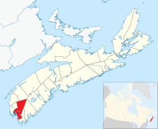
Digby, officially named the Municipality of the District of Digby, is a district municipality in Digby County, Nova Scotia, Canada. Statistics Canada classifies the district municipality as a municipal district.

<span class="mw-page-title-main">Antigonish County</span> County in Nova Scotia, Canada

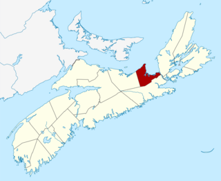
Antigonish County is a historical county and census division of Nova Scotia, Canada. Local government is provided by the Municipality of the County of Antigonish, the Town of Antigonish, and by two reserves: Pomquet and Afton 23, and Summerside 38.

References

  1. 1 2 2006 Statistics Canada Community Profile: Guysborough Municipal District, Nova Scotia
  2. "Population and dwelling counts, for Canada, provinces and territories, and census subdivisions (municipalities), 2016 and 2011 censuses – 100% data (Nova Scotia)". Statistics Canada. February 8, 2017. Retrieved February 12, 2017.
  3. "Place-names of the Province of Nova Scotia". Halifax, N.S. Royal Print. & Litho. 1922.
  4. "Population and dwelling counts: Canada, provinces and territories, census divisions and census subdivisions (municipalities), Nova Scotia". Statistics Canada. February 9, 2022. Retrieved March 12, 2022.
  5. Statistics Canada: 1996, 2001, 2006 census
  6. 2011 Census